February 28 , 2024.
Iceland , Reykjanes Peninsula :
Increased likelihood of a volcanic eruption in the coming days. Raised hazard levels in an updated hazard assessment.
Updated 27. February at 13:00 UTC
Accumulated magma beneath Svartsengi reaching same amount as prior to previous eruptions , An eruption could start with very little warning time, even less than 30 minutes.
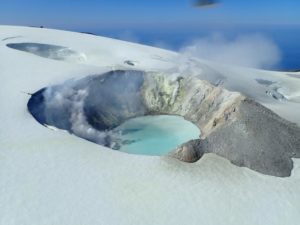
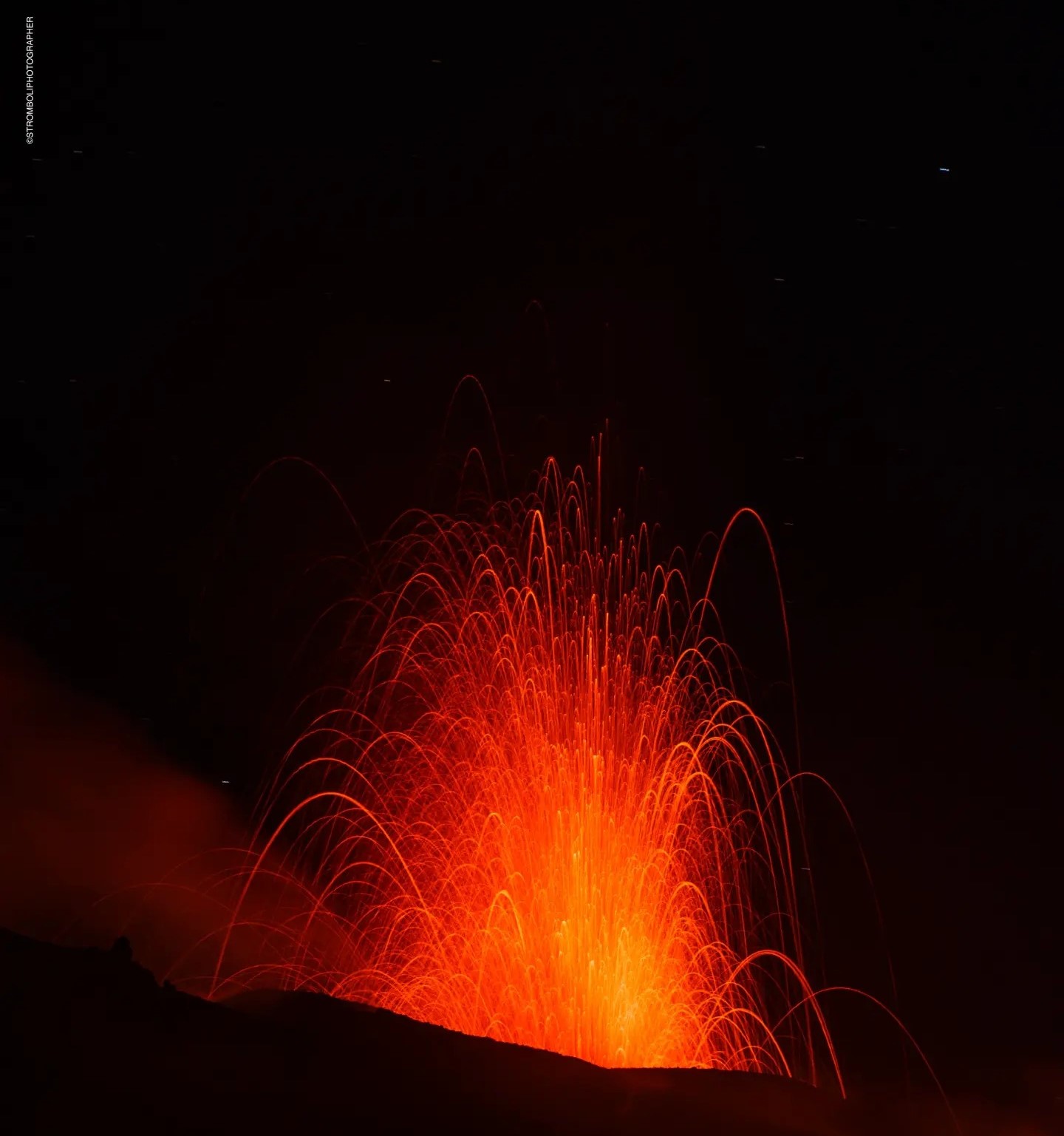
Lava from the eruption 8. February 2024
Raised hazard levels in an updated hazard assessment due to impending eruption.
Eruption location is most likely in the area between Mt. Stóra-Skógfell and Mt. Hagafell.
The hazard assessment does not account for weather conditions or other factors that may affect the risk of being within the hazard zones.
It is possible that a dike intrusion occurs without resulting in a volcanic eruption
Model calculations suggest that about 7.6 million m3 of magma has been recharged within the Svartsengi reservoir. Considering precursors of previous volcanic eruption in the Sundhnúkar crater row, likelihood of a volcanic eruption increases once the volume of magma reaches 8 – 13 million m3. If magma accumulation continues at the same rate, the amount should reach the lower limit tomorrow (27th of February).
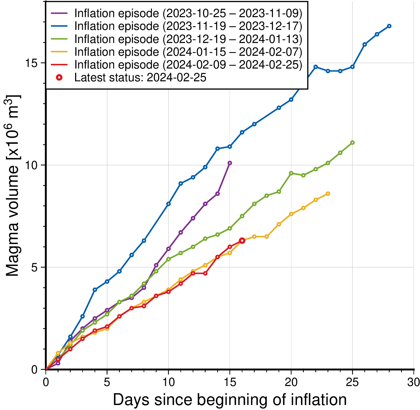
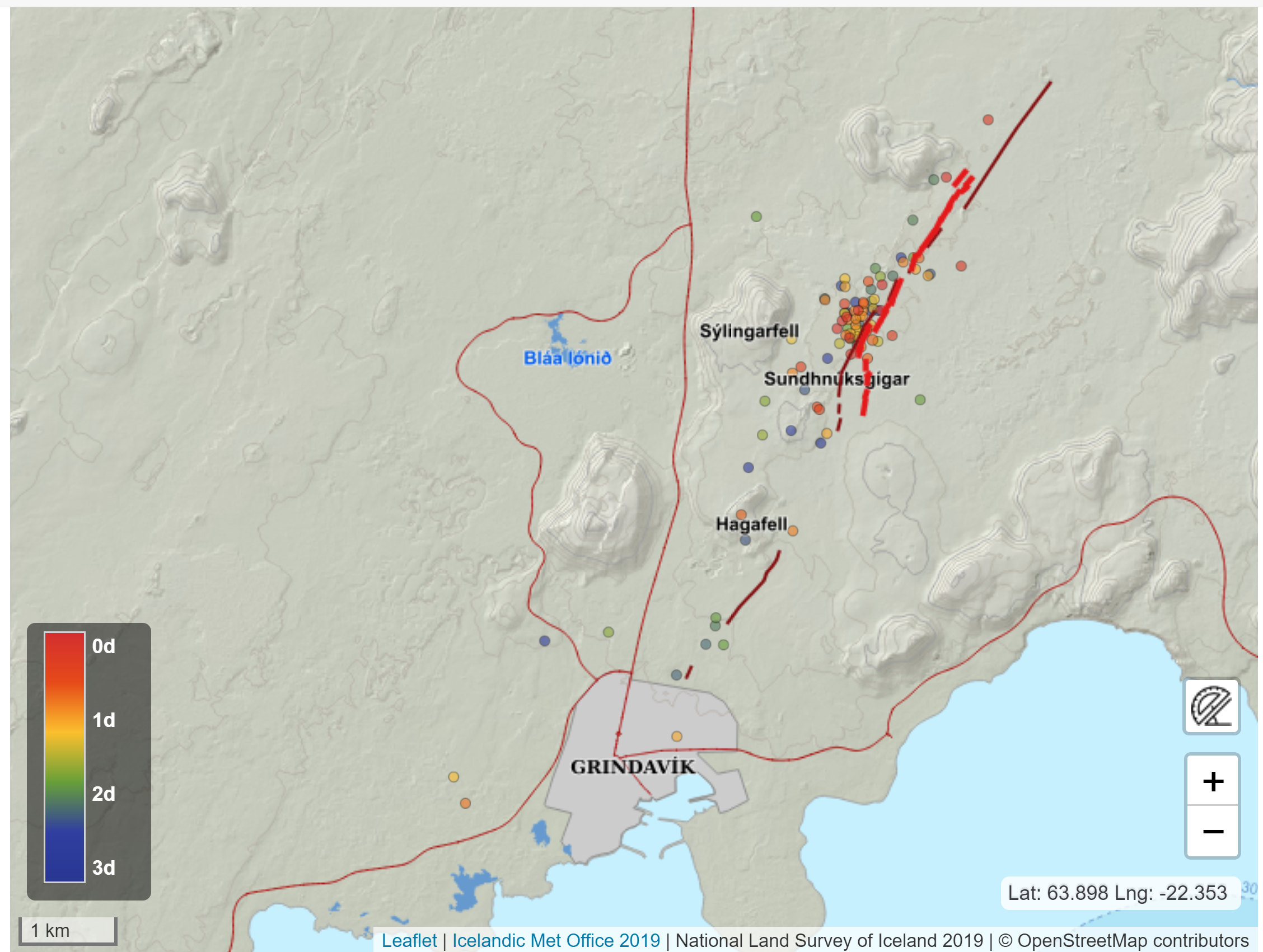
Seismic activity has increased slightly since past weekend and has been most prominent just east of Mt. Sýlingarfell. The location of the seismic activity is in an area which is considered to be the eastern tip of the magma reservoir which is centered beneath the Svartsengi-Þórbjörn area. The current seismicity is similar to that observed days before previous volcanic eruptions in the area.
Therefore, IMO has updated the hazard assessment for the unrest area. Increased likelihood of a volcanic eruption and related hazards affects the assessment. Hazard levels have been raised in several zones. Even though the color of Zone 4 – Grindavík – remains unchanged, the hazards there have increased due to the possibility of lava flows. Same goes for Zone 1 – Svartsengi.
No significant deformation within Grindavík has been detected by GNSS or satellite data. It is however likely that new faults will be revealed when snow melts or precipitation causes soil, which might be covering faults, to be washed away.
Likely scenarios
If an eruption occurs, scientists estimate that magma will most likely propagate from the reservoir beneath the Svartsengi-Þórbjörn region towards Sundhnúkur crater row, resulting in lava fountaining and lava flows in the area between Stóra-Skógfell and Hagafell. The primary signal of ascending magma is a sudden increase in seismic activity with many localized, small magnitude earthquakes. Considering the previous volcanic eruptions in the area, an eruption could start with very little warning (less than 30 minutes), depending on where magma reaches the surface on the Sundhnúkur crater row.
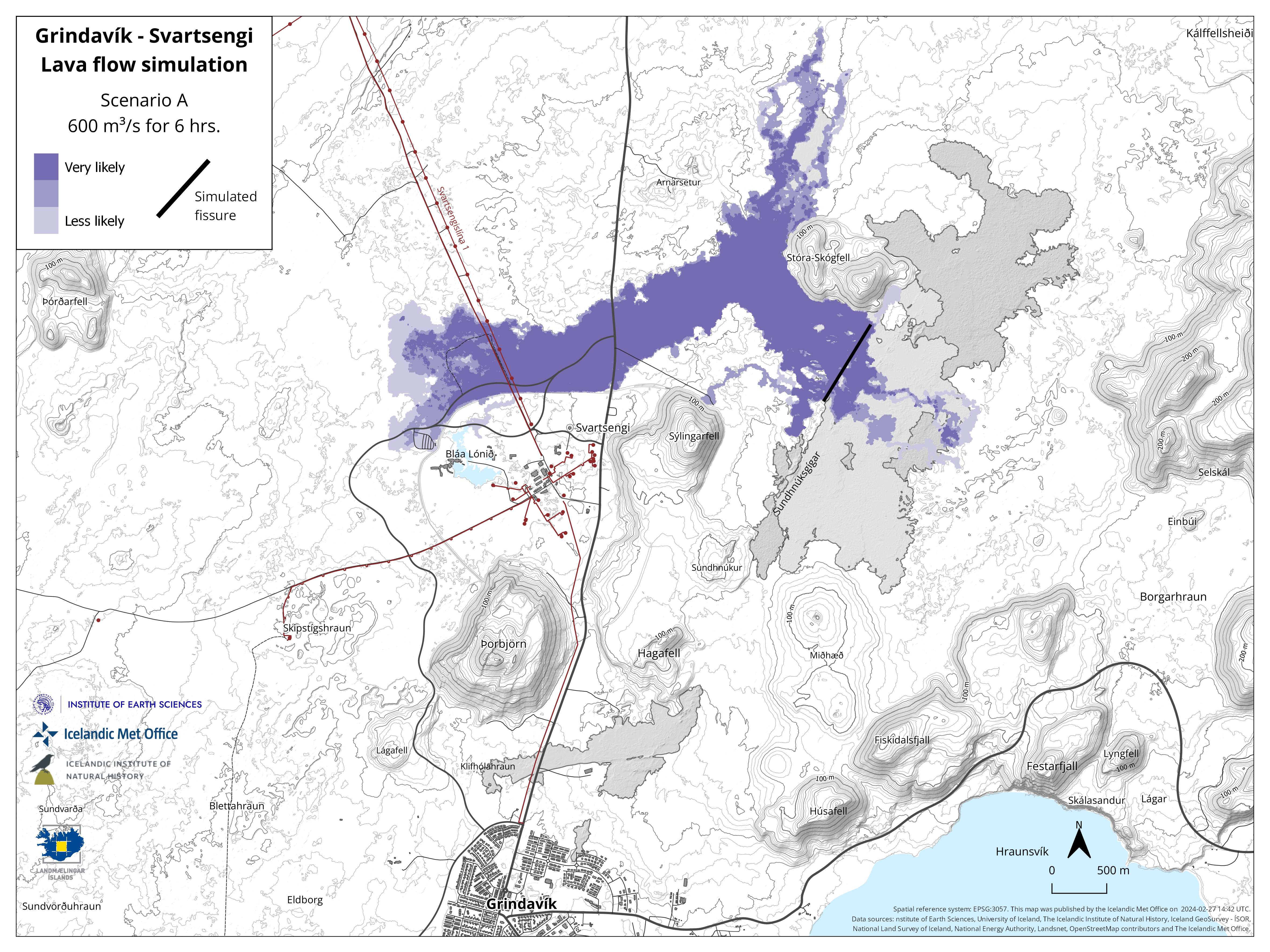
At a community meeting held today with residents of Grindavík, IMO presented results from lava flow models, showing scenarios considered to be likely and which were explained before last weekend.
The modelled results presented showed estimated lava flow from two separate eruptive fissures located on the Sundhnúkur crater row. The lava flow models do not forecast the behaviour of the next volcanic eruption. The models are only used to predict possible lava flow pathways from different locations of eruptive fissures.
Many factors affect a lava flow: location and length of the eruptive fissure, volume of erupted material, topography of the land surface and whether craters or lava lobes form.
These modelled scenarios predict lava flowing from an 800 m long eruptive fissure with a constant extrusion rate of 600 m3/s. The fissures are shown on the maps as black lines.
These modelled results below are therefore only 2 examples for the Sundhnúkar crater row, but the behaviour of the lava flow in the next volcanic eruption can be very different depending on where exactly a fissure opens on the surface and how long it will be. A minor shift in location can significantly alter the lava flow pathway.
Eruption between Sýlingarfell and Stóra-Skógfell – As occurred on December 18, 2023 and February 8, 2024.
Precursor: Sudden, localized, and intense seismic activity with small magnitude earthquakes. Deformation over the magma dike (if a dike is intruded) and the Svartsengi magma reservoir
Very short warning time (less than 30 minutes) because a new dike propagation may not be required for magma to reach the surface.
Lava reaches Grindavík road in less than 4 hours.
Eruption by Hagafell – As occurred on January 14, 2024.
Precursor: Seismic activity with small magnitude earthquakes on the Sundhnúkur crater row, starting near Sýlingarfell and migrating south. Deformation over the magma dike and the Svartsengi magma reservoir
Likely warning time is approximately 1-3 hours from the detection of the first earthquakes until the start of an eruption.
Lava reaches the lava barriers around Grindavík within 1 hour.
Magma intrusion, which reaches south of Hagafell, will likely cause significant fault movements in Grindavík
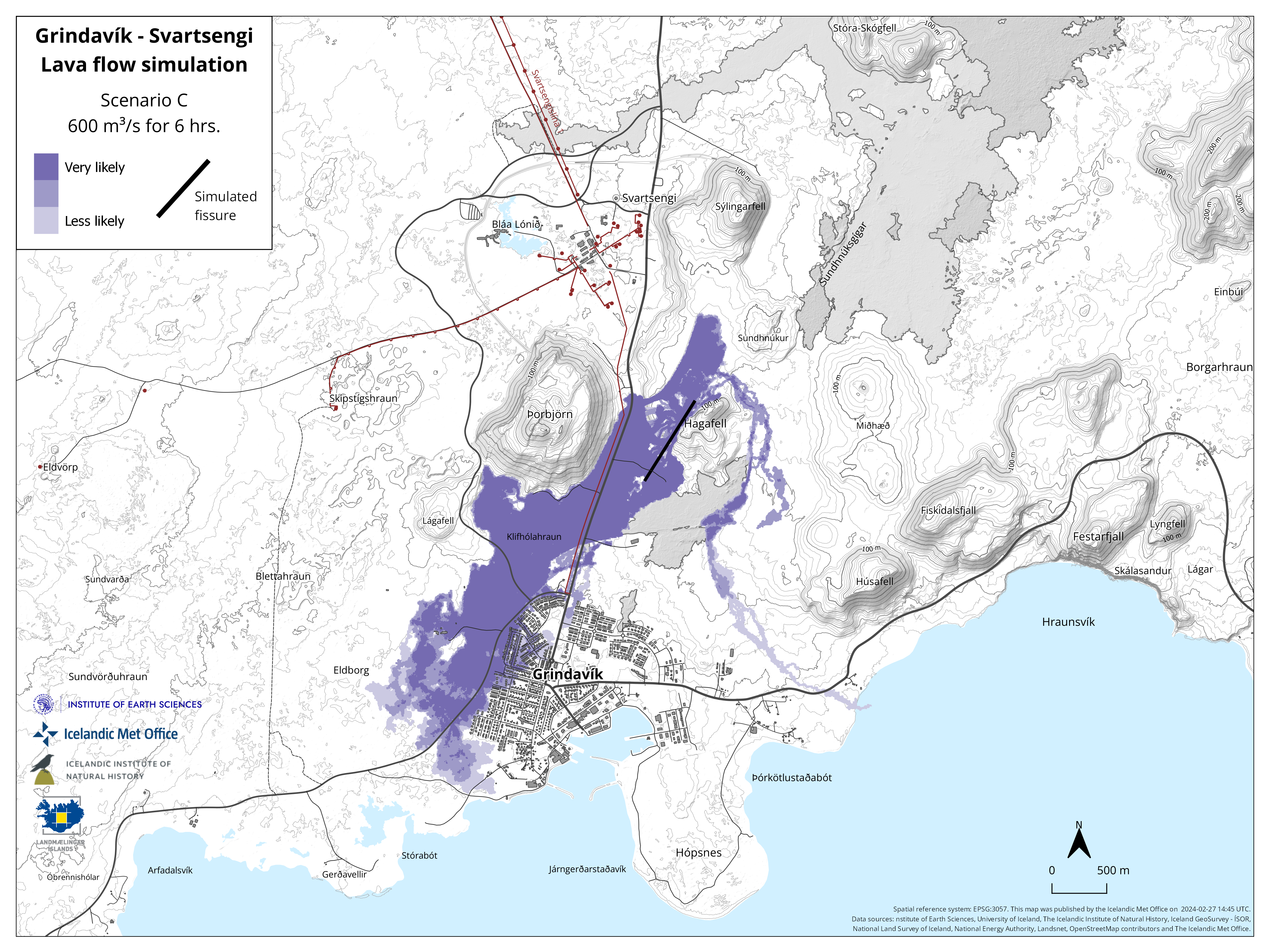
Eruption inside of the lava barriers around Grindavík
Seismic activity with small magnitude earthquakes on the Sundhnúkur crater row, starting near Sýlingarfell and migrating south. Deformation over the magma dike and the Svartsengi magma reservoir
Probable warning time is between approximately 1-5 hours from the detection of the first earthquakes until the start of an eruption.
It is possible that an eruptive fissure/s will open within Grindavík or the region just north of here (inside the barriers). Similar activity occurred on the 14th of January when a volcanic fissure opened just inside the outer perimeter of the town approximately 4 hours after an onset of the eruption near Hagafell.
Magma intrusion, which reaches south of Grindavík, will cause significant fault movements in Grindavík.
Source : IMO
Graphiques : IMO
Photo : Birgir Vilhelm Óskarsson/Institut islandais d’histoire naturelle.
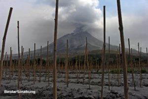
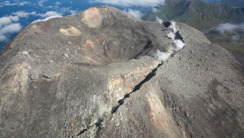
Italy , Stromboli :
WEEKLY BULLETIN, from February 19, 2024 to February 25, 2024. (issue date February 27, 2024)
SUMMARY STATEMENT OF ACTIVITY
In light of the monitoring data, it appears:
1) VOLCANOLOGICAL OBSERVATIONS: Normal Strombolian activity was observed during this period. The total hourly frequency fluctuated between average values (8-14 events/h). The intensity of the explosions was low to medium in the North Crater area and variable from low to high in the South-Central area.
2) SISMOLOGY: The monitored seismological parameters do not show significant variations.
3) GROUND DEFORMATIONS: The island’s ground deformation monitoring networks showed no significant changes to report for the period under review.
4) GEOCHEMISTRY: Mid-level SO2 flux.
The CO2 flux in the summit area shows high values.
C/S ratio in the plume: there are no updates.
The helium isotope ratio in the thermal aquifer shows high values (sampling on February 15, 2024).
CO2 flow in Scari: remains at average values.
5) SATELLITE OBSERVATIONS: Thermal activity observed by satellite was generally weak.
VOLCANOLOGICAL OBSERVATIONS
In the observed period, the eruptive activity of Stromboli was characterized through the analysis of images recorded by the INGV-OE surveillance cameras located at Pizzo (SPT), at altitude 190 m (SCT-SCV) and at Punta dei Corvi (SPCT). The explosive activity was mainly produced by 2 (two) eruptive vents located in the northern area of the crater and by 2 (two) vents located in the south central area.
Due to the interruption of the video signal, images of the explosive activity were not observed from 15:43 UTC on February 24 until the end of the analyzed period (February 25).
Observations of explosive activity captured by surveillance cameras
In the area of the North crater (N), with a mouth located in sector N1 and a mouth located in sector N2, explosive activity was observed mainly of low intensity (less than 80 m height) in sector N2 and of medium intensity (less than 80 m high to more than 150 m high) in sector N1. The products emitted in the eruption were mainly coarse materials (bombs and lapilli). The average frequency of explosions oscillated between 3 and 6 events/h. In the South-Central (CS) zone, sector C did not show significant activity. In sector S1, modest and sporadic gas jets were observed while in sector S2 the explosions were of variable intensity ranging from low (less than 80 m in height) to high (greater than 150 m in height) emitting fine materials mixed with coarse materials. The average frequency of explosions varied between 5 and 10 events/h.
Source : INGV
Photo : Stromboli stati d’animo / Sebastiano Cannavo.
Alaska , Kanaga :
AVO/USGS Volcanic Activity Notice
Current Volcano Alert Level: NORMAL
Previous Volcano Alert Level: ADVISORY
Current Aviation Color Code: GREEN
Previous Aviation Color Code: YELLOW
Issued: Tuesday, February 27, 2024, 11:10 AM AKST
Source: Alaska Volcano Observatory
Notice Number: 2024/A217
Location: N 51 deg 55 min W 177 deg 9 min
Elevation: 4288 ft (1307 m)
Area: Aleutians
Summit of Kanaga Volcano, with prominent fracture that formed in 2012
Volcanic Activity Summary:
Volcanic unrest at Kanaga Volcano has subsided over the past several weeks and the Aviation Color Code is being decreased to GREEN and the Volcano Alert Level to NORMAL. Seismicity, which was elevated following a small explosion and ground-cracking event on December 18, 2023, has decreased to background levels. Satellite data show that there have been no recent surface changes, elevated temperatures, or gas emissions. When atmospheric conditions are favorable, web camera and satellite data show intermittent steaming from the crack near the summit crater.
Local seismic and infrasound sensors and web cameras are used to monitor Kanaga. AVO also uses regional infrasound and lightning networks and a variety of satellite data.
Remarks:
Kanaga Volcano occupies the northern corner of Kanaga Island, one of the most southerly members of the central Aleutian chain. It is a symmetric composite cone 4288 ft (1307 m) high and 3 miles (4.8 km) in diameter at sea level, built of interbedded basaltic and andesitic lava flows, scoria layers, and pyroclastic rocks. Kanaga Volcano’s last significant eruption was in 1994–1995. At least two significant ash plumes were recorded over the course of this eruption: the first, to ~25,000 ft (7.5 km), occurred on February 21, 1995 and the second on August 18, 1995, when an eruption cloud reached ~15,000 ft. (4.5 km). A light dusting of ash fell on the community of Adak and air traffic was disrupted due to continuing low-level activity and cloudy conditions which prevented visual approaches to the Adak airfield.
Source : AVO
Photo : John Lyons, AVO/USGS
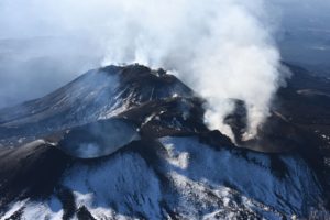
Italy / Sicily , Etna :
WEEKLY BULLETIN, from February 19, 2024 to February 25, 2024. (issue date February 27, 2024)
SUMMARY STATEMENT OF ACTIVITY
In light of the monitoring data, it appears:
1) VOLCANOLOGICAL OBSERVATIONS: Degassing activity from the Bocca Nuova crater and the South-East crater.
2) SEISMOLOGY: Low seismic activity due to fracturing. Average amplitude of the volcanic tremor at the intermediate level.
3) INFRASOUND: Moderate infrasound activity, with sources mainly located near the Bocca Nuova crater.
4) GROUND DEFORMATIONS: Over the past week, ground deformation monitoring networks have not recorded any significant changes.
5) GEOCHEMISTRY: SO2 flux at medium level
The soil CO2 flux recorded continuously by the EtnaGas network is at average values.
The partial pressure of CO2 dissolved in groundwater presents values included in seasonal variability.
The helium isotopic ratio is high.
6) SATELLITE OBSERVATIONS: Thermal activity observed by satellite was generally weak.
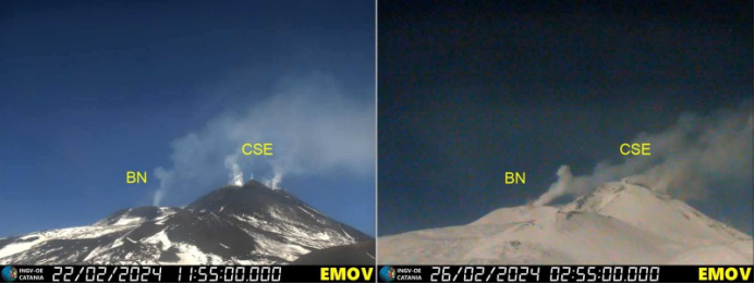
Images taken by the La Montagnola CCTV camera showing degassing activity from the Bocca Nuova Crater (BN) and the SE Crater (CSE).
VOLCANOLOGICAL OBSERVATIONS
During the week in question, the monitoring of the volcanic activity of Etna was carried out through the analysis of images from the network of surveillance cameras of the National Institute of Geophysics and Volcanology, Osservatorio Etneo (INGV- OE).
In particular, the activity of the summit craters was characterized by ordinary degassing activity from the Southeast crater (CSE) and the Bocca Nuova crater (BN).
During the week, the degassing activity continued without change compared to what was observed in the previous period (Rep. N. 08/2024 ETNA), continuously from the two main vents (« saddle » and « East ») of the Southeast Crater as well as certain fumaroles on the northern rim of the crater, and impulsively of the two pit craters (BN-1 and BN-2) inside the Bocca Nuova crater. The two other summit craters, Voragine and North-East Crater, are obstructed, with very little fumarolic activity.
Source : INGV.
Mexico , Popocatepetl :
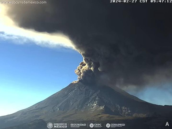
February 27, 11:00 a.m. (February 27, 5:00 p.m. GMT). Activity from the last 24 hours.
77 exhalations accompanied by water vapor, volcanic gases and ash were detected. In addition, 952 minutes of high-frequency, low-amplitude tremor (19.9 h) were identified, as well as a volcano-tectonic earthquake recorded today at 02:42 a.m. with calculated magnitude. of 1.2
CENACOM (National Center for Communications and Civil Protection Operations) reported light ash falls in the municipalities of Hueyapan and Tetela del Volcán, Morelos, as well as in Tepetlixpa and Ecatzingo, State of Mexico.
During the morning and at the time of this report, a continuous emission of volcanic gases and ash is observed, with dispersion towards the North-West (NW).
Updated at 6:30 p.m.
CENACOM (National Center for Communications and Civil Protection Operations) reported light ash falls during the day in the municipalities of Hueyapan, Yecapixtla and Tetela del Volcán, Morelos; in Ixtacuixtla, Panotla, Tepetitla, Nativitas, Zacatelco, Santa Apolonia Teacalco, San Damián Texóloc, Tetlahuaca, Zacatelco, Xicohtzingo, Paplotla, Tenancingo, Santa Catarina Ayometla, Magdalena Tlaltelulco, San Francisco Tetlanohcan and Teolocholco, Tlaxcala; in Iztacalco, Iztapalapa and Coyoacán, Mexico; and finally in Atlautla, Ayapango, Ecatzingo, Chalco, Tenango del Aire, Temamatla, Ozumba, Tepetlixpa, Tlalmanalco and Amecameca, State of Mexico.
We see that today’s activity is significantly lower than that of 2023.
The Popocatépetl volcanic warning fire is in yellow phase 2.
Source et photo : Cenapred .