October 28 , 2020 .
Italy / Sicily , Etna :
Weekly bulletin, from October 19, 2020 to October 25, 2020
(issue date October 27, 2020)
SUMMARY OF THE STATE OF ACTIVITY
In the light of surveillance data, it is highlighted:
1) VOLCANOLOGICAL OBSERVATIONS: Strombolian activity of variable frequency and intensity at the New Southeast Crater, accompanied by discontinuous emissions of volcanic ash and emissions of pieces of lava. Strombolian activity within the crater of the Northeast Crater. Ordinary degassing with rare and light emissions of diluted ash at the crater of Bocca Nuova and at the crater of Voragine.
2) SEISMOLOGY: Modest fracturing seismic activity; amplitude of the volcanic tremor at the average level.
3) INFRASOUND: Modest infrasound activity.
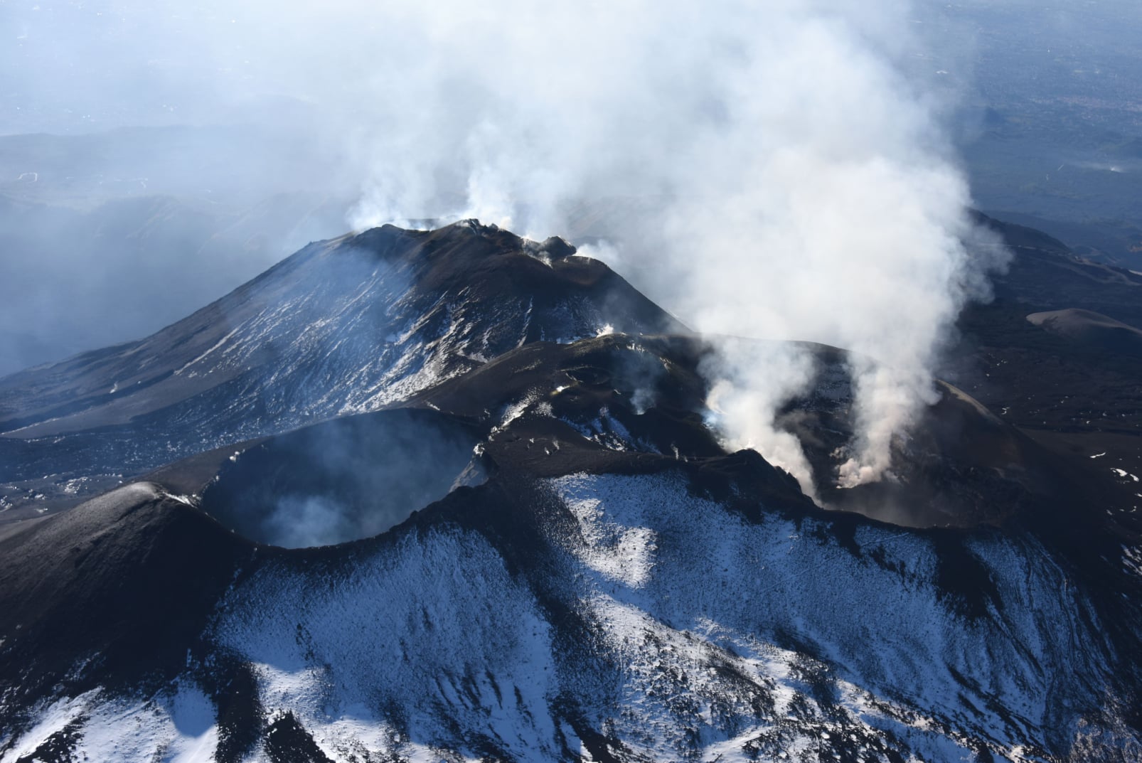
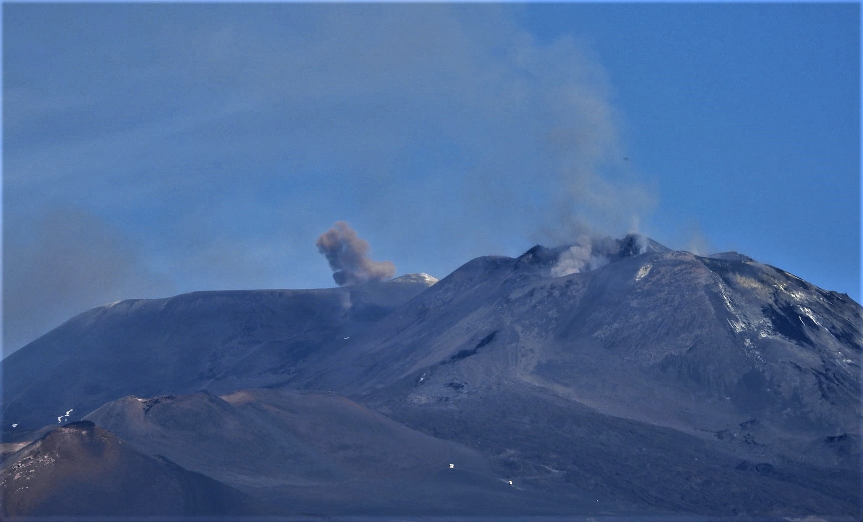
Panorama of summit craters seen by the coastguard helicopter, taken by the director of the INGV-Etnéo Observatory, Stefano Branca (October 23, 2020)
4) DEFORMATIONS: Etna soil deformation monitoring networks have not shown any significant changes over the past week.
5) GEOCHEMISTRY: The flow of SO2 occurs at a medium-low level.
HCl flux is at a low level.
Soil CO2 flux is at low degassing levels.
The partial pressure of dissolved CO2 does not show significant changes.
The value of the C / S ratio is at medium-low levels (last measurement dated 10/16/2020).
The isotope ratio of helium is at average values (last update of 10/14/2020).
6) SATELLITE OBSERVATIONS: The thermal activity in the summit area is at a medium-low level.
VOLCANOLOGICAL OBSERVATIONS
The monitoring of the volcanic activity at the level of the summit craters of Etna, during the week in question, was carried out by analyzing the images of the network of surveillance cameras of the INGV section of Catania, Osservatorio Etneo (INGV- OE). The observations were integrated through an overflight carried out with the helicopter made available by the 2nd Air Unit of the Catania Coast Guard on October 23 and an inspection carried out in the area of the summit craters by INGV staff on October 22.
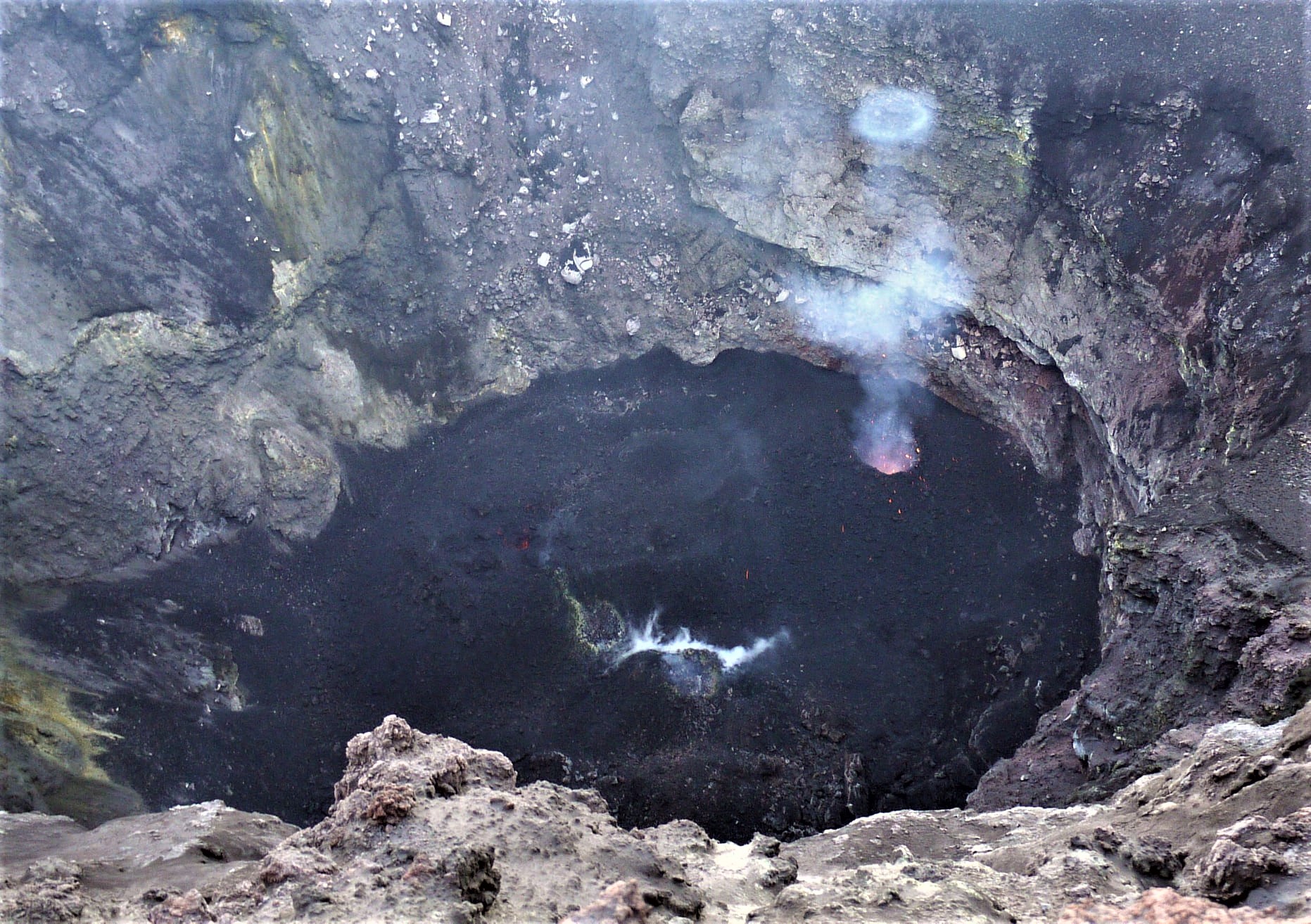
Photo of a steam ring generated by one of the very frequent explosions inside the Northeast Crater (October 22, 2020), Mauro Cotelli.
The flyby was performed along the west side, with a partial view of the New Southeast Crater (NSEC). Analysis of thermal images shows Strombolian activity of medium intensity with emissions of materials outside the crater rim.
At the bottom of the Northeast Crater (NEC), there are several areas with thermal anomalies whose apparent temperatures are 450 ° C + \ – 50 ° C.
On several aerial shots of the bottom of the crater of Bocca Nuova, it was possible to detect apparent temperatures between 250 ° and 200 ° C. These anomalies are mainly distributed in the eastern sector. Finally, no significant thermal anomaly was recorded at the Voragine crater (VOR).
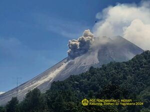
In detail, Strombolian activity at the New Southeast Crater (NSEC) was characterized by marked variability both in the frequency and intensity of individual explosive events, and in the type of products expelled. The activity, in fact, was characterized both by discontinuous ash emissions, sometimes quite intense, and by continuous degassing. It was also possible to observe the launching of fragments of lava which frequently exceeded the edge of the crater, a circumstance particularly evident at night and according to the images of the thermal cameras of the network.
Emission of ashes from the Bocca Nuova on the left, the Voragine, in the center center and the ′ ′ mouth of the saddle ′ ′ on the right (October 22, 2020). Boris Behncke.
In particular, in the early hours of October 23, a moderate and variable intensification of Strombolian activity was observed in the New Southeast Crater (NSEC) which produced an ash cloud which, in the distal zone, was observed. elevated about 4.5 km above sea level, dispersing to the south-southeast.
The analysis of the images taken with the INGV OE drones last 9/10 (bulletin 42/2020), made it possible to obtain the dimensions of the mouth of the saddle of the New Southeast Crater (NSEC), which measures 190 m along the major axis aligned in the northwest direction and 140 m along the minor axis elongated in the northeast direction.
In addition, at the level of the Voragine and Bocca Nuova craters, the activity was limited to degassing which was sometimes quite intense, accompanied by rare emissions of diluted ash, quickly dispersed in the atmosphere.
The deep intracrater Strombolian activity of some vents at the bottom of the Northeast Crater (NEC) continues, without significant changes, confirmed by an inspection in the summit area by INGV staff on October 22.
A more in-depth analysis of the images taken with the INGV OE drones the last 9/10, has made it possible to highlight the permanence, on the northern edge of the North-East crater (NEC), of a large fracture field of about 35 m wide and about 90m long, aligned approximately in the North-South direction, already observed since last July.
Source : INGV.
Photos : Stefano Branca , Mauro Cotelli , Boris Behncke .
Iceland , Reykjanes Peninsula :
Significant ground deformation detected associated with recent earthquakes , 27.10.2020
Last week a series of earthquakes occurred on the Reykjanes Peninsula, between Fagradalsfjall and Kleifarvatn – the largest of which was a magnitude 5.6 earthquake in the vicinity of Núpshíðarháls, which occurred at 13:43 on 20th October. The maps displayed here show ground deformation associated with movement on faults during the period 16th-22nd October.
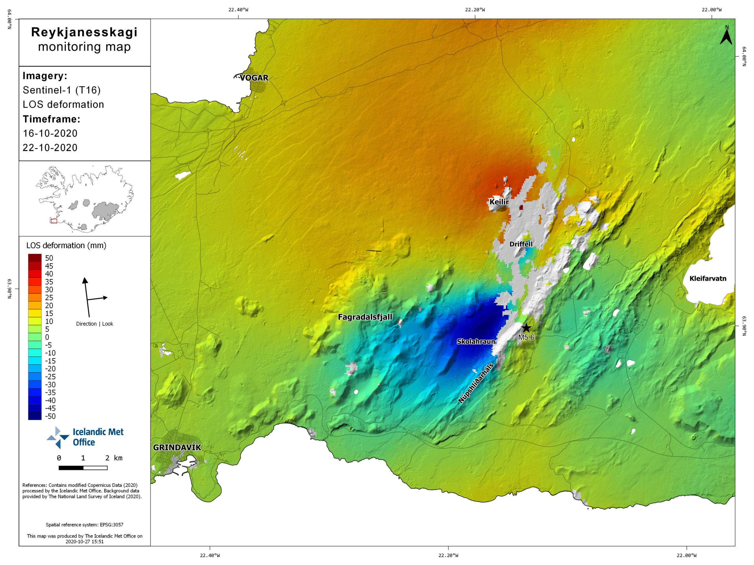
The large signal shown in the vicinity of Skolahraun represents movement of up to 5 cm (in the satellite’s line-of-sight) associated with the magnitude 5.6 earthquake. Additional deformation is observed in the vicinity of Driffell and east of Keilir, related to movement on faults in this region. Multiple fractures, related to these earthquakes, have been observed on the ground in this area.
These earthquakes are related to the volcano-tectonic reactivation of the Reykjanes Peninsula which commenced in December 2019. The unrest is ongoing and the occurrence of additional future earthquakes is considered likely.
Source : Vedur .
Italy , Stromboli :
Weekly bulletin, from October 19, 2020 to October 25, 2020
(issue date October 27, 2020)
SUMMARY OF THE STATE OF ACTIVITY:
In the light of surveillance data, it is highlighted:
1) VOLCANOLOGICAL OBSERVATIONS: Normal explosive volcanic activity of Strombolian type on medium-low levels (6-10 events / h) and with medium-low intensity in the area of the North craters and medium-high in the area of the central South craters.
2) SEISMOLOGY: The seismological parameters do not show significant variations.
4) DEFORMATIONS: The island’s soil deformation monitoring networks did not show any significant changes to report for the period under review.
5) GEOCHEMISTRY: Medium-low SO2 flux.
There are no updates on the soil CO2 flux data.
C / S Ratio – Latest values are average levels (8.7 – 10/25/2020 measurements).
Helium Isotopic Ratio – The latest measurements (05/10/2020) are average values, with a slightly increasing trend.
6) SATELLITE OBSERVATIONS: The thermal activity in the summit area is at a low level.
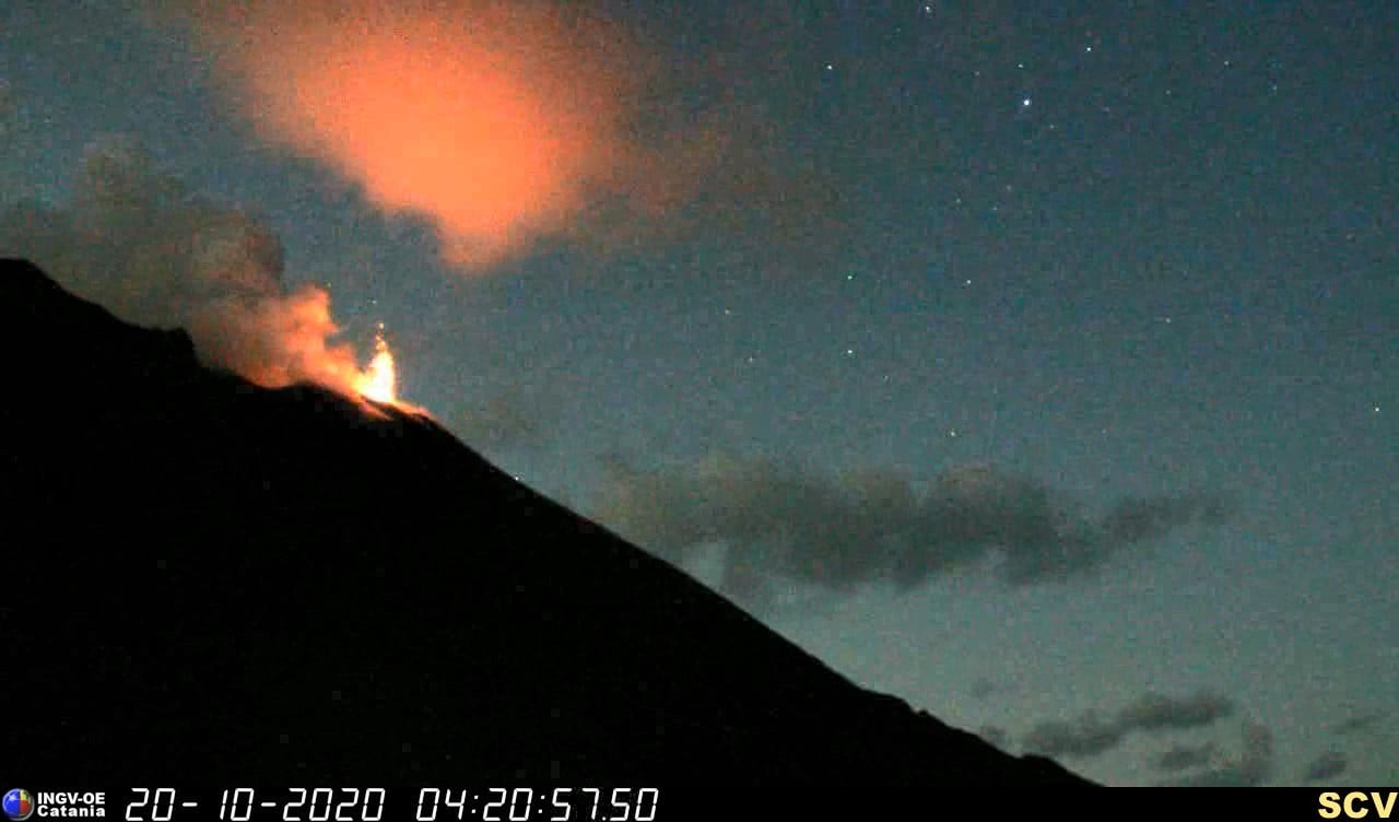
The image above shows an explosion in Stromboli at 04:20 UTC, October 20, 2020, recorded by the high-resolution camera located at an altitude of 190 m on the north side of Sciara del Fuoco.
VOLCANOLOGICAL OBSERVATIONS:
During the period under observation, the eruptive activity of Stromboli was characterized by the analysis of the images recorded by the surveillance cameras INGV-OE located at 190 m altitude, Punta dei Corvi and 400 m.
In the area of the North crater, the N1 crater, with two emission points, produced explosions of low (less than 80 m high) to medium intensity (less than 150 m high) emitting coarse materials (lapilli and bombs) sometimes mixed with fine materials (ash). Vent N2, with two emission points, showed mainly low and medium intensity explosive activity emitting coarse materials, sometimes mixed with fine materials. The average frequency of the explosions varied from 5 to 10 events / h.
In the Center-South zone, the explosions emitted mainly fine materials sometimes mixed with coarse materials, with a medium-high intensity (the products emitted often exceeded 250 m in height).
The explosive activity showed frequency values varying between less than 1 and 3 events / h.
The amplitude of the volcanic tremor had values between low and medium-low.
Source and photo : INGV .
Colombia , Nevado del Ruiz :
Weekly activity bulletin of the Nevado del Ruiz volcano
The activity level continues at: Yellow activity level or (III): changes in the behavior of volcanic activity.
Seismicity generated by fracturing of rock maintained similar levels in the number of earthquakes, with an increase in the seismic energy released compared to the previous week. This seismic activity was located mainly in the Arenas crater and in the South-South-East sector of the volcano. The depths of the earthquakes ranged from 0.2 to 8.9 km. The largest magnitude recorded during the week was 2.1 ML (local magnitude), which corresponds to the earthquake that occurred on October 20 at 5:39 p.m. (local time), located 2.3 km to the South-South East of the Arenas crater, 3.3 km deep.
During the week, several episodes of low-energy seismicity were recorded, associated with fracturing of the rock. The seismicity related to the dynamics of the fluids, inside the volcanic conduits, slightly decreased in the number of events and increased in the seismic energy released, compared to the previous week. This seismic activity was characterized by the occurrence of continuous volcanic tremors, tremor pulses, earthquakes of long and very long period type, which presented variable energy levels and spectral content. Some of these signals were associated with gas and ash emissions, confirmed by cameras installed on the volcano and by notifications from the Washington VAAC (Volcanic Ash Advisory Center).
The deformation of the volcanic surface, measured using GNSS (Global Navigation Satellite System) stations and electronic inclinometers, did not show any additional changes compared to those reported in recent weeks.
Source : SGC.
Photo : Fuerza Aérea Colombiana.