
June 16 , 2020 .
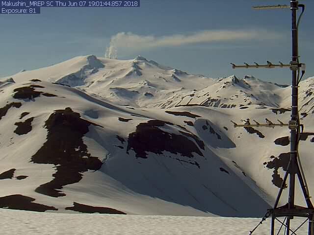
Alaska , Makushin :
AVO/USGS Volcanic Activity Notice
Current Volcano Alert Level: ADVISORY
Current Aviation Color Code: YELLOW
Issued: Monday, June 15, 2020, 6:02 PM AKDT
Source: Alaska Volcano Observatory
Location: N 53 deg 53 min W 166 deg 55 min
Elevation: 5906 ft (1800 m)
Area: Aleutians
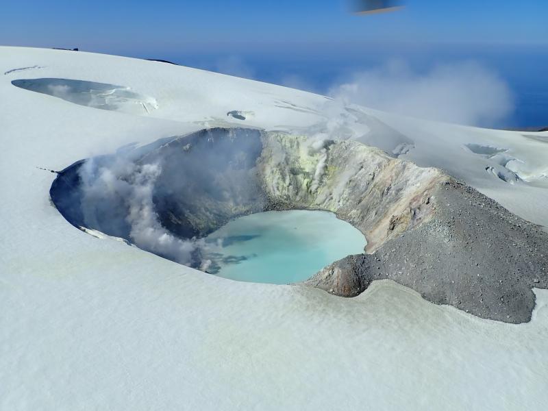
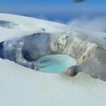
August 2019 views of the summit crater of Makushin Volcano. Heat from vigorous fumarolic activity is melting depressions, holes, and caves in the glacial ice. A low plume of sulfurous volcanic gases drifts off to the NNE.
Volcanic Activity Summary:
Over the past several hours, there have been two earthquakes larger than magnitude 4 in the vicinity of Makushin Volcano. This represents a significant departure from background earthquake activity and may be associated with volcanic unrest. As a result the Aviation Color Code and Volcano Alert Level has been increased to YELLOW/ADVISORY. This unrest could result a future eruption, however that is not a certainty. Aftershocks continue, as would be expected with earthquakes of this size. The volcano is monitored with a network of seismic instruments, web camera, GPS, satellite data, and regional infrasound and lightning detection instruments.
Recent Observations:
[Volcanic cloud height] No cloud produced.
[Other volcanic cloud information] n/a
Remarks:
Makushin volcano is located on northern Unalaska Island in the eastern Aleutian Islands. Makushin is a broad, ice-capped stratovolcano which rises to an elevation of 6680 feet. The summit caldera, 3 km diameter, is the site of frequent steam and minor ash eruptions; however, no large eruptions have occurred in this century. The community of Unalaska and port of Dutch Harbor are located 25 km (16 miles) east of Makushin volcano.
Source : AVO.
Photos : Kaufman, Max.
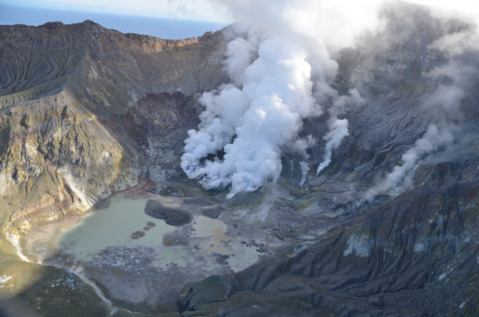
New Zealand , White Island :
Volcanic Alert BulletinWI – 2020/10
Tue Jun 16 2020 9:30 AM; Whakaari/White Island Volcano
Volcanic Alert Level is lowered to 1
Aviation Colour Code remains at Yellow
Based on the slowly decreasing level of volcanic activity and confirmation that the recently observed gas pulse was short-lived, the Volcanic Alert Level for Whakaari/White Island is now lowered to Level 1. The Aviation Colour Code remains at Yellow.
Observations and monitoring data over the last few months indicate that Whakaari/White Island has been progressing on a gradual trend back to lower levels of unrest that are typical of the long-term behaviour of this volcano. The decision to lower the Volcanic Alert Level to Level 1 is not as a result of recent changes in a single data set. Instead, it is based on the GNS Science volcano monitoring team’s collective interpretation of all the monitoring data and of their trend over the past few months.
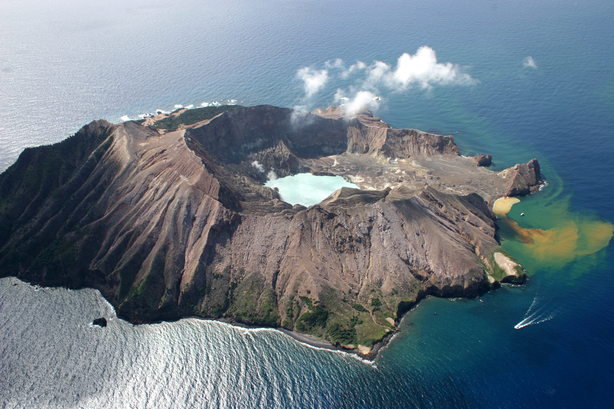
The data sets considered in our interpretation include discharge rate of sulphur dioxide (SO2) and carbon dioxide (CO2) gases, seismic activity, and the temperature of the discharging gases around the December 2019 eruption vents. While the temperature of the gas vents remains high, over 450oC some cooling has been observed over the last few months, indicating a slow decline in heat input from depth. The hot gases that are being emitted from gas vents around the December 2019 eruption vents are still sufficiently hot and are generating a ‘night glow’ that continues to be seen on GeoNet’s night-vision webcams.
New observations included in our interpretation of the activity at the volcano include a further flight to measure volcanic gas output, and improved views from the web camera overlooking the active crater. The gas observations on 12 June show similar rates of gas discharge to our observations on 3 June, confirming that the pulse of gas observed in late-May was short-lived.
This and changes in ground deformation rate in the vent area indicate that while some magma remains at shallow depth, estimated at about 1 km below the surface, gas discharge and ground deformation are not increasing. Seismic activity, specifically the level of volcanic tremor, has been low since February-March.
Taken together, these observations, coupled with consideration that the key data sets were stable or trending downward, the GNS Science’s volcanology monitoring team voted to lower the Volcanic Alert Level to Level 1. This indicates the most likely hazards are those expected during lower levels of volcanic unrest; steam discharge, volcanic gases, earthquakes, landslides and hydrothermal activity. While Volcano Alert Level 1 is associated with these environmental hazards, it doesn’t rule out the possibility of eruptions occurring with little or no warning.
The Volcanic Alert Level reflects the current level of volcanic unrest or activity and is not a forecast of future activity. Also, the Volcanic Alert Level doesn’t indicate the level of risk, it communicates that the volcano is no longer exhibiting moderate-heightened signs of unrest.
Since shortly after the 9 December 2019 eruption, no one has visited the island. As yet, we have not confirmed our plans to return to the island. A visit would include servicing of our equipment, recovery of equipment left on the island before the eruption and sampling the eruption deposits.
Despite GNS Science’s volcanology monitoring team’s decision to lower the Volcanic Alert Level based on careful consideration of recent observations, an eruption could still occur with little or no advanced warning. Plausible triggers for an eruption remain the collapse of unstable material from the crater walls onto the vents, increased release of gas from the shallow magma, and the ingress of water onto the shallow magma body.
Should any explosive activity produce an ash cloud, the likelihood of ash affecting the mainland remains very low. Under suitable weather conditions, the gas and steam plume may be noticed on the mainland as weak acid rain.
GNS Science and our National Geohazards Monitoring Centre continue to closely monitor Whakaari/White Island for further signs of activity. Further updates will be provided as needed.
Source : Geonet / Steven Sherburn , Duty Volcanologist.
Photos : R Fleming , Geonet .
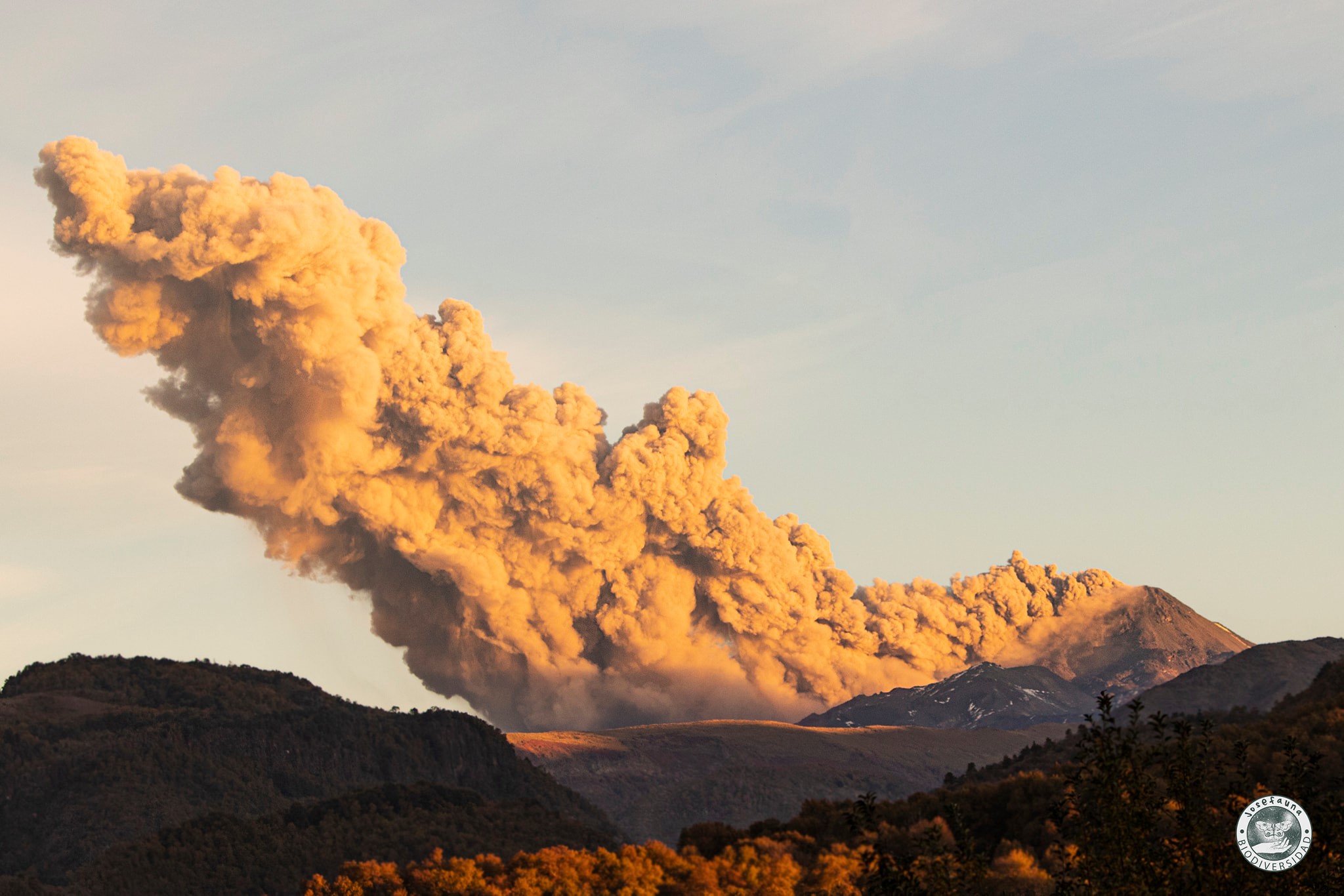
Peru , Sabancaya :
Analysis period: June 8 to 14, 2020
Arequipa, June 15, 2020
Alert level: ORANGE
The Peruvian Geophysical Institute (IGP) reports that the eruptive activity of the Sabancaya volcano remains at moderate levels; that is, with the continuous recording of explosions with columns up to 2.2 km high above the summit of the volcano and consequent emissions of ash and gas. Therefore, for the following days, no significant change is expected regarding his eruptive activity.
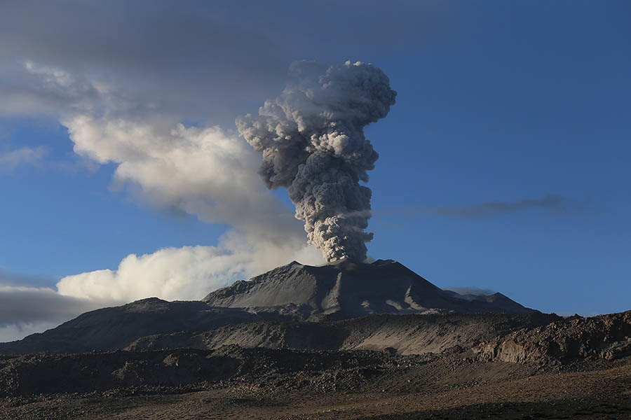
The IGP recorded and analyzed the occurrence of approximately 498 earthquakes of volcanic origin, associated with the circulation of fluids (magma, gas, etc.) on the Sabancaya volcano (Arequipa region). In addition, an average of 16 low to medium intensity explosions were recorded daily.
The monitoring of the deformation of the volcanic structure, using GNSS data (processed with fast orbits), does not present any significant anomalies; however, slight inflation was recorded in the North and Southeast sectors of the Sabancaya. Visual surveillance identified columns of gas and ash up to 2.2 km high above the summit of the volcano, which were mainly dispersed towards the Southwest, South, Southeast and East sectors. Satellite surveillance has identified the presence of 5 thermal anomalies with values between 2 MW and 19 MW, associated with the presence of a lava dome in the crater of the volcano being destroyed following an explosive activity.
RECOMMENDATIONS
• Keep the orange volcanic alert level.
• Do not approach within a radius of less than 12 km from the crater. In case of ash fall, cover your nose and mouth with rags or wet masks. Keep doors and windows of houses closed.
Source : IGP.
Photo : Photovolcanica.
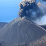
Chile, Nevados of Chillan :
Monitoring of the yellow alert for the municipalities of Pinto and Coihueco concerning the activity of the Nevados de Chillán volcanic complex
According to the information provided by the OVDAS – SERNAGEOMIN, through its special report on the volcanic activity (REAV) of the volcanic complex of Nevados de Chillán, we note that the technical alert level is maintained at the yellow level, which includes variations in the levels of the parameters derived from the monitoring which indicate that the volcano is above its base threshold and that the process is unstable, being able to evolve by increasing or decreasing these levels, therefore a probable eruption could develop over a period several weeks or months.
At the same time, compared to the last REAV, it is emphasized that satellite and deformation observations confirm the evolution of the volcanic system towards the location of a body of surface magma housed inside the active crater, as suggested in the REAV published on June 10 this year. The seismic signals recorded in the previous days share characteristics experienced during the processes of 2017-2018 (location of the lava dome) and 2019 (effusion of lava flows), both related to the release of magmatic material, confirming the presence of a new body on the surface.
Thus, given the recent morphological changes and the instrumental parameters of the internal dynamics of the volcano, an explosive scenario of moderate magnitude is expected. This is associated with the possibility of destabilization of the volcanic system, as a result of the addition of mass and heat from the new surface magmatic body.
In this scenario, the presence of eruptive columns up to 5 km high, ballistic projections, ash falls, avalanches of volcanic debris, the generation of pyroclastic currents at high speed (greater than 100 km / h) and high temperatures (above 200 ° C) due to the collapse of the column, are envisaged, the range of which could have an impact up to 5 kilometers towards the northeast sector of the active crater. Finally, the activity described, reinforced by the availability of water (snow or rain), can generate low-level lahars channeled by neighboring ravines.
In connection with the above, the yellow alert of the civil protection system is maintained, for the municipalities of Pinto and Coihueco, region of Ñuble, for the activity of the Nevados de Chillán volcanic complex, in force since December 31, 2015 and last time update on March 19, 2020.
During this time, the civil protection system must keep the emergency plans ready and recommend to the community not to approach the active crater, keeping a minimum distance of 2 kilometers.
Finally, the SERNAGEOMIN continues the permanent surveillance of the volcanic complex and the regional direction of ONEMI Ñuble will maintain coordination with the members of the civil protection system to alert in good time and give an adequate response to possible emergency situations.
Source : ONEMI.
Photo : Josefauna.


No comment yet, add your voice below!