January 28 , 2021 .
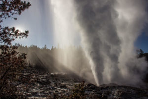
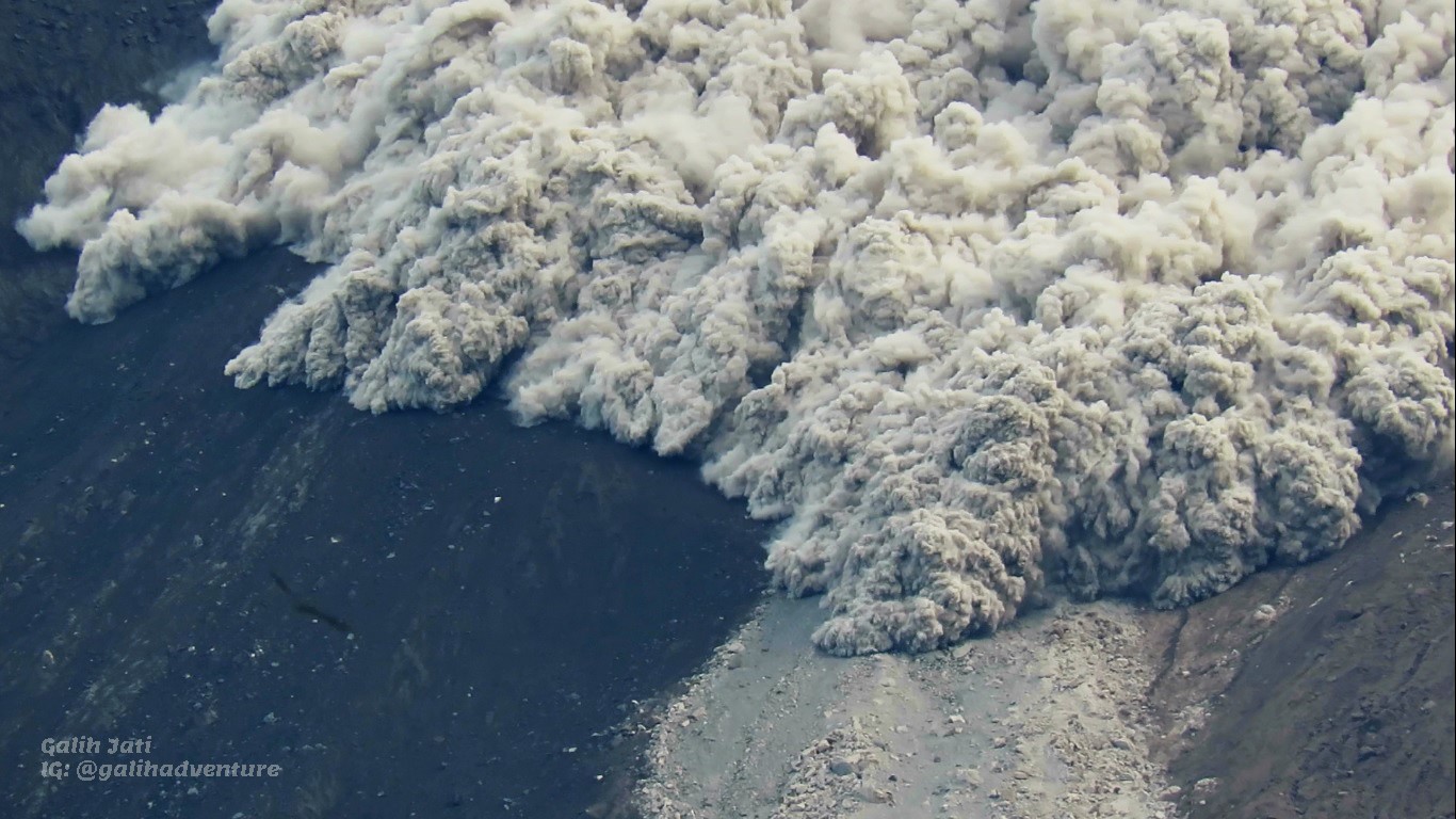
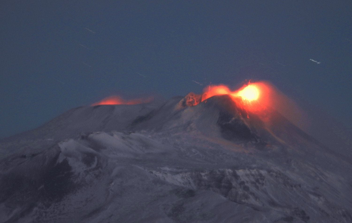
Indonesia , Merapi :
SIAGA activity level, Mount Merapi produces a series of hot avalanche clouds.
Since January 4, 2021, Mount Merapi has entered an effusive eruption phase, also known as the Merapi type, which is an eruption with activity in the form of lava dome growth, accompanied by lava avalanches and hot clouds.
“This Wednesday (01/27), from 00:00 to 14:00 WIB, Mount Merapi emitted 36 hot cloud avalanches with a sliding distance of between 500-3000 m towards the southwest or upstream of the Kali Krasak rivers and Boyong. Pyroclastic flows were recorded on the seismograms with an amplitude of between 15-60 mm and a duration of 83-197 seconds, ”said BPPTKG chief Hanik Humaida.
Due to the warm avalanche clouds, a number of places reported light to heavy ash rains, such as in Tamansari and Musuk districts, Boyolali district and several places in Klaten regency .
“Ash rains can occur as a result of hot cloud avalanches. For this reason, the community should anticipate disturbances from volcanic ash, for example by wearing masks, goggles and covering water sources, ”Hanik said of the ash rain that occurred in because of these hot cloud avalanches.
Hanik said the hot cloud sliding distance was still within the danger radius recommended by BPPTKG-PVMBG-Geological Agency, which is 5 km around the summit of Mount Merapi, towards the Boyong, Bedog, Krasak rivers, Bebeng, and Putih. The community is advised not to carry out activities in the recommended areas.
In addition, linked to the rainy season, the public is reminded to be aware of the dangers of lahars, especially when it rains at the top of Mount Merapi.
Regarding the current potential dangers, Hanik said, “The potential danger from the eruption of Mount Merapi comes in the form of lahars and hot clouds in the South-Southwest sector, which includes the Kali Boyong rivers, Bedog, Krasak, Bebeng and Putih with a maximum distance of 5 km from the summit. Meanwhile, explosive eruptions still have a chance to occur with eruption of volcanic material estimated to reach a radius of 3 km above the summit ”.
BPPTKG reported that the “2021 lava dome” continued to grow just below Merapi’s SW rim during 15-21 January, producing a total of 282 incandescent lava avalanches that traveled as far as 1 km down the Krasak and Boyong river drainages on the SW flank. Pyroclastic flows were recorded 19 times and descended the SW flanks as far as 1.8 km. A comparison of photos taken on 14 and 21 January showed that the morphological changes in the summit area were attributed to the emergence of new lava domes. The 2021 dome volume was an estimated 104,000 cubic meters on 21 January, with a growth rate of about 8,600 cubic meters per day. Deformation continued, though at a lower rate; Electronic Distance Measurement (EDM) data showed a distance shortening between points in the NW at a rate of 0.8 cm per day. Seismic activity was lower than the previous week. According to news articles ashfall was reported in several villages in the Musuk, Tamansari, and Kemalang districts on 19 January. The Alert Level remained at 3 (on a scale of 1-4), and the public were warned to stay 5 km away from the summit.
Sources : BPPTKG, GVP
Photo et video : Yohannes Tyas Galih Jati
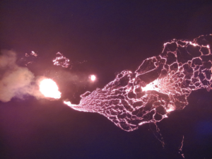
Italy / Sicily , Etna :
COMMUNIQUE ON VOLCANIC ACTIVITY of January 27, 2021, 10:31:57 (UTC) – ETNA.
The National Institute of Geophysics and Volcanology, Osservatorio Etnéo, reports that surveillance cameras observe that the activity produced by the summit craters remains unchanged from the last update. We note that the Strombolian activity of the Southeast Crater continues, fed by at least two explosive vents with deposition of products on the upper northeast flank of the cone, as well as the intracrater Strombolian activity in the northeast craters, Bocca Nuova and Voragine.
Photograph taken at dawn from Tremestieri Etnéo (South-South-East slope of Etna), with Strombolian activity at the eastern mouths and ′ ′ of the saddle ′ ′ of the South-East Crater on the right, and the gleams of the crater of the Bocca Nuova on the left
From the seismic point of view, from January 21, the average amplitude of the tremor remains in the high range showing a gradual increase, currently in progress. The location of the sources of the tremor remains confined to the area of the Southeast Crater at a depth of approximately 2900 m above mean sea level.

Image of the thermal surveillance camera on the Montagnola with Strombolian activity of the Southeast Crater on the right and of the Voragine crater on the left;
At the same time, infrasound activity located mainly in the Southeast Crater region continues. In particular, as of 07:30 UTC today there is a slight increase in both the number of events and their magnitude. The incline and GPS station data show no significant changes.
Further updates will be communicated shortly.
Source : INGV.
Photos : Boris Behncke , INGV.
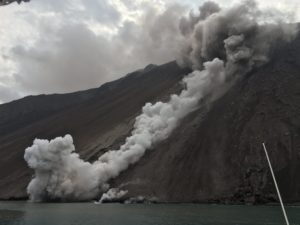
Saint Vincent , Soufrière Saint Vincent :
University of the West Indies Seismic Research Centre (UWI-SRC) and National Emergency Management Organisation (NEMO) reported that the lava dome in Soufrière St. Vincent’s main crater continued to grow during 20-26 January. Gas-and-steam plumes were often visible from Belmont Observatory, on Richmond Peak, about 6 km SSW of the crater. Another seismic station and a webcam became operational, and additional instrumentation was prepped.

Profile of the new dome with the older 1979 dome in the background for size comparison. The new dome is roughly 3/4 the height of the 1979 dome and is growing more or less equally in both directions (east to west). Estimated size as of 15/01/2021 is 340m (L) x 160m (W) x 90m (H). Helicopter reconnaissance over the next few days will allow scientists to obtain additional information on dome dimensions and volume.
Weather conditions sometimes prevented visual observations of the crater, though observations on 22 and 25 January confirmed that the previously-identified area of burnt vegetation had expanded, including towards the top of the E crater rim. During a monitoring visit on 24 January scientists took video and still photos of the dome and installed both a camera and an EDM reflector on the S crater wall. The Alert Level remained at Orange (the second highest level on a four-color scale).
Sources : Nemo , GVP.
Photo : Dr Thomas Christopher.
Japan , Kuchinoerabujima :
JMA lowered the Alert Level for Kuchinoerabujima to 2 (the second lowest level on a scale of 1-5) on 19 January, noting downward trends in activity data since mid-2020. Specifically, after May 2020 no volcanic earthquakes were detected, inflation slowed to baseline levels, and sulfur dioxide emissions began decreasing though remained slightly high. Additionally, crater incandescence had not been visible after July and no eruptions were recorded after August 2020.
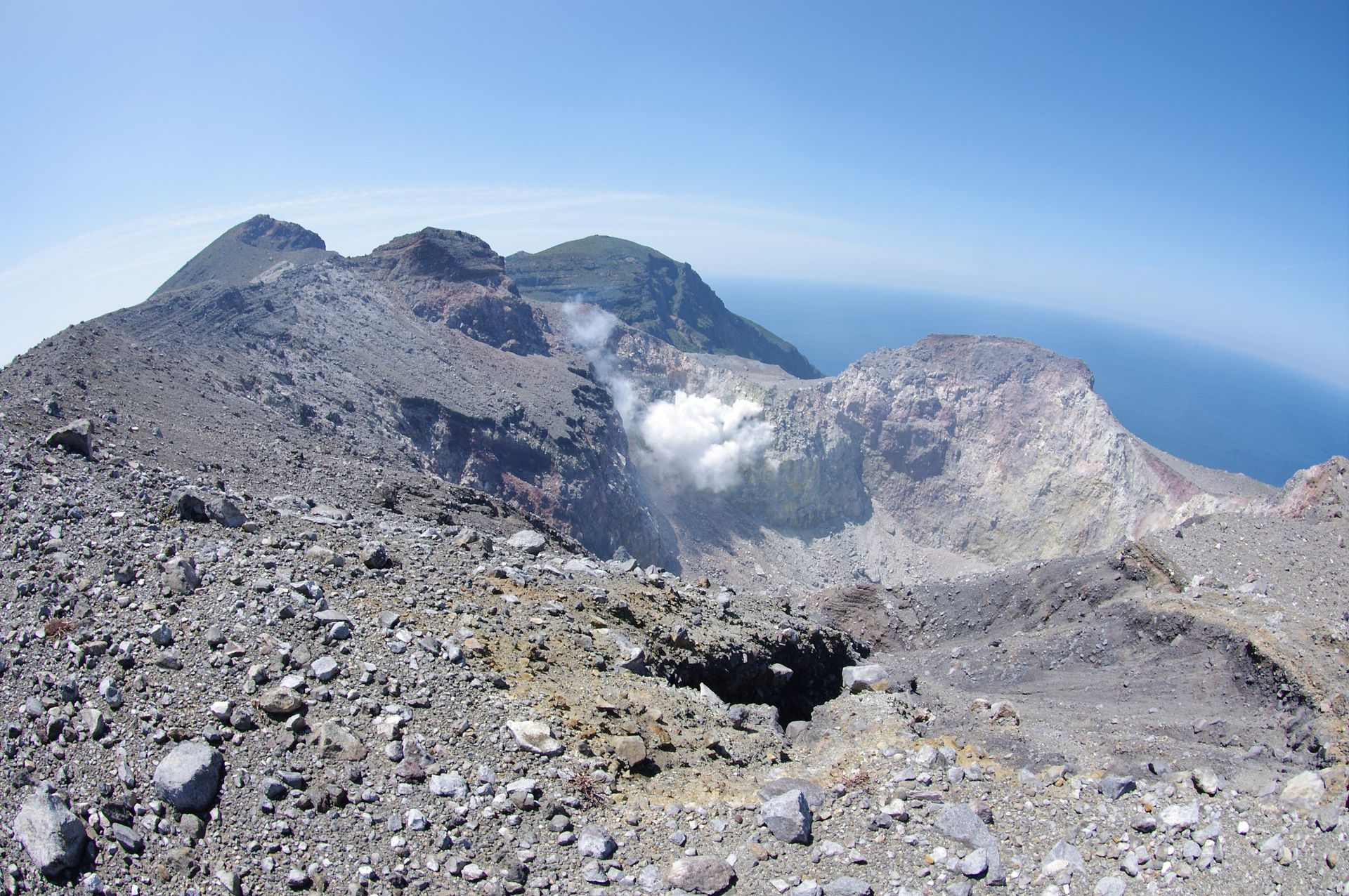
A group of young stratovolcanoes forms the eastern end of the irregularly shaped island of Kuchinoerabujima in the northern Ryukyu Islands, 15 km W of Yakushima. The Furudake, Shindake, and Noikeyama cones were erupted from south to north, respectively, forming a composite cone with multiple craters. All historical eruptions have occurred from Shindake, although a lava flow from the S flank of Furudake that reached the coast has a very fresh morphology. Frequent explosive eruptions have taken place from Shindake since 1840; the largest of these was in December 1933. Several villages on the 4 x 12 km island are located within a few kilometers of the active crater and have suffered damage from eruptions.
Source : GVP.
Photo : Tsuda — Flickr: Kuchino-erabu island (volcano), CC BY-SA 2.0, https://commons.wikimedia.
Colombia , Nevado del Ruiz :
Nevado del Ruiz volcano activity level bulletin.
The activity level continues at Yellow Activity Level or (III): changes in the behavior of volcanic activity.
Regarding the monitoring of the activity of the Nevado del Ruiz volcano, the COLOMBIAN GEOLOGICAL SERVICE reports that:
The seismicity generated by the fracturing of the rock increased, in number of earthquakes and in seismic energy released, compared to the previous week. This seismic activity was located mainly in the North-East sector of the volcano, and to a lesser extent and in a dispersed manner, a seismicity of this type was recorded in the South-East, South, North sectors of the Arenas crater. The depths of the earthquakes ranged from 1.1 to 6.6 km. The highest magnitude recorded during the week was 1.4 ML (local magnitude), which corresponds to the earthquake that occurred on January 20 at 1:18 p.m. local time, located 1.9 km north -Is at a depth of 4.1 km.
The seismicity linked to the dynamics of the fluids inside the volcanic conduits decreased, in number of events and in seismic energy released, compared to the previous week. This seismic activity was characterized by the occurrence of continuous volcanic tremor, tremor pulses, long and very long period type earthquakes, which presented variable energy levels and spectral content.
The deformation of the volcanic surface, measured from GNSS (Global Navigation Satellite System) stations and electronic inclinometers, has changed slightly towards the Olleta sector.
Source : SGC .
Photo : Diana M Bustamante.