October 11 , 2022 .
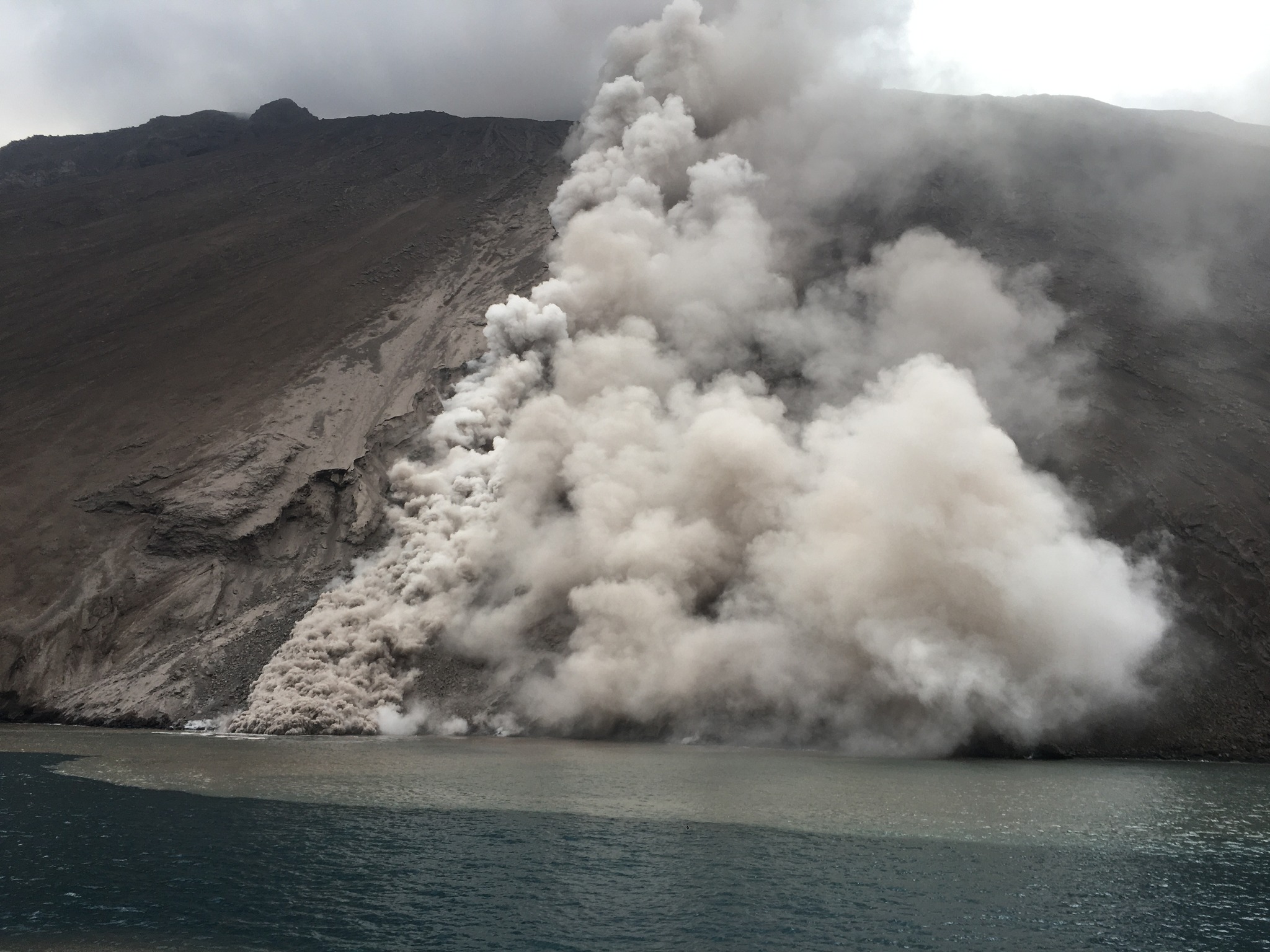
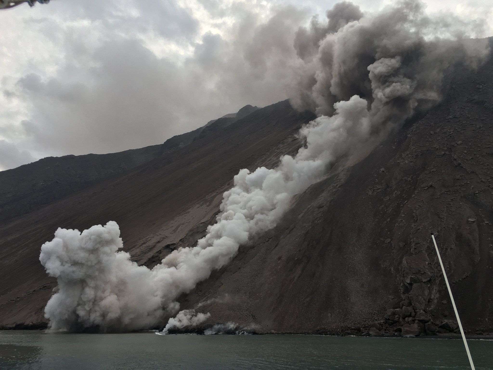
Italy , Stromboli :
Press release on the activity of STROMBOLI, October 10, 2022, 09:19 (07:19 UTC).
The National Institute of Geophysics and Volcanology, Osservatorio Etneo, reports that modest collapses were observed overnight, likely due to erosion from overlapping lava flow channels. Field observations by INGV staff show that the collapses and lava flows continue, poorly fed, no longer reaching the sea and settling in the middle of the slope at an altitude of about 400 m.
Even from the partial and discontinuous images of the surveillance cameras, mainly due to unfavorable weather conditions, it can be observed that the flow supply has decreased.
From the seismic point of view, during the last 24 hours, the average amplitude of the volcanic tremor showed various fluctuations, oscillating mainly in the medium-low and medium-high levels, and reached the level of the high values between 10:00 a.m. and 11:00 a.m. UTC and around 4:30 p.m. UTC yesterday. Currently, the magnitude of the tremor is in the medium-low level.
The recorded seismograms show the presence of point signals possibly associated with the rolling of materials.
Data from deformation monitoring networks on the island show no significant changes since the last publication, except for some transients in the signal from the Timpone del Fuoco inclinometer station yesterday coinciding with the increase in volcanic tremor .
Press release on the activity of STROMBOLI, October 10, 2022, 23:48 (21:48 UTC).
The National Institute of Geophysics and Volcanology, Osservatorio Etneo, announces that according to ground observations made by INGV staff in the evening, it appears that the eruptive scenario described in the previous press release remains almost unchanged. Indeed, the lava flows continue to be poorly fed and the fronts have not advanced, settling at about 400 m altitude. Frequent collapses and detachments of material from the lava channel eroded by the flows and from the front itself which quickly reach the sea continue to be observed.
From the seismic point of view, during the last hours, the average amplitude of the volcanic tremor showed various fluctuations in the medium-low and medium-high levels and is currently located in the medium-low level.
Compared to the last update announcement, the Timpone del Fuoco inclinometer station signal recorded a variation beginning around 2:30 p.m. GMT which gradually built up by about 0.2 microradians at 3:30 p.m. GMT and then returned to the level normal at the time of publication of this press release.
Further updates will be communicated soon.
Source : INGV.
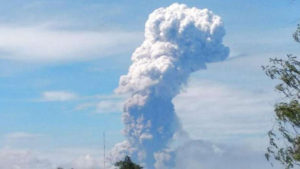
Philippines , Mayon :
MAYON VOLCANO BULLETIN 11 October 2022 8:00 AM
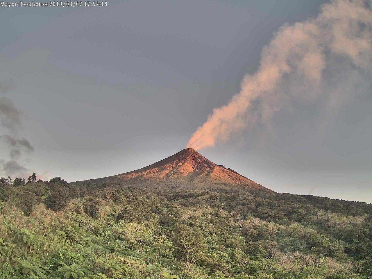
In the past 24-hour period, the Mayon Volcano Network recorded one (1) volcanic earthquake. Moderate emission of white steam-laden plumes that drifted southwest was observed. Sulfur dioxide (SO2) emission was last measured at an average of 391 tonnes/day on 01 October 2022. Based on ground deformation parameters from EDM, Precise Leveling, electronic tilt and continuous GPS monitoring, Mayon Volcano has been slightly inflated since 2020.
Alert Level 2 (Increased Unrest) prevails over Mayon Volcano. The public is reminded that there is current unrest driven by shallow magmatic processes that could eventually lead to phreatic eruptions or even precede hazardous magmatic eruption. Entry into the six (6) kilometer-radius Permanent Danger Zone (PDZ) is strictly prohibited to minimize risks from sudden explosions, rockfall and landslides. In case of ash fall events that may affect communities downwind of Mayon’s crater, people should cover their nose and mouth with damp, clean cloth, or dust mask. Civil aviation authorities must also advise pilots to avoid flying close to the volcano’s summit as ash from any sudden eruption can be hazardous to aircraft. DOST-PHIVOLCS maintains close monitoring of Mayon Volcano and any new development will be communicated to all concerned stakeholders.
Source : DOST-PHIVOLCS
Photo : Mayon Resthouse via Volcanodiscovery.
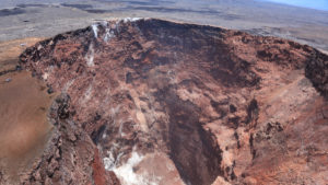
Peru , Sabancaya :
Analysis period: from October 03, 2022 to October 09, 2022, Arequipa, October 10, 2022.
Alert level: ORANGE
The Geophysical Institute of Peru (IGP) reports that the eruptive activity of the Sabancaya volcano remains at moderate levels, that is to say with the recording of an average of 45 daily explosions, with columns of ash and gas up to 3.0 km altitude above the summit of the volcano and their consequent dispersion. Therefore, for the following days, no significant change is expected in eruptive activity.
The IGP recorded and analyzed the occurrence of 342 earthquakes of volcanic origin, associated with the circulation of magmatic fluids inside the Sabancaya volcano. An average of 45 explosions was recorded daily, in addition to recording Volcano-Tectonic (VT) type events associated with rock fracturing inside the Sabancaya volcano.
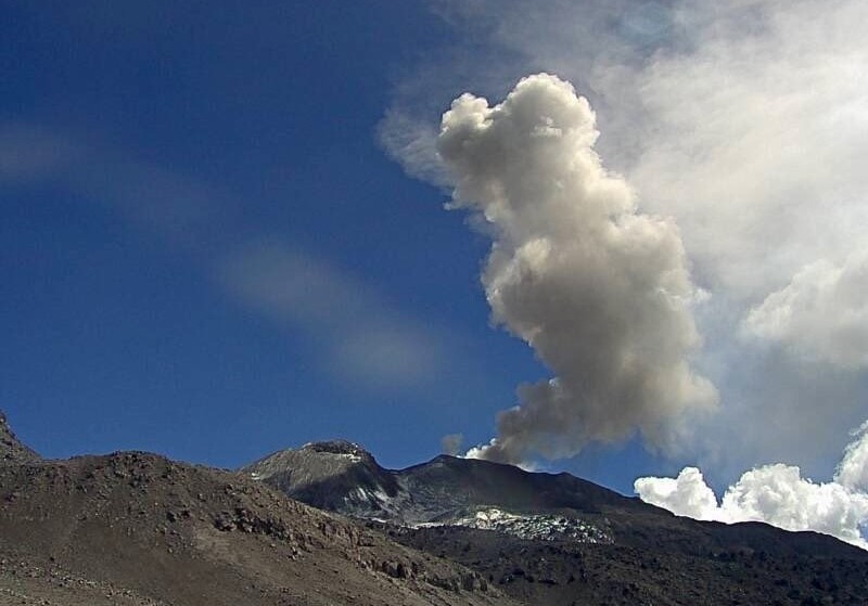
Monitoring the deformation of the volcanic structure using GNSS techniques (processed with fast orbits) does not show any significant anomalies. However, in general, an inflation process was observed in the northern sector (surroundings of the Hualca Hualca volcano). Visual surveillance identified columns of gas and ash up to 3.0 km above the summit of the volcano, which were dispersed towards the east, west and northeast sectors of Sabancaya. Satellite recordings have identified the presence of 9 thermal anomalies, with a maximum value of 16 MW, associated with the presence of a lava body on the surface of the volcano’s crater.
RECOMMENDATIONS
• Keep the volcanic alert level orange.
• Do not approach within a radius of less than 12 km from the crater.
Source : Cenvul
Photo : Ingemmet.
New Zealand , Lake Taupo :
Minor volcanic unrest continues at Taupō Volcano, with ongoing earthquakes and ground deformation. The Volcanic Alert Level for Taupō Volcano remains at 1 (minor volcanic unrest).
The earthquakes and deformation at Lake Taupō have continued since the last bulletin on 28 September 2022. The rate of earthquake activity has varied since May, peaking with over 80 events in a week in early September. The currently weekly rate has dropped noticeably from a plateau of about 20-40 events a week from June to September. Meanwhile our GNSS (GPS) instruments around the lake continue to observe uplift since May at a site on Horomatangi Reef in the centre of the lake.
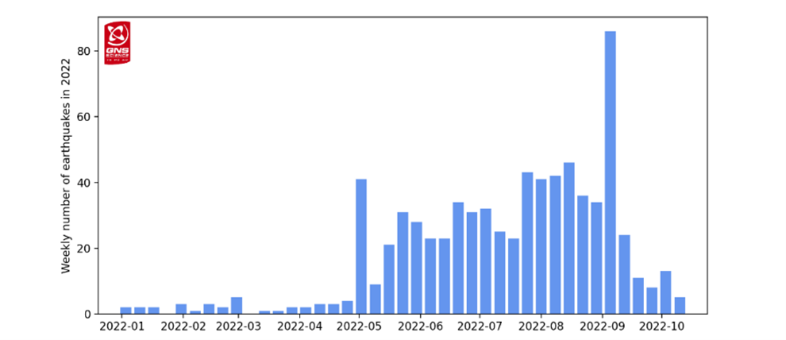
Figure 1: Number of earthquakes detected and located beneath Lake Taupō each week since the start of 2022.
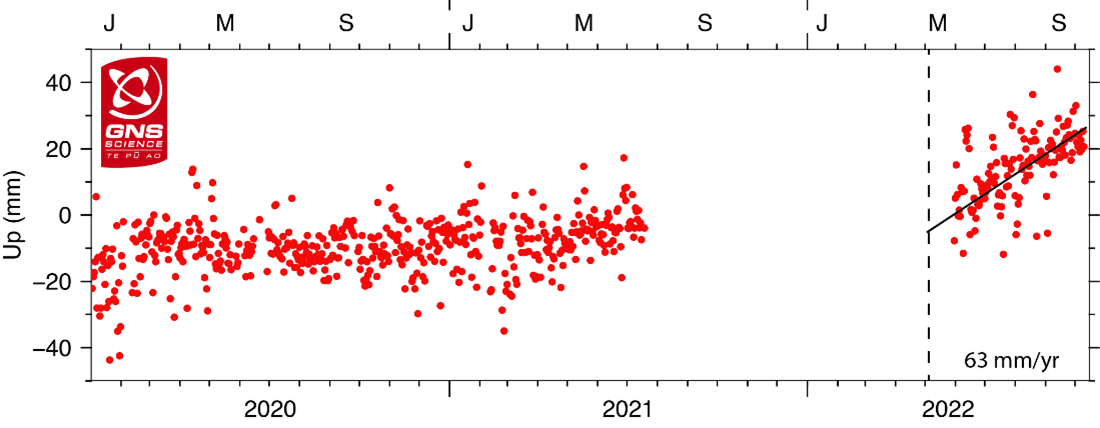
Figure 2: GNSS ground uplift observed at Horomatangi Reef in central Lake Taupō since 2020. The observations represent daily elevations. The scatter in the observations reflects the uncertainty in the calculated daily elevations. The GNSS at Horomatangi Reef was not operating from mid-2021 to mid-2022.
We have now located 746 earthquakes, mainly at a depth of 4 to 13 km beneath the centre of Lake Taupō since the activity began in May 2022. The earthquakes in the last 2 weeks have been concentrated in the eastern part of the lake. The largest was magnitude 3.3 on October 3. Shown in Figure 1 is the number of earthquakes detected beneath Lake Taupō each week since early 2022.
In addition to seismic activity, GeoNet continuously monitors ground deformation (land movement) around Lake Taupō. Our GNSS (GPS) instruments around the lake continue to observe uplift at a rate of approximately 60 ± 20 mm per year since May 2022 at a site on Horomatangi Reef in the centre of the lake (Figure 2). An independent survey of vertical ground movement around the lake shore on 28 September shows that the Horomatangi Reef area had risen 24 mm since February 2022. This independent verification of analysis of GNSS data gives us a lot of confidence in our ground deformation results.
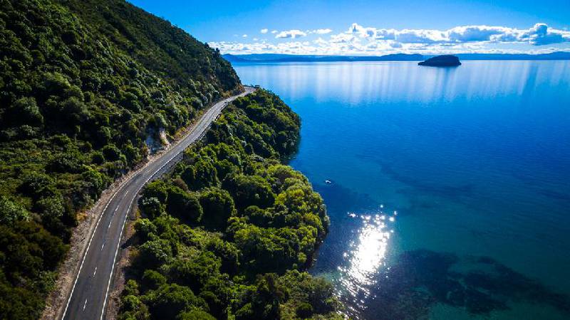
Aerial view of Lake Taupō.
We interpret the ground uplift and earthquake activity to be caused by the movement of magma and the hydrothermal fluids inside the volcano. This activity could continue for the coming weeks or months at varying rates or intensities. While some of the earthquakes may be felt in areas around Lake Taupō, the deformation is currently only detectable by our sensitive ground-based monitoring instruments.
Volcanic unrest is when magma or magma-heated hot water and steam forces its way through the ground beneath a volcano, producing earthquakes and ground movement. There have been 17 previous episodes of unrest at Taupō over the past 150 years and none have ended in an eruption
Source : Geonet.
Photos : Geonet , Istock.com via 1news.co.nz.
Guatemala , Santiaguito :
Activity:
A cloudy environment is reported, the seismic stations record periods of degassing and some weak explosions which, in clear weather, are observed as a column of water vapor. Weak and moderate avalanches continue to be recorded at the front and in the middle of the lava flow towards the San Isidro and El Tambor channels, as well as on the southern flank. Along the path of this lava flow, vapor emanations are observed due to its high temperature by observing the front of the flow with degassing. It is recommended not to approach the lava flow, due to the intense heat it emits and the constant collapses that occur on its edges, which could cause burns and other serious injuries to those who come close. The volcano maintains high activity due to blocky lava extrusion within the dome of Dome Caliente in a west-southwest direction and unstable material within the crater. There is a likelihood of moderate to strong pyroclastic flows, so do not stay near or in riverbeds near the slopes of the volcano.

Building on the forecasts and updates the Department of Meteorological Research and Services is doing for Hurricane Julia, which predicts that this tropical cyclone will produce widespread rainfall across the country and in particular over the Volcanic Arc at From Sunday and Monday, the Volcanology section reports the threat of the descent of the lahars.
On other occasions, the passage of hurricanes and tropical storms has produced the descent of lahars on the volcanoes of Fuego, Santa María-Santiaguito, Agua, Atitlán and Tolimán after the rains left by events such as Stan and Ágatha. The ravines on the slopes of these volcanic buildings contain deposits of boulders and ash produced by pyroclastic flows from recent and ancient eruptions.
Because forecasts estimate that Hurricane Julia will leave accumulated precipitation greater than 100 mm, it is important to consider that these intense rains can produce lahars on the volcanoes already mentioned, causing direct impacts on certain communities, roads and bridges, in addition to causing flooding in the rivers that descend from these volcanoes, making it impossible to cross them, and that the material they leave deposited behind them prevents the passage of vehicles for hours or days after the event. This can leave communities cut off by blocking passage through their usual transit or evacuation routes.
Source : Insivumeh
Photo : Annie Winson , earthobservatory.sg