October 14 , 2023.
Colombia , Galeras :
Galeras Volcano Weekly Activity Bulletin
From the monitoring of the activity of the GALERAS VOLCANO, the MINISTRY OF MINES AND ENERGY through the COLOMBIAN GEOLOGICAL SERVICE (SGC) reports that:
For the period from October 3 to 9, 2023 and compared to the previous week, the seismic activity showed an increase in the frequency of events, predominating those related to the fracturing of rocks within the volcanic system. Localized earthquakes were mainly grouped into two regions. A source near the volcanic cone, at distances up to 1.3 km and depths less than 3 km (relative to the datum of 4,200 m above sea level), with a maximum magnitude of 1, 2. The other source was located 5.2 km west of the cone, at depths between 5.8 and 7.2 km (relative to the reference level of 4,200 m altitude) and with a maximum magnitude of 1. None of these earthquakes were reported as felt by residents in the area.

Atmospheric conditions were favorable for capturing images of the volcanic cone, where small gas emissions were evident from the El Paisita and Las Chavas fumarole fields, located to the north and southwest of the active cone, respectively, with columns very low in height, white and variable dispersion due to the action of the wind.
The state of alert for volcanic activity remains at:
YELLOW ALERT: Active volcano with changes in the behavior of the base level of monitored parameters and other manifestations.
Source et photo : SGC
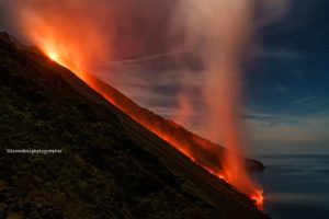
Iceland , Reykjanes Peninsula :
Chances have increased that a new magmatic dike will form beneath Fagradalsfjall
Measurements show acceleration of uprising, October 13, 2023
Signs of uplift on the Reykjaness Peninsula were measured shortly after Litli Hrútur’s eruption ended in early August this summer. The situation is similar to what it was before the July 10 eruption, which lasted about 4 weeks. The latest GPS measurements now show an acceleration of the movement.
Early models based on satellite data indicate that the expansion can be attributed to magma accumulating at a depth of around 10 km. The process currently underway is similar to that observed during previous magmatic intrusions at Fagradalsfjall. Additionally, data shows that the rate of deformation has increased in recent weeks.
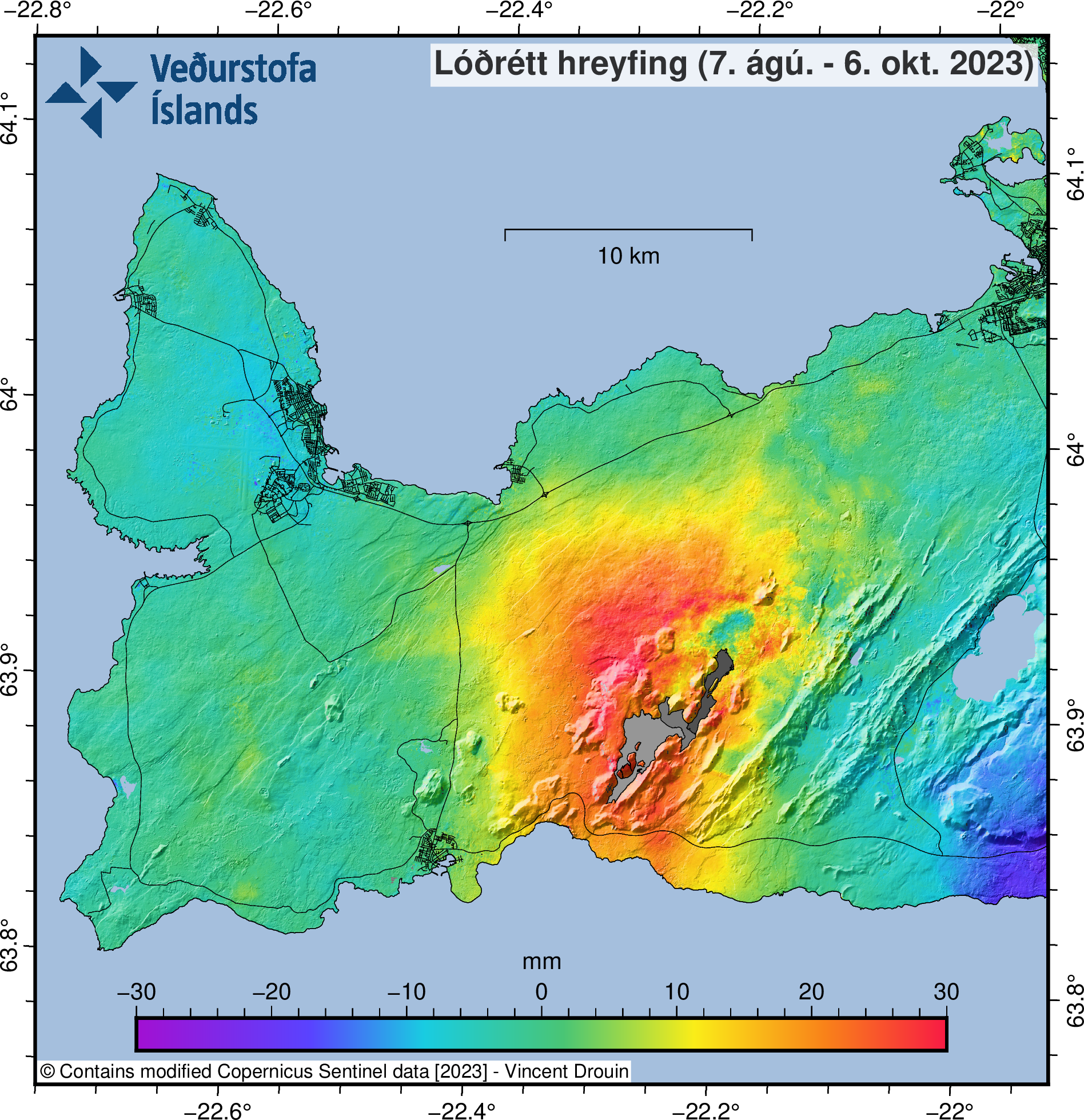
Image showing the near-vertical movement between August 7 and October 6, 2023. The image is derived from Sentinel-1 satellite data (InSAR).
The chances of a new magmatic dike forming beneath Fagradalsfjall have increased and this could happen in the coming weeks or months. This would cause seismic activity as magma forces its way through fragile parts of the Earth’s crust which could eventually erupt.
Around 520 earthquakes were recorded on the Reykjanes Peninsula last week, and so far this week more than 220 earthquakes have been recorded. Last week, two earthquakes of magnitude greater than 3 were measured, one of magnitude 3.3 west of Kleifarvatn and the other of magnitude 3.2 about 5 km northeast of Grindavík. Before the Fagradalsfjall eruptions in 2022 and in the summer of 2023, thousands of earthquakes were measured a few days before the start of the eruption, when the magma corridor was approaching the surface.
Source et photo : IMO.
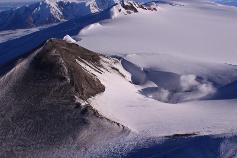
Alaska , Wrangell :
AVO/USGS Volcanic Activity Notice
Current Volcano Alert Level: UNASSIGNED
Previous Volcano Alert Level: NORMAL
Current Aviation Color Code: UNASSIGNED
Previous Aviation Color Code: GREEN
Issued: Friday, October 13, 2023, 10:44 AM AKDT
Source: Alaska Volcano Observatory
Notice Number: 2023/A1495
Location: N 62 deg W 144 deg 1 min
Elevation: 14163 ft (4317 m)
Area: Wrangell Volcanic Field
Volcanic Activity Summary:
Due to a station outage, the Alaska Volcano Observatory (AVO) has lost the capability to monitor Mount Wrangell volcano seismically and cannot reliably detect changes in unrest at the volcano. AVO is moving the Volcano Alert Level and Aviation Color Code of Mount Wrangell to UNASSIGNED. As at other Alaska volcanoes, AVO will continue using satellite, regional infrasound, lightning data, and reports from pilots and ground observers to detect signs of eruptive activity should they occur.
Remarks:
Mt. Wrangell is a 4317 m (14,163 ft) high, andesitic, shield volcano with an ice-filled summit caldera, located in the Wrangell-St. Elias National Park and Preserve. Mt. Wrangell has three small post-caldera craters, named North Crater, East Crater, and Mt. Zanetti. These craters are all geothermally active, and there are frequent historical reports of steam from Mt. Wrangell. There are also several questionable reports of historical eruptive activity. Mt. Wrangell is 330 km (206 mi) northeast of Anchorage.
Source : AVO
Photo : Claus, Paul
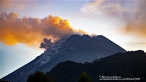
Indonesia , Merapi :
Report on the activity of Mount Merapi from October 6, 2023 to October 12, Published on October 14, 2023.
OBSERVATION RESULTS
Visual
The weather around Mount Merapi is generally sunny in the morning and afternoon, while the evening is foggy. White smoke, fine to thick, low to medium pressure and 300 m high was observed from the observation post of Mount Merapi in Badaban on October 7, 2023 at 5:23 a.m.
This week, lava avalanches were observed 177 times towards the South and Southwest, including 18 times upstream of the Boyong River up to 1600 m and 145 times upstream of the Bebeng River up to a maximum of 2000 m. The sound of avalanches was heard 31 times from the Babadan post with low to moderate intensity.
Based on the analysis of aerial photos from September 28, 2023, the volume of the southwest dome was measured at 3,097,700 cubic meters and that of the central dome at 2,358,500 cubic meters.
Seismicity
This week, the seismicity of Mount Merapi showed:
24 shallow volcanic earthquakes (VTB),
2135 multi-phase (MP) earthquakes,
943 avalanche earthquakes (RF)
11 tectonic earthquakes (TT).
The intensity of seismicity this week is lower than last week, but the number of earthquakes is still quite high.

Deformation
The deformation of Mount Merapi that was monitored using EDM this week showed a shortening of steepening distance by 0.5 cm/day.
Rain and lahars:
There was no rain this week at Pengamatan’s Mount Merapi lookout post. There have been no reports of additional flows or lahars from rivers flowing down from Mount Merapi.
Conclusion
Based on the results of visual and instrumental observations, it is concluded that:
-Mount Merapi’s volcanic activity is still quite high in the form of effusive eruption activity. The activity status is defined at the “SIAGA” level.
The current danger potential is in the form of lava avalanches and hot clouds in the South-South-West sector including the Boyong river for a maximum of 5 km, the Bedog, Krasak, Bebeng rivers for a maximum of 7 km. In the South-East sector, it includes the Woro river for a maximum of 3 km and the Gendol river for 5 km. While the ejection of volcanic material in the event of an explosive eruption can reach a radius of 3 km from the summit.
Source : BPPTKG
Photo : imamismadin
Hawaii , Kilauea :
Friday, October 13, 2023, 9:20 AM HST (Friday, October 13, 2023, 19:20 UTC)
19°25’16 » N 155°17’13 » W,
Summit Elevation 4091 ft (1247 m)
Current Volcano Alert Level: ADVISORY
Current Aviation Color Code: YELLOW
Activity Summary:
Kīlauea volcano is not erupting. The area just south of Kīlauea’s summit is showing signs of episodic heightened unrest. An eruption is not imminent, but one could occur in the region from Halemaʻumaʻu south to the December 1974 vents with little notice (1-2 hours). No unusual activity has been noted along Kīlauea’s East Rift Zone or Southwest Rift Zone.

Summit Observations:
Episodic heightened unrest continues in the south summit area of Kīlauea. Inflation at the summit of Kīlauea remains high and has nearly returned to the level seen just before the last eruption on September 10th.
The Uēkahuna summit tilt meter located north of the caldera recorded a flat trend over the past 24 hours. The Sand Hill tilt meter, located just south of the caldera, is also displaying a flat tilt trend. GPS units within the south end of the caldera and further south show continued uplift of this region. Elevated basicity is being recorded beneath the south end of Kīlauea caldera and extends to the southwest along the trend of December 1974 vents. A map summarizing the recent activity is located here: October 12, 2023—Summary map of intrusive activity at Kīlauea Volcano―October 4–12, 2023 | U.S. Geological Survey (usgs.gov)
Over the past 24 hours, approximately 21 earthquakes were recorded in Kīlauea summit region. Most of the earthquakes from the seismic swarm south of the caldera are at depths of around 0–4 km (0.6–3 mi) below the surface. Sulfur dioxide (SO2) emission rates remain low and were measured at a rate of about 100 tonnes per day on October 6.
Source : HVO
Photo : USGS/ M. Zoeller.