November 27 , 2020.
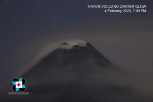
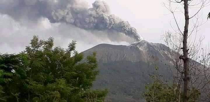
Indonesia , Sinabung :
The activity level has been at level III (SIAGA) since May 20, 2019 at 10:00 a.m. WIB. The Sinabung volcano (2460 m altitude) has been erupting since 2013.
The volcano was clearly visible until it was covered in fog. The crater emits white smoke with a strong thickness, which rises about 50 to 300 meters above the summit. The weather is sunny to cloudy, with light to moderate winds in the South, South-West and West. The air temperature is around 16-25 ° C.
According to the seismographs of November 25, 2020, it was recorded:
1 eruption / explosion earthquake
53 avalanche earthquakes
5 emission earthquakes
14 low frequency earthquakes
31 hybrid / multi-phase earthquakes
17 local tectonic earthquakes
3 distant tectonic earthquakes.

VOLCANO OBSERVATORY NOTICE FOR AVIATION – VONA
Issued : November 25 , 2020
Volcano : Sinabung (261080)
Current Aviation Colour Code : ORANGE
Previous Aviation Colour Code : orange
Source : Sinabung Volcano Observatory
Notice Number : 2020SIN32
Volcano Location : N 03 deg 10 min 12 sec E 98 deg 23 min 31 sec
Area : North Sumatra, Indonesia
Summit Elevation : 7872 FT (2460 M)
Volcanic Activity Summary :
Eruption with volcanic ash cloud at 10h34 UTC (17h34 local).
Volcanic Cloud Height :
Best estimate of ash-cloud top is around 9472 FT (2960 M) above sea level, may be higher than what can be observed clearly. Source of height data: ground observer.
Other Volcanic Cloud Information :
Ash-cloud moving to south – west.
Remarks :
Seismic activity is characterized by eruption volcanic event.
PVMBG reported that at 13h44 on 18 November an eruptive event at Sinabung generated an ash plume that rose 1 km above the crater rim and drifted SW. At 21h37 on 21 November seismic data indicated an emission, though weather conditions prevented visual confirmation. The Alert Level remained at 3 (on a scale of 1-4), with a general exclusion zone of 3 km and extensions to 5 km in the SE sector and 4 km in the NE sector.
Source : PVMBG , Magma Indonésie, GVP .
Photo : Nachelle Homestay .
Indonesia , Ili Lewotolok :
VOLCANO OBSERVATORY NOTICE FOR AVIATION – VONA
Issued : November 26 , 2020
Volcano : Ili Lewotolok (264230)
Current Aviation Colour Code : ORANGE
Previous Aviation Colour Code : unassigned
Source : Ili Lewotolok Volcano Observatory
Notice Number : 2020LEW01
Volcano Location : S 08 deg 16 min 19 sec E 123 deg 30 min 18 sec
Area : East Nusa Tenggara, Indonesia
Summit Elevation : 4554 FT (1423 M)
Volcanic Activity Summary :
Eruption with volcanic ash cloud at 21h57 UTC (05h57 local). Eruption and ash emission is still continuing
Volcanic Cloud Height :
Best estimate of ash-cloud top is around 6154 FT (1923 M) above sea level, may be higher than what can be observed clearly. Source of height data: ground observer.
Other Volcanic Cloud Information :
Ash-cloud moving to west
Remarks :
Seismic activity is characterized by continuous volcanic tremor
G. Ili Lewotolok eruption press release, November 27, 2020 at 5:57 am WIT.
The activity level of G. Ili Lewotolok has been at the WASPADA alert level (level II) since October 7, 2017.
Surveillance data:
Seismic data for the last three months (up to November 26, 2020) has been recorded as stable with a daily average of 1 emission earthquake, 2 shallow volcanic earthquakes, 1 local tectonic earthquake and 1 tremor of deep tectonic earth. For other earthquakes, an average of less than one event was recorded per day.
Analysis:
The chronology of the eruption of G. Ili Lewotolok on November 27, 2020 at 5:57 a.m., began with the recording of a deep volcanic earthquake (VA) on November 26, 2020 at 7:47 p.m., then again recorded successively at 7:51 p.m., 7:52 p.m., 7:53 p.m. and at 10:55 p.m.
On November 27, 2020, a deep volcanic earthquake was recorded at 2:42, 5:37 and 5:56, as well as a local tectonic earthquake at 4:11. Then the eruption started at 5:57 a.m. The eruption tremors were recorded until 7:50 am with a tremor amplitude of 2-3 mm (dominant value 2 mm).
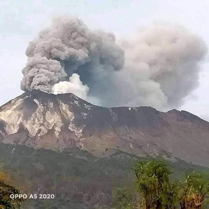
Smoke from the eruption was observed with a thick consistency, a gray-black color with a column of smoke rising about 500 meters above the peak and blown westward. The smoke turned white again with thick intensity since around 6.30am on November 27, 2020 with a smoke height of around 500 meters above the peak.
With current seismic and visual data, the activity of Mount Ili Lewotolok is classified as high and has the potential for subsequent eruptions.
Potential danger:
The potential dangers of Mount Ili Lewotolok are in the form of flying stones (incandescent) and heavy ash rains within a radius of 2 km around the summit (risk zone III). Falling ash can potentially reach other areas depending on the direction and speed of the wind.
Other potential dangers are avalanches / collapses of weathered material from the upper part of the intrusion, the volume of which is estimated at around 400,000 m3 in the South-East. In addition, there are potential dangers of toxic volcanic gases such as CO2, CO and SO2 in the summit area of Mount Ili Lewotolok.
Conclusion:
The activity level of G. Ili Lewotolok is currently on WASPADA alert (level II).
Source : PVMBG , Magma Indonésie,
Photos : Kodi Setiawan .
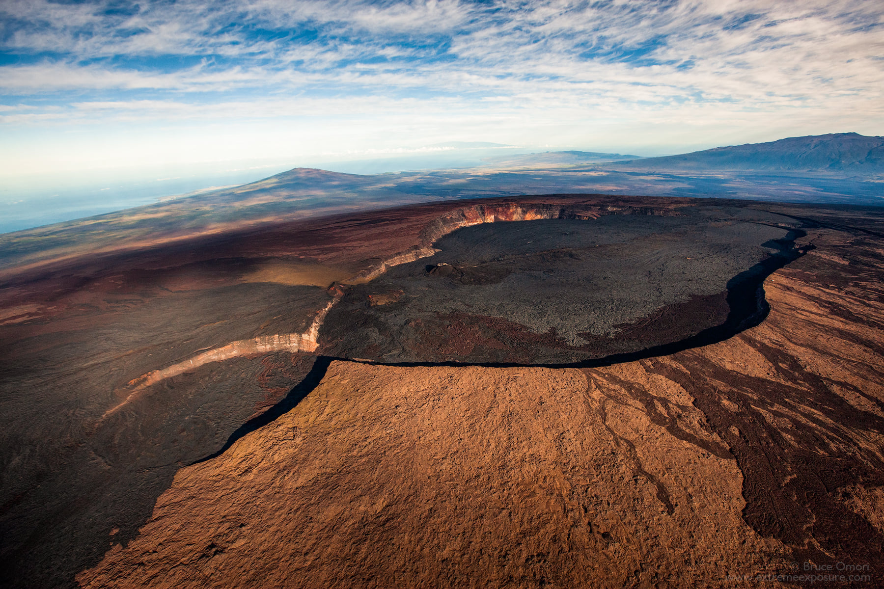
Hawaii , Mauna Loa :
19°28’30 » N 155°36’29 » W,
Summit Elevation 13681 ft (4170 m)
Current Volcano Alert Level: ADVISORY
Current Aviation Color Code: YELLOW
Activity Summary:
Mauna Loa Volcano is not erupting. Rates of deformation and seismicity have not changed significantly over the past week and remain above long-term background levels.
Observations:
During the past week, HVO seismometers recorded 136 small-magnitude earthquakes across the whole volcano, 91 of which were under the volcano’s summit and upper-elevation flanks, including a cluster in the volcano’s west flank. Most of these earthquakes occurred at shallow depths of less than 8 kilometers (~5 miles) below ground level.
Global Positioning System (GPS) measurements show overall continued slow summit inflation, consistent with magma supply to the volcano’s shallow storage system.
Gas concentrations and fumarole temperatures at both the summit and Sulphur Cone on the Southwest Rift Zone remain stable.
Webcam views have revealed no changes to the landscape over the past week.
Source : HVO.
Photo : Bruce Omori .
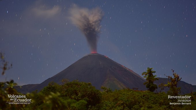
Ecuador , Reventador :
DAILY REPORT OF THE STATE OF THE REVENTADOR VOLCANO, Friday November 26, 2020.
Information Geophysical Institute – EPN.
Surface activity level: High, Surface trend: Increasing.
Internal activity level: High, Internal trend: No change.
Seismicity: From November 25, 2020, 11:00 a.m. to November 26, 2020, 11:00 a.m.
Explosions (EXP): 55 events.
Long periods (LP): 60 events.
Emission tremor (TE): 2 events.
Harmonic tremor (TA): 3 events.
Rains / lahars: No rains were recorded in the area.
Ash Emission / Column: During the afternoon of yesterday and early today, several emissions of gas, vapor and ash were observed with heights between 800 and 1000 m above the level from the crater, mainly in a north-west and north-east direction
Other monitoring parameters: Concerning thermal anomalies: MIROVA reports 2 moderate alerts and 1 low during the last 24 hours.
Observations: During the night of yesterday, the emission of incandescent materials produced by the explosions was observed; as well as the rolling of blocks on all sides of the volcano. The lava flow is still active (~ 450 m) in the northeast and without notable changes.
Alert level: Orange.
IG reported that a high level of activity continued to be recorded at Reventador during 17-24 November. Seismicity was characterized by explosions, volcano-tectonic and harmonic tremor events, and long-period earthquakes as well as signals indicating emissions. Gas, steam, and ash plumes, observed sometimes multiple times a day with the webcam or reported by the Washington VAAC, rose as high as 1.3 km above the summit crater and drifted mainly NW, W, and SW. Crater incandescence and incandescent blocks rolling 600 m down the NE and S flanks were observed during 17-21 and 23-24 November. The 450-m-long lava flow on the NE flank remained active but did not advance.
Source : IGEPN , GVP.
Photo : Benjamin Bernard .