April 10 , 2022.
Costa Rica , Poas / Rincon de la Vieja / Turrialba :
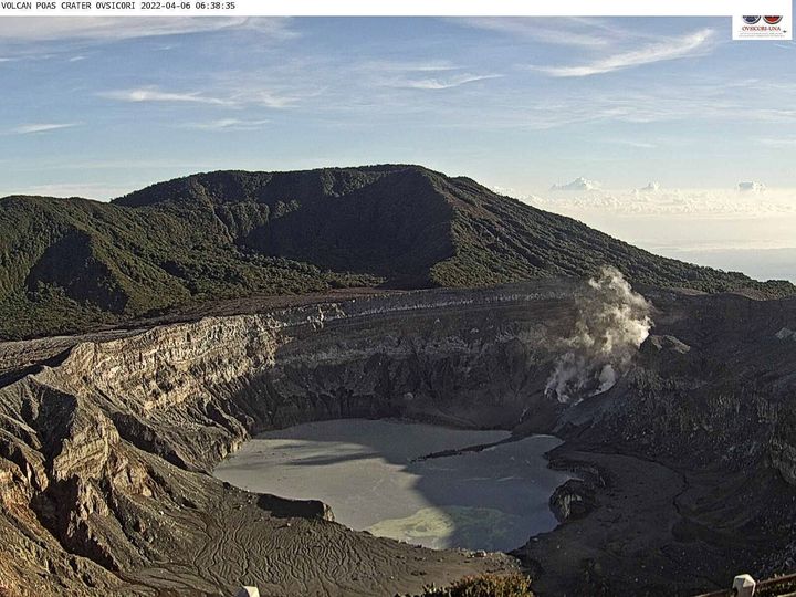
Poas Volcano
Latitude: 10.2°N;
Longitude: 84.233°W;
Altitude: 2780m
Current activity level: 3 (volcanic eruption)
Potentially associated dangers: gas, phreatic eruptions, ballistic projections, acid rain, lahars.
On April 6 at 2:42 a.m., a landslide occurred due to a rockslide strongly weathered by hot and acidic fumarolic fluids, which generated a sudden decompression that destroyed the fumarolic field called « Fumarola Naranja » . The material expelled by the hydrothermal explosion was deposited in the hyper-acidic lake at a distance of approx. 140 m in a South-West direction. This explosive hydrothermal event seems to have had a mechanism comparable to the collapse that occurred on November 3, 2021 in the southern sector of the lake where the dome was located, which was destroyed in 2017 by magmatic eruptions.
Despite the hydrothermal explosion of April 6, 2022, the seismic activity remains stable, without any particular evolution. There is 1 proximal VT type event under the Poás crater in April, and 1 distal VT type event on the Barva volcano. The geodetic network does not show any significant deformation. Gas monitoring indicates that gas ratios remain relatively stable with a weekly SO2/CO2 average of 0.38 +/- 0.17, similar to the previous week, and the H2S/SO2 ratio remains close to the detection limit (<0.01). The SO2 concentration at the belvedere remains low (<1 ppm). The AURA and SENTINEL satellites did not detect any abnormal emission of SO2 into the atmosphere from Poás. However, SO2 and dust analyzers from the Coronado Station Volcanic Gas and Aerosol Monitoring Station (EMVA-OVSICORI/UNA) detected an increase in SO2 and PM concentrations in ambient air: SO2 up to 1.2 ppb on average in the first days of April, the concentration was around 0.2 ppb and PM10 reached up to 23 ug/m3, after being around 6 ug/m3 the first few days. April days.
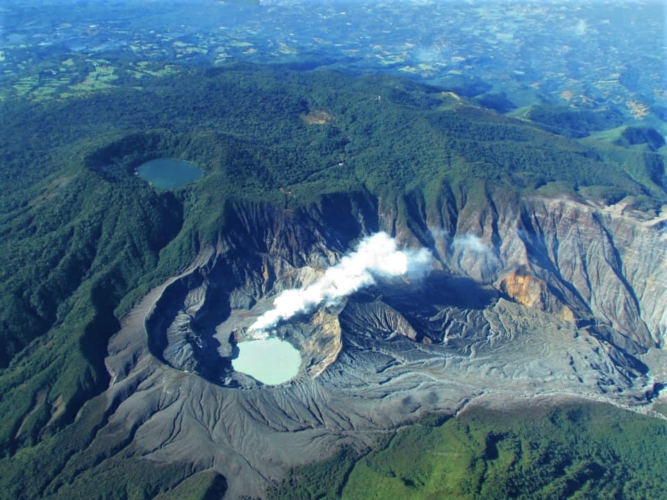
The slip/decompression generated a lake level rise of 1.4 m corresponding to a volume change of ~105 x 103 m3, this volume probably corresponding to the materials that were deposited in the lake. Since April 6, the level of the lake has tended to drop. The temperature of the hyper-acidic lake measured directly was 42°C and pH 0.33 on April 6. A sample of the hyper-acidic lake taken from the central part of the lake on March 18 shows relatively low concentrations of sulfate and chloride compared to the high concentrations observed during periods of strong degassing and phreatic eruptions. The current composition of the waters of Lake Poás is similar to that of the September 1995 period. The hot springs on the eastern wall of the crater (fumarolic fields that appeared in 2020) remain similar to last week. Abundant elemental sulfur is observed floating in the lake.
Rincon de la Vieja Volcano
Latitude: 10.83°N;
Longitude: 85.324°W;
Altitude: 1895m.
Current activity level: 3 (volcanic eruption)
Potentially associated dangers: Lahars, gas, phreatic and phreato-magmatic eruptions, proximal ballistic projections, acid rain, ashes.
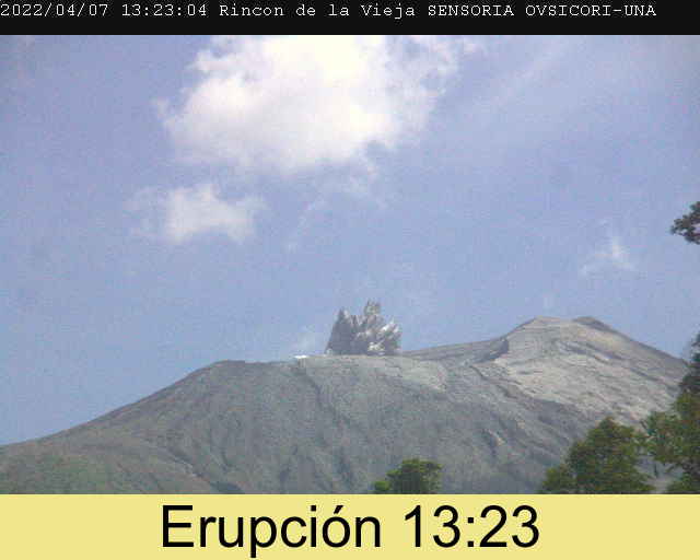
There have been 4 phreatic eruptions since early April, none of them energetic enough to generate lahars in the hours that followed. The seismic activity is stable: the recorded tremor is intermittent but stable in terms of frequency and amplitude, the LP type and « tornillos » type events have reappeared and have a stable frequency, few VT type events are recorded in the Las Pailas sector. Geodetic monitoring shows no significant deformation of the volcanic edifice.
Turrialba Volcano
Latitude: 10.025°N;
Longitude: 83.767°W;
Altitude: 3340m
Current activity level: 3 (volcanic eruption)
Potentially associated hazards: gas, ash emission, proximal ballistic projections, acid rain.

The last phreatic eruption occurred on February 28. Seismicity remains stable. An increase in the number and duration of short, low amplitude tremors is observed. VT type events are distal, associated with local faults. Geodetic monitoring shows a slight contraction of the volcanic edifice. Degassing remains stable, with a weekly average of CO2/SO2 of 22.8 +/- 3.3 and H2S/SO2 of 0.25 +/- 0.21, values similar to those of the previous week. The quantity of SO2 measured in the atmosphere by the satellite means reported last week remains variable but without any particular trend. The inspection of the bottom of the West Crater (or Murciélago Crater) with a drone shows some fumaroles in the bottom of the crater, mainly in the eastern sector, releasing water vapor and sulfur gases. The fumaroles record temperatures of at least 113 degrees Celsius when measured remotely with an infrared thermograph.
Source : Ovsicori.
Photos : Ovsicori , Raúl Mora/National Seismological Network) , Ovsicori , Rsn .
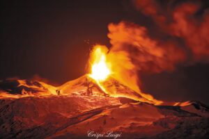
Alaska , Great Sitkin :
52°4’35 » N 176°6’39 » W,
Summit Elevation 5709 ft (1740 m)
Current Volcano Alert Level: WATCH
Current Aviation Color Code: ORANGE
Lava effusion continues at a slow rate. Seismic activity remains at a low level and clear midday satellite views showed elevated surface temperatures in the eruptive vent region and lava flow fronts, indicating continued effusion and flow field growth. Clear webcam views showed no significant emissions over the past day. It is possible that explosive activity could occur with little or no warning.
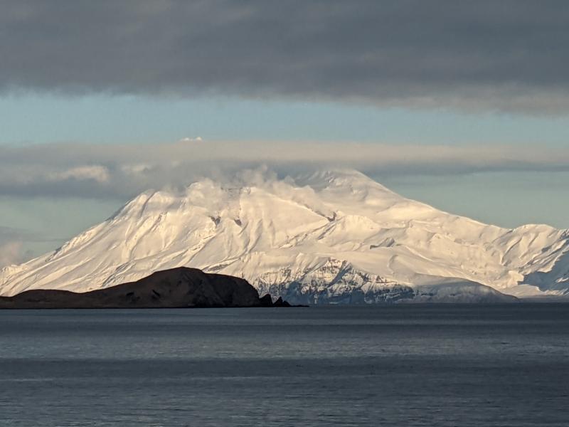
Steam and lava flows at Great Sitkin, photographed from Adak by Sarah Welter on January 14, 2022.
Great Sitkin is monitored by local seismic and infrasound sensors, satellite data, web cameras, and remote infrasound and lightning networks.
Source : AVO.
Photo : Welter, Sarah.
Vanuatu , Ambae :
Activity bulletin issued on 31st March 2022 at 12:29 pm:
The volcanic activity on Ambae Island is continuing in the major unrest level. The Volcanic Alert Level remains at Level 2.
The volcano activity consists of emission of steam and explosions of wet tephra ejected above the lake surface but confined within the caldera while only very light ash is deposited on villages located close to the volcano, especially those exposed to wind directions.
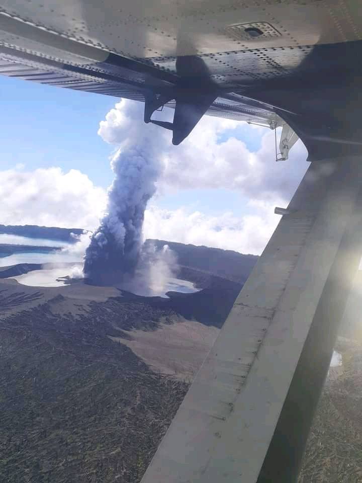
New observations confirmed that the volcanic cone has built up inside Lake Voui and Ambae volcano continues to emit volcanic gas and ash contained within Lake Vui, consistent with the activity of the Ambae volcano under Volcanic Alert Level 2 indicating ‘Major level of unrest; the Danger area remains at 2 km around the volcanic vents and within the area of flowing creeks. With this current volcanic activity, it is a useful reminder that eruptions can occur at any level of unrest with little or no warnings.
Source : Geohazard.
Photo : Johnston Aga
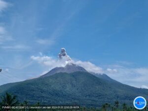
Indonesia , Semeru :
VOLCANO OBSERVATORY NOTICE FOR AVIATION – VONA
Issued : April 09 , 2022
Volcano : Semeru (263300)
Current Aviation Colour Code : ORANGE
Previous Aviation Colour Code : orange
Source : Semeru Volcano Observatory
Notice Number : 2022SMR98
Volcano Location : S 08 deg 06 min 29 sec E 112 deg 55 min 12 sec
Area : East java, Indonesia
Summit Elevation : 11763 FT (3676 M)
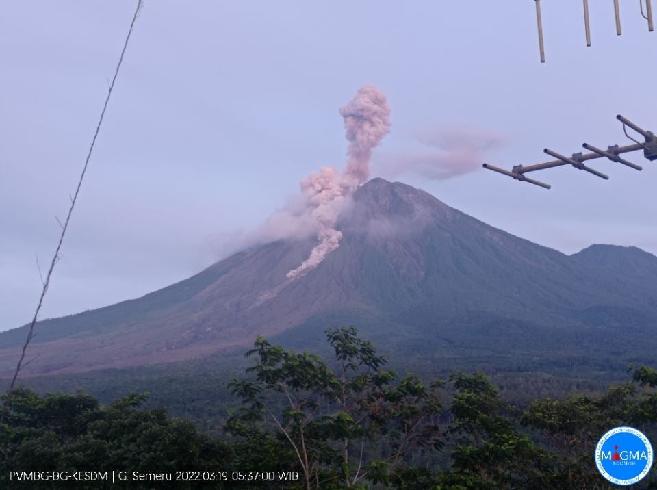
Volcanic Activity Summary :
Eruption with volcanic ash cloud at 22h53 UTC (05h53 local). Eruption and ash emission is continuing
Volcanic Cloud Height :
Best estimate of ash-cloud top is around 13043 FT (4076 M) above sea level, may be higher than what can be observed clearly. Source of height data: ground observer.
Other Volcanic Cloud Information :
Ash-cloud moving to northwest
Source : Magma Indonésie.
Photo : Magma Indonésie ( archive).
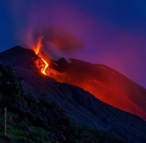
Ecuador , Wolf :
DAILY REPORT OF THE STATE OF WOLF VOLCANO. Saturday April 09, 2022.
Surface Activity Level: High, Surface Trend: Downward
Internal Activity Level: High, Internal Trend: Downward
Seismicity: From April 08, 2022, 11:00 a.m. to April 09, 2022, 11:00 a.m.:
No seismic event has been recorded at the volcano in the past 24 hours.
Other Monitoring Parameters:
The FIRMS system recorded 57 thermal alerts and the MIROVA system, 1 high (307 MW) and 1 moderate thermal alert in the last 24 hours.
Emissions / Ash columns:
There is no report from the Washington VAAC.
Observation:
Thanks to the images provided by the GOES-16 satellite, thermal anomalies can be observed due to the effect of advancing lava flows.
Alert level: Without alert.
Source et photo : IGEPN.