January 21 , 2024.
Indonesia , Lewotobi Laki Laki :
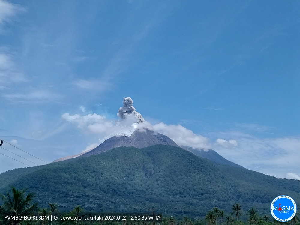
An eruption of Mount Lewotobi Laki Laki occurred on Sunday, January 21, 2024, at 12:49 WITA. The height of the eruptive column was observed to be ± 700 m above the peak (± 2,284 m above sea level). The ash column was observed to be white to gray in color with thick intensity, oriented towards the North and Northeast. The eruption was recorded on a seismograph with a maximum amplitude of 47.3 mm and a duration of 36 seconds.
SEISMICITY OBSERVATION
2 eruption earthquakes with an amplitude of 47.3 mm and a seismic duration of 53 to 93 seconds.
3 hot cloud avalanche earthquakes with an amplitude of 47.3 mm and a seismic duration of 47 to 116 seconds.
15 emission earthquakes with an amplitude of 10.3 to 47.3 mm and an earthquake duration of 64 to 217 seconds.
1 Continuous tremor with an amplitude of 3.7 to 7.4 mm, dominant value of 7.4 mm.
RECOMMENDATION
Communities around Mount Lewotobi Laki Laki and visitors/tourists do not carry out any activities within a radius of 5 km from the center of the eruption of Mount Lewotobi Laki Laki and in the 6 km sector to the North and North-East.
Source et photo : Magma Indonésie.
Colombia , Cumbal :
Weekly activity bulletin from the Cumbal Volcanic Complex
Regarding the monitoring of the activity of the CUMBAL VOLCANIC COMPLEX (CVC), the MINISTRY OF MINES AND ENERGY, through the COLOMBIAN GEOLOGICAL SERVICE (SGC), reports that:
Throughout the period between January 9 and 16, 2024, seismicity remained similar to that recorded the previous week, both in terms of occurrence and seismic energy. The predominance of seismicity linked to the fracture of the rock material continues. These earthquakes were located near the La Plazuela crater, towards the northeast of the CVC, at depths less than 3 km compared to the height of the La Plazuela crater (4,700 m above sea level) and ‘a maximum magnitude of 1.3.
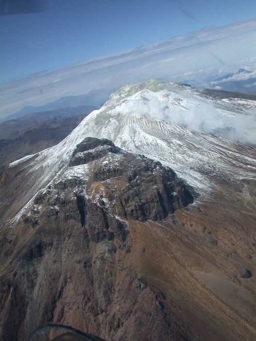
During the week, columns of gas emissions were observed mainly coming from the fumarole fields of El Verde, located in the Northeast sector of the CVC, and Los Rastrojos, Boca Vieja and Las Bandas, in the South-West part of the CVC. These emissions presented white columns, varying in height and dispersion depending on the predominant wind direction.
No significant variation was observed in the other geophysical and geochemical parameters of volcanic monitoring.
Volcanic activity remains on YELLOW ALERT Status: Active volcano with changes in base level behavior of monitored parameters and other manifestations.
Source : SGC
Photo : Ingeominas
Ecuador , Reventador :
DAILY REPORT ON THE STATE OF THE REVENTADOR VOLCANO, Saturday January 20, 2024.
Information Geophysical Institute – EPN.
Surface activity level: Moderate, Surface trend: No changes
Internal activity level: Moderate, Internal trend: No changes
Seismicity: From January 19, 2024, 11:00 a.m. to January 2, 2024, 11:00 a.m.:
The following table shows the number of seismic events from the reference station in the last 24 hours.
Explosion (EXP) 29
Long Period (LP) 11
Transmitting tremor (TREMI) 8
Tremor harmonic (TRARM) 4
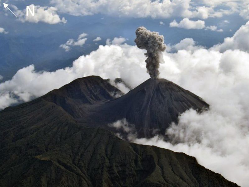
Precipitation/Lahars:
Rainfall is not recorded. **In the event of heavy rains, these could remobilize the accumulated materials, generating mud and debris flows which would descend the sides of the volcano and flow into adjacent rivers.
Emissions/ash column:
Due to weather conditions, no gas and ash emissions were recorded via the surveillance camera system or the GOES-16 satellite system. In contrast, the Washington VAAC has not released emissions reports in the past 24 hours.
Observation:
For 24 hours, the volcano has remained completely cloudy.
Alert level: Orange.
Source : IGEPN.
Photo : f-Naranjo ,
Hawaii , Kilauea :
Saturday, January 20, 2024, 9:11 AM HST (Saturday, January 20, 2024, 19:11 UTC)
19°25’16 » N 155°17’13 » W,
Summit Elevation 4091 ft (1247 m)
Current Volcano Alert Level: ADVISORY
Current Aviation Color Code: YELLOW
Activity Summary:
Kīlauea volcano is not erupting. Over the past day seismicity has been low and no unusual activity has been observed at the summit or the Southwest and East Rift Zones. Kīlauea summit remains pressurized; in recent months unrest has escalated quickly, and an eruption could occur in the future with little warning.
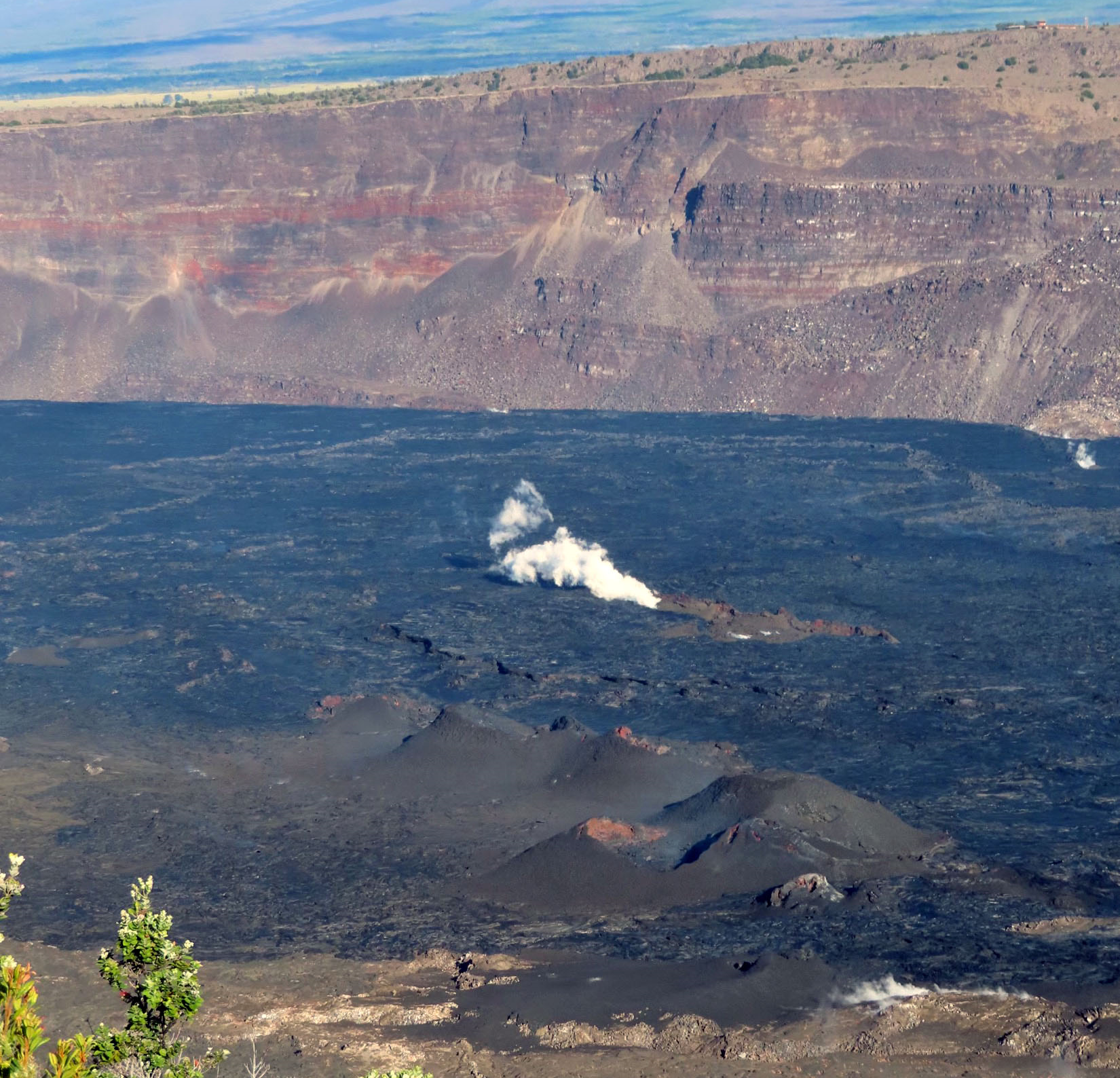
Summit Observations:
Over the past 24 hours, seismicity in Kīlauea’s summit region has been low, with approximately 20 small-magnitude earthquakes (less than M2) recorded beneath the caldera. However, periods of increased seismicity can be expected to continue during repressurization of the summit magma reservoir, which has been ongoing since the end of the September 2023 eruption.
Kīlauea’s summit region remains at a high level of inflation. Summit tiltmeters at Uēkahuna and Sand Hill have shown continued inflationary tilt over the past day.
Sulfur dioxide (SO2) gas emission rates remain low. Field measurements indicated an SO2 emission rate of approximately 70 tonnes per day on January 17, which was similar to measurements in October, November, and early December.
Source : HVO
Photo : USGS / J. Chang
Costa Rica , Poas / Rincon de la Vieja / Turrialba :
Daily report on the state of volcanoes. Date: January 20, 2024, Updated at: 10:54:00.
Poas Volcano
Latitude: 10.2
Longitude: -84,233
Altitude: 2,687 meters above sea level

Activity observed:
Over the past 24 hours, very frequent geyser or bubbling events have been observed in the lagoon. The background tremor remains almost continuous and variable in amplitude, with a frequency spectrum between 1 and 4 Hz. The CO2/SO2 and H2S/SO2 ratios are within the ranges of recent days. GNSS stations have recorded a trend towards contraction of the volcanic massif. This contraction intensified last week, particularly in the North-South direction.
Environmental conditions:
Winds are blowing from the South-West and the summit remains cloudy at the time of this report.
Activity Level: Warning (2)
Rincón de la Vieja Volcano
Latitude: 10.83
Longitude:-85.324
Altitude: 1,916 meters above sea level

Activity observed:
Over the past 24 hours, no significant eruptions have been recorded. The tremor continues to be recorded with frequencies between 1 and 5 Hz. On the other hand, sporadic low frequency signals are recorded. A new uplift is detected as well as a movement north of the summit.
Environmental conditions:
The wind blows from the South-West and the summit is cloudy.
Activity Level: Caution (3)
Turrialba Volcano
Latitude: 10,025
Longitude: -83,767
Altitude: 3,325 meters above sea level
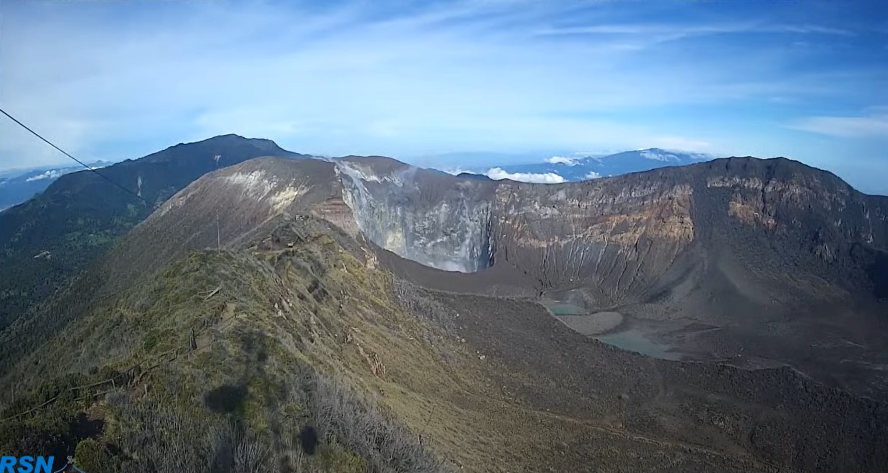
Activity observed:
Volcanic seismicity remains low with the occurrence of high and low frequency and low magnitude earthquakes. The gas ratios and the SO2 concentration at the head remain stable. No significant deformation is observed in the volcanic edifice.
Environmental conditions:
Geodetic observations do not show significant deformation of the volcano. Except at the summit of the volcano where we observe a more marked movement towards the crater than in recent months.
Activity Level: Warning (2)
Source : Ovsicori
Photos : Ovsicori , Federico Chavarría-Kopper / Ovsicori , RSN