October 1 , 2022.
Italy , Stromboli :
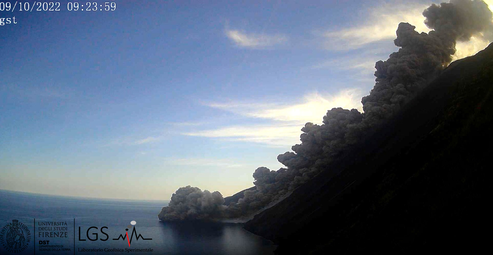
Press release on the activity of STROMBOLI, October 09, 2022, 09:25 (07:25 UTC).
The National Institute of Geophysics and Volcanology, Osservatorio Etneo reports that monitoring networks recorded a pyroclastic flow at 09:23 (07:23 UTC).
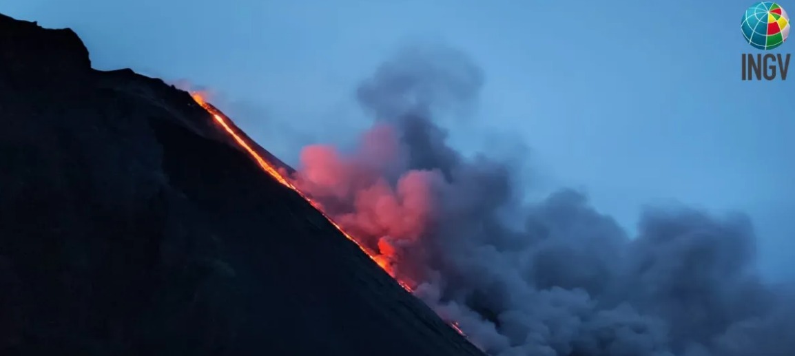
Stromboli on the evening of October 9, 2022, with the lava flow descending on the Sciara del Fuoco. Photo by Alessandro La Spina, INGV-Osservatorio Etneo
Press release on STROMBOLI activity, October 09, 2022, 10:24 (08:24 UTC).
The National Institute of Geophysics and Volcanology, Osservatorio Etneo, announces that the pyroclastic flow described in the previous press release was followed by other small pyroclastic flows that quickly reached the sea. well-fed lava that reaches the coast. Explosive activity showed no significant changes. From the seismic point of view, from 06:24 UTC an increase in the amplitude of the volcanic tremor was observed which reached high levels in correspondence with the pyroclastic flow; currently, the amplitude of the tremor is at medium-high levels. The signals from the inclinometer network of the TDF station show a very slight variation in intensity (0.05 microradians) between 7:15 and 7:30 UTC. There are no significant variations on the GNSS network.
Eruptive activity of October 9, 2022 and change of alert level.
Following the eruptive phenomena underway in Stromboli, the Department of Civil Protection ordered the change of the alert level from yellow to orange.
After a period of high eruptive activity, with a major explosion on September 29 and some short-lived lava overflows that occurred between September 27 and October 8, during the morning of October 9, 2022, Stromboli showed a strong increase volcanic activity culminating in abundant lava overflow. At 09:22 (07:22 UTC), the monitoring networks of the National Institute of Geophysics and Volcanology, Osservatorio Etneo, recorded the appearance of a pyroclastic flow from the North Crater area which was channeled on along the Sciara del Fuoco reaching the sea. The phenomenon was immediately followed by a considerable overflow of lava which propagated along the Sciara del Fuoco, branching into several lava flows which reached the coast.
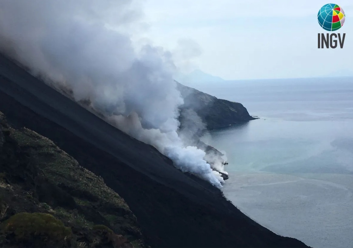
Entrance of the lava flow into the sea, Stromboli on the morning of October 9, 2022. The view is from the northern edge of the Sciara del Fuoco. Photo by Claudia D’Oriano, INGV-Pisa
At the present time (23:00 local time – 21:00 UTC – October 9) there is a well-fed lava flow reaching the coast and explosive activity in the northern area of the crater terrace.
Further updates will be communicated soon
Source : INGV.
Photos : INGV , LGS , Claudia D’Oriano, INGV-Pise , Alessandro La Spina, INGV-Osservatorio Etneo
La Réunion , Piton de la Fournaise :
Press release, Paris Institute of Earth Physics, Piton de la Fournaise Volcanological Observatory, October 10, 2022 – 08:45 (local time) – 04:45 (UTC time).
End of eruption
Following the resumption of the tremor on 6/10 around 11:40 a.m. local time, the tremor stopped on 7/10 around 3 p.m. local time.
Apart from a few lava projections observed in the cone on 10/6 between 6:30 p.m. and 7:30 p.m. local time, no evidence of activity has been observed since and no resumption of short-term activity is recorded.
Seismic activity below the summit remains weak.
Inflation (swelling) of the volcano is again recorded since 6/10 indicating a re-pressurization of the supply system under the volcano.
Alert Level: Backup
Source et photo : direction de l’OVPF-IPGP.
Alaska , Katmai :
58 16’44 » N 154 57’12 » W,
Summit Elevation 6716 ft (2047 m)
Current Volcano Alert Level: NORMAL
Current Aviation Color Code: GREEN
Strong northwesterly winds in the vicinity of Katmai and the Valley of Ten Thousand Smokes have picked up loose volcanic ash erupted during the 1912 Novarupta-Katmai eruption and carried it to the southeast across Shelikof Strait to Kodiak Island this morning. The National Weather Service has issued a SIGMET for this low-level event and suggests that the maximum cloud height is 5,000 ft above sea level.
This phenomenon is not the result of recent volcanic activity and occurs during times of high winds and dry snow-free conditions in the Katmai area and other young volcanic areas of Alaska. No eruption is in progress. All of the volcanoes of the Katmai area (Snowy, Griggs, Katmai, Novarupta, Trident, Mageik, Martin) remain at color code GREEN.
Resuspended volcanic ash should be considered hazardous and could be damaging to aircraft and health.
Source : AVO.
Photo : Cyrus Read.
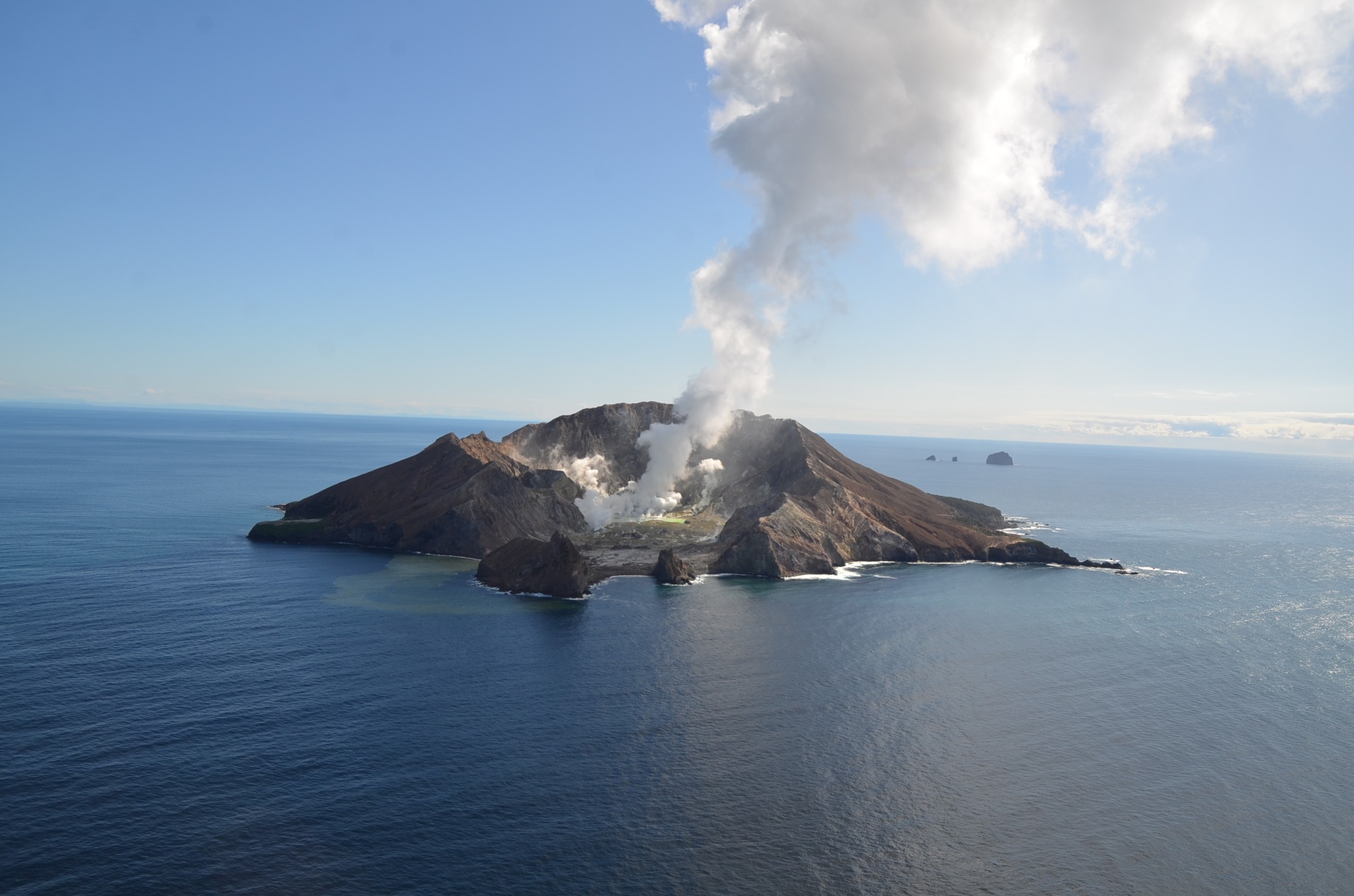
New Zealand , White Island :
Whakaari/White Island: Active vent creates minor ash emission. Volcanic Alert Level remains at Level 2.
Published: Mon Oct 10 2022 4:45 PM
Observation and gas flights have confirmed the active vent is continuing to emit a very vigorous steam and gas plume with a temperature of about 165 ºC. As the vent walls fail some minor ash emissions occur. Several periods of ash emission were noted during clear weather last week. The Volcanic Alert Level remains at 2.
Minor, passive ash emissions are again occurring intermittently from an active vent formed recently at Whakaari/White Island. On 5 October 2022, GNS Science volcanologists flying around the volcano observed the vent emitting a strong gas and steam plume near vertically. The temperature of the gas and steam plume was measured at 165 ºC. Our North Rim web camera has captured views of the steam and gas emission and minor ash emission. Sometimes the ash emissions have obscured the camera, but rain can clear the view.

View of the active vent area producing strong steam and gas emission. Wednesday October 5 when no ash was present.
The data from a gas observation flight last week measured a low discharge rate of sulphur dioxide (SO2) of 217 ± 19 tonnes/day. Observations from the TropOMI satellite, which images sulphur dioxide (SO2) once a day, has not shown any signals from Whakaari/White Island since Sunday 18 September.
The VAL remains at Level 2 (moderate to heightened unrest), acknowledging the current level of activity, but also continuing to acknowledge the greater level of uncertainty in our interpretation due to the current lack of consistent, useful real-time data. The Aviation Colour Code remains at Yellow, which reflects a reduced likelihood of minor ash emissions.
As the weather allows, we will be increasing the frequency of our gas and observation flights to the island until we can service our on-island equipment and power supplies. We still have intermittent access to webcams images from the island, providing some level of visual monitoring between our flights.
The Volcanic Alert Level reflects the current level of volcanic unrest or activity and is not a forecast of future activity. While Volcanic Alert Level 2 is mostly associated with volcanic unrest hazards (including discharge of steam and hot volcanic gases, earthquakes, landslides, and hydrothermal activity), potential for eruption hazards also exists and eruptions can still occur with little or no warning.
Source : Geonet / Agnès Mazot / Duty Volcanologist
Photos : Geonet .
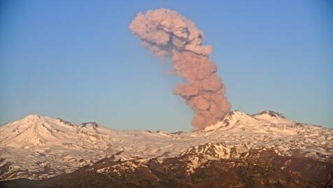
Chile , Nevados de Chillan :
Special Report on Volcanic Activity (REAV), De Nuble region, Nevados de Chillan volcanic complex, October 09, 2022, 7:30 p.m. local time (mainland Chile).
The National Service of Geology and Mines of Chile (Sernageomin) publishes the following PRELIMINARY information, obtained through the monitoring equipment of the National Volcanic Monitoring Network (RNVV), processed and analyzed at the Volcanological Observatory of the Southern Andes ( Ovdas):
Sunday, October 09, 2022, at 7:26 p.m. local time (22:26 UTC), the monitoring stations installed near the Nevados de Chillan volcanic complex recorded an earthquake associated with fluid dynamics (long period type), inside the volcanic system. .
The characteristics of earthquakes after their analysis are as follows:
ORIGINAL TIME: 7:26 p.m. local time (22:26 UTC)
REDUCED DISPLACEMENT: 599 cm2
ACOUSTIC SIGAL: 44 Pascals reduced to 1 km
The characteristics of surface activity are as follows:
MAXIMUM HEIGHT OF THE COLUMN: 2460 m above the point of emission
DISPERSION DIRECTION: North-North-East
The volcanic technical alert remains at the Yellow level.
Sources : Sernageomin.