September 18 , 2020.
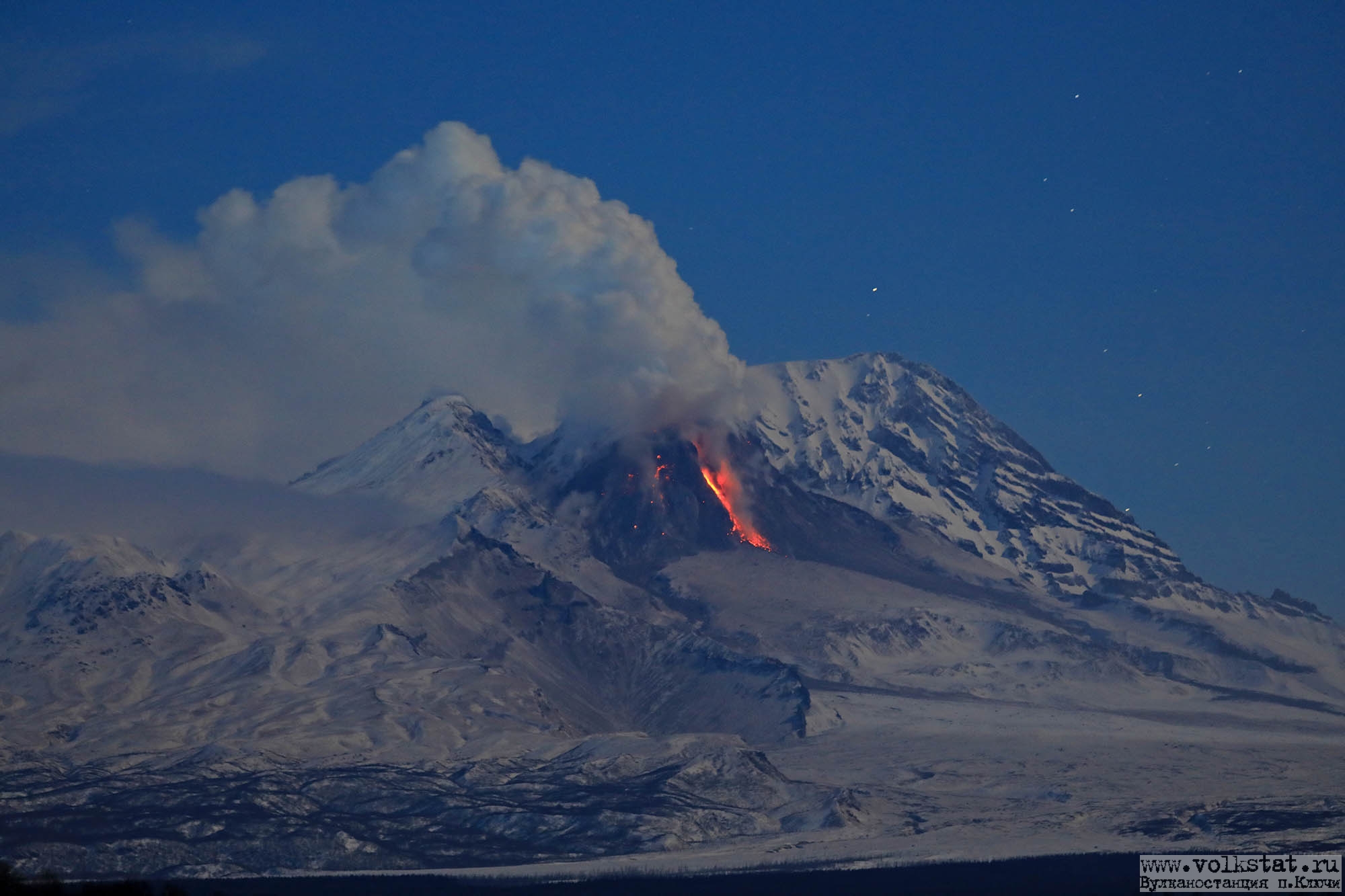
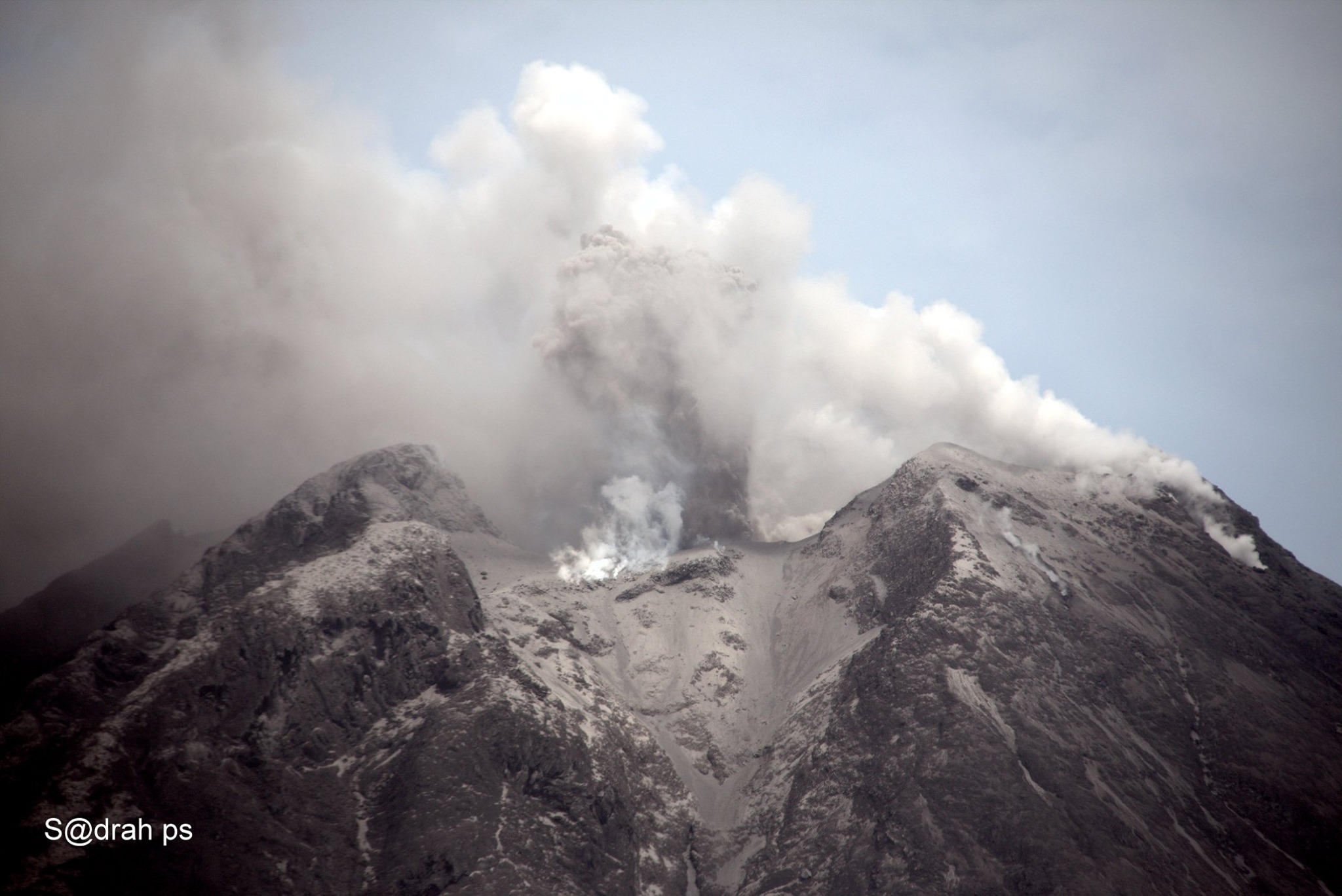
Kamchatka , Sheveluch :
56.64 N, 161.32 E;
Elevation 10768 ft (3283 m), the dome elevation ~8200 ft (2500 m)
Aviation Colour Code is ORANGE
The extrusive eruption of the volcano continues. Ash explosions up to 32,800-49,200 ft (10-15 km) a.s.l. could occur at any time. Ongoing activity could affect international and low-flying aircraft.
A growth of the lava dome continues, a strong fumarolic activity sometimes with some amount of ash, and an incandescence of the western part of the lava dome and hot avalanches accompanie this process. Satellite data showed a thermal anomaly over the lava dome on 11, 13-14 and 16-17 September, the volcano was obscured by clouds in the other days of week.
The high, isolated massif of Sheveluch volcano (also spelled Shiveluch) rises above the lowlands NNE of the Kliuchevskaya volcano group. The 1300 km3 volcano is one of Kamchatka’s largest and most active volcanic structures. The summit of roughly 65,000-year-old Stary Shiveluch is truncated by a broad 9-km-wide late-Pleistocene caldera breached to the south. Many lava domes dot its outer flanks. The Molodoy Shiveluch lava dome complex was constructed during the Holocene within the large horseshoe-shaped caldera; Holocene lava dome extrusion also took place on the flanks of Stary Shiveluch. At least 60 large eruptions have occurred during the Holocene, making it the most vigorous andesitic volcano of the Kuril-Kamchatka arc. Widespread tephra layers from these eruptions have provided valuable time markers for dating volcanic events in Kamchatka. Frequent collapses of dome complexes, most recently in 1964, have produced debris avalanches whose deposits cover much of the floor of the breached caldera.
Source : Kvert , GVP.
Photo : Volkstat ru / Y. Demyanchuk .
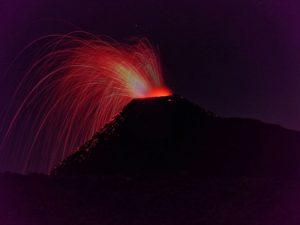
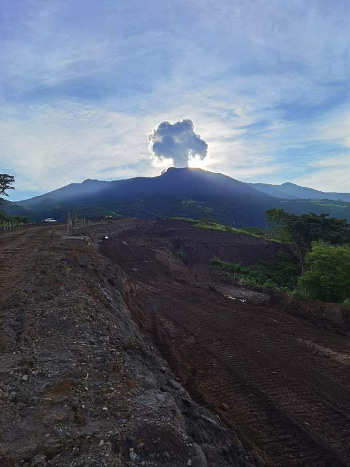
Indonesia , Sinabung :
The activity level has been at level III (SIAGA) since May 20, 2019 at 10:00 a.m. WIB. The Sinabung volcano (2460 m above sea level) has been erupting since 2013. The last eruption occurred on September 5, 2020, causing a column of gray eruption reaching 800 meters above the summit.
The volcano is clearly visible until it is covered in fog. It was observed that the main crater emits white smoke with moderate height, thick, about 200 meters above the summit. The weather is sunny to cloudy, the winds weak to strong, oriented to the east and south-east.
According to the seismographs of September 17, 2020, it was recorded:
1 emission earthquake
2 distant tectonic earthquakes.
Recommendation:
The public and visitors / tourists should not carry out activities in the villages that have been relocated, as well as within a radial radius of 3 km around the summit of G. Sinabung, and a sector radius of 5 km for the southern sector -East and 4 km for the East-North sector.
In the event of ash rain, people are advised to wear masks when leaving the house to reduce the health effects of volcanic ash. Secure drinking water facilities and clean the roofs of houses from dense volcanic ash so that it does not collapse.
People who live near the rivers flowing down from Mount Sinabung should be aware of the dangers of lahars.
VONA: The latest VONA message received the color code ORANGE, published on September 5, 2020 at 05:34:00. Volcanic ash was observed at an altitude of 3,260 m above sea level or about 800 m above the summit.
Source : PVMBG.
Photo :Sadrah Peranginangin.
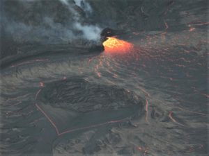
Hawaii , Mauna Loa :
19°28’30 » N 155°36’29 » W,
Summit Elevation 13681 ft (4170 m)
Current Volcano Alert Level: ADVISORY
Current Aviation Color Code: YELLOW
Activity Summary:
Mauna Loa Volcano is not erupting. Rates of deformation and seismicity have not changed significantly over the past week and remain above long-term background levels.
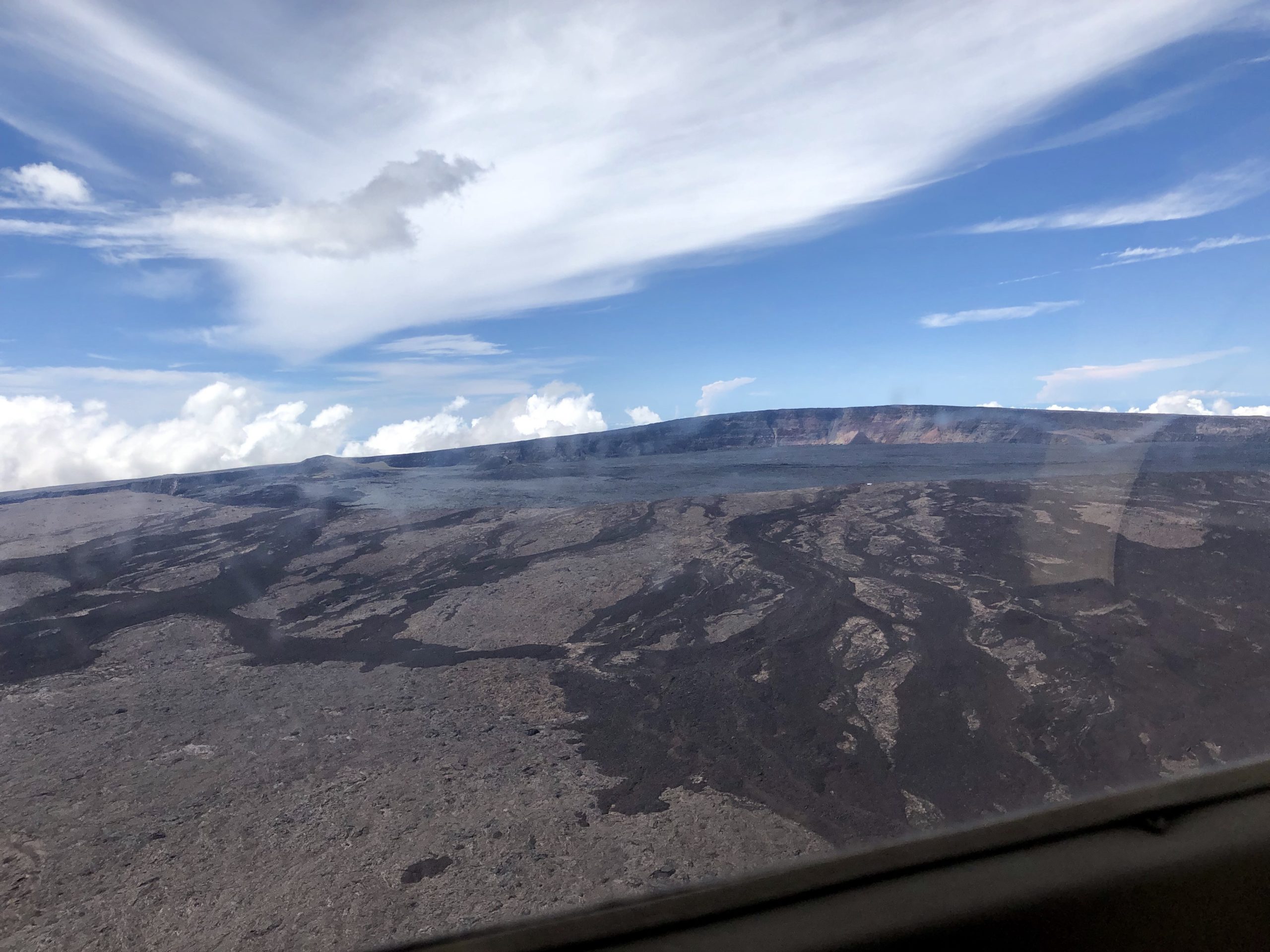
Civil Air Patrol captured this aerial image of Mauna Loa’s summit caldera, Moku‘āweoweo, on Sunday, October 20, 2019. The true summit of Mauna Loa is located just to the right of the center of the image, at the highest location above the caldera wall in the background. The cones that formed during the 1940 (right) and 1949 (left) eruptions are visible in the distant left side of the image. Lava flows in the foreground of the image, which flowed in a direction south of the summit of Mauna Loa, were active prior to formation of the summit caldera approximately 1,000 years ago.
Observations:
Over the past week, HVO seismometers recorded approximately 67 small-magnitude earthquakes – all below M2.5 – beneath the volcano’s summit and upper-elevation flanks. The majority of these earthquakes occurred at shallow depths of less than 8 kilometers (approximately 5 miles) below ground level.
Global Positioning System (GPS) measurements continue to indicate slow, long-term summit inflation, consistent with magma supply to the volcano’s shallow storage system.
Gas concentrations and fumarole temperatures at both the summit and Sulphur Cone on the Southwest Rift Zone remain stable.
Webcam views have revealed no changes to the landscape over the past week.
Source et photo : HVO.
Costa Rica , Turrialba / Poas / Rincon de la Vieja / Irazu :
Turrialba volcano:
Lat: 10.025 ° N; Long: 83.767 ° W;
Altitude: 3340 m.s.n.m.
Current activity level: 2 (active volcano)
Potentially associated hazards: gas, ash emission, proximal ballistic projections.
No ash emission was observed. The seismic activity is stable, with a stable number of LP type events. Few TT type events are recorded. The contraction and subsidence of the Turrialba-Irazú massif continues. The CO2 / SO2 and H2S / SO2 ratios are stable. The SO2 flow remains low (~ 100 t / day) with a slight downward trend. No thermal anomaly was detected by the MODIS analysis.
Poas volcano:
Lat: 10.2 ° N; Long: 84.233 ° W;
Altitude: 2780 m.s.n.m.
Current activity level: 2 (active volcano)
Potentially associated hazards: gas, phreatic eruptions, proximal ballistic projections.

No éruption was detected. There was a slight increase in the number of LP-type events and a prolonged tremor on September 13. There is no significant deformation observed by geodetic measurements. The SO2 / CO2 and H2S / SO2 ratios remain variable within the normal range of values. The SO2 flow rate remains low with values below 50 t / day. The level of the lake dropped slightly during the week and the estimated evaporation increased again.
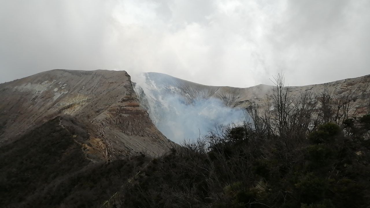
Rincon de la Vieja volcano:
Lat: 10.83 ° N; Long: 85.324 ° W;
Altitude: 1895 m.s.n.m.
Current activity level: 3 (erupting volcano)
Potentially associated hazards: gas, phreatic eruptions, proximal ballistic projections, lahars.
Several low energy phreatic eruptions have been recorded. The number of LP-type events peaked on September 13, the amplitude of the tremor signal increased slightly. A swarm of VT-type events was recorded on September 11. Significant contraction and deflation of the base and top of the volcanic edifice begin to be observed. No thermal anomaly was detected by the MODIS analysis.
At 06:32:00 local time on September 17, 2020, an eruption was recorded on the Rincon de la Vieja volcano, with a column that rose 700 meters above the crater and 2616 m.s.n.m. (meters above sea level, 8,580.48 feet).
Duration of activity: 1 minute.
Seismic activity is similar compared to yesterday.
At the time of this report, the winds are blowing northwesterly.
The 6:32 a.m. eruption did not generate a lahar. A banded and discontinuous tremor is observed between 1 and 4 Hz.
Irazu volcano
Lat: 9.979 ° N; Long: 83.852 ° W;
Altitude: 3432 m.s.n.m.
Current activity level: 1 (active)
Potentially associated hazards: landslides.
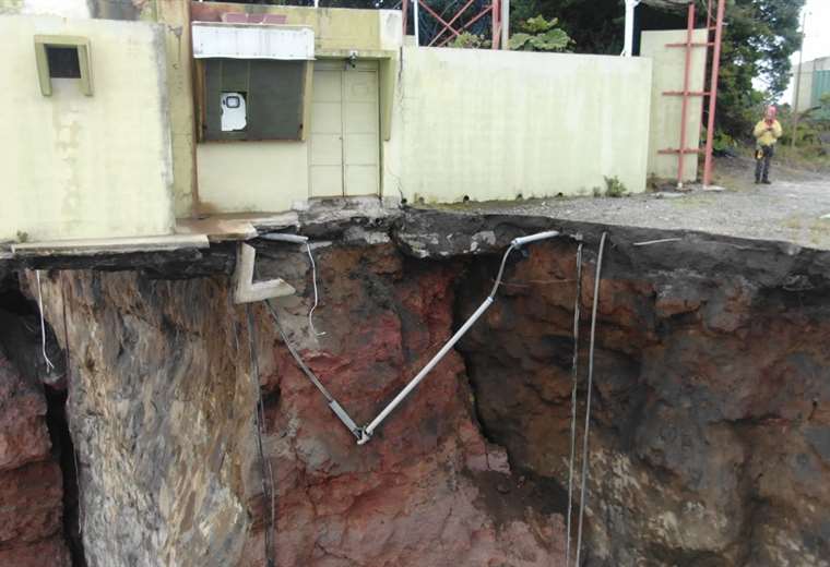
The OVSICORI seismic network recorded 3 landslides during the week (the last on September 11) and one LP type event on September 14. The GPS measurements of the terrain show a rapid movement towards the cliff in the northwestern part of the communication tower area (~ 1m / year) with a slight acceleration. Comparison between satellite photos (Sentinel-2) shows an affected area of vegetation up to 5.2 km away from the August 26 collapse (info: USGS-VDAP).
Source : Ovsicori .
Photos : Jean Paul Calvo / RSN , Jairo García , Wagner Salazar , Teletica .