September 02 , 2020.
Italy / Sicily , Etna :
Weekly bulletin, 08/24/2020 – 08/30/2020. (date of issue 01/09/2020)
SUMMARY OF THE STATE OF ACTIVITY
In the light of surveillance data, it is highlighted:
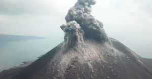
1) VOLCANOLOGICAL OBSERVATIONS: Explosive activity at the New Southeast Crater, the Northeast Crater and the Voragine Crater with formation of eruptive clouds. Degassing activity at the Bocca Nuova crater.
2) SEISMOLOGY: low seismic activity of fracturing; amplitude of the volcanic tremor mainly at the average level.
3) INFRASON: Increase in infrasound activity.
4) DEFORMATIONS: The Etna soil deformation monitoring networks did not show any significant variations during the last week.
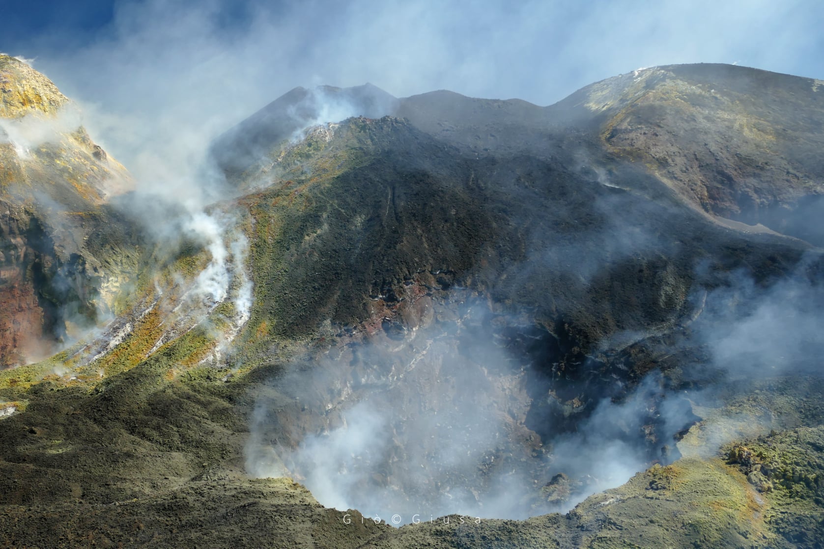
Bocca Nuova Etna 3270m. 25 August 2020
5) GEOCHEMISTRY: The flow of SO2 is at a medium-low level.
The flow of CO2 emitted by the soil remains at a low level.
The partial pressure of dissolved CO2 in groundwater is at average values.
There are no new measures relating to the C / S ratio (last measure dated 17/07/2020).
There is no update of the helium isotope ratio measurements (last measurement dated 07/27/2020)
6) SATELLITE OBSERVATIONS: The thermal activity in the summit area is at a medium-low level.
VOLCANOLOGICAL OBSERVATIONS
The monitoring of the volcanic activity of Etna, during the week in question, was carried out by analyzing the images of the surveillance cameras of the INGV, Etneo Observatory (INGV-OE), and through observations carried out by INGV staff. OE in the summit area.
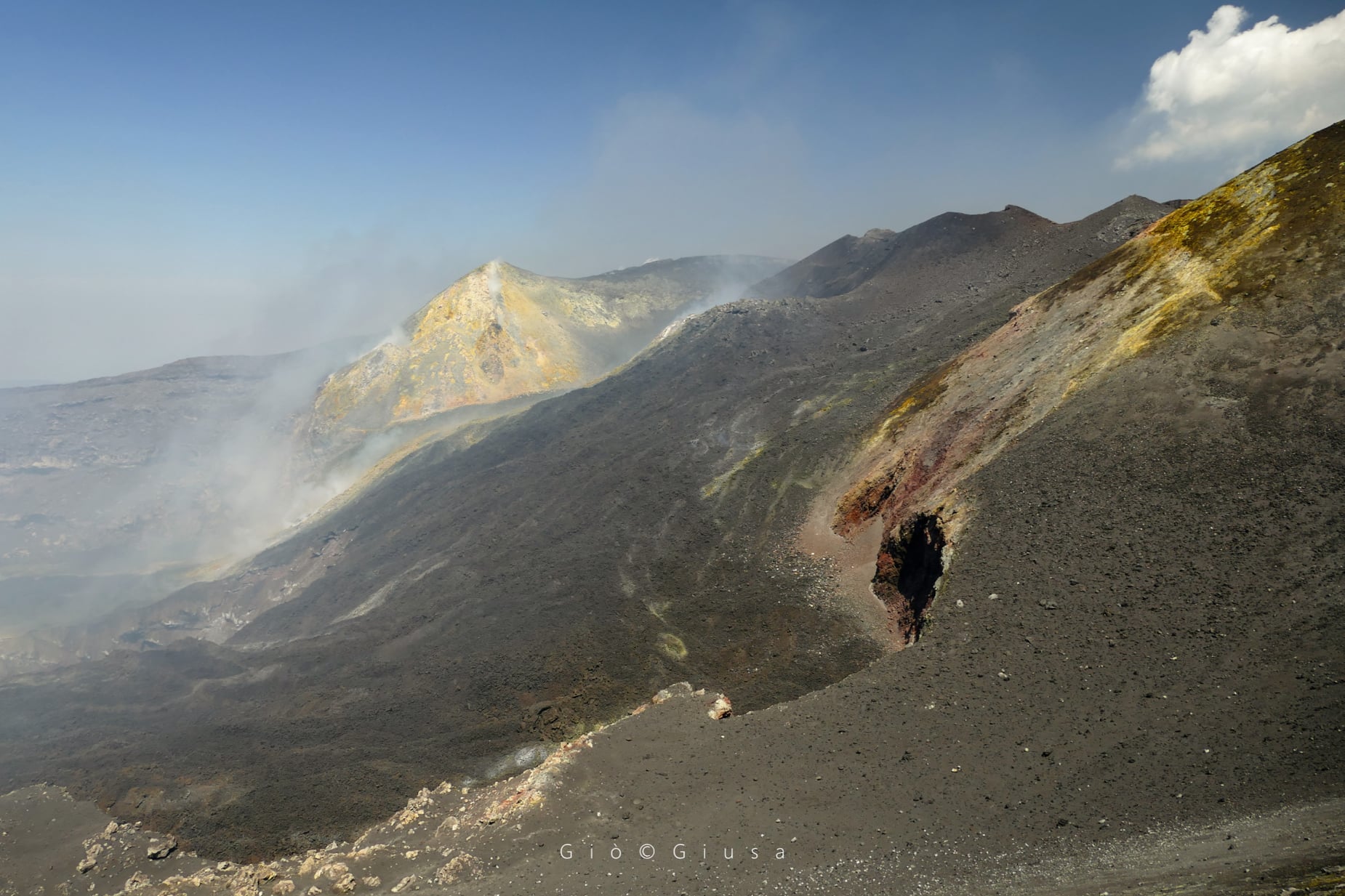
Bocca della Sella from the New South East Crater. Etna South August 29, 2020
Overall, the state of activity of the summit craters did not show any significant changes compared to that observed the previous week (see Rep. N ° 35/2020), and is characterized mainly by intracratical activity. strombolian and discontinuous ash emissions at the New Crater. south-east (NSEC), intra-crater strombolian activity at the Northeast crater (NE), sporadic and light ash emissions at Voragine crater (VOR) and degassing activity at Bocca Nuova crater (BN ).
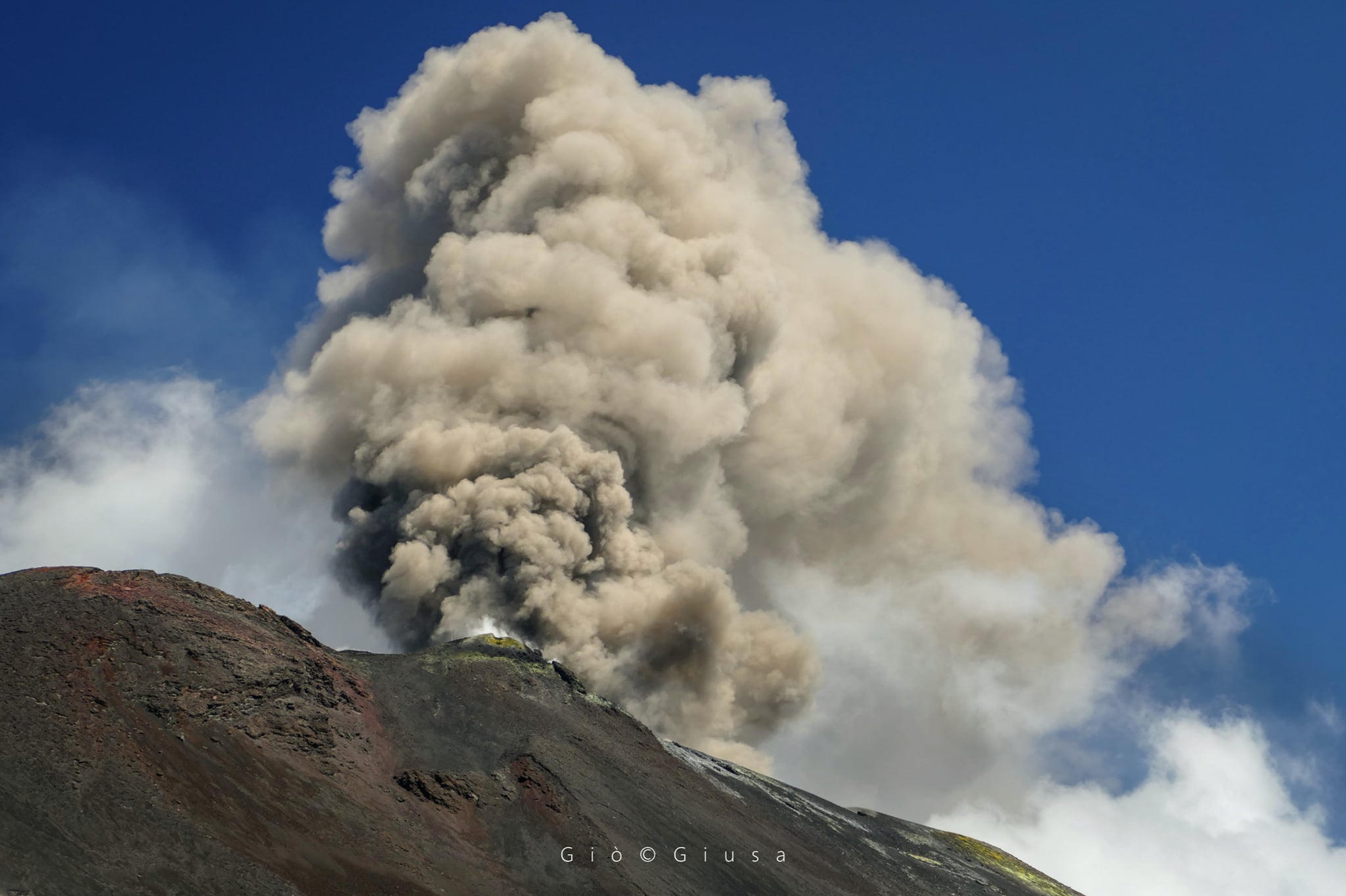
In particular, the New Southeast Crater was characterized by an intracrater explosive activity significantly variable in frequency and intensity which during the most energetic phases produced the launch of coarse pyroclastic material on the crater rim. This activity produced the progressive widening of the mouth of the « saddle cone ». The activity was also characterized by discontinuous volcanic ash emissions with the formation of generally dilute eruptive clouds that rapidly dispersed into the atmosphere. Between the afternoon of August 25 and the wee hours of August 26, the ash emission increased in intensity, producing a volcanic cloud 4.5 km above sea level which dispersed towards the south-south-east and caused a modest fall of ash in the inhabited centers of this sector of the volcano as far as Catania. A further increase in explosive activity also occurred on the morning of August 29. The volcanic cloud generated during this activity was about 4.5 km high, dispersed towards the East-North-East and did not cause ash fallout in the inhabited centers.
The area of the central craters (Voragine – Bocca Nuova). Etna August 31, 2020
Finally, ground observations made by INGV-OE personnel in the summit area showed that the intracrater Strombolian activity of the Northeast Crater (NEC) is produced by at least two explosive vents with launches of products that remain confined under the rim of the crater. The Voragine Crater has been characterized by outgassing activity with occasional explosions from the main cinder cone which produce the launch of coarse materials and modest ash emissions which are rapidly dispersed into the atmosphere. Rather, the Bocca Nuova (BN) crater has been characterized by degassing activities from the pit crater, which continues to be affected by slow and gradual enlargement, and by the fumarole systems present along the internal walls.
Source : INGV.
Photos : Gio Giusa
La Réunion , Piton de la Fournaise :
Seismicity:
In August 2020, the OVPF recorded in the Piton de la Fournaise massif in total:
• 20 superficial volcano-tectonic earthquakes (0 to 2.5 km deep) under the summit craters;
• 1 deep earthquake (2.5 to 5 km deep);
• 192 collapses (in the Dolomieu Crater and at the ramparts of the Enclos Fouqué and the Rivière de l’Est (36)).
The seismicity under the Piton de la Fournaise during the month of August 2020 remained low with on average less than one superficial volcano-tectonic earthquake per day.

Deformation:
Following the cessation of inflation (swelling) of the building around July 13, no significant deformation was observed at the terminal cone in August 2020 except for a very slight deflation at the level of the summit area.
On the other hand, the acceleration of movements observed on the upper part of the eastern flank since the eruption of October 2019 continues.
Ten months after the start of this acceleration, the subsidence and the eastward movement recorded at the GPSG station, located at an altitude of 1005 m on the eastern flank, reached 18 and 14 cm respectively.
Interferometric satellite data show that this movement extends over an area of about 6-8 km² in the upper part of the major slopes. If part of the subsidence (subsidence) can be attributed to the compaction / contraction of the lava flows set up in this sector during the eruptions of 2019-2020, this phenomenon cannot explain the movements recorded more than 500 m from the lava fields. These deformations can have several origins including persistent fluid movements at depth towards this flank which was intruded on numerous times in 2019 – 2020; the closure / contraction of the dykes / sills that fueled the 2019-2020 eruptions; or a destabilization of this flank.
A helicopter reconnaissance carried out with the assistance of SAG and PGHM on August 12, 2020 did not show any new fracturing zone visible on the surface on the eastern flank of the volcano.
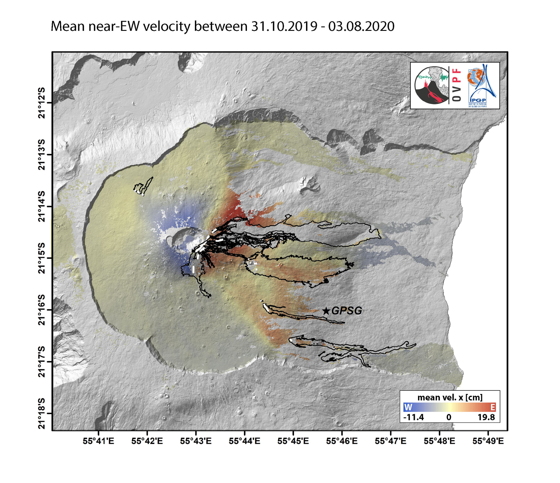
Maps of the average speeds of vertical (left) and east-west (right) trips deduced from InSAR data between October 31, 2019 and August 3, 2020. The intensity of the trips is given by the colored bar. The white lines and black contours respectively represent the eruptive cracks of 2019-2020 and their associated lava flows. The star shows the location of the GPSG station (© OVPF-IPGP).
Balance sheet:
Since the July 3 intrusion, seismic activity has remained low and inflation came to a halt around July 13. It should be noted that since 2016, the recharge of the superficial magmatic reservoir under the Piton de la Fournaise has been carried out by pulses, so such phases of lull in deformations and seismicity have already been observed on several occasions between 2016 and 2020 over periods ranging from about 15 to 80 days, and eruptions can be triggered after only a short period of restarting the shallow reservoir recharge.
Source and photos : OVPF .
Read the article : http://www.ipgp.fr/sites/default/files/ovpf_20200901_bullmensufinal.pdf
Italy , Stromboli :
Weekly bulletin, 08/24/2020 – 08/30/2020. (date of issue 01/09/2020)
SUMMARY OF THE STATE OF ACTIVITY
In the light of surveillance data, it is highlighted:
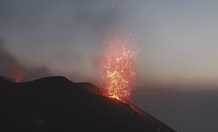
1) VOLCANOLOGICAL OBSERVATIONS: During this period, a normal explosive activity of strombolian type was observed. The total hourly frequency of the explosions fluctuated between the mean-low values (8 events / h day August 26) and the average-high values (17 events / h day August 24).
The intensity of the explosions ranged from low to high in the North crater area and was medium to high in the Center-South crater area.
2) SEISMOLOGY: The seismological parameters do not show significant variations.
4) DEFORMATIONS: The island’s soil deformation monitoring networks did not show any significant changes during the period under review.
5) GEOCHEMISTRY: The flow of SO2 occurs at an average level
There are no updates on the soil CO2 flux data.
There is no update for the CO2 / SO2 report (last measurement on 07/19/2020).
The isotopic values of Helium (last update on 08/24/2020) are at medium-low values.
6) SATELLITE OBSERVATIONS: The thermal activity in the summit area is at a medium-low level.
VOLCANOLOGICAL OBSERVATIONS
In the observation period, the eruptive activity of Stromboli was characterized by the analysis of the images recorded by the surveillance cameras INGV-OE located at an altitude of 190 m, Punta dei Corvi and 400 m. The Pizzo camera was damaged during the event of July 19, 2020 and is being restored in the INGV-OE laboratories.
Referring to the observations made by INGV-OE staff during the inspection on August 22, the morpho-structural arrangement of the crater terrace consists of three eruptive vents located in the area of the North crater and at least three eruptive vents located in the Center – South crater area. All the vents are placed inside the depression which occupies the terrace of the crater.
In the area of the North crater, the N1 crater, with three emission points, produced low to high intensity explosions (the products of some explosions exceeded 200 m in height) emitting coarse materials (lapilli and bombs) which are fallout abundantly with radial distribution. Vent N2 showed low intensity explosive activity (less than 80 m in height) emitting coarse materials. The average frequency of the explosions varied from 3 to 10 events / h.
In the Center-South zone, the explosions emitted mainly fine materials mixed with coarse materials with a medium-high intensity (the products emitted often exceeded 250 m in height).
The frequency of the explosions varied from 2 to 8 events / h.
The amplitude of the volcanic tremor generally had values between low and medium-low.
Source : INGV.
Photos : Web cam , LGS – Laboratorio Geofisica Sperimentale.
United States , Yellowstone :
44°25’48 » N 110°40’12 » W,
Summit Elevation 9203 ft (2805 m)
Current Volcano Alert Level: NORMAL
Current Aviation Color Code: GREEN
Recent work and news
August field work in Yellowstone National Park included the deployment of hundreds of nodal seismometers. These temporary stations, each the size of a coffee can and deployed throughout the park, are designed to record seismic waves that are generated by a special vibroseis truck and that will bounce off the top of the mostly-solid magma chamber beneath Yellowstone Caldera. The seismic experiment, which will run in September, will provide the highest-resolution views of the subsurface ever collected at Yellowstone!
https://www.facebook.com/YellowstoneNPS/videos/2653881088193039/
August was a spectacular month for geysers in Yellowstone. Steamboat Geyser erupted five times during the month, on August 3, 9, 14, 20, and 26, bringing the total number of eruptions for the year to 34. In addition, on August 26 Giantess Geyser, in the Upper Geyser Basin not far from Old Faithful, erupted for the first time in over six and a half years! Geyser activity like this is common and is not a reflection of deeper volcanic processes, but it is a spectacular sight to behold.
Seismicity
During August 2020, the University of Utah Seismograph Stations, responsible for the operation and analysis of the Yellowstone Seismic Network, located 82 earthquakes in the Yellowstone National Park region. The largest event was a minor earthquake of magnitude 2.6 located 7 miles west of Old Faithful, Yellowstone National Park, on August 20 at 11:12 PM MDT.
A small swarm of 12 earthquakes occurred about 12 miles north-northeast of Old Faithful on August 18. The largest swarm event was a micro earthquake of magnitude 0.9 on August 18 at 4:07 AM (MDT).
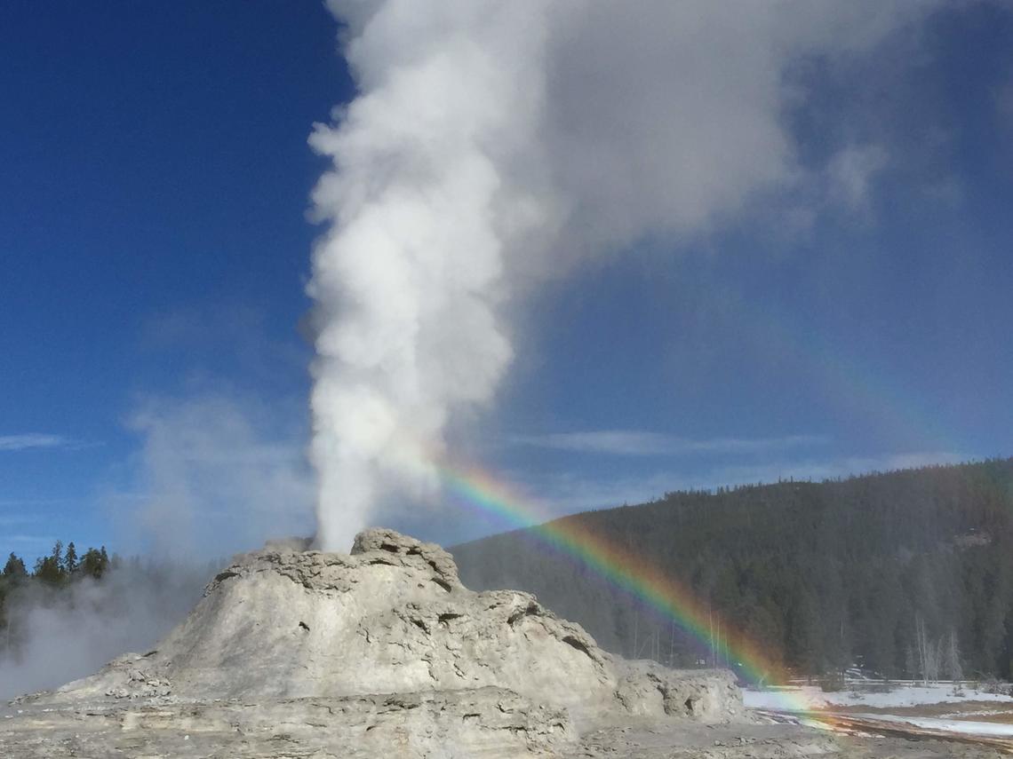
View of Castle Geyser, near Old Faithful, in eruption, taken from the boardwalk, November 5, 2019.
Earthquake sequences like these are common and account for roughly 50% of the total seismicity in the Yellowstone region.
Yellowstone earthquake activity remains at background levels.
Ground deformation
Deformation rates and styles at Yellowstone, as recorded by continuous GPS stations, have not changed significantly in many months. Subsidence of Yellowstone Caldera, which has been ongoing since 2015, continued at an average rate of 2-3 cm (about 1 in) per year. In the area of Norris Geyser Basin, little deformation has been detected by a nearby GPS station since the start of 2020.
Source : YVO.
Video : Yellowstone National Park.
Photo : Shaul Hurwitz USGS.
Ecuador , Sangay :
The Geophysical Institute of the National Polytechnic School reports that:
Today, the SAGA seismic station has been recording from about 3:30 p.m. (TL) until now a high frequency signal, associated with the appearance of mudslides and debris (lahars) that descend through the ravines of the volcano. This phenomenon has been recurring since May 2019 and finds its origin because the intense rains in the volcano, remobilize the material accumulated throughout these months of activity. Proximity to rivers is not recommended.
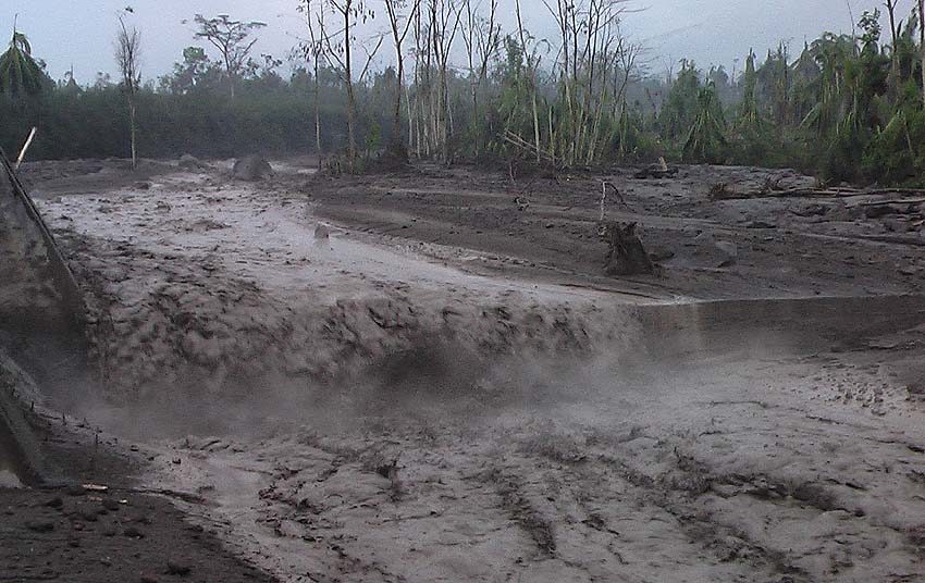
The Geophysical Institute of the National Polytechnic School is keeping an eye on the activity of the volcano and will report on any changes that may be recorded.
Source : GEOPHYSICAL INSTITUTE / NATIONAL POLYTECHNIQUE SCHOOL
Photo : Caroline Sarrazin