June 05 , 2019.
The site is finally back, but your servant will take a few days off. Return on June 14th.
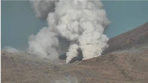
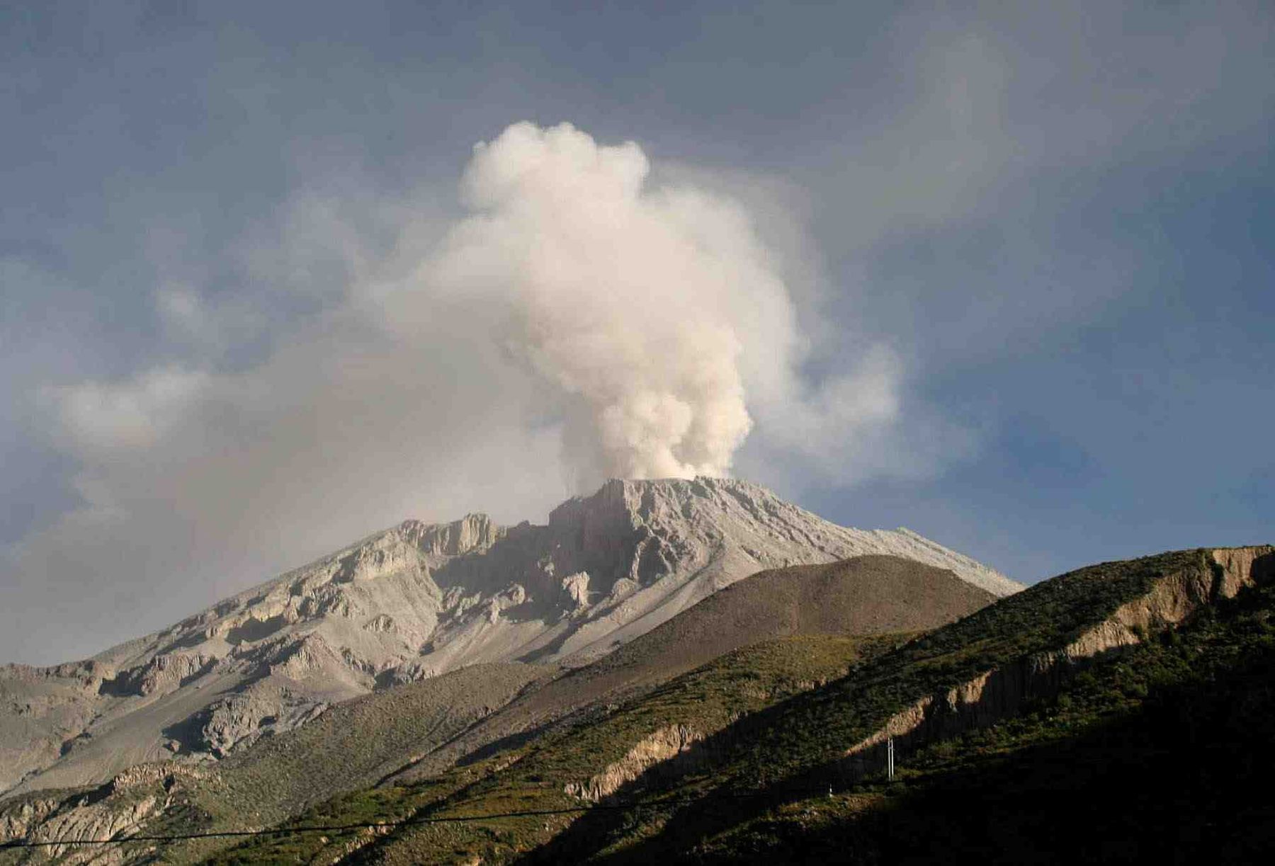
Italy / Sicily , Etna :
COMMUNICATION on the VOLCANIC ACTIVITY of June 04, 2019 at 14:16:41 (UTC) – ETNA.
The National Institute of Geophysics and Volcanology, Osservatorio Etneo, announced that the analysis of the surveillance network camera images and the observations made by the staff of the INGV last night on June 3 and during the morning of Today 4 June, have observed that the activity continues from the segment of the eruptive fissure at 2850 m . The intensity of the explosive activity has, however, greatly diminished: at the end of the morning, the activity of crack projection was observed with the launching of lava flaps whose height reached ten meters. The lava fronts, which in recent days had reached an altitude of 1,700 m, are cooling. The active fronts are located at an altitude of between approximately 2500 and 2300 m approximately.
With regard to volcanic tremor, the slightly downward trend that characterized its average amplitude from the morning of May 30 continued until the early hours of the day. Around 06:00 UTC (08:00, local time) today, the magnitude of the tremors shows a modest tendency to increase and, at the end of the morning, they reached an average level; this trend was also observed in the afternoon.
Source : Boris Behncke / INGV
Photo : Gio Giusa.
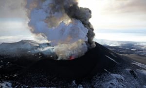
Peru , Sabancaya :
Period of analysis: May 27 to June 2, 2019 Arequipa, June 3, 2019
Alert level: ORANGE
The Geophysical Institute of Peru (IGP) reports that the eruptive activity of the Sabancaya volcano remains moderate. Therefore, for the following days, no significant change is expected.
Analysis of records obtained from the Sabancaya volcano seismic network for the period 27 May to 2 June 2019 identified the occurrence of about 949 évents, associated with the movement of magmatic fluids. During this week, an average of 17 daily blasts of average to low intensity were recorded.
The monitoring of the deformation of the volcanic structure using GNSS data (processed with fast orbits) does not show significant anomalies. Visual surveillance, using surveillance cameras, identified the appearance of eruptive columns up to 3.5 km high at the summit of the volcano, whose ashes were dispersed to the East, South-East and Northeast of Sabancaya. Satellite monitoring revealed 12 thermal anomalies on the volcano between 6 and 35 MW, associated with the presence of a hot body near the surface and the persistence of explosions.
RECOMMENDATIONS:
Do not approach a radius less than 12 km from the crater.
In case of ash fall, cover your nose and mouth with damp cloths or masks.
Keep the doors and windows of the houses closed.
Stay informed at all times about Sabancaya’s volcanic activity thanks to the reports published by the IGP.
Source : IGP.
Photo : Auteur inconnu.
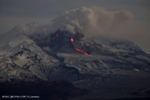
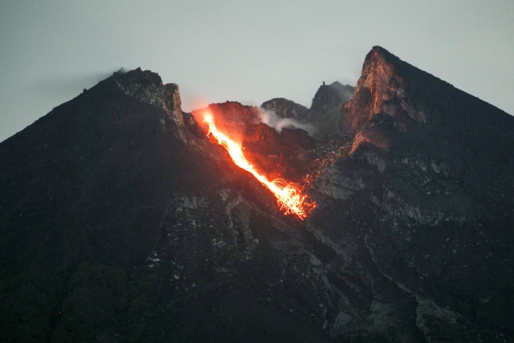
Indonesia , Merapi :
PRESS RELEASE ON THE ACTIVITY OF G. MERAPI ON 1 JUNE 2019.
1. Mount Merapi entered a magmatic eruption phase on August 11, 2018, marked by the emergence of lava domes that continue to grow at a low rate of about 3,000 m3 / day, which lasted up to in January 2019. After that, the lava dome stopped growing and, since January 29th, the activity is entering the phase of formation of hot clouds and lava avalanches.
2. As of 1 June 2019, there were 72 occurrences of hot cloud with an average slip distance of 1 km and a maximum of 2 km towards K. Gendol. Based on heat cloud modeling resulting from the potential collapse of the current 458,000 m3 lava dome volume, the greatest cloud slip distance is expected to be no more than 3 km from the summit of the mount Merapi towards the K. Gendol.
3. Seismicity is currently dominated by seismic avalanches (RF) 30 times / day, followed by multiphase (MP) earthquakes 4 times / day, low frequency (LF) events 3 times / day, and tremor. Issuing land (DG) 3 times / day. Shallow volcano-tectonic earthquakes (VTB) and deep volcano-tectonic earthquakes (VTA) occur occasionally.
4. The appearance of MP and VT type seismicity indicates that the supply of magma is still in progress, even at a low rate.
5. Depending on the conditions of the above volcanic activity, activity status is always defined at WASPADA alert level with recommendations:
at. Outside the 3 km radius around the summit, the community can move as usual.
b. Tourist areas around Mount Merapi such as Kaliurang, Kaliadem, Klangon, Deles and other areas beyond the 3 km radius of the summit can be visited safely.
c. The community and the regional government are invited to prepare procedures to manage emergency conditions for community / tourist activities in Kali Gendol and surrounding areas.
d. People around are invited to anticipate the disturbances caused by volcanic ash.
Source : Directeur du BPPTKG Hanik Humaida .
Photo : Antara/Hendra Nurdiyansyah.
United – States , Yellowstone :
44°25’48 » N 110°40’12 » W,
Summit Elevation 9203 ft (2805 m)
Current Volcano Alert Level: NORMAL
Current Aviation Color Code: GREEN
Recent work and news
In May 2019, Steamboat geyser returned to its pattern of more frequent activity, with water eruptions occurring almost weekly, on May 3, 8, 13, 20, and 27. Field work by YVO scientists during the month involved the deployment of semipermanent GPS stations to 15 locations around Yellowstone National Park, as well as maintenance of the Norris temperature network—including the datalogger at Steamboat geyser, which had not been operating due to an equipment failure.

Hydrothermal Explosion at Biscuit Basin, USGS 05/2009.
Seismicity
During May 2019, the University of Utah Seismograph Stations, responsible for the operation and analysis of the Yellowstone Seismic Network, located 77 earthquakes in the Yellowstone National Park region. The largest event was a microearthquake of magnitude 2.8 located 17 miles west-northwest of West Yellowstone, MT, on May 6 at 7:04 PM MDT. The earthquake was not reported felt.
Yellowstone earthquake activity remains at background levels.
Ground deformation
There were no major changes in surface deformation in the Yellowstone area as recorded by GPS stations. Ground subsidence of Yellowstone caldera continues, as it has since 2015, at a rate of 2-3 centimeters per year. In the area of Norris Geyser Basin, GPS data show little net deformation since October 2018.
The Yellowstone Volcano Observatory (YVO) provides long-term monitoring of volcanic and earthquake activity in the Yellowstone National Park region. Yellowstone is the site of the largest and most diverse collection of natural thermal features in the world and the first National Park. YVO is one of the five USGS Volcano Observatories that monitor volcanoes within the United States for science and public safety.
Source : YVO.