Décember 01 , 2018.
Indonesia , Merapi :
ACTIVITY REPORT OF MONT MERAPI, 23-29 November 2018.
I. RESULTS OF OBSERVATION
Visual
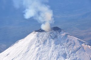
The weather is sunny in the morning and the evenings and afternoons are foggy. The smoke from the crater is observed white, thick, with a low gas pressure. The maximum height of 400 m is observed from the observation post of Mount Merapi in Kaliurang on November 29, 2018.
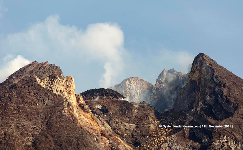
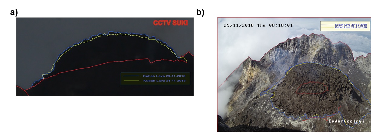
Dome of lava and morphology of the peak.
Morphological analysis based on photos of the Southeast sector showed morphological changes in the form of dome growth. Annex 1.a presents morphological analysis of the peak via the Deles camera station.
As of November 29, 2018, the volume of the lava dome was 329,000 m3 with an average growth rate of 2,500 m3 / day, about the same as the previous week. Currently, the lava dome is still stable with a low growth rate (<20,000 m3 / day). Appendix 1.b presents an analysis of the lava dome from the Puncak camera stations.
Seismicity.
This week, seismographs of Mount Merapi recorded 34 earthquakes (DG), 1 deep volcanic earthquake (VTA), 4 superficial volcanic earthquakes (VTB), 15 multiphase earthquakes (MPs), 309 earthquakes. avalanche (RF), 20 low frequency earthquakes (LF) and 5 tectonic earthquakes (TT). The intensity of the earthquakes this week is higher than the week before.
Deformation.
The deformation of G. Merapi, which was monitored by EDM and GPS this week, showed no significant change.
SO2 emissions.
During this week, the DOAS (Differential Optical Absorption Spectroscopy) measurement gave an average value of maximum SO2 emissions from Mount Merapi at 84.12 tons / day, still within normal limits.
Rain and lahars.
On November 29, 2018, at Pos Jrakah, it was raining at the observation post of Mount Merapi, with a rainfall intensity of 50 mm / hour for 75 minutes. There were no reports of lahar or increased flow in the rivers downstream of Mount Merapi.
CONCLUSION AND ADVICE
Conclusion
Based on the results of the visual and instrumental observations, it was concluded that:
1. The lava dome is currently in a stable state with a relatively low growth rate.
2. The volcanic activity of Mount Merapi is still quite high and is at the activity level « WASPADA ».
Suggestions.
With Mount Merapi’s activity level at « WASPADA » is recommended as follows to the stakeholders of Mount Merapi disaster management:
• An area with a radius of 3 km around the summit of Mount Merapi should be prohibited from activities of the population and climbing.
• If there is a significant change in Mount Merapi activity, Mount Merapi activity status will be re-examined.
• When it comes to the rainy season, people who move around the rivers below Mount Merapi are aware of the danger of the lahars.
• It is recommended that local authorities socialize the current state of Mount Merapi.
Source : Kepala Pusat Vulkanologi dan Mitigasi , Bencana Geologi, Kepala BPPTKG.
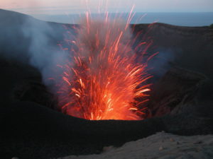
Video : Oystein Lund Andersen.
Cover Photo : Oystein Lund Andersen.
Alaska , Tectonic earthquake in Anchorage :
TECTONIC EARTHQUAKES AND ALASKA VOLCANOES
Tectonic earthquakes and Alaska volcanoes , Posted: November 30, 2018
Large tectonic earthquakes rarely trigger volcanic eruptions; this is an active area of research, but there are only a few convincing cases globally, and those are most likely to occur at volcanoes already in eruption or primed to erupt.
• The current eruptive activity at Veniaminof, and the unrest at Cleveland, Semisopochnoi, and Great Sitkin, continues without change since this morning’s large tectonic earthquake.
• AVO maintains ground-based networks for seismic and GPS monitoring of Alaska volcanoes, along with remote sensing methods such as satellite and infrasound.
• AVO’s volcano-monitoring networks also record tectonic earthquakes, and broaden the data set of all types of earthquakes, such as the tectonic earthquake experienced on the morning of 30 November 2018.
The M7.0 earthquake was tectonic and not volcanic:
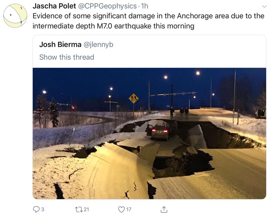
• The earthquake occurred at a depth of 24 miles beneath the surface (40 km).
• The earthquake occurred in the subduction zone – the interface between the Pacific and North America plates, which extends to depths of 24 to 37 miles (40 to 60 km).
• Subduction zones, where most active volcanoes are found, can generate high rates of earthquakes that are not volcanic.
• Aftershocks will occur.
• The Aleutian arc is a seismically active region, evidenced by the many moderate to large earthquakes occurring each year. Since 1900, this region has hosted twelve large earthquakes (M>7.5) including the May 7, 1986 M8.0 Andreanof Islands, The June 10, 1996 M7.9 Andreanof Islands, and the November 17, 2003 M7.8 Rat Islands earthquakes.
• The most recent large earthquake to occur in this area was the 2016 M7.1 Iniskin earthquake.
Source : AVO.
Colombia , Nevado del Huila :
Subject: Weekly activity bulletin of the Nevado del Huila volcano
The level of activity of the volcano continues at the level: yellow activity level or (III): changes in the behavior of volcanic activity.
According to the analysis and evaluation of the information obtained through the monitoring network of the Nevado del Huila volcano, during the week of 20 to 26 November 2018, the COLOMBIAN GEOLOGICAL SERVICE – Volatological and seismological observatory of Popayán indicates that :
• During the evaluated period, 381 seismic events were recorded, 140 related to rock fracturing processes (type VT) and 241 to fluid dynamics in volcanic canals. Of these 230 were classified as long-period type events (LP type), three (3) were related to both fracture mechanisms and fluid dynamics, so they were classified as hybrid types (HB type). ), and eight (8) as low energy tremor pulses (TR type).
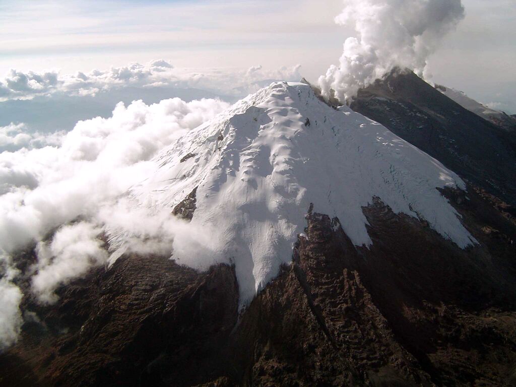
• The images obtained during the week by the web cameras of Caloto, Tafxnú, Maravillas and La Palma showed very low levels of degassing of the volcanic system.
Therefore, it is concluded that during the evaluated period, the volcano exhibited stable behavior.
Source : SGC.
Photo : SGC.
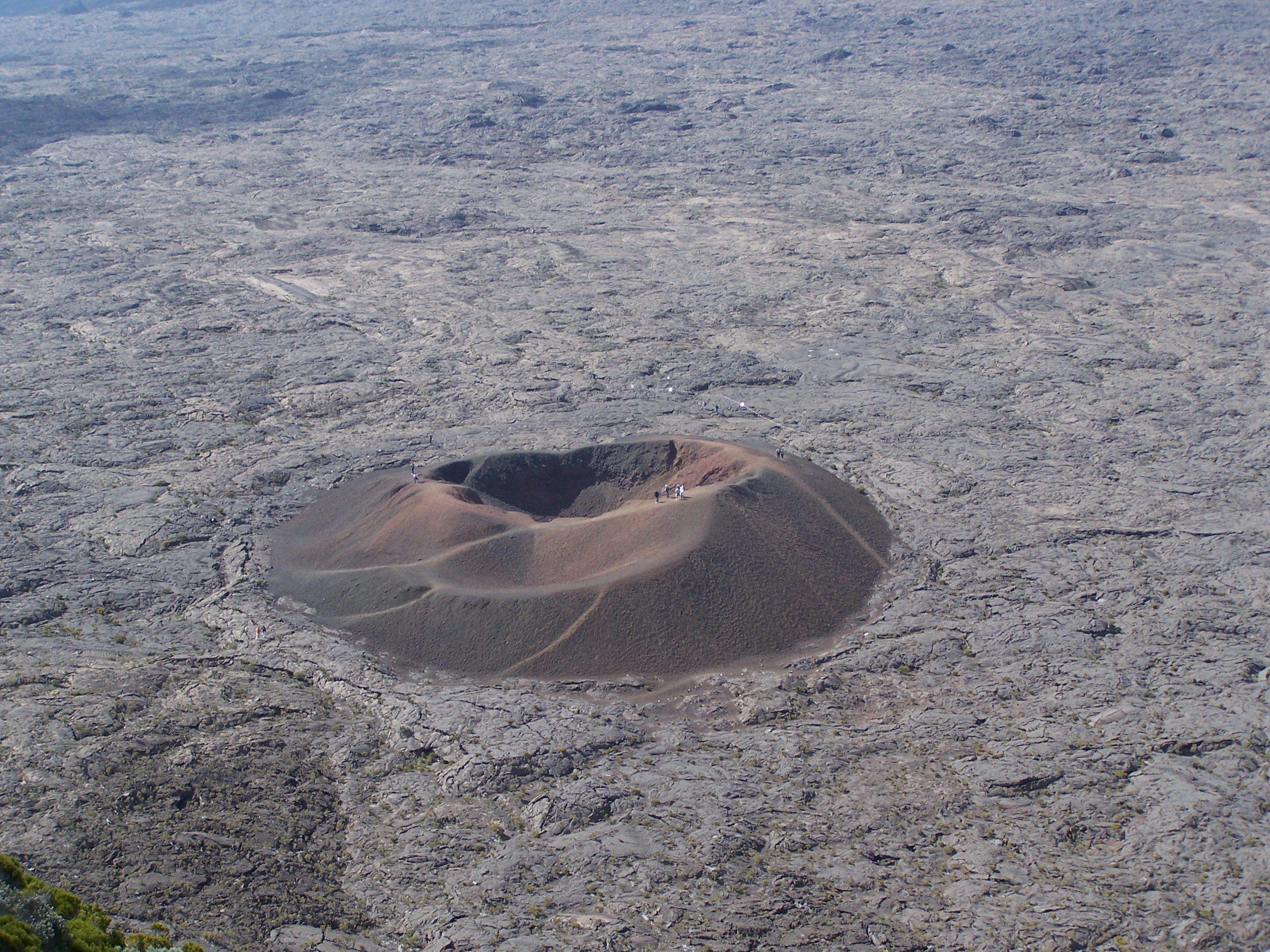
La Réunion , Piton de la Fournaise :
Seismicity.
Following the end of the eruption of 15 September – 1 November 2018, volcano-tectonic activity under the Piton de la Fournaise remained relatively low with an average of less than 1 superficial volcano-tectonic earthquake per day, and 2 deep earthquakes recorded throughout the month.
In November 2018, the OVPF recorded at the level of the Piton de la Fournaise massif in total:
• 20 superficial volcano-tectonic earthquakes (0 to 2 km deep) under the summit craters and under the northern flank;
• 2 deep earthquakes (> 2 km deep);
• 508 collapses (in the crater Dolomieu and at the ramparts of Enclos Fouqué).
Deformation.
Following the eruption eruption on November 1, 2018, the inflation of the building recorded since the end of September has stopped. Thus, OVPF deformation measurement networks recorded no significant deformation in November.
Gas geochemistry, CO 2 concentration in the soil.
– In the far field (Plaine des Cafres and Plaine des Palmistes sectors): following the steady decline in CO2 flows since May 2018, a new increase seems to be taking shape since October 26th. This trend will be confirmed in the coming weeks.
Balance sheet:
The month of November 2018 will have been marked in Piton de la Fournaise by a low seismicity under the summit craters and a stop of the inflation of the building. This testifies to the stopping (or at least slowing down) of the magmatic transfers from the deep zones to the more superficial zones. Moreover, the decrease in CO2 fluxes in the far-field soil since May 2018 suggests that the transfers of new magma towards the deep zones (mantle) seem to have ceased as well. Nevertheless, the trend reversal (ie an increase in CO2 fluxes in the far-field soil) observed since October 26, will be to follow in the coming weeks to determine whether a resumption of transfers of new magma to deep zones begins.
Source : OVPF.
Photo : G Vitton.
Philippines , Mayon :
MAYON VOLCANO BULLETIN 01 December 2018 08:00 A.M.
Mayon Volcano’s seismic monitoring network recorded five (5) volcanic earthquakes during the past 24 hours. One of these is related to an ash emission event that generated a grayish-white ash plume starting 09:41 AM yesterday, and lasted for 1 minute based on the seismic record before drifting southwest. Moderate emission of white steam-laden plumes that crept downslope before drifting west-southwest was observed. Sulfur dioxide (SO2) emission was measured at an average of 1377 tonnes/day on 30 November 2018. Precise leveling data obtained on 22-31 October 2018 indicate inflation of the edifice in the southeast sector while the north sector indicate short-term deflation relative to 30 August to 3 September 2018. The volcano generally remains inflated relative to 2010 baselines. Electronic tilt data further show pronounced inflation of the mid-slopes beginning 25 June 2018, possibly due to aseismic magma intrusion deep beneath the edifice.

Alert Level 2 currently prevails over Mayon Volcano. This means that Mayon is at a moderate level of unrest. DOST-PHIVOLCS reminds the public that sudden explosions, lava collapses, pyroclastic density currents or PDCs and ashfall can still occur and threaten areas in the upper to middle slopes of Mayon. DOST-PHIVOLCS recommends that entry into the six kilometer-radius Permanent Danger Zone or PDZ and a precautionary seven kilometer-radius Extended Danger Zone or EDZ in the south-southwest to east-northeast sector, stretching from Anoling, Camalig to Sta. Misericordia, Sto. Domingo must be strictly prohibited. People residing close to these danger areas are also advised to observe precautions associated with rockfalls, PDCs and ashfall. Civil aviation authorities must advise pilots to avoid flying close to the volcano’s summit as airborne ash and ballistic fragments from sudden explosions and PDCs may pose hazards to aircrafts.
Source : Phivolcs