
March 26 , 2022.
Philippines , Taal :
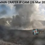
Taal Volcano Activity Bulletin, (UPDATE), March 26, 2021, 8:00 a.m.
Everyone is aware of Taal Volcano’s alert level being raised from Alert Level 2 (increased activity) to Alert Level 3 (magmatic unrest). At 7:22 a.m., there was a brief phreato-magmatic burst in the main crater of Taal Volcano followed by an almost continuous phreato-magmatic eruption that created a one thousand five hundred (1500) meter high plume with tremors volcanic and infrasonic signals.
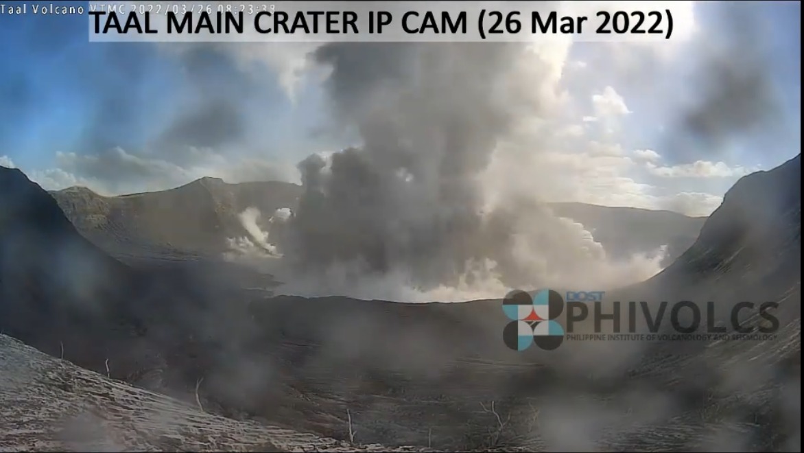
Currently, DOST-PHIVOLCS is raising the alert status of Taal Volcano from Alert Level 2 (increased activity) to Alert Level 3 (magmatic unrest). In this situation, magma rising towards the floor of the main crater could cause an additional or strong eruption. DOST-PHIVOLCS strongly urges everyone to evacuate from Taal Volcano Island or TVI and the high risk barangays of Bilibinwang and Banyaga, Agoncillo and Boso-boso, Gulod as well as the eastern part of Bugaan East, Laurel, Batangas due to the danger of pyroclastic density currents and volcanic tsunamis in the event of a strong eruption. Everyone is strongly reminded that all of TVI is a Permanent Danger Zone (PDZ) and that access to it and the high-risk barangays of Agoncillo and Laurel should be prohibited. All activities on Lake Taal are to be prohibited for the time being. Residents around Taal Lake are encouraged to be alert and cautious due to possible ash and vog fall and to be always prepared for possible evacuation should Taal activity deteriorate. Civil aviation officials should urge pilots to avoid flying near the volcano due to emitted ash, rocks and pyroclastic density currents that could affect aircraft caused by a possible sudden volcanic eruption. DOST-PHIVOLCS is closely monitoring the status of Taal Volcano 24/7 and is ready to immediately notify all concerned of any changes.
Source : Phivolcs.
Azores , São Jorge :
CIVISA has raised the volcano alert to 4 on a 5-point scale due to strong seismic activity that has occurred on the island over the past week. The civil protection agency has activated its regional emergency plan. The government is preparing to evacuate around 5,000 people from the municipality of Velas as plans are underway to relocate vulnerable people among the worst affected population. Scientists from CIVISA, the civil defense agency tasked with monitoring seismic activity, said they plan to deploy additional equipment to measure signs of volcanic activity. It is possible that this swarm was created by the movement of magma just below the surface, which could be a sign that a volcanic eruption could occur in the days or weeks to come.
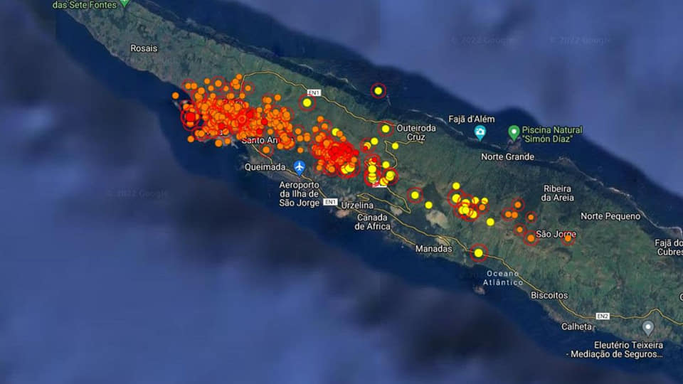
Earthquakes felt on São Jorge Island (Status Update, March 24, 2022, 10:00 p.m.)
The Azores Seismo-Volcanic Information and Monitoring Center (CIVISA) reports that seismic activity has been recorded since 4:05 p.m. (local time = UTC-1) on March 19 in the central part of the island of São Jorge, more precisely along an area oriented West-North-West / East-South-East, in a sector between Velas and Fajã do Ouvidor. She continues above normal.
The strongest earthquake occurred on March 19 at 6:41 p.m. (local time = UTC-1) and had a magnitude of 3.3 (Richter).
Several earthquakes were felt by the population. From 10:00 a.m. to 10:00 p.m. on March 25, 7 earthquakes were felt.
« Small deformations in the ground, which did not exist at the beginning of the week », have been detected in the area of the island of São Jorge « where more earthquakes occur », revealed Nuno Dias, specialist in seismology .
Sources : weatherboy.com , mobile.twitter.com/MeteoTrasMon.
Photo : GEVolcan.
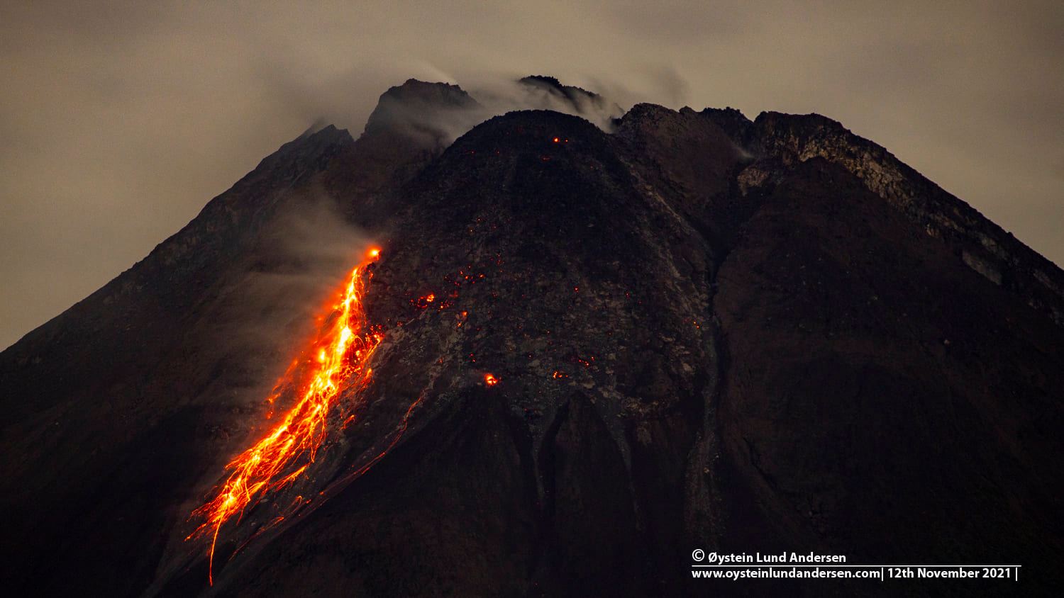
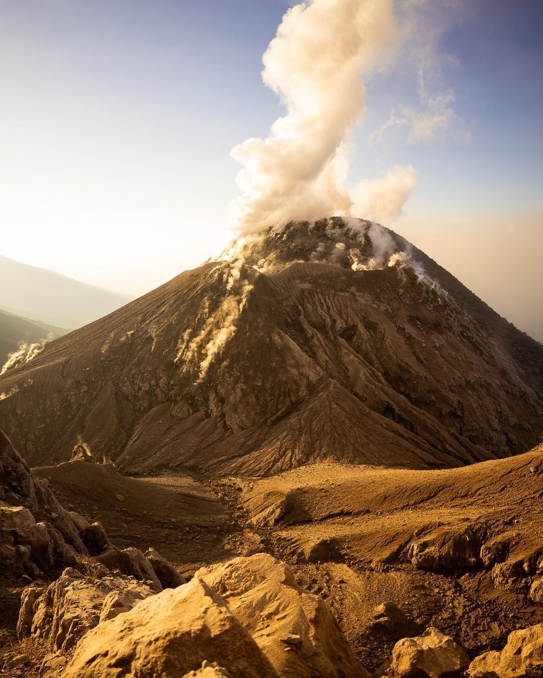
Indonesia , Merapi :
Report on the activity of Mount Merapi from March 18 to 24, 2022
Posted on March 25, 2022
RESULTS OF OBSERVATIONS
Visual
The weather around Mount Merapi is usually sunny in the morning and evening, while it is foggy in the afternoon. White, weak to thick, low pressure, 100m high smoke was observed from the Mount Merapi Ngepos observation post on March 22, 2022 at 05:30 WIB.
This week there were 6 hot avalanches with an estimated slip distance of 2,500 m. It was reported that there was light ash rain in Selo district. Lava avalanches were observed 51 times to the southwest, descending the Bebeng River with a maximum slip distance of 2,000 m.
In the Southwest dome, the height has increased by about 4 m. For the central dome, no significant morphological change was observed. Based on photo analysis, the volume of the Southwest lava dome is 1,609,000 m3 and the central dome is 2,582,000 m3.
Seismicity
This week, the seismicity of Mount Merapi recorded:
6 earthquakes of hot cloud avalanches. (APG),
25 shallow volcanic earthquakes (VTB),
84 multi-phase earthquakes (MP),
2 low frequency earthquakes (LF),
592 avalanche earthquakes (RF),
8 emission earthquakes (DG),
9 tectonic earthquakes (TT).
The intensity of seismicity this week was higher than last week.
Deformation
Mount Merapi’s deformation, which was monitored using EDM this week, showed a distance shortening rate of 0.3 cm/day.
Rain and lahars
This week, it rained at Mount Merapi observation post with an intensity of 68 mm/hour for 40 minutes at Kaliurang post on March 21, 2022. It was reported that there was a lahar in the Boyong River on March 20, 2022.
Conclusion
Based on the results of visual and instrumental observations, it is concluded that:
Volcanic activity at Mount Merapi is still quite high in the form of effusive eruption activity. The state of the activity is defined at the « SIAGA » level.
Source : BPPTKG.
Photo : Oystein Lund Andersen.
Alaska , Great Sitkin :
52°4’35 » N 176°6’39 » W,
Summit Elevation 5709 ft (1740 m)
Current Volcano Alert Level: WATCH
Current Aviation Color Code: ORANGE
Lava effusion from a vent within the summit crater of Great Sitkin Volcano continued at a slow rate over the last week. Erupted lava has overtopped the summit crater rim and is flowing into small valleys on the south, west, and north flanks of the volcano. Clouds obscured views of the volcano most of the week, but elevated surface temperatures were detected on March 21, and analysis of a satellite radar image collected March 22 suggests continued extrusion in all directions around the vent and slow advance of the southern lobe. Seismic activity remains low.
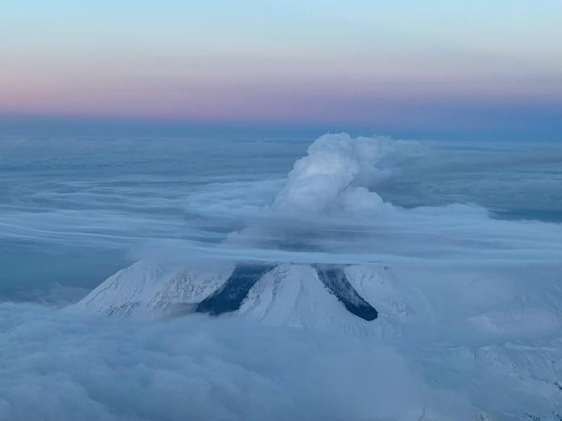
Terrain is steep near the terminus of the lava flow lobes, and blocks of lava could detach without warning and form small rock avalanches in these valleys. One such avalanche from the southern crater rim flow front was observed in satellite data from March 22, 2022. These avalanches may liberate ash and gas and could travel several hundred meters beyond the lava flows; they would be hazardous to anyone in those areas.
Great Sitkin is monitored by local seismic and infrasound sensors, satellite data, web cameras, and remote infrasound and lightning networks.
Source : AVO.
Photo : McConnell, Angela
Guatemala , Santiaguito :
Activity:
The Santiaguito volcano observatory reports white degassing 300 meters above the crater which extends to the south and southwest. At night, incandescence was observed in the crater of the Caliente dome and in the lava flows in the west and south-west directions. Weak avalanches of blocks and ash continue to be recorded on the West, South-West and South flanks, these avalanches reaching the base of Dome Caliente.
The volcano maintains high activity due to blocky lava extrusion into the dome in a west-southwest direction and unstable material within the crater. There is a likelihood of moderate to strong pyroclastic flows, so do not stay near or in riverbeds near the slopes of the volcano. The recommendations of BESAN bulletin n° 003-2022 are still valid.
Source : Insivumeh.
Photo : kyle weinstein photography


No comment yet, add your voice below!