August 21 , 2021 .
Indonesia , Merapi :
Report on the activity of Mount Merapi from August 13 to 19, 2021
RESULT OF OBSERVATIONS
Visual
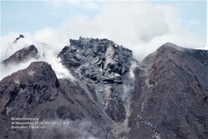
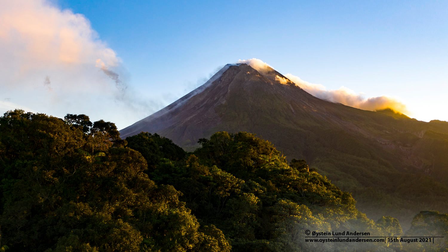
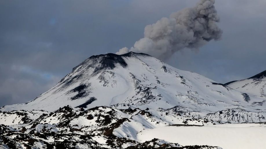
The weather around Mount Merapi is generally sunny in the morning and evening, while it is foggy in the afternoon. White fumes, weak to thick, of low pressure and 400m high were observed from the Mount Merapi observation post in Selo on August 18, 2021 at 07:00 WIB.
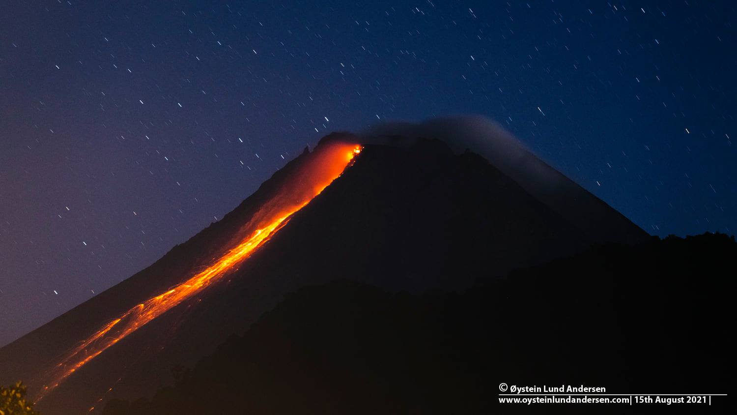
This week, there were 20 hot clouds of southwest trending avalanches with a maximum slide distance of 3,500 m. 172 lava avalanches were observed towards the southwest with a maximum sliding distance of 2000 m.
Ash rains were reported in several areas on August 16, 2021, including Dukun, Sawangan, Tegalrejo, Secang, Gowok, Mertoyudan, Selo, Mojotengah, Temanggung, Kedu, Pringsurat, Bulu, Tlogomulyo, Kranggan, Parakan.
It was observed that there were morphological changes in the southwest lava dome due to avalanches and hot clouds, while the central dome remained relatively constant. The volume of the southwest lava dome is 1,350,000 m3.
Seismicity
This week, the seismicity of Mount Merapi showed:
20 hot cloud avalanche earthquakes (AP),
79 shallow volcanic earthquakes (VTB),
3 low frequency earthquakes (LF),
228 multi-phase earthquakes (MP),
1969 Avalanche earthquakes (RF),
82 emission earthquakes (DG),
4 tectonic earthquakes (TT).
This week’s seismicity intensity was lower than last week.
Deformation
The deformation of Mount Merapi, which was monitored using EDM this week, showed a distance shortening rate of 1.9 cm / day.
Rain and lahars:
This week, it rained at the Mount Merapi observation post with an intensity of 25 mm / hour for 160 minutes at Kaliurang post on August 18, 2021. There were no reports of lahars or additional flow in the mountains. rivers that take their source on Mount Merapi.
Conclusion
Based on the results of visual and instrumental observations, it is concluded that:
The volcanic activity of Mount Merapi is still quite high in the form of effusive eruption activity. The status of the activity is defined in the “SIAGA” level.
Source : BPPTKG.
Photos : Øystein Lund Andersen.
Kamchatka , Sheveluch :
VOLCANO OBSERVATORY NOTICE FOR AVIATION (VONA).
Issued: August 20 , 2021
Volcano: Sheveluch (CAVW #300270)
Current aviation colour code: ORANGE
Previous aviation colour code: orange
Source: KVERT
Notice Number: 2021-98
Volcano Location: N 56 deg 38 min E 161 deg 18 min
Area: Kamchatka, Russia
Summit Elevation: 3283 m (10768.24 ft), the dome elevation ~2500 m (8200 ft)
Volcanic Activity Summary:
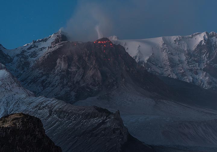
The growth of the lava dome continues, a strong fumarolic activity, and an incandescence of the lava dome and hot avalanches accompanies this process. Satellite data showed a gas-steam plume containing some amount of ash extending 86 km to the east-south-east from the volcano.
This eruption persist. Ash explosions up to 10-15 km (32,800-49,200 ft) a.s.l. could occur at any time. Ongoing activity could affect international and low-flying aircraft.
Volcanic cloud height:
4000 m (13120 ft) AMSL Time and method of ash plume/cloud height determination: 20210820/2110Z – Himawari-8
Other volcanic cloud information:
Distance of ash plume/cloud of the volcano: 86 km (53 mi)
Direction of drift of ash plume/cloud of the volcano: ESE / azimuth 109 deg
Time and method of ash plume/cloud determination: 20210820/2110Z – Himawari-8
Source : Kvert.
Photo : Tom Pfeiffer / VolcanoDiscovery)
Philippines , Taal :
TAAL VOLCANO BULLETIN , 21 August 2021 8:00 AM
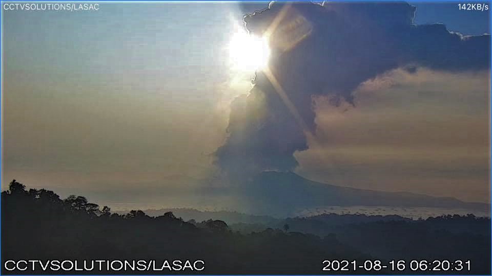
In the past 24-hour period, the Taal Volcano Network recorded one hundred thirty-five (135) volcanic earthquakes, including one hundred twelve (112) volcanic tremor events having durations of one (1) to one hundred ten (110) minutes, twenty-three (23) low-frequency volcanic earthquakes, and low-level background tremor that has persisted since 07 July 2021. Activity at the Main Crater was dominated by upwelling of hot volcanic fluids in its lake which generated plumes 3,000 meters tall that drifted southwest and northeast.
Vigorous upwelling at the Taal Main Crater lake generated steam-rich plumes 3,000 meters tall this morning. Volcanic smog has been experienced over the Taal region this week as high levels of volcanic SO₂ that peaked on 19 August at an average of 12,257 tonnes/day have been continually degassed from the Main Crater. Persistent degassing since yesterday afternoon has produced volcanic smog that continues to envelop and cause poor visibility across the Taal region today. Alert Level 2 prevails over Taal Volcano.
Sulfur dioxide (SO2) emission averaged 4,756 tonnes/day on 20 August 2021. In addition, vog was observed over Taal Volcano and vicinity. Based on ground deformation parameters from electronic tilt, continuous GPS and InSAR monitoring, Taal Volcano Island has begun deflating in April 2021 while the Taal region continues to undergo very slow extension since 2020.
Source : Phivolcs .
Photo : CCTV
Chile , Nevados de Chillan :
The seismicity parameters associated with rigid material fracturing (VT) processes and fluid dynamics (LP, VLP, TR and EX types) have remained at similar values, although with some alternation in the levels of energy released.
The highest energy VT-type event, with a local magnitude (ML) of 1.9, was located 4.1 km east (E) of the active crater and at a depth of 4.6 km.
From the analysis of the images provided by the surveillance cameras belonging to the OVDAS as well as the satellite images, we observe that the emission of the L5 and L6 flows has been maintained, whose fronts reach 1277 m and 850 m. from the edge of the crater. The maximum velocity of the L5 lava flow showed an increase for this period reaching 1.2 m / h, while the L6 flow did not show any progression during the fortnight. During this fortnight the supply of the L5 lava flow in fresh matter was identified by the central channel towards the lava front. Both lava flows exhibit a high degree of instability, with collapses in the middle and distal part being common.
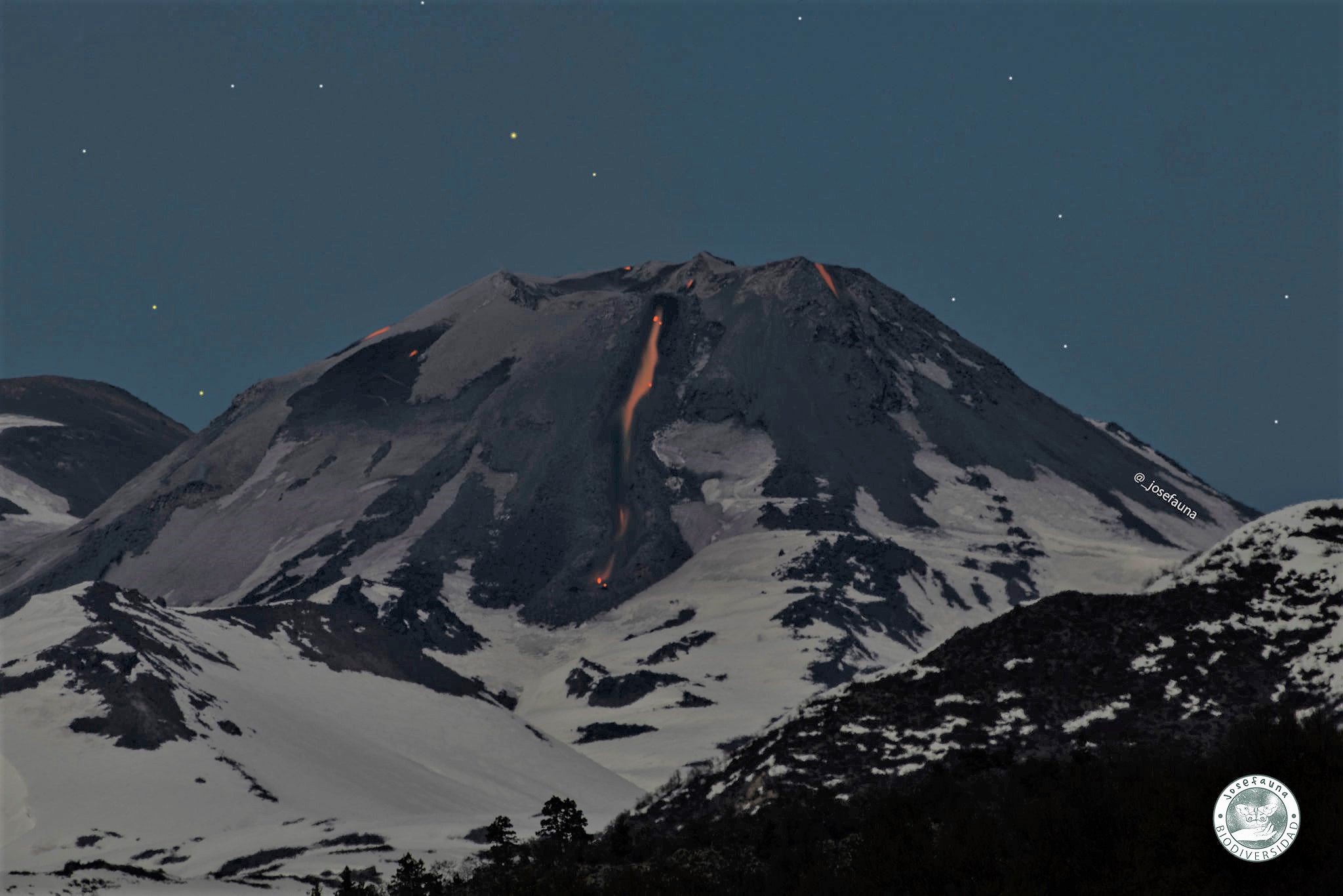
The explosive activity featured maximum column heights of 1480 m, with recurring high pyroclast explosions. An increase in the recurrence of explosions, collapses and proximal pyroclastic flows was observed between August 8 and 13, mainly affecting the eastern edge (E) of the active crater, with a maximum range of 570 m from the edge of the crater. . the paths to the North (N) and North-East (NE) slopes were 450 m and 270 m respectively.
A high level of intensity, distribution and frequency of incandescent events associated with explosions with falling incandescent blocks that affect the North, East, West and South slopes, with a maximum range of 500 m, has been maintained.
According to data obtained by the network of GNSS stations installed on the volcano, stabilization was observed, showing deformation trends going towards zero. The monitoring baselines between GNSS stations and inclinometer stations remained stable during this period.
Thirty-one (31) thermal alerts were recorded in the area with a maximum value of 63 MW on August 13, considered moderate for this volcano. In turn, radiance anomalies were detected on August 2, 4, 7, 9, 12 and 14 from Sentinel 2-L2A image analysis.
The thermal imaging made it possible to observe maximum temperatures of 302 ° C in the emission zone during the explosions, 262 ° C for the L5 flow and 301 ° C for L6. An increase in temperature for the L5 flow was evident during August 11 associated with changes in flow velocity. The decrease in temperature of the L6 lava flow over the past fortnight is consistent with the absence in the records of new pulses in it.
Source : Segemar .
Photos : Josefauna , losandes.com.ar .
Guatemala , Fuego :
ACTIVITY:
OVFGO observers report that the volcanic complex woke up cloudy. During the night and early in the morning, weak white fumaroles were observed which rise 4500 meters above sea level. Weak to moderate explosions accompanied by ash were observed in a range of 7 to 12 per hour which rose to a height of 4,500 to 4,800 meters above sea level (14,764 to 15,748 feet) dispersing in a westerly and southwest direction, generating ash falls in the areas of Panimaché 1 and 2, Santa Sofía, El Porvenir, Yepocapa and others in the region.
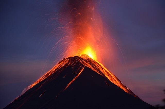
Incandescent pulses were observed rising 100 to 300 above the crater, accompanied by faint white fumaroles. Some of the explosions generate weak, moderate and some loud rumbles that generate vibrating shock waves on roofs and windows within a radius of 20 kilometers, in the villages of the western and southwest flanks. Constant boulder avalanches were heard towards the ravines of Ceniza, Taniluya, Trinidad and Santa Teresa, some of the material reached the edge of the vegetation. Train locomotive noise is reported for periods of 1 to 3 minutes.
Source : Insivumeh .
Photo : nath Duverlie , 05/05/219