December 01 , 2020.
Indonesia , Semeru :
VOLCANO OBSERVATORY NOTICE FOR AVIATION – VONA.
Issued : November 30 , 2020
Volcano : Semeru (263300)
Current Aviation Colour Code : ORANGE
Previous Aviation Colour Code : orange
Source : Semeru Volcano Observatory
Notice Number : 2020SMR117
Volcano Location : S 08 deg 06 min 29 sec E 112 deg 55 min 12 sec
Area : East java, Indonesia
Summit Elevation : 11763 FT (3676 M)
Volcanic Activity Summary :
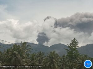
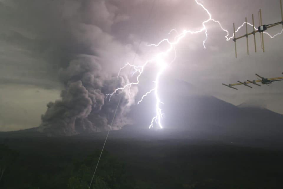
Eruption with volcanic ash cloud at 19h45 UTC (01h45 local). Eruption and ash emission is continuing.
Volcanic Cloud Height :
Best estimate of ash-cloud top is around 18163 FT (5676 M) above sea level, may be higher than what can be observed clearly. Source of height data: ground observer.
Other Volcanic Cloud Information :
Ash-cloud moving to east
Surveillance data:
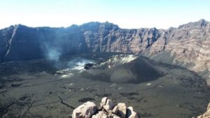
1. Visual: From October 1 to November 30, 2020, the volcano was clearly visible until it was covered in fog. The crater was emitting white / gray smoke with low / medium intensity, about 50-500 meters above the summit. The weather is sunny to rainy, with weak to strong winds in the North, North-East, East, South, South-West and West. The air temperature is around 19-32 ° C. Eruptions have occurred continuously, resulting in columns of gray eruptions with a height of up to 500m from the top of the crater / peak.
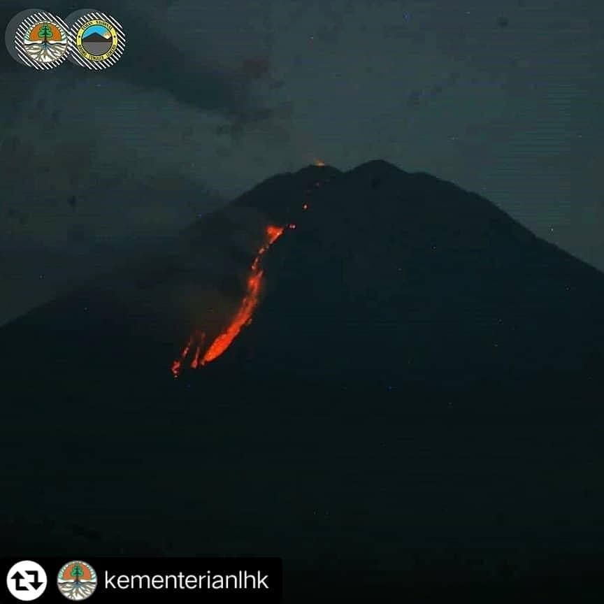
Rock avalanches from the summit have occurred continuously since October 19, 2020. On November 28, there was a significant increase in the number of avalanches, followed by the appearance of hot avalanche clouds from the tip of the lava tongue with a maximum sliding distance of 1 km towards the south-eastern sector of the flanks. On December 1, 2020, from 01.23, hot clouds were observed descending from the summit dome, with a sliding distance of 2 to 11 km towards Besok Kobokan in the south-eastern sector of the summit of Mount Semeru.
2. Seismicity: The number and type of earthquakes recorded from October 1 to November 30, 2020 were dominated by eruptive earthquakes with an average of 40 events per day. On November 20, 2020, the number of eruption earthquakes tends to decrease and there is an increase in the number of earthquakes. Emission earthquakes occur with an average of 10 events per day, while volcanic earthquakes (deep volcanic earthquakes, shallow volcanic earthquakes and tremors) are recorded at very low numbers.
Analysis:
Visual observations indicate an increase in the number of seismic avalanches and several descents of hot clouds. This increase is caused by the instability of the lava dome at the top. The seismicity until December 1, 2020 at 6:00 a.m. was dominated by avalanche earthquakes and several hot cloud avalanche earthquakes.
Potential danger:
The potential threat of the Mount Semeru eruption comes in the form of glowing rocks throwing around the summit, while ejection material (ash) can spread further depending on the direction and speed of the wind. Other potential hazards are hot avalanche clouds and lava spit dome / tip rock avalanches in the southeast and south sectors of the summit. If it is raining there may be lahars along the river coming down from the summit.
Conclusion:
Based on the results of visual and instrumental monitoring, as well as the potential dangers, G. Semeru’s activity level is always set at level II (WASPADA).
Recommendation:
In Level II status (WASPADA) people / visitors / tourists must not have activities within a radius of 1 km around the crater / summit of Mount Semeru and at a distance of 4 km in the direction of the opening of the crater in the South-South-East sector, as well as to be aware of the hot clouds of avalanches, lava avalanches and lahars along the river / valley which originates at the top of Mount Semeru . The radius and recommended distance will be continuously evaluated in anticipation of any change in hazard symptoms.
Level of activity level II (WASPADA). The Semeru (3,676 m above sea level) is continuously erupting.
On December 1, 2020, from 01.23, hot clouds were observed descending with a sliding distance of 2 to 11 km towards Besok Kobokan in the southeast sector of Mount Semeru.
According to the seismographs of November 30, 2020, it was recorded:
3 eruption / explosion earthquakes
1 hot cloud avalanche earthquakes
2 emission earthquakes
4 harmonic earthquakes
1 distant tectonic earthquake
Source : Magma Indonésie , PVMBG.
Photos : Badan Geologi , PusatPengendalian Pembangunan EkoregionJawa , Aris Yanto ( 28 / 11) .
Nicaragua , Telica :
The Telica volcano, located in the department of León, recorded small explosions with gas and ash fumes on Monday morning. Nicaraguan Vice President Comrade Rosario Murillo reported that the volcano started activity at 5:40 a.m.
Until noon on Monday, the Telica volcano had recorded 50 explosions with columns of gas and ash that reached heights of 100 to 400 meters above the crater of the volcano.
The Nicaraguan Institute of Territorial Studies (INETER) clarified that these explosions do not represent any danger for the families of the communities surrounding the volcano.
Last July, the Telica volcano recorded 27 explosions with gas and ash fumes, with no trace of damage.
The Telica volcano is located in the Los Maribios mountain range, at an altitude of 1060 meters and acquires its name because it is located in the municipality of Telica, in the department of León.
Source : nuevaya.com.ni.
Photo : Jaime Incer,
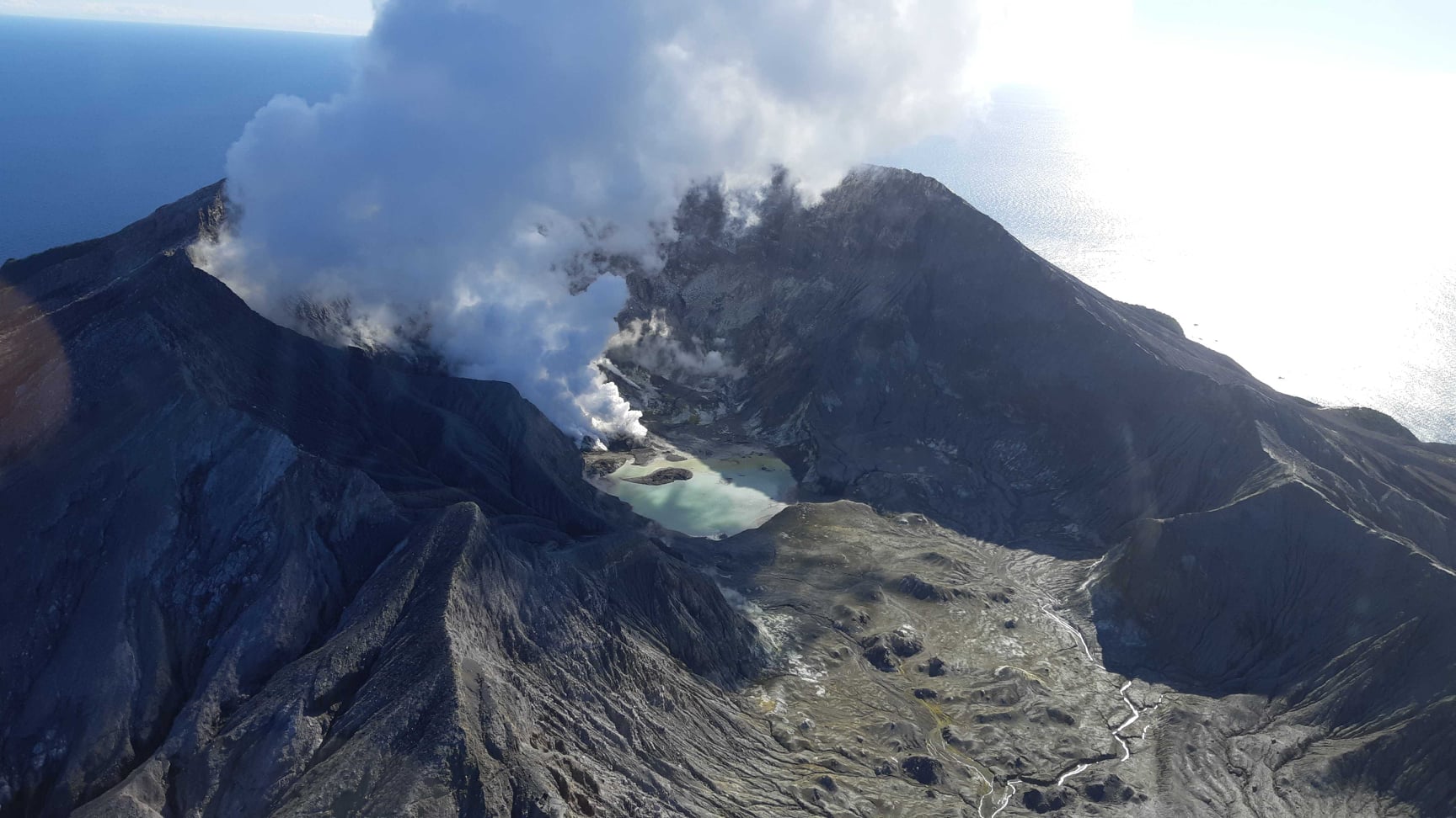
New Zealand , White Island :
Ash emission has reduced at Whakaari/White Island. Volcanic Alert Level remains at Level 2.
Camera images from Whakaari/White Island appear to show that ash is no longer present in the near-persistent steam and gas plume. The amounts of CO2 and SO2 gas remain elevated. The Volcanic Alert Level remains at Level 2.
Over the past three weeks, ash has been emitted from the main vent at the back of the lake at Whakaari/White Island. Based on camera footage, aerial observations and gas measurement flights, the amount of ash in the plume appears to have diminished over the last week. This is consistent with the lack of ash being detected on recent MetService satellite images. The plume is now back to its light colour, composed of steam and volcanic gas, with little to no ash. There remains some uncertainty in this observation due to some ash coating the camera lenses, contributing to a slightly blurred image.

Gas-measuring and observation flights will be attempted this week to confirm these observations and determine if the amount of volcanic gases has changed in the current plume. The most recent gas flights found that the main volcanic gases (CO2 and SO2) were elevated above normal levels.
The last two weeks has seen the number of discrete volcanic earthquakes reduce to low levels, with no further earthquakes since our last bulletin on Tuesday 17 November 2020. Volcanic tremor remains weak.
Whakaari/White Island remains in a period of heightened unrest. As a result, the Volcanic Alert Level remains at Level 2 and the Aviation Colour Code remains at Yellow.
The Volcanic Alert Level reflects the current level of volcanic unrest or activity and is not a forecast of future activity. Volcanic Alert Level 2 indicates the primary hazards are those expected during volcanic unrest; discharge of steam and volcanic gas, earthquakes, landslides and hydrothermal activity. While Volcano Alert Level 2 is mostly associated with environmental hazards, eruptions can still occur with little or no warning.
GNS Science and our National Geohazards Monitoring Centre continuously monitor Whakaari/White Island for changes in activity. Further updates will be provided as needed.
Source : Geonet / Geoff Kilgour Duty Volcanologist .
Photos : Geonet . ( 16/11/2020) . Geonet (29/07/2020).
Peru , Sabancaya :
Analysis period: November 23 to 29, 2020, Arequipa, November 30, 2020.
Alert level: ORANGE
The Geophysical Institute of Peru (IGP) reports that the eruptive activity of the Sabancaya volcano remains at moderate levels, that is, with the continuous recording of explosions with columns of ash and gas up to 4 km altitude above the summit of the volcano and their consecutive dispersion. Therefore, for the following days, no significant change is expected in the eruptive activity.
The IGP recorded and analyzed the occurrence of 2335 earthquakes of volcanic origin, associated with the circulation of magmatic fluids inside the Sabancaya volcano. An average of 49 explosions were recorded daily of low to medium intensity. During this period, Volcano-Tectonic (VT) earthquakes were located mainly in the North-East of Sabancaya and presented magnitudes between M1.6 and M3.6. The most representative earthquake (M3.6) was recorded on November 26 at 12:44 p.m. 6 km northeast of Sabancaya and 11 km deep.
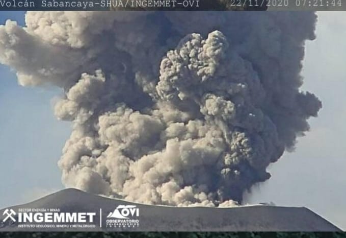
The monitoring of the deformation of the volcanic structure using GNSS techniques (processed with fast orbits) does not present any significant anomalies. However, in general, an inflation process has been observed in the south-eastern sector of Sabancaya and the north sector (Hualca Hualca volcano). The visual surveillance made it possible to identify columns of gas and ash up to 4 km altitude above the summit of the volcano, which were dispersed towards the North-West, West, South-West and South sectors of Sabancaya. It has been reported the presence of ash falls in the district of Lluta and Huambo. Satellite monitoring has identified the presence of 7 thermal anomalies with values between 1 MW and 63 MW, associated with the presence of a lava body on the surface of the volcano crater.
RECOMMENDATIONS
• Keep the volcanic alert level in orange.
• Do not approach within a radius of less than 12 km from the crater.
Source : IGP.
Photo : Observatorio Vulcanológico INGEMMET @ingemmet.peru