June 29 , 2020 .
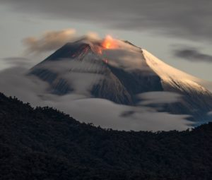
Alaska , Makushin :
53°53’24 » N 166°55’30 » W,
Summit Elevation 5906 ft (1800 m)
Current Volcano Alert Level: ADVISORY
Current Aviation Color Code: YELLOW
Occasional small earthquakes continue at Makushin from an earthquake sequence that started on June 16. Clouds blocked views of the volcano in satellite and web camera images over the past day.
Makushin summit hike by Jacob Whitaker, August 8, 2019.
This earthquake sequence may be associated with volcanic unrest, but there have been no signs of deformation or surface activity noted in other monitoring data. It is likely that we would see additional signs of unrest prior to an eruption, should it occur. The volcano is monitored with a network of seismic and GPS instruments, a web camera, satellite data, and regional infrasound and lightning detection instruments.
If an eruption were to occur, the main hazard would likely be from airborne ash and ash fall. Wind trajectory plots and hypothetical ash fall model information is available at https://www.avo.alaska.edu/activity/Makushin.php These models are updated twice per day in a hypothetical mode and will be updated immediately if there is an eruption. Seismic data, web camera images, and information products are also available at this site.
Source : AVO.
Photo : Whitaker, Jacob.
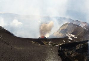
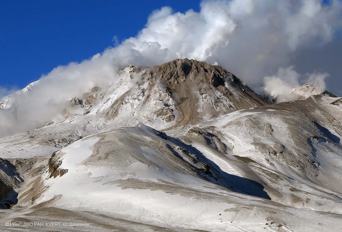
Kamchatka , Sheveluch :
VOLCANO OBSERVATORY NOTICE FOR AVIATION (VONA).
Issued: June 28 , 2020
Volcano: Sheveluch (CAVW #300270)
Current aviation colour code: ORANGE
Previous aviation colour code: orange
Source: KVERT
Notice Number: 2020-144
Volcano Location: N 56 deg 38 min E 161 deg 18 min
Area: Kamchatka, Russia
Summit Elevation: 10768.24 ft (3283 m), the dome elevation ~8200 ft (2500 m)
Volcanic Activity Summary:
A growth of the lava dome continues, a strong fumarolic activity sometimes with some amount of ash, and an incandescence of the dome blocks and hot avalanches accompanies this process. A re-suspended ash extended about 140 km to the east from the volcano.
This eruption continues. Ash explosions up to 32,800-49,200 ft (10-15 km) a.s.l. could occur at any time. Ongoing activity could affect international and low-flying aircraft.
Volcanic cloud height:
8200-9840 ft (2500-3000 m) AMSL Time and method of ash plume/cloud height determination: 20200628/0030Z – NOAA 18 (4m5)
Other volcanic cloud information:
Distance of ash plume/cloud of the volcano: 87 mi (140 km)
Direction of drift of ash plume/cloud of the volcano: E / azimuth 95 deg
Time and method of ash plume/cloud determination: 20200628/0030Z – NOAA 18 (4m5)
Source : Kvert .
Photo : Yu. Demyanchuk, IVS FEB RAS, KVERT.
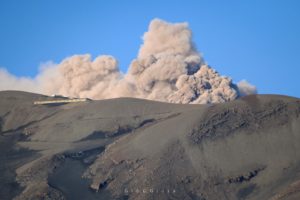
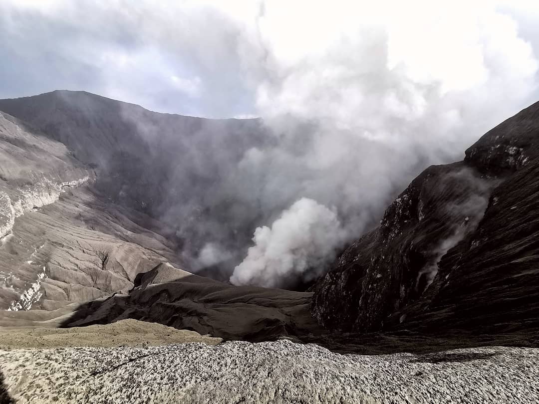
Philippines , Kanlaon :
KANLAON VOLCANO BULLETIN 29 June 2020 08:00 A.M.
Kanlaon Volcano’s seismic monitoring network recorded sixteen (16) volcano-tectonic earthquakes on the western flanks and four (4) volcanic earthquakes in the summit area during the 24-hour observation period. Moderate emission of white steam-laden plumes that rose 300 meters before drifting northeast and northwest was observed. Sulfur dioxide (SO2) emission was measured at an average of 116 tonnes/day on 27 June 2020. Ground deformation data from continuous GPS measurements indicate a slight deflation of the lower and mid slopes since January 2020. However, short-term electronic tilt monitoring on the southeastern flanks recorded inflation on the lower to mid slopes that began on June 21, 2020. These parameters indicate hydrothermal or magmatic processes occurring beneath the edifice.

DOST-PHIVOLCS would like to remind the public that Kanlaon Volcano is at Alert Level 1, which means that it is at an abnormal condition and has entered a period of unrest. The local government units and the public are strongly reminded that entry into the 4-kilometer radius Permanent Danger Zone (PDZ) must be strictly prohibited due to the further possibilities of sudden and hazardous steam-driven or phreatic eruptions. Civil aviation authorities must also advise pilots to avoid flying close to the volcano’s summit as ejecta from any sudden phreatic eruption can be hazardous to aircraft. DOST-PHIVOLCS is closely monitoring Kanlaon Volcano’s activity and any new development will be relayed to all concerned.
Source : DOST-PHIVOLCS.
Photo : Phivolcs .
Indonesia , Dukono :
VOLCANO OBSERVATORY NOTICE FOR AVIATION – VONA
Issued: June 28 , 2020
Volcano :Dukono (268010)
Current Aviation Colour Code: ORANGE
Previous Aviation Colour Code : orange
Source: Dukono Volcano Observatory
Notice Number: 2020DUK53
Volcano Location :N 01 deg 41 min 35 sec E 127 deg 53 min 38 sec
Area:North Maluku, Indonesia
Summit Elevation :3933 FT (1229 M)
Volcanic Activity Summary:
Eruption with volcanic ash cloud at 22h32 UTC (07h32 local).
Volcanic Cloud Height:
Best estimate of ash-cloud top is around 5533 FT (1729 M) above sea level, may be higher than what can be observed clearly. Source of height data: ground observer.
Other Volcanic Cloud Information:
Ash-cloud moving to west.
Remarks:
Eruption and ash emission is continuing.
Source : Magma Indonésie .
Photo : Rainwater Media via Sherine France.
Ecuador , Sangay :
DAILY REPORT OF THE STATE OF SANGAY VOLCANO, Sunday June 28, 2020.
Surface activity level: High, Surface trend: No change.
Internal activity level: High, Internal trend: No change.
Seismicity: From June 27, 2020, 11:00 a.m. to June 28, 2020, 11:00 a.m .:
Long-term events: 19
Explosions: 168
Transmission tremor: 4
Rains / lahars: Sporadic rains were reported, which did not generate lahars. The eruptive activity accumulates significant quantities of pyroclastic material on the sides of the Sangay volcano, which can trigger the descent of mudslides and debris (lahars). It is recommended not to approach rivers in the area. * In the event of heavy rain, lahars can be generated in the Volcán, Upano and other tributaries. *
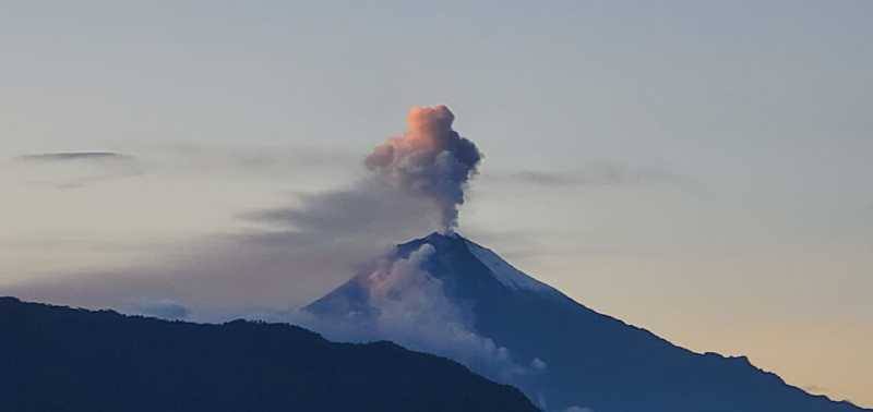
Emission / ash column: A gas and ash emission was observed with a maximum height of 1500 meters above the summit dispersing in a northwest direction. The Washington VAAC reported gas and ash emissions with heights between 870 and 1170 meters above the summit in a west and northwest direction. There have been no reports of ash falling
Other monitoring parameters: No changes.
Observations: The volcanic sector cleared at the end of the afternoon yesterday, the rest of the time, it remained mainly cloudy.
Alert level: yellow.
Source : IGEPN.
Photo : el universo