May 27 , 2020 .
Peru : Ubinas ,
Volcanic analysis period: May 18 to 24, 2020 Arequipa, May 25, 2020
Alert level: ORANGE Suggested alert level: GREEN
The Peruvian Geophysical Institute (IGP) reports that the dynamic behavior of the Ubinas volcano remains at low levels. Therefore, in the short term, no eruptive activity is planned for the said volcano, so that the population can carry out its activities normally according to the directives dictated by the government and the state of health emergency.
Between May 18 and 24, the IGP recorded and analyzed a total of 123 seismic events associated with the dynamic behavior of the Ubinas volcano, with the predominance of seismic signals of the Volcano-Tectonic (VT) type, related to the fracturing of rocks inside the volcano. These types of signals recorded a slight increase, going from 7 daily earthquakes between May 11 and May 17 to a total average of 17 earthquakes per day during this last week, with magnitudes less than M1.5 . Surveillance cameras recorded light and sporadic emissions of water vapor with heights less than 500 m above the summit of the volcano. The monitoring of the deformation of the volcanic structure does not record any significant anomalies. MIROVA satellite monitoring did not record any thermal anomalies.
RECOMMENDATIONS
• It is recommended to decrease the level of volcanic alert from orange to green.
• Do not approach within a radius of less than 3 km around the crater of the volcano.
• Do not neglect preventive actions in the event of a possible increase in volcanic activity.
Source et photo : IGP.
Italy / Sicily , Etna :
Weekly bulletin from May 18, 2020 to May 24, 2020 (issue date May 26, 2020)
SUMMARY OF THE STATUS OF THE ACTIVITY
In light of the monitoring data, it is underlined:
1) VOLCANOLOGICAL OBSERVATIONS: Strombolian activity in the Voragine crater with occasional emissions of volcanic ash, Strombolian activity with emissions of volcanic ash and formation of an eruptive cloud in the New South-East Crater, degassing activity accompanied by roars in the Northeast crater.
2) SEISMOLOGY: low seismicity due to fracturing. Amplitude of the tremor oscillating between high and average values.
3) INFRASONS: Sustained activity in the second half of the week
4) DEFORMATIONS: The Etna soil deformation monitoring networks did not show any significant changes last week.
5) GEOCHEMISTRY: The flow of SO2 is at a medium-low level. Soil CO2 flow values are at average levels. The partial pressure of dissolved CO2 does not show significant variations. The C \ S ratio recorded in discrete mode (sampling carried out on May 15) in the Voragine crater is at average values. The isotopic ratio of helium is fixed at medium-high values (last update of 04/28).
6) SATELLITE OBSERVATIONS: The thermal activity in the upper zone is weak.
The volcanic observatory of the Pizzi Deneri at 2850m altitude. with the southeastern crater behind it.
Etna Nord May 22, 2020
VOLCANOLOGICAL OBSERVATIONS:
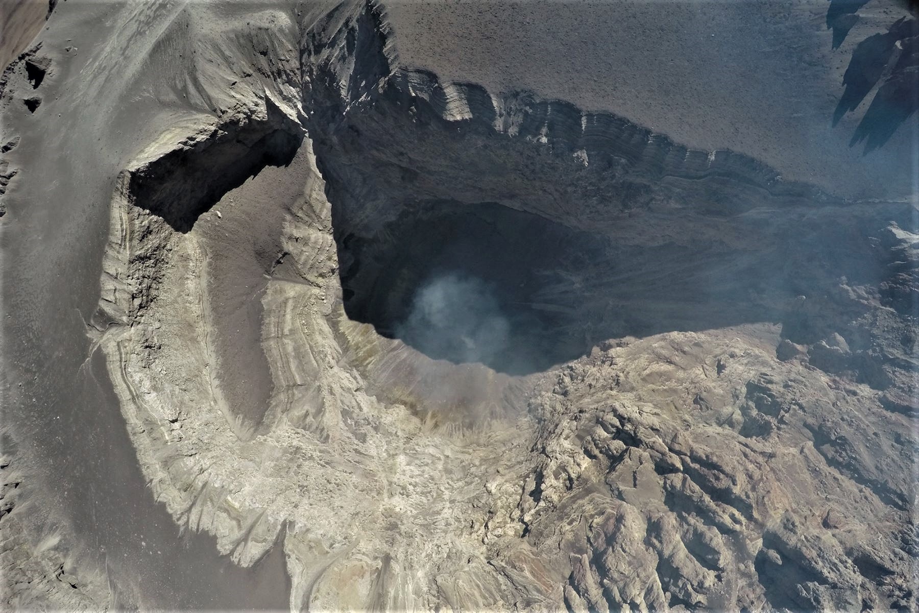
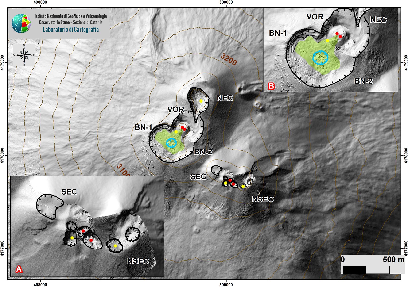
During the week, the monitoring of volcanic activity in the upper craters of Mount Etna was carried out by analyzing the images of the surveillance cameras of the INGV, Osservatorio Etneo (INGV-OE) and by observations made by INGV-OE staff. on 19, 22, 23 and 24 May. The figure shows the summit area of Mount Etna obtained from photogrammetric calculations of images taken with drones on May 9 by Mr. Cantarero and E. De Beni (INGV-OE) superimposed on the 2014 DEM created by Air-Physics Laboratory-Section Rome 2. The figure shows the details of the volcanic complex formed by the Southeast Crater and the New Southeast Crater (A), and by the Bocca Nuova and the Voragine (B). The indented black lines indicate the edge of the summit craters: BN = Bocca Nuova, with the Northwest (BN-1) and Southeast (BN-2) depressions; VOR = Voragine; NEC = Northeast Crater updated in July 2017; SEC = Southeast Crater; NSEC = New Southeast Crater. The indented blue line indicates the depression inside the Bocca Nuova. Yellow circles indicate degassing nozzles while red circles indicate active nozzles. The green polygon defines the cooling flow. Dashed lines indicate that the boundary is uncertain because the presence of gas slightly obliterated some areas during the surveys.
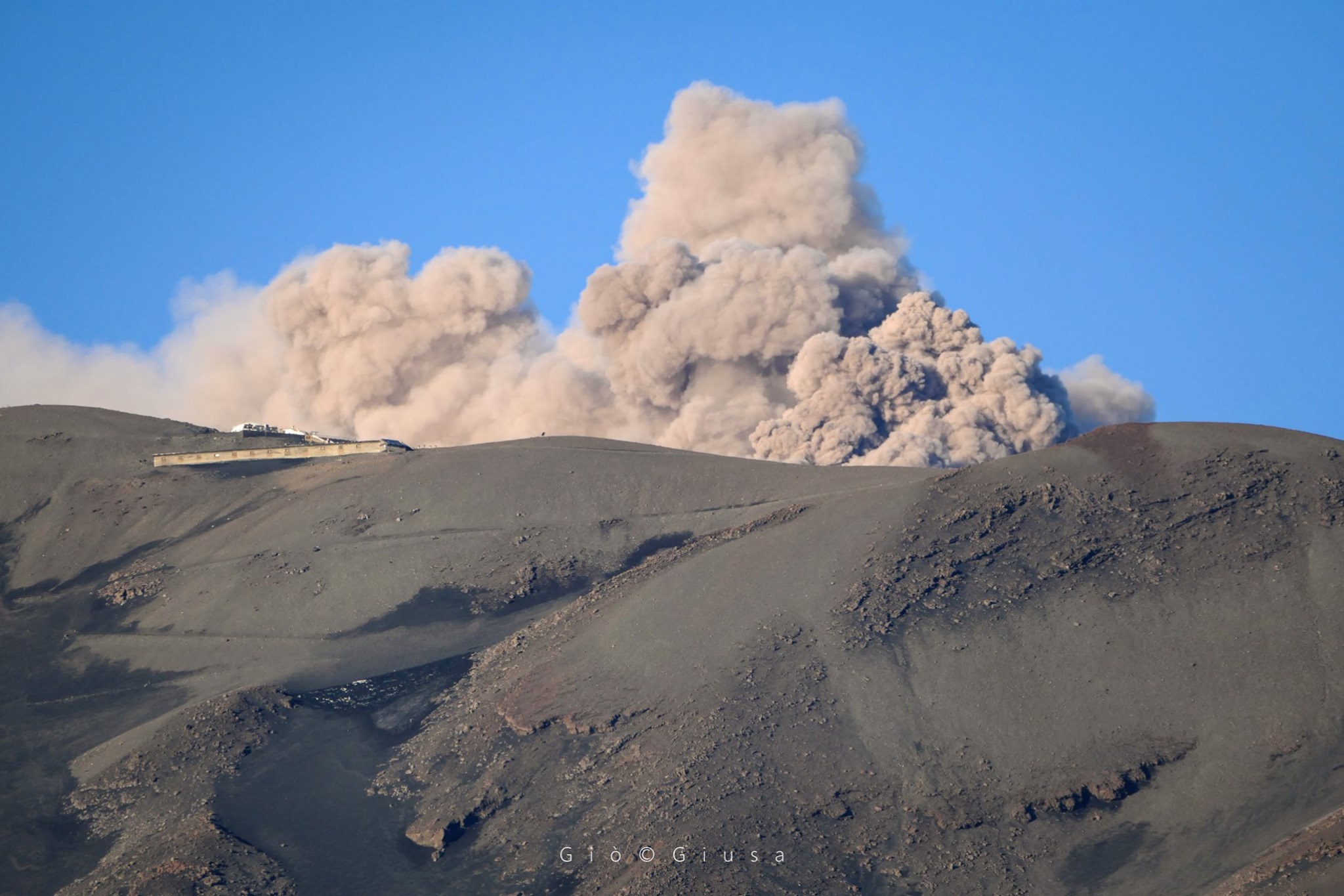
During the period considered, the upper craters were characterized by strombolian activity with sporadic volcanic ash emissions in the crater of Voragine (VOR), by strombolian activity with volcanic ash emissions and the formation of a eruptive cloud in the New Southeast Crater (NSEC) and degassing activities accompanied by roars in the Northeast crater (NEC).
Strombolian activity continues in the Voragine crater, described the previous week (Rep. N ° 21/2020), with sporadic volcanic ash emissions which are rapidly dispersed near the summit area. This activity was observed both by the analysis of the images of the INGV-OE video surveillance cameras and by direct observations made during the inspection on May 23 by INGV-OE staff. At the time of the inspection, activity was low and modest volcanic ash emissions were produced with a frequency between 10 and 20 minutes. In addition, the products of Strombolian activity rarely reached the edge of the crater. Compared to the inspection carried out in the summit area on May 15 (Rep. N ° 21/2020), a deposit of large clasts (even> 30 cm) was observed, associated with a more intense explosive activity, which covered the northeast flank of the cone which has developed since September 2019 in the Voragine crater; some large clasts were also present in correspondence with the zone which separates the crater of Voragine from the crater of the North-East. The clasts are largely smoking and covered with a thick white patina. In addition, during the inspection, a widening of the depression inside the lava field of the Bocca Nuova was observed.
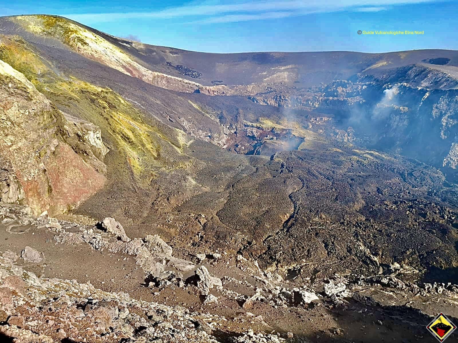
Photo taken from the west side of Bocca Nuova, the craterization process which affects the same crater is clearly visible, with the formation of a new well by collapse. Typical geological-structural phenomenon that evolves rapidly despite the continuous flows that have poured into the depression for almost 8 months.
From 18:29 UTC on May 18, the New South-East Crater (NSEC) was characterized by Strombolian activity produced in correspondence with the so-called « mouth of the saddle ». This activity, as observed from the analysis of the images coming from the INGV-OE’s video surveillance cameras, was very variable throughout the week and generally produced a low emission of volcanic ash, and loud roars heard by INGV-OE personnel present in the summit area on May 19 and 22. During the phases of maximum intensity, the explosive activity produced a volcanic cloud with a maximum height of 4.5 km, as observed by the images of the calibrated visible camera located in Bronte. In particular, on May 22, the explosive activity produced a volcanic cloud which directed towards the southern slope of the volcano forming a thin deposit of volcanic ash also observable in Catania. During the May 23 inspection, the NSEC showed only intense degassing and sporadic emissions of very diluted volcanic ash associated with intra-crater collapses. Finally, the northeast crater was characterized by low degassing activity. The INGV-OE staff, during the inspection on May 23, heard almost continuous roars without observing the emission of products associated with this activity.
Source : INGV.
Lire l’article en entier : file:///C:/Users/Utilisateur/AppData/Local/Packages/Microsoft.MicrosoftEdge_8wekyb3d8bbwe/TempState/Downloads/BollettinoEtna20200526%20(1).pdf
Photos : Gio Giusa , INGV , Guide Vulcanologiche Etna Nord / Domenico Domanti .
Colombia , Chiles / Cerro Negro :
Weekly activity bulletin of Chiles and Cerro Negro volcanoes
Volcanic activity continues at the YELLOW LEVEL ■ (III): CHANGES IN THE BEHAVIOR OF VOLCANIC ACTIVITY.
According to the monitoring of the activity of the CHILE VOLCANOES and CERRO NEGRO, the COLOMBIAN GEOLOGICAL SERVICE (SGC) reports that:
Compared to the previous week, in the period evaluated between 19 and 25 May 2020, at low levels, a decrease in the occurrence and an increase in the energy of the earthquakes were observed. It follows the predominance of earthquakes associated with rock fractures inside the volcano, which were localized in a dispersed manner, at distances between 0 and 14 km, with depths between 2 and 11 km, from the summit Chiles (4700 m) and with a maximum magnitude of 1.4 on the Richter scale.
The changes recorded by one of the volcanic deformation sensors have continued since May 2019. The other volcanic monitoring parameters did not show significant variations and no manifestation of surface activity was observed.
The COLOMBIAN GEOLOGICAL SERVICE and the GEOPHYSICAL INSTITUTE OF THE NATIONAL POLYTECHNIC SCHOOL OF ECUADOR continue to follow the evolution of the volcanic phenomenon, by timely signaling the observed changes. The occurrence of earthquakes with high energy levels that can be felt by the inhabitants of the area of volcanic influence is not excluded.
Source : SGC.
Photo : researchgate.
Guatemala , Fuego :
Type of activity: Vulcanian
Morphology: composite stratovolcano
Location: 14 ° 28’54˝ Latitude N; 90 ° 52’54˝ Longitude W.
Height: 3763 m above sea level.
Atmospheric conditions: Clear
Wind: North Est at 2 km / h.
Precipitation: 72.9 mm.
Activity:
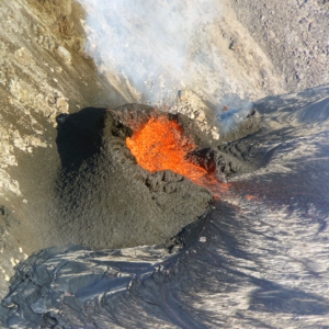
The Fuego Volcano Observatory reports weak white degassing smoke at an altitude of 4000 meters (13,123 feet) which remains above the crater. He reports 8 to 10 weak to moderate explosions per hour which eject ash columns at a height of 4400 to 4700 m above sea level (14435-15420 feet) which disperse in a west and northwest direction. Incandescent pulses up to 300 meters above the crater were observed at night and early in the morning, producing weak to moderate avalanches towards the Seca, Ceniza and Las Lajas ravines. The explosions generated weak to moderate rumblings which cause shock waves to vibrate the houses of the villages near the volcano on its southern flank. Locomotive noises are heard for periods of 1 to 2 minutes. The lava flow towards the Seca canyon remains active with a length of about 150 meters.
Source : Insivumeh.
Photo : 660citynews.com