
August 14 , 2022.
Italy , Stromboli :
In the early morning of August 12, and more precisely between 5:30 and 6:30 a.m., a violent downpour hit the island of Stromboli. As indicated by the weather station of Scari, managed by the INGV with the collaboration of the local association for social promotion « Attiva Stromboli », more than 60 millimeters of rain fell in one hour, and more than half of between them in just 15 minutes, between 5:45 a.m. and 6:00 a.m., as shown in the graph below.

To make a comparison that gives an idea of the intensity of this event, in just 15 minutes the same amount of rain fell as that which falls on Stromboli on average throughout the month of May. Heavy rains of this type, which in the past were classified as exceptional events, are becoming more and more common, which is due to the overheating of the ground and the atmosphere induced by the ongoing climate changes.
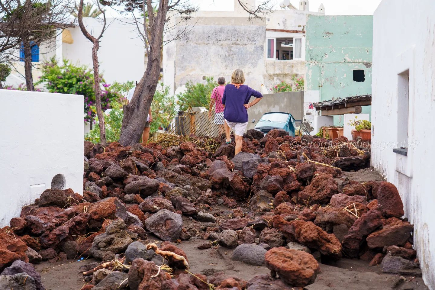
This intense rain set off a vast flow of mud and debris, which broke loose from the slopes above and invaded the city’s roads, homes and businesses, causing massive damage.
The disastrous flooding is the result of the combined effect of this intense rain with the total denudation of the ground which occurred following the forest fire of May 25, which completely destroyed the vegetation cover of the slopes at the above the city.
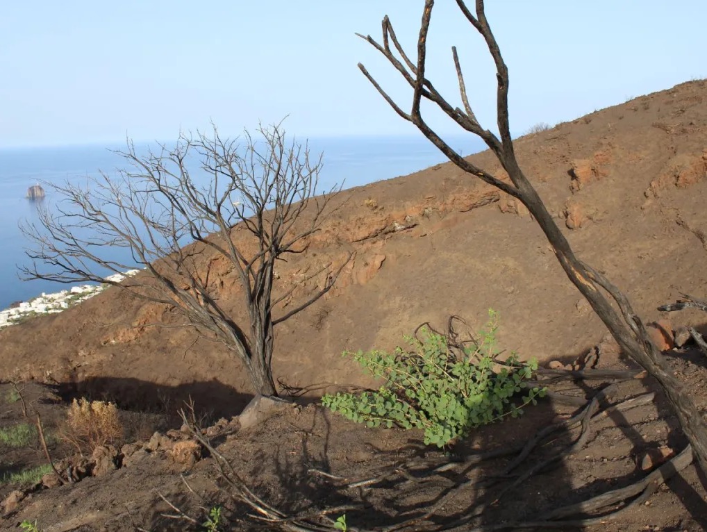
The Vallonazzo, the most important valley above the town of Stromboli (in the background), completely stripped of vegetation due to the forest fire of May 25.
The plant cover in fact acts as a buffer that preserves the soil from the direct action of rain, extending its stabilizing action into the immediate subsoil thanks to the roots, the interweaving of which creates a real network that helps to keep the soil together. different volcanic elements of which the soil of Stromboli is composed: even very fine ash, slag, pumice and rock fragments even of large dimensions.
Once the vegetation cover has disappeared as a result of the fire, the mechanical energy released by the impact of raindrops on bare ground tends to separate its tiniest components, such as volcanic ash, forming mudslides and debris flowing down slopes incorporate other, even coarser materials, gradually increasing their erosive capacity.
Intense rains and increasingly frequent forest fires due to climate change-induced overheating are among the main causes of hydrogeological instability. These phenomena are of particular importance in territorial areas which, by their intrinsic nature, are particularly exposed to instability, such as active volcanic areas, which confirms the need for appropriate and effective monitoring and protection of risky slopes.
Source : INGV Ambiente .
Read the article : https://ingvambiente.com/2022/08/12/lalluvione-di-stromboli-del-12-agosto-2022/
Photos : INGV , Stromboli Stati D’animo.
Indonesia , Merapi :
Report on the activity of Mount Merapi from August 5 to 11, 2022, August 12, 2022.
RESULTS OF OBSERVATIONS
Visual
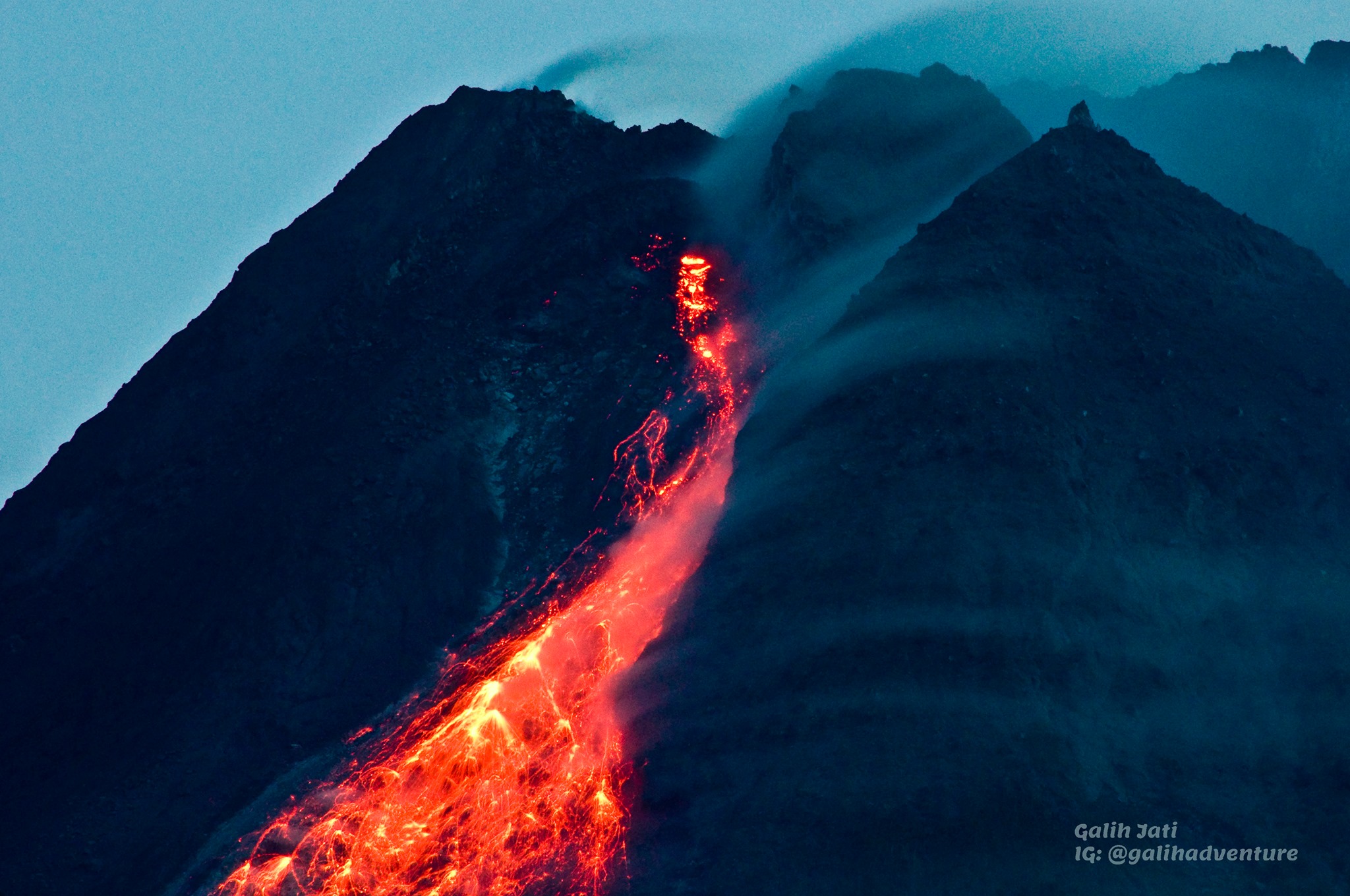
The weather around Mount Merapi is generally sunny in the morning and evening, while it is foggy in the afternoon. White smoke, thin to medium thickness, low pressure and 100 m high was observed from the Mount Merapi Babadan observation post on August 11, 2022 at 06:06 WIB.
This week, 43 lava avalanches were observed in the Southwest, descending the Bebeng River with a maximum slip distance of 1,500 m.
In the Southwest dome, the growth of the dome is observed, the volume of the dome is calculated at 1,664,000 m3. As for the central dome, it is 2,772,000 m3.
Seismicity
This week, the seismicity on Mount Merapi recorded:
13 shallow volcanic earthquakes (VTB),
582 multiple phase earthquakes (MP),
633 avalanche earthquakes (RF),
159 emission earthquakes (DG)
5 tectonic earthquakes (TT).
The intensity of this week’s earthquake is still quite high.
Deformation
Mount Merapi’s deformation that was monitored using EDM and GPS this week showed no significant changes.
Rain and lahars
This week, no rain was reported at the Mount Merapi observation post. There are no reports of lahars or additional flow in the rivers that originate on Mount Merapi.
Conclusion
Based on the results of visual and instrumental observations, it is concluded that:
Volcanic activity at Mount Merapi is still quite high in the form of effusive eruption activity. The state of the activity is defined at the « SIAGA » level.
Source : BPPTKG
Photo : Yohannes Tyas Galih Jati
La Réunion , Piton de la Fournaise :
Piton de la Fournaise activity
Seismicity
In July 2022, the OVPF-IPGP recorded at the level of the Piton de la Fournaise massif in total:
• 29 superficial volcano-tectonic earthquakes (0 to 2.5 km above sea level) under the summit craters;
• 2 deep earthquakes (below sea level);
• 1178 landslides (in the Cratère Dolomieu, the ramparts of the Enclos Fouqué and the Piton de Crac, and the Rivière de l’Est).
The month of July 2022 will have been marked by low seismicity at the level of Piton de la Fournaise with an average of 1 superficial volcano-tectonic earthquake per day.
Most of these events were located under the Dolomieu crater.

Shots of the broken River East on July 25, 2022 (© SAG-PGHM).
The month of July was also marked by many (1178) landslides (in the Cratère Dolomieu, the ramparts of the Enclos Fouqué and at the cassé of Rivière de l’Est . The majority of the collapses and the most important take place in the sector of the cassé of Rivière de l’Est. An aerial reconnaissance carried out by the Air Section of the Gendarmerie and the PGHM on July 25 shows the presence of a large scree cone at the foot of the cassé of Rivière de l’Est.
CO2 concentration in the ground:
Following the eruption of December 2020, a continuous increase in CO2 emissions from the ground is recorded at the level of the distal sites (Plaine des Cafres sectors) but also proximal (Gîte du volcan).
The last eruption took place from December 22, 2021 to January 17, 2022. From December 27, 2021, the eruption was associated with a rapid and unprecedented increase in CO2 emissions from the ground on the station proximal to the Gîte and with a trend reversal on the distal stations. The inversion observed at the distal stations lasted until January 7, 2022, then the concentrations remained stable at intermediate values until the end of January.
On the site proximal to the Gîte, a sudden drop in flux with very low CO2 values was detected after January 3, 2022. At the end of the eruption a new phase of increase was recorded, but with a higher rate. weak. The strong fluctuations observed during the month of February are certainly linked to environmental influences due to two cyclonic events. A further increase was recorded in both distal and near field at the end of February with a sharp acceleration in mid-March 2022. This phase of increase lasted until May 5 in the distal field and until May 19 in the near field.
It should be noted that the isotopic analysis of the gases sampled both in the distal field (PNRN, Plaine des Palmistes) and in the proximal field shows a marked increase in the magmatic contribution over the period March-April 2022.
Source : OVPF.
Lire l’article : https://www.ipgp.fr/sites/default/files/ovpf_20220801_bullmensu.pdf
Photos : © SAG-PGHM , G Vitton.
Etats- Unis , Yellowstone :
44°25’48 » N 110°40’12 » W,
Summit Elevation 9203 ft (2805 m)
Current Volcano Alert Level: NORMAL
Current Aviation Color Code: GREEN
Recent Work and News
Yellowstone Volcano Observatory scientists continued with a busy field schedule this summer. In July, additional semipermanent GPS stations were installed, bringing the total number of stations deployed to 17. These sensors, which provide seasonal densification of the existing continuous GPS network, will be removed in September/October, before the snow starts to accumulate, so that the data can be downloaded and analyzed.
Steamboat Geyser did not erupt during the month of July (the most recent eruption occurred on June 20). There have been 8 major water eruptions of the geyser in 2022.

Seismicity
During July 2022, the University of Utah Seismograph Stations, responsible for the operation and analysis of the Yellowstone Seismic Network, located 59 earthquakes in the Yellowstone National Park region. The largest event of the month was a minor earthquake of magnitude 3.1 located about 14 miles south-southwest of Mammoth Hot Springs in Yellowstone National Park on July 30 at 1:44 AM MDT. The event was part of a small swarm of 13 earthquakes that occurred during July 29–30.
Earthquake sequences like these are common and account for roughly 50% of the total seismicity in the Yellowstone region.
Yellowstone earthquake activity remains at background levels.
Ground deformation
Conitinuous GPS stations in Yellowstone Caldera and near Norris Geyser Basin recorded a few millimeters of uplift (less than half an inch) since the start of summer. This deformation is a result of snowmelt that percolates into the ground and causes the surface to swell slightly, like a sponge. The same summer-only signal is detected annually and is superimposed on the overall trend of caldera subsidence, which has been ongoing since 2015 at a rate of a few centimeters (1–2 inches) per year.
Source : YVO.
Photo : Mammoth Hot Springs ,Brocken Inaglory.
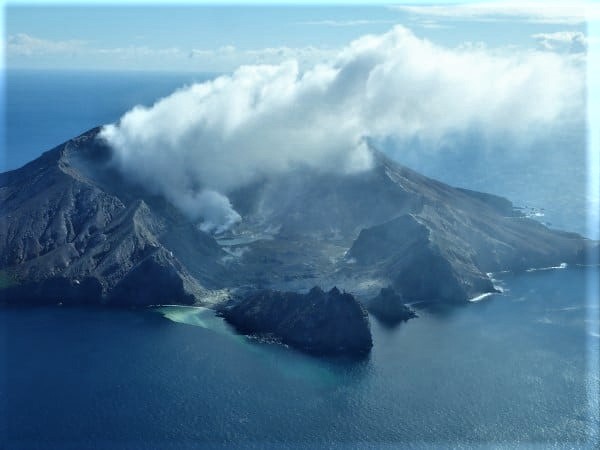
New Zealand , White Island :
Whakaari/White Island: Loss of near real-time monitoring. Minor volcanic unrest continues. Published: Wed Aug 10 2022 2:00 PM
Near real-time monitoring of Whakaari has been lost with the failure of the last surviving seismometer and pressure sensor on the island. We continue to monitor via other, less-frequent methods. The Volcanic Alert Level for Whakaari/White Island remains at Level 1. The Aviation Colour Code also remains at Green.
The monitoring network at Whakaari consisted of two sites with earthquake and pressure sensors (to detect explosive airwaves), three cameras, two SO2 (sulphur dioxide) gas scanners and two GNSS antenna for measuring ground deformation. Since the 9 December 2019 eruption, the on-island network has not been serviced and power supplies, sensors and cameras have degraded or failed over time. Our near real-time capability has been largely reliant on the on-island earthquake and pressure sensors. The first of these failed in April 2021 and the second failed late last week.
The loss of the second earthquake and pressure sensor reduces our ability to closely monitor the volcano in near real-time. Until we are able to service our on-island equipment and power supplies, we will be increasing the frequency of our gas and observation flights to the island.
Our most recent gas observation flight occurred two weeks ago, and the results indicated the level of activity at the island had remained low, with normal fumarole and gas emissions. Since that flight, the seismicity had remained low, and no deformation signals had been recorded. These observations are consistent with low levels of volcanic unrest. The Volcanic Alert Level remains at Level 1 and the Aviation Colour Code remains Green.
Source : Geonet / Geoff Kilgour / Duty Volcanologist.
Photo : Geonet.
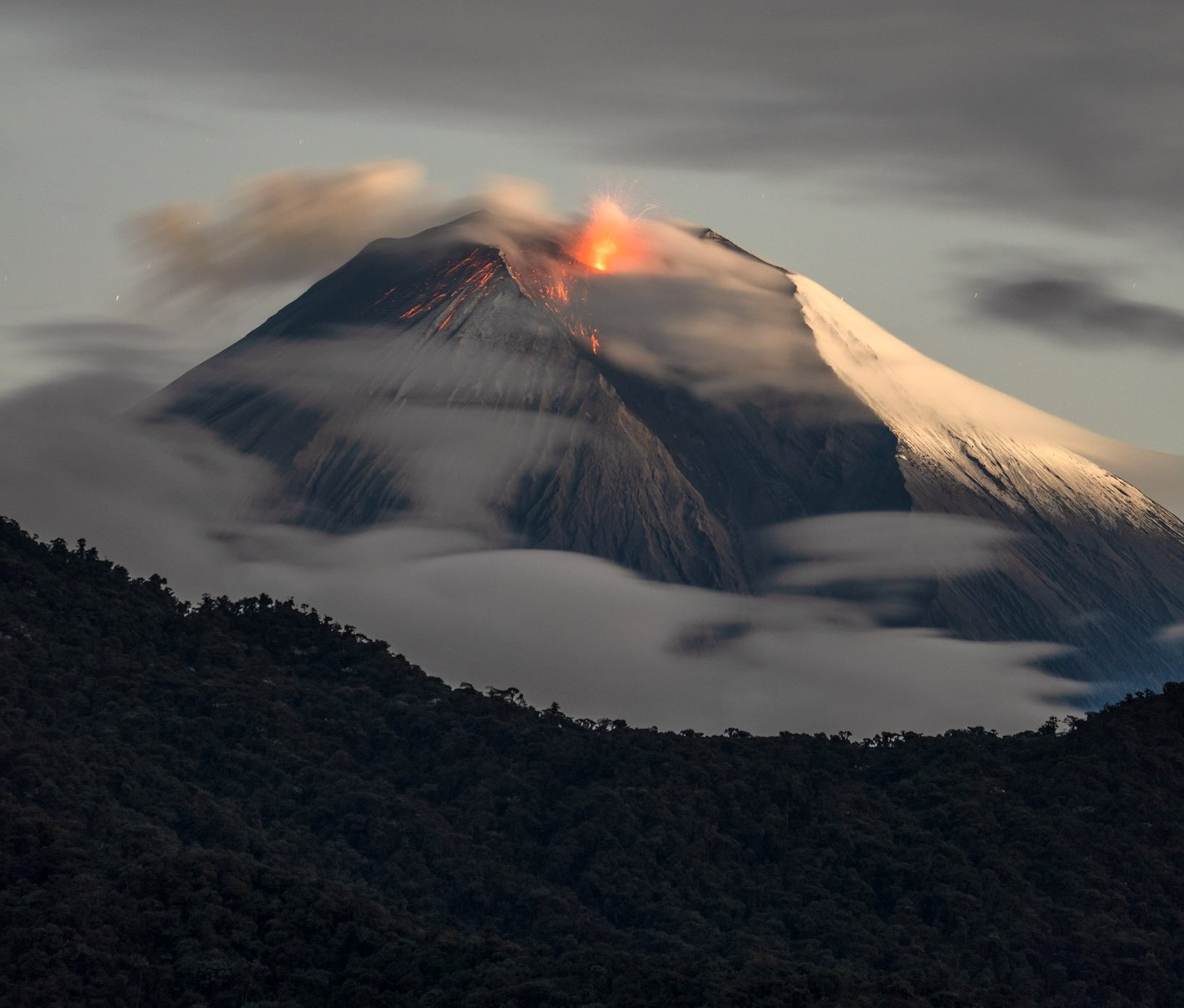
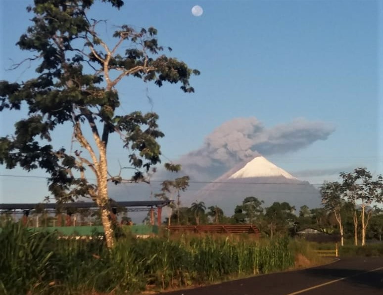
Ecuador , Sangay :
DAILY REPORT OF THE STATE OF SANGAY VOLCANO, Saturday August 13, 2022.
Information Geophysical Institute – EPN.
Surface activity level: High, Surface trend: Ascending.
Internal activity level: High, Internal trend: No change.
Seismicity: From August 12, 2022, 11:00 a.m. to August 13, 2022, 11:00 a.m.:
Explosion (EXP) 468
Long Periods (LP) 71
Emission Tremors (TREMI ) 83
Rains / Lahars: There are no reports of lahars. The weather conditions have been very good for the past 24 hours.
Emission / ash column:
With the increase in surface activity recorded since yesterday, continuous emissions of ash at low altitude (<2km above the crater) have been observed. The ash cloud extends west and southwest, crossing the provinces of Chimborazo, Bolívar, Cañar, Azuay and Guayas. So far, ashfall has been reported in the provinces of Chimborazo (Cebadas, Palmira, Chunchi and Alausi) and Guayas (Guayaquil, Milagro and Samborondón). At the moment, the cloud is low (< 2 km) and continuous and, due to good weather conditions, it could continue to cause light to moderate ash fall in the aforementioned provinces.
Other Monitoring Parameters:
The FIRMS system records 57 thermal alerts over the past 24 hours. The MIROVA system records 1 very high (4051 MW), 1 high (764 MW) and 1 low thermal alert during the last 24 hours.
Gas:
The Mounts system reports 992.1 tons of SO2, with data on 2022-08-12 at 1:52 p.m. TL.
Observation:
Yesterday, there was an increase in the internal and superficial activity of the Sangay volcano, with the increase in seismic energy, the emission of a new lava flow was highlighted on the southeast flank , the same one that can be seen on the images shared by the ECU-911 and the satellites. Due to the good weather conditions, the sounds coming from the volcano were heard in various sectors of the province of Guayas and it was possible to see the incandescence from the city of Macas. In addition, due to good weather conditions, several videos of commercial flights and photographs show the trajectory of the ash cloud towards the West.
Alert level: Orange.
Information, Saturday, August 13, 2022, Updated 1:30 p.m. TL.
The ash cloud from the Sangay volcano extends to the province of Guayas. This emission has already caused ash falls in the province of Chimborazo and Guayas yesterday and today in the province of Chimborazo (Alausí). For the moment, the cloud is diffuse and could cause a slight ash fall in Guayaquil. With the right weather conditions, this low-altitude emission managed to travel more than 200 km to the west and southwest of the volcano. This phenomenon has been recurrent during the current eruptive period which began in May 2019.
The IG-EPN continues to monitor the event and will inform in a timely manner if any changes in the monitoring signals are detected.
Source : IGEPN
Photos : Robinsky , Volcan Sangay FB.


No comment yet, add your voice below!