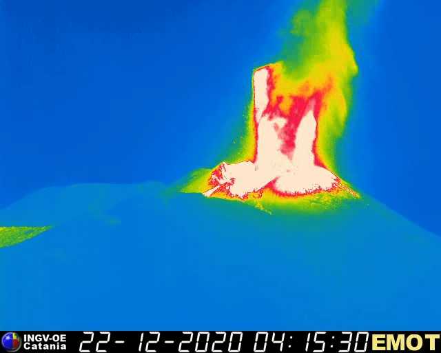
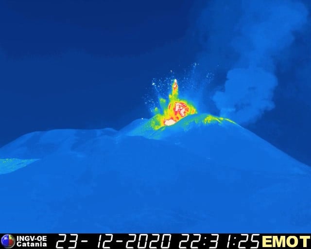
December 31, 2020. EN . Italy : Stromboli , Hawaii : Kilauea , Saint Vincent and the Grenadines : Soufrière Saint Vincent , Japan : Shinmoedake .

December 31 , 2020.


Italy , Stromboli :

Weekly Bulletin December 21, 2020 to December 27, 2020 (issue date December 29, 2020)

SUMMARY OF THE ACTIVITY BULLETIN

In the light of surveillance data, it is highlighted:
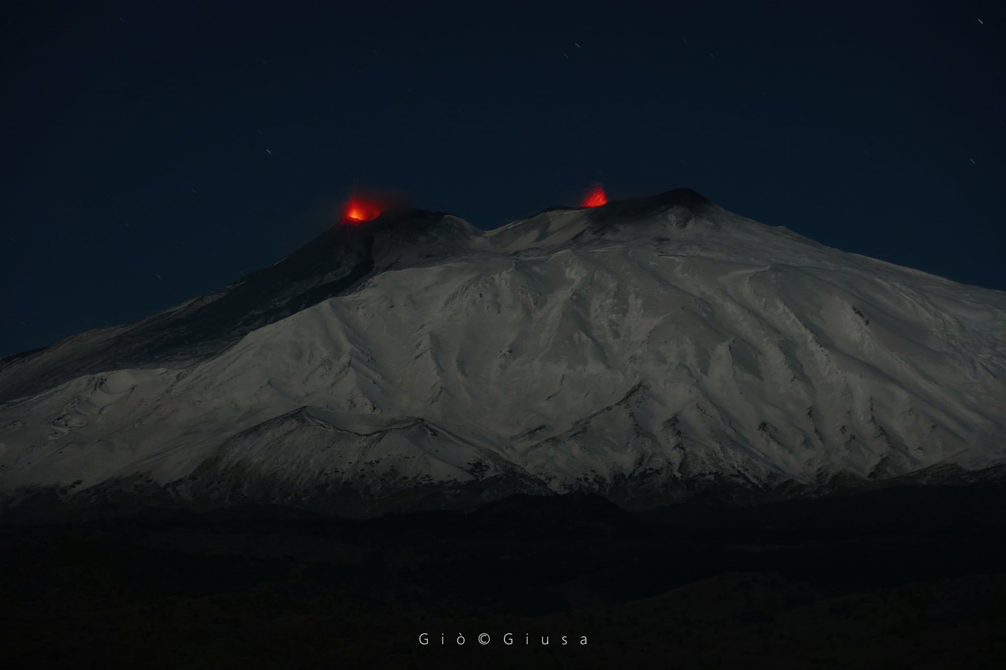
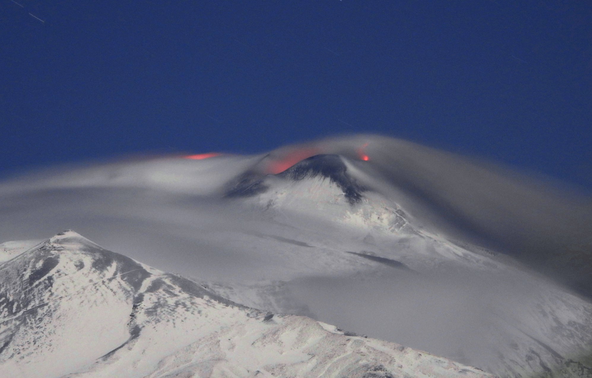
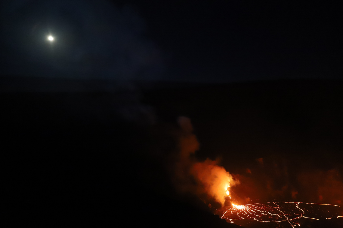
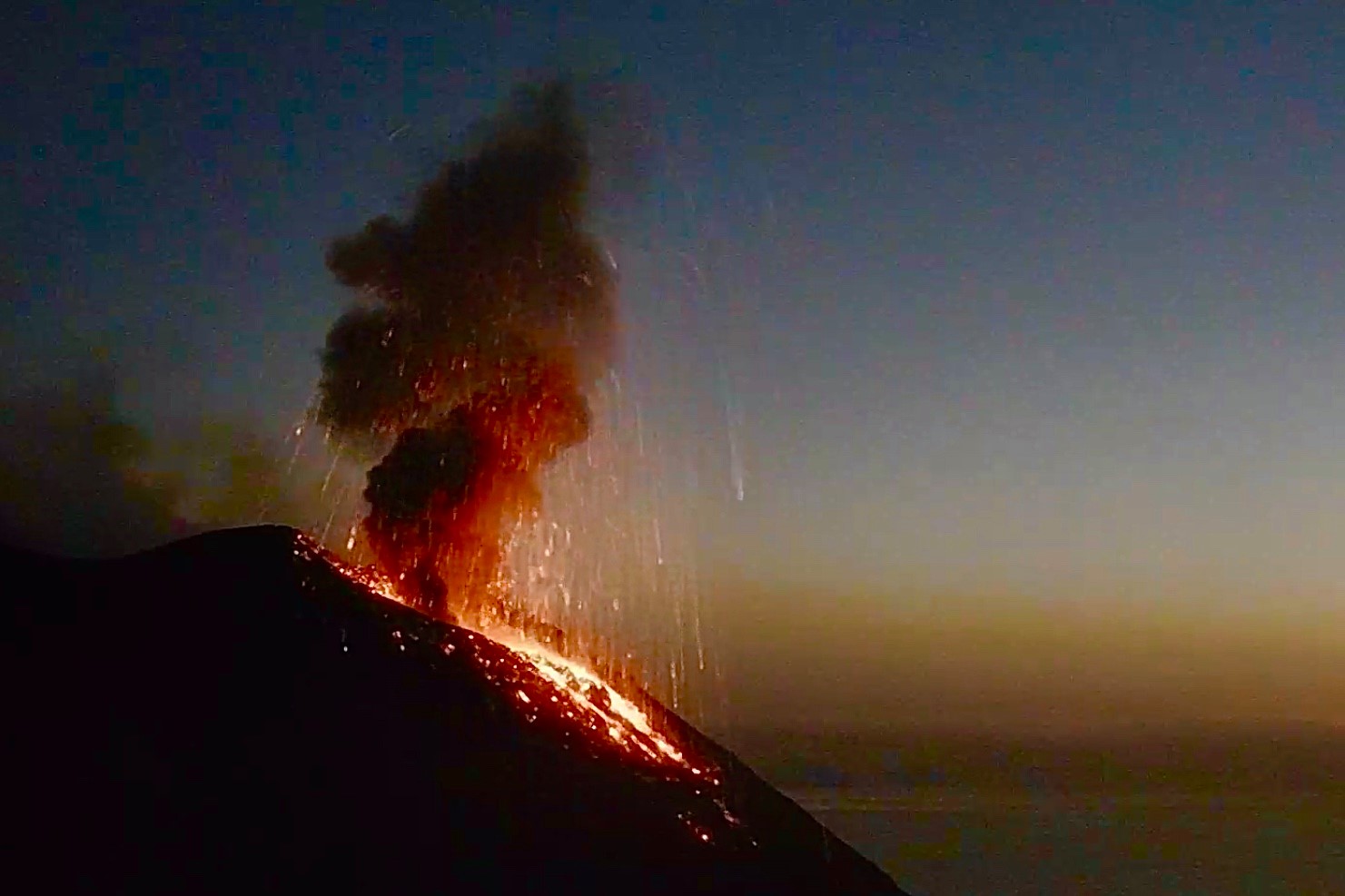
1) VOLCANOLOGICAL OBSERVATIONS: Explosive volcanic activity of Strombolian type at low level (4 to 3 events / h) and with a low intensity of explosions in the areas of the North and Center-South crater
2) SEISMOLOGY: The seismological parameters do not show significant variations.
3) DEFORMATIONS: No significant change recorded by tilt and GNSS networks
4) GEOCHEMISTRY: SO2 flux: medium level
C / S Ratio – There is no updated data: the latest values ​​available (6-12-2020) are on average levels (C / S = 12.1).
The isotopic ratio of Helium is at high values ​​(R / Ra = 4.4, sampling of December 21).
5) SATELLITE OBSERVATIONS: The thermal activity in the summit area is at a low level.

VOLCANOLOGICAL OBSERVATIONS

In the period under observation, the eruptive activity of Stromboli was characterized by the analysis of the images recorded by the surveillance cameras INGV-OE located at 190 m, Punta Corvi and 400 m.
In the area of ​​the North crater, the N1 and N2 craters, both characterized by two emission points, produced low intensity explosions (less than 80 m high) emitting fine material (ash) mixed with coarse material (lapilli and bombs). The average frequency of explosions varied between 1/2 and 2/5 events / h. In the Center-South zone, the explosions emitted mainly fine materials, with a low intensity and with a frequency between 1 and 3 to 6 events / h.
Overall, the total average frequency of explosions during the week was 4.3 events / hr, ranging from a low to a maximum of 2.0 and 5.3 events / h, respectively.

The amplitude of the volcanic tremor showed generally low values ​​on December 20, 21 and 22, then it reached medium-low values.

Source : INGV.

Read the article : http://www.ct.ingv.it/index.php/monitoraggio-e-sorveglianza/prodotti-del-monitoraggio/bollettini-settimanali-multidisciplinari/404-bollettino-settimanale-sul-monitoraggio-vulcanico-geochimico-e-sismico-del-vulcano-Stromboli20201229/file

Photo : Webcam


Hawaii , Kilauea :

19°25’16 » N 155°17’13 » W,
Summit Elevation 4091 ft (1247 m)
Current Volcano Alert Level: WATCH
Current Aviation Color Code: ORANGE

Activity Summary:
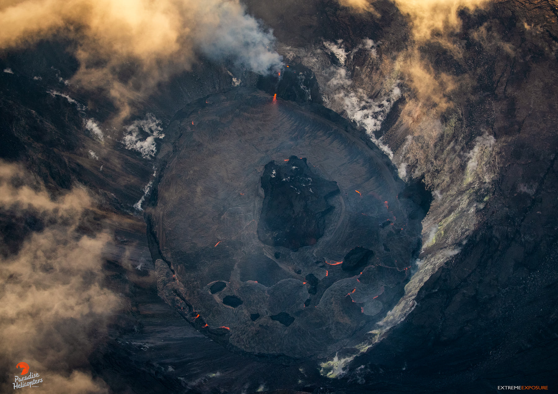
Lava activity is confined to Halemaʻumaʻu with lava erupting from vents on the northwest side of the crater. As of 3:45 am this morning (Dec. 30), the lava lake was 181 m (593 ft) deep with a narrow black ledge around it. Reduced, but still elevated, SO2 emissions were measured Monday (Dec. 28).

Overnight, the eruption in Halema‘uma‘u at Kīlauea’s summit continued. At about 3:45 a.m. HST this morning (Dec. 30), HVO field crews measured the lava lake as 181 m (593 ft) deep with a narrow black ledge around it. This photo, taken at around 2 a.m. HST December 30, shows that lava continues to flow from the west vents into the lava lake. Reduced, but still elevated, SO2 emissions were measured at Kīlauea’s summit on Monday (Dec. 28), with rates of about 3,300 tonnes/day.

Summit Observations:
Preliminary analysis of sulfur dioxide emission rates measured Monday (Dec. 28) show that the rates are about 3,300 tonnes/day– slightly lower than the Dec. 27 rate of 5,500 t/d, but still elevated; both values were in the range of emission rates common for the pre-2018 lava lake. Summit tiltmeters continued to record weak inflationary tilt starting on Monday (Dec. 26). Seismicity remained elevated but stable, with steady elevated tremor and a few minor earthquakes.

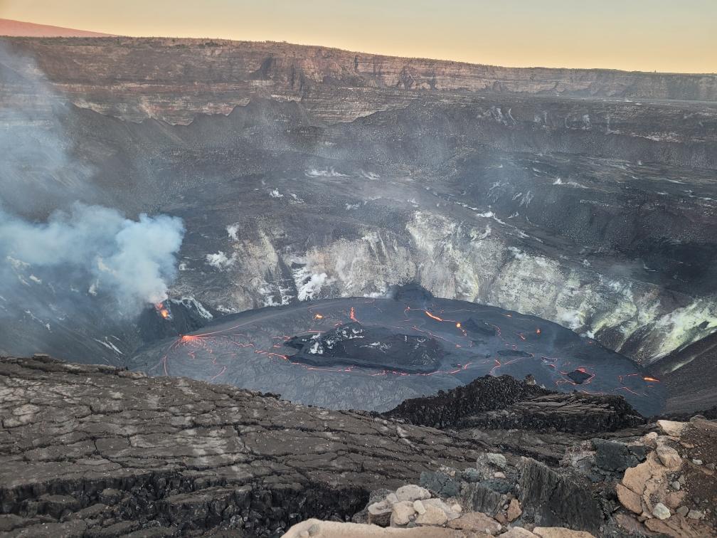
The lava lake within Halemaʻumaʻu crater has changed little in the past few days.The most recent thermal map (Dec. 28) provided the lake dimensions as 770 by 490 m (840 by 535 yds) for a total area of 29 ha (72 acres). Over the past day, the main island of cooler, solidified lava floating in the lava lake (the raised mass visible in the center of the photo) drifted slightly to the west (left in the photo) in the lake and rotated counter-clockwise, whereas the 10 or so much smaller islands to the east (raised masses to the right of the island in the photo) remained stationary. The main island measured about 250 m (820 ft) in length, 135 m (440 ft) in width, and about 3 ha (7 acres) in area based on the Dec. 28 thermal map. Measurements on Dec. 27 show that the island surface was about 6 m (20 ft) above the lake surface.

East Rift Zone Observations:
Geodetic monitors indicate that the upper portion of the East Rift Zone (between the summit and Puʻu ʻŌʻō) contracted while the summit deflated. There is no seismic or deformation data to indicate that magma is moving into either of Kīlauea’s rift zones.

Halemaʻumaʻu lava lake Observations:
The west vents spattered while erupting lava flowed through crusted-over channels into a lava lake within Halemaʻumaʻu crater.

The lava lake within Halemaʻumaʻu crater has changed little in the past few days and was about 181 m (593 ft) deep as of early this morning (Dec. 30). The lake volume was about 23 million cubic meters (30 million cubic yards or 5.2 billion gallons). The most recent thermal map (Dec. 28) provided the lake dimensions as 770 by 490 m (840 by 535 yds) for a total area of 29 ha (72 acres). The narrow (10-30 m or 11-22 yd) ledge around the lake was about 1-2 m (1-2 yds) above the active lake surface

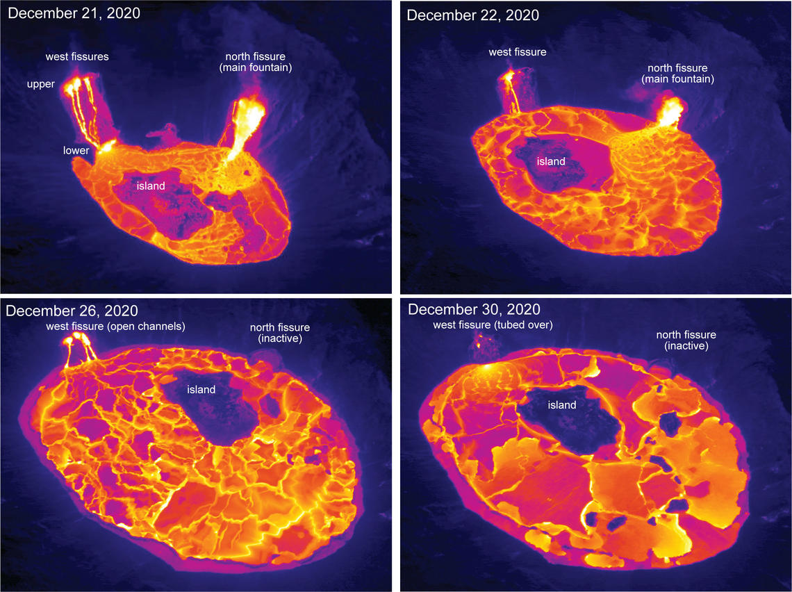
These aerial thermal images of Kīlauea Volcano’s summit compare the changes within Halema‘uma‘u crater over the course of this summit eruption. The first image (upper left) was taken on December 21, the morning after the eruption started, with the north and west fissure vents feeding the lava lake and the middle fissure inactive. The depth of the lava lake was approximately 88 m (289 ft). By the next morning, December 22, (upper right) the lava lake depth increased to about 134 m (440 ft) and had drowned the inactive middle fissure. In the December 26 image (lower left), the north fissure is inactive and only the west fissure vents are feeding lava into the lava lake, which was at a depth of about 176 m (577 ft) that morning. During today’s overflight (lower right), the lava lake was approximately 182 m (597 ft) deep, and lava flowing into the lake was crusted over. Note the change in position over time of the island within the lava lake.

Over the past day, the main island of cooler, solidified lava floating in the lava lake drifted slightly to the west in the lake and rotated counter-clockwise. The 10 or so much smaller islands to the east remained stationary. The main island measured about 250 m (820 ft) in length, 135 m (440 ft) in width, and about 3 ha (7 acres) in area based on the Dec. 28 thermal map. Measurements on Dec. 27 show that the island surface was about 6 m (20 ft) above the lake surface.

Source : HVO

Photos : USGS photo by H. Dietterich. USGS photo by N. Deligne. , M. Patrick.


Saint-Vincent-and-the-Grenadines , Soufrière Saint Vincent :

LA SOUFRIERE BULLETIN, DECEMBER 30, 2020 6.00 PM

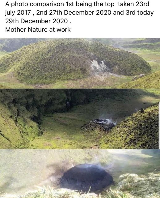
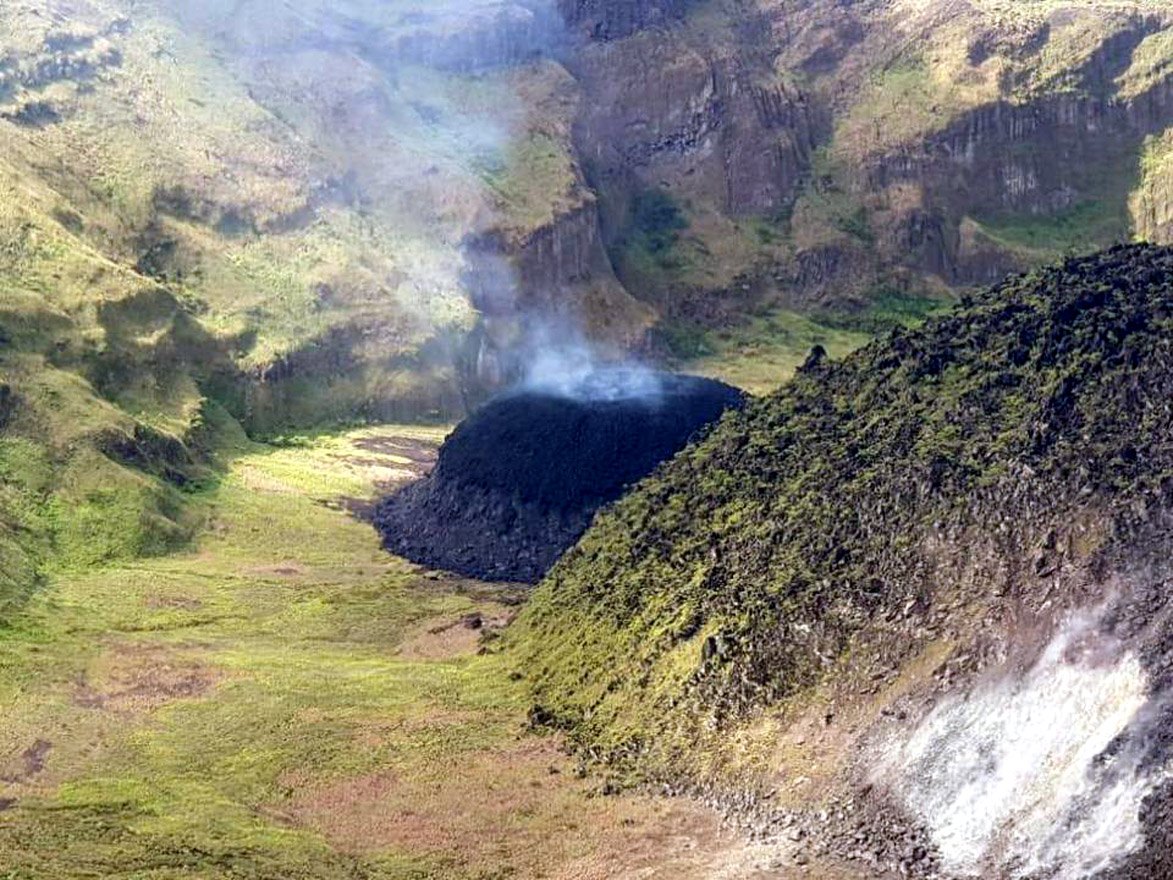
An Aerial reconnaissance conducted today Wednesday, December 30 indicates that there are no significant changes at the La Soufriere Volcano since Tuesday, December 29th, 2020. Magma continues to ooze to the surface and the dome has increased in size.


The Executive Committee of the National Emergency Management Organisation (NEMO), which comprises Technical Officers from the various
Government Departments, Private Sector and Non- Governmental Organizations met today at NEMO’s Conference Room to activate plans, in the event that the level of seismicity increases and evacuation becomes necessary.
The Caribbean Disaster Emergency Management Agency (CDEMA) has activated the Regional Coordination Plan as per the protocol which corresponds to the Orange Volcano Hazard Alert Level.

A group of Scientists from the Seismic Research Centre, University of the West Indies St. Augustine Campus led by Vincentian Professor Richard Robertson will arrive in St. Vincent and the Grenadines on Thursday 31st December, 2020 on board the Regional Security System (RSS) Aircraft. The Scientists will install instruments to strengthen the monitoring mechanism System, so that more accurate and timelier scientific advisory on the activities at the La Soufriere Volcano can be provided.
Alert level remains at Orange. Persons living in areas close to the volcano which include communities from Fancy to Georgetown and Belle Isle to Richmond are asked to remain alert and listen to all advisories from the National Emergency Management Organisation (NEMO).
The National Emergency Management Organisation is once again reminding the public that no evacuation order or notice has been given.
NEMO is also appealing to the public to desist from visiting the La Soufriere Volcano until the scientists advise that it is safe to do so.

The University of the West Indies Seismic Research Centre (UWI-SRC) stated in a press briefing that seismicity at the volcano began to increase in early November and changes in the water lake and fumarolic area were noted on 16 December. A persistent thermal anomaly had been identified in satellite data over the previous couple of days, which is what prompted the NEMO field visit.

Source : NEMO. GVP.
 
Photo :David Wyndoze , Nemo .


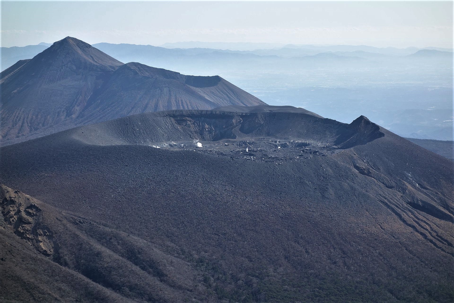
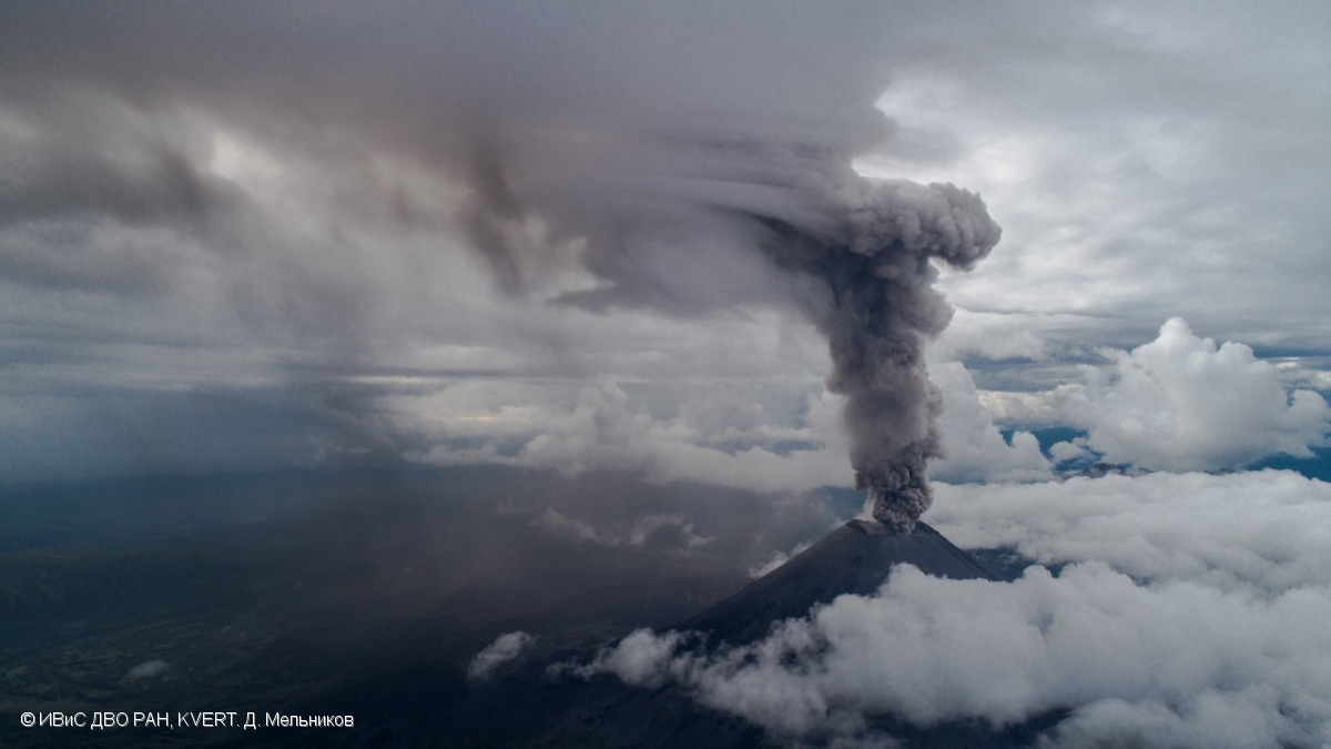
Japan , Shinmoedake :

JMA reported that the number of volcanic earthquakes at Shinmoedake (Shinmoe peak, a stratovolcano of the Kirishimayama volcano group) began to increase on 18 December and remained elevated. A total of 300 earthquakes were located beneath the summit crater during 16-25 December. No changes were detected in deformation and emission data. The Alert Level was raised to 2 (on a scale of 1-5) on 25 December, and the public was warned to exercise caution within a 2-km radius of the crater.
 
 
Kirishimayama is a large group of more than 20 Quaternary volcanoes located north of Kagoshima Bay. The late-Pleistocene to Holocene dominantly andesitic group consists of stratovolcanoes, pyroclastic cones, maars, and underlying shield volcanoes located over an area of 20 x 30 km. The larger stratovolcanoes are scattered throughout the field, with the centrally located Karakunidake being the highest. Onamiike and Miike, the two largest maars, are located SW of Karakunidake and at its far eastern end, respectively. Holocene eruptions have been concentrated along an E-W line of vents from Miike to Ohachi, and at Shinmoedake to the NE. Frequent small-to-moderate explosive eruptions have been recorded since the 8th century.
 
Source : GVP , JMA.
 
Photo : Wikipedia.


31 Décembre 2020. FR . Italie : Stromboli , Hawaii : Kilauea , Saint-Vincent-et-les-Grenadines : Soufrière Saint Vincent , Japon : Shinmoedake .

31 Décembre 2020.


Italie , Stromboli :

Bulletin hebdomadaire 21 Décembre 2020 au 27 Décembre 2020. (date d’émission 29 Décembre 2020)

SOMMAIRE DU BULLETIN D’ACTIVITÉ

À la lumière des données de surveillance, il est mis en évidence:
1) OBSERVATIONS VOLCANOLOGIQUES: Activité volcanique explosive de type strombolienne à faible niveau (4 à 3 événements / h) et avec une faible intensité d’explosions dans les zones du cratère Nord et Centre-Sud
2) SISMOLOGIE: Les paramètres sismologiques ne montrent pas de variations significatives.
3) DEFORMATIONS: Aucun changement significatif enregistré par les réseaux d’inclinaison et GNSS
4) GÉOCHIMIE: Flux SO2: niveau moyen
Rapport C / S – Il n’y a pas de données mises à jour: les dernières valeurs disponibles (6-12-2020) sont sur des niveaux moyens (C / S = 12,1).
Le rapport isotopique de l’Hélium se situe à des valeurs élevées (R / Ra = 4,4 , échantillonnage du 21 décembre).
5) OBSERVATIONS SATELLITES: L’activité thermique dans la zone du sommet est à un niveau bas.

OBSERVATIONS VOLCANOLOGIQUES

Dans la période sous observation, l’activité éruptive de Stromboli a été caractérisée par l’analyse des images enregistrées par les caméras de surveillance INGV-OE situées à 190 m, Punta Corvi et 400 m.
Dans la zone du cratère Nord, les cratères N1 et N2, tous deux caractérisés par deux points d’émission, ont produit des explosions de faible intensité (moins de 80 m de haut) émettant des matériaux fins (cendres) mélangé avec des matériaux grossiers (lapilli et bombes). La fréquence moyenne des explosions variait entre 1 / 2 et 2 / 5 événements / h. Dans la zone Centre-Sud, les explosions émettaient principalement de matériaux fins , avec une faible intensité et avec une fréquence comprise entre 1 et 3 à 6 événements / h.
Dans l’ensemble, la fréquence moyenne totale des explosions au cours de la semaine était de 4,3 événements / h, allant d’un minimum à un maximum de 2,0 et 5,3 événements / h, respectivement.

L’amplitude du tremor volcanique a montré des valeurs généralement faibles les 20, 21 et 22 Décembre, puis elle a atteint des valeurs moyennes-basses.

Source : INGV.

Lire l’articlehttp://www.ct.ingv.it/index.php/monitoraggio-e-sorveglianza/prodotti-del-monitoraggio/bollettini-settimanali-multidisciplinari/404-bollettino-settimanale-sul-monitoraggio-vulcanico-geochimico-e-sismico-del-vulcano-Stromboli20201229/file

Photo : Webcam


Hawaii , Kilauea :

19 ° 25’16 « N 155 ° 17’13 » W,
Altitude du sommet : 4091 pi (1247 m)
Niveau d’alerte volcanique actuel: WATCH
Code couleur de l’aviation actuel: ORANGE.

Résumé de l’activité:
L’activité de lave est confinée au cratère Halema’uma’u avec émission de lave depuis des évents sur le côté Nord-Ouest du cratère. À 3 h 45 ce matin (30 décembre), le lac de lave avait une profondeur de 181 m (593 pi) avec un étroit rebord noir autour de lui. Des émissions de SO2 réduites, mais toujours élevées, ont été mesurées lundi (28 décembre).

L’éruption de l’Halema’uma’u au sommet du Kīlauea s’est poursuivie. Vers 3 h 45 HST ce matin (30 décembre), les équipes de terrain du HVO ont mesuré le lac de lave à une profondeur de 181 m (593 pi) avec un étroit rebord noir autour de lui. Cette photo, prise vers 2 heures du matin HST le 30 décembre, montre que la lave continue de couler des évents Ouest dans le lac de lave. Des émissions de SO2 réduites, mais toujours élevées, ont été mesurées lors du sommet du Kīlauea, lundi 28 décembre, avec des taux d’environ 3300 tonnes / jour.

Observations du sommet:
L’analyse préliminaire des taux d’émission de dioxyde de soufre mesurés lundi (28 décembre) montre que les taux sont d’environ 3 300 tonnes / jour – légèrement inférieurs au taux du 27 décembre de 5 500 t / j, mais toujours élevés; les deux valeurs se situaient dans la gamme des taux d’émission communs pour le lac de lave d’avant 2018. Les inclinomètres du sommet ont continué d’enregistrer une faible inclinaison inflationniste à partir de lundi (26 décembre). La sismicité est restée élevée mais stable, avec un tremor constant et quelques tremblements de terre mineurs.

Le lac de lave dans le cratère Halema’uma’u a peu changé ces derniers jours. La carte thermique la plus récente (28 décembre) a fourni les dimensions du lac de 770 par 490 m (840 par 535 yds) pour une superficie totale de 29 ha (72 acres).  Au cours de la dernière journée, l’île principale de lave plus fraîche et solidifiée flottant dans le lac de lave (la masse surélevée visible au centre de la photo) a légèrement dérivé vers l’Ouest (à gauche sur la photo) dans le lac et a tourné dans le sens antihoraire, tandis que la dizaine d’îles beaucoup plus petites à l’Est (masses surélevées à droite de l’île sur la photo) sont restées stationnaires. L’île principale mesurait environ 250 m (820 pi) de longueur, 135 m (440 pi) de largeur et environ 3 ha (7 acres) de superficie selon la carte thermique du 28 décembre. Les mesures le 27 décembre montrent que la surface de l’île était à environ 6 m (20 pi) au-dessus de la surface du lac.

Observations sur la zone du Rift Est:
Les moniteurs géodésiques indiquent que la partie supérieure de la zone du Rift Est (entre le sommet et Puʻu ʻŌʻō) s’est contractée pendant que le sommet se dégonflait. Il n’existe pas de données sismiques ou de déformation pour indiquer que le magma se déplace dans l’une ou l’autre des zones de rift du Kīlauea.

Observations du lac de lave de Halema’uma’u:
Les évents Ouest ont éclaboussé tandis que la lave coulait à travers des canaux encroûtés dans le lac de lave du cratère Halema’uma’u.

Le lac de lave dans le cratère Halema’uma’u a peu changé au cours des derniers jours et était d’environ 181 m (593 pieds) de profondeur tôt ce matin (30 décembre). Le volume du lac était d’environ 23 millions de mètres cubes (30 millions de yards cubes ou 5,2 milliards de gallons). La carte thermique la plus récente (28 décembre) indiquait que les dimensions du lac étaient de 770 sur 490 m (840 sur 535 yds) pour une superficie totale de 29 ha (72 acres). Le rebord étroit (10-30 m ou 11-22 yd) autour du lac était à environ 1 à 2 m (1 à 2 yds) au-dessus de la surface active du lac

Ces images thermiques aériennes du sommet du volcan Kīlauea comparent les changements dans le cratère Halema’uma’u au cours de cette éruption au sommet. La première image (en haut à gauche) a été prise le 21 décembre, le matin après le début de l’éruption, les évents de fissure Nord et Ouest alimentant le lac de lave et la fissure médiane inactive. La profondeur du lac de lave était d’environ 88 m (289 pi). Le lendemain matin, le 22 décembre (en haut à droite), la profondeur du lac de lave a augmenté à environ 134 m (440 pieds) et a noyé la fissure intermédiaire inactive. Dans l’image du 26 décembre (en bas à gauche), la fissure Nord est inactive et seuls les évents de la fissure Ouest alimentent la lave dans le lac de lave, qui se trouvait à une profondeur d’environ 176 m ce matin-là. Au cours du survol d’aujourd’hui (en bas à droite), le lac de lave avait une profondeur d’environ 182 m (597 pi) et la lave coulant dans le lac était recouverte de croûtes. Notez le changement de position au fil du temps de l’île dans le lac de lave.

Au cours de la dernière journée, l’île principale de lave plus fraîche et solidifiée flottant dans le lac de lave a dérivé légèrement vers l’Ouest dans le lac et a tourné dans le sens inverse des aiguilles d’une montre. La dizaine d’îles beaucoup plus petites à l’est sont restées stationnaires. L’île principale mesurait environ 250 m (820 pi) de longueur, 135 m (440 pi) de largeur et environ 3 ha (7 acres) de superficie selon la carte thermique du 28 décembre. Les mesures le 27 décembre montrent que la surface de l’île était à environ 6 m (20 pi) au-dessus de la surface du lac.

Source : HVO

Photos : USGS photo by H. Dietterich. USGS photo by N. Deligne. , M. Patrick.


Saint-Vincent-et-les-Grenadines , Soufrière Saint Vincent :

BULLETIN LA SOUFRIERE, 30 DÉCEMBRE 2020 18H00

Une reconnaissance aérienne menée aujourd’hui mercredi 30 décembre indique qu’il n’y a pas de changements significatifs au volcan La Soufrière depuis le mardi 29 décembre 2020. Le magma continue de suinter à la surface et le dôme a pris de l’ampleur.


Le Comité exécutif de l’Organisation nationale de gestion des urgences (NEMO), qui comprend des agents techniques des différents Les ministères, le secteur privé et les organisations non gouvernementales se sont réunis aujourd’hui dans la salle de conférence du NEMO pour activer les plans, au cas où le niveau de sismicité augmenterait et qu’une évacuation deviendrait nécessaire. L’Agence caribéenne de gestion des urgences en cas de catastrophe (CDEMA) a activé le plan de coordination régional selon le protocole qui correspond au niveau d’alerte de danger du volcan orange.

Un groupe de scientifiques du Centre de recherche sismique, Université des Antilles Campus de Saint-Augustin dirigé par le professeur vincentien Richard Robertson arrivera à Saint-Vincent-et-les Grenadines le jeudi 31 décembre 2020 à bord de l’avion du Système de sécurité régional (RSS) . Les scientifiques installeront des instruments pour renforcer le système de mécanisme de surveillance, afin de fournir des avis scientifiques plus précis et plus opportuns sur les activités du volcan La Soufrière. Le niveau d’alerte reste à Orange. Les personnes vivant dans des zones proches du volcan qui incluent des communautés de Fancy à Georgetown et de Belle Isle à Richmond sont priées de rester vigilantes et d’écouter tous les avis de l’Organisation nationale de gestion des urgences (NEMO). L’Organisation nationale de gestion des urgences rappelle une fois de plus au public qu’aucun ordre ou avis d’évacuation n’a été donné. NEMO appelle également le public à s’abstenir de visiter le volcan de La Soufrière jusqu’à ce que les scientifiques indiquent qu’il est sécuritaire de le faire.

Le centre de recherche sismique de l’Université des Antilles (UWI-SRC) a déclaré dans un point de presse que la sismicité au volcan avait commencé à augmenter début novembre et que des changements dans le lac d’eau et la zone fumerolienne avaient été notés le 16 décembre. Une anomalie thermique persistante avait été identifiée dans les données satellitaires au cours des deux jours précédents, ce qui a motivé la visite de terrain du NEMO.

Source : NEMO. GVP.
 
Photo :David Wyndoze , Nemo .


Japon , Shinmoedake :

Le JMA a rapporté que le nombre de tremblements de terre volcaniques sur le Shinmoedake (pic Shinmoe,  stratovolcan du groupe de volcans Kirishimayama) a commencé à augmenter le 18 décembre et est resté élevé. Au total, 300 tremblements de terre ont été localisés sous le cratère sommital du 16 au 25 décembre. Aucun changement n’a été détecté dans les données de déformation et d’émission. Le niveau d’alerte a été porté à 2 (sur une échelle de 1 à 5) le 25 décembre, et le public a été averti de faire preuve de prudence dans un rayon de 2 km du cratère.
 
Le groupe de volcans Kirishimayama est un grand groupe de plus de 20 volcans quaternaires situés au Nord de la baie de Kagoshima. Le groupe de nature andésitique de la fin du Pléistocène à l’Holocène se compose de stratovolcans, de cônes pyroclastiques, de maars et de volcans boucliers sous-jacents situés sur une superficie de 20 x 30 km. Les stratovolcans plus grands sont dispersés dans tout le champ, le Karakunidake situé au centre étant le plus élevé. Onamiike et Miike, les deux plus grands maars, sont situés respectivement au Sud-Ouest du Karakunidake et à son extrémité Est. Les éruptions de l’Holocène se sont concentrées le long d’une ligne d’évents Est-Ouest , de Miike à Ohachi, et au Shinmoedake jusqu’au Nord-Est. Des éruptions explosives fréquentes de petite à modérée ont été enregistrées depuis le 8ème siècle.
 
Source : GVP , JMA.
 
Photo : Wikipedia.


December 30, 2020. EN . Italy / Sicily : Etna , Hawaii : Kilauea , Kamchatka : Karymsky , New Zealand : White Island , Saint Vincent and the Grenadines : Soufrière .

December 30 , 2020 .


Italy / Sicily , Etna :

ETNA COMMUNICATION [UPDATE n. 110]

The National Institute of Geophysics and Volcanology, Osservatorio Etneo, announces that from 06:50 UTC, the video surveillance network showed a gradual intensification of the explosive strombolian activity at the eastern vent of the Southeast crater, with emission associated with ash that the strong winds at high altitude disperse rapidly to the east-northeast. At around 08:00 UTC, this activity intensified further, producing the launch of coarse pyroclastic material over the crater rim which fell back copiously on the eastern slope of the Southeast crater cone. From 09:00 UTC, the intensity of the Strombolian explosive activity decreased considerably as well as the emission of ash became weak and discontinuous remaining confined to the summit area.

Intra-crater Strombolian activity continues, unchanged, at the level of the Voragine and Northeast craters.
Regarding the volcanic tremor, there are no significant changes compared to what was previously communicated. The amplitude remains in the range of the average values, but with modest fluctuations and the source is located in the area of ​​the Southeast crater at an altitude of 2800-2900 m above sea level. With reference to the infrasound activity, it continues to be sustained. It is mainly located in the area of ​​the Northeast crater, and subordinate in the Southeast crater, but it should be noted that the presence of strong wind in the last days could have affected the location of the events. With reference to the increase in amplitude of individual transients, highlighted in the last update, we inform you that for a few days the amplitudes have shown values ​​comparable to those prior to the observed phenomenon.
At present, the inclination and the inclinometric networks of Etna do not present significant variations.

Further updates will be communicated shortly.


Weekly bulletin, from December 21, 2020 to December 27, 2020 (issue date December 29, 2020)

SUMMARY OF THE STATE OF ACTIVITY

In the light of surveillance data, it is highlighted:
1) VOLCANOLOGICAL OBSERVATIONS: Strombolian activity of variable intensity, episodes of lava fountains, emissions of volcanic ash, effusive activity of the Southeast crater. Strombolian activity within the deep crater at the Northeast crater and at the Bocca Nuova crater with rare and diluted ash emissions. Intermittent explosive activity at the crater of Voragine with occasional and diluted ash emissions.
2) SEISMOLOGY: low fracturing seismicity; amplitude of the tremor on average in the range of medium and medium-high values ​​with phases of sudden increase linked to intense volcanic activity.
3) INFRASON: high infrasound activity
4) DEFORMATIONS: There are no significant variations for the GNSS network.
In parallel with the eruptive activity of December 21 and 22, the inclinometric network recorded small transient deformations in the high and medium altitude stations.
5) GEOCHEMISTRY: SO2 flux: medium level
HCl flow occurs at an average level.
The CO2 flux from the soil is at average levels.
The partial pressure of dissolved CO2 does not show significant changes.
The value of the C / S ratio is at medium-low levels (last measurement dated 10/16/2020).
The isotope ratio of helium is at average values ​​(last update of 12/16/2020).
6) SATELLITE OBSERVATIONS: The thermal activity in the summit area is at a moderate level.

VOLCANOLOGICAL OBSERVATIONS

During the week, the monitoring of the volcanic activity of Etna was carried out by analyzing the images of the network of surveillance cameras of the INGV, Osservatorio Etneo (INGV-OE), from two inspections carried out by INGV-OE staff on December 21 and 22 and an overflight carried out on December 27 using a helicopter (AW 139, VF 142) provided by the Catania Fontanarossa flight service of the CNVVF.
Adverse weather conditions for part of the week made the observation of volcanic activity discontinuous.

In general, during the week, the activity of Etna had a behavior quite similar to that observed the previous week (Rep. N ° 51/2020) with a Strombolian activity of variable intensity at the Southeast crater (CSE ), which produced ash emissions and the launching of lava shreds, while the northeast craters and Bocca Nuova produced intracrater strombolian activity of varying intensity, accompanied by sporadic emissions of dilute ash. Finally, the Voragine crater produced a discontinuous explosive activity and slight ash emissions.
In detail, the Strombolian activity at the Southeast Crater (CSE) was of variable intensity and almost continuous both at the East Vent (Fig.3.1) and at the more central vent, with the jet of shreds of lava above the vent and the product rolling along the walls of the cone.

From 09:08 UTC on December 21, the surveillance networks recorded a strong intensification of Strombolian activity in the Southeast Crater (CSE). This activity involved at least two of the mouths of the Southeast Crater at the same time and quickly escalated, evolving into a lava fountain a few minutes later, producing an eruptive column that was pushed by high altitude winds to the North -East and whose height has been estimated on the basis of satellite observations at about 10 km above sea level.
The activity of the lava fountain of the Southeast Crater ends after about an hour and, starting at 11:03 UTC, following a very brief improvement in the visibility conditions at the summit, a lava flow is observed from the niche which opened on the south-western flank of the CSE on the evening of December 13, in a south-western direction. At 14:21 UTC, it was possible to observe a second lava flow from the southern slope of the Southeast crater, directed towards the valley of Bove.

At 02:50 UTC on December 22, a further increase in the Strombolian activity of the central and eastern vents of the CSE feeds, from around 03:15 UTC, a lava flow from the southwest flank of the southeast crater which forms a West-directed lava flow, which overlaps the cooling lava field of December 21, 2020.
From 04:19 UTC, Strombolian activity suddenly turned into a lava fountain. The activity feeds three lava flows: the first goes to the southwest and branches off to the west and east of Monte Frumento Supino. The second is heading towards Valle del Bove straddling the lava flow of December 21. The third, which has its source on the east side of the south-eastern crater, heads east-north-east, in the Valle del Leone.
From around 05:00 UTC, the lava fountain episode gradually subsided until it ceased and the lava flows showed gradual cooling.

On December 23, high intensity explosions occurred at the Southeast Crater, which generated a significant fallout of matter on the cone and a seismic and infrasound transient.
On December 24, at approximately 07:30 UTC, further intensification of explosive activity was observed from the East Vent of the Southeast Crater, which produced the launch of products above the crater rim and the emission of ash , scattered to the east. This activity continues with varying frequency and intensity even on subsequent days.
The lava field consists of three arms, the largest of which develops in a southwest direction, starting from the southern flank of the Southeast crater. It is 2.8 km long and its maximum width is 0.6 km, measured just south of the 1971 cone, while the front is at an altitude of 2450 m. At an altitude of about 3050 m, the main arm separates, generating a secondary arm directed towards the South which rests against the north wall of the cones of 2002-2003 and of the M. Frumento Supino. (see map above)

The second branch develops in an easterly direction, follows the trajectory of the flow of May 2019 towards the Valle del Bove and reaches an altitude of about 2200 m, for a length of at least 2.8 km.
The third arm extended in an east-northeast direction from the eastern part of the south-eastern crater, extending into the Valle del Leone for about 1.3 km and reaching an altitude of about 2650 m .
The investigation highlighted the morphological evolution undergone by the South-East crater after December 13-14: the crater has an irregular elliptical shape open towards the South-West, the major axis of which measures 230 m and the minor axis 150 mr.
Finally, during the week, the North-East and Bocca Nuova craters produced intracrater Strombolian activity of varying intensity, accompanied by sporadic emissions of dilute ash, while the Voragine crater produced explosive activity. discontinuous and moderate emissions of scattered ash in the summit area

Source : INGV.

Read the articles http://www.ct.ingv.it/Dati/informative/vulcanico/ComunicatoETNA20201229094204.pdf

                                    http://www.ct.ingv.it/index.php/monitoraggio-e-sorveglianza/prodotti-del-monitoraggio/bollettini-settimanali-multidisciplinari/403-bollettino-settimanale-sul-monitoraggio-vulcanico-geochimico-e-sismico-del-vulcano-etna20201229/file

Photo : Gio Giusa. Boris Behncke , INGV , Alessandro lo Piccolo .


Hawaii , Kilauea :

19°25’16 » N 155°17’13 » W,
Summit Elevation 4091 ft (1247 m)
Current Volcano Alert Level: WATCH
Current Aviation Color Code: ORANGE

Activity Summary:
Lava activity is confined to Halemaʻumaʻu with lava erupting from a vent on the northwest side of the crater. As of 4 am this morning (Dec. 29), the lava lake was 179-180 m (587-591 ft) deep with a narrow black ledge around it. Reduced, but still elevated, SO2 emissions were measured yesterday (Dec. 28).


Summit Observations:
Preliminary analysis of sulfur dioxide emission rates measured yesterday (Dec. 28) show that the rates about 3,300 tonnes/day– slightly lower than the Dec. 27 rate of 5,500 t/d, but still elevated; both values were in the range of emission rates common for the pre-2018 lava lake. Summit tiltmeters continued to record weak inflationary tilt until about 4 pm yesterday (Dec. 28) when it switch to intermittent weak deflationary tilt. Seismicity remained elevated but stable, with steady elevated tremor and a few minor earthquakes.

East Rift Zone Observations:
Geodetic monitors indicate that the upper portion of the East Rift Zone contracted while the summit deflated. This was associated with magma withdrawal to feed the summit vents. There is no seismic or deformation data to indicate that magma is moving into either of Kīlauea’s rift zones.

Halemaʻumaʻu lava lake Observations:
The west vent continued erupting lava into a lava lake within Halemaʻumaʻu crater with two or three narrow channels visible this morning.

This photo, taken at approximately 5:30 a.m. December 29, 2020, shows Kīlauea’s ongoing summit eruption. The western vent in the wall of Halema‘uma‘u continued to erupt overnight, and the northern/eastern vent remained inactive. At approximately 3:45 a.m. HST today (Dec. 29), HVO field crews measured the lava lake as 179 m (587 ft) deep.

The lava lake within Halemaʻumaʻu crater has changed little in the past day and was about 179-180 m (587-591 ft) deep as of this morning (Dec. 29). The lake volume was slightly more than 22 million cubic meters (29 million cubic yards or 5 billion gallons). The most recent thermal map (Dec. 28) provided the lake dimensions as 770 by 490 m (840 by 535 yds) for a total area of 29 ha (72 acres). The narrow (10-30 m or 11-22 yd) ledge around the lake was about 1-2 m (1-2 yds) above the active lake surface .

Over the past day, the main island of cooler, solidified lava floating in the lava lake drifted slowly westward in the lake until about 10 pm last night (Dec. 28) when it stalled along with 10 or so much smaller islands to the east. The main island measured about 250 m (820 ft) in length, 135 m (440 ft) in width, and about 3 ha (7 acres) in area based on the Dec. 28 thermal map. This morning, the main island is still stalled but is rotating slowly. Measurements on Dec. 27 show that the island surface was about 6 m (20 ft) above the lake surface.

Source : HVO.

Photos : Bruce Omori , USGS photo by H. Dietterich. 


Kamchatka , Karymsky :

VOLCANO OBSERVATORY NOTICE FOR AVIATION (VONA).

Issued: December 30 , 2020
Volcano: Karymsky (CAVW #300130)
Current aviation colour code: ORANGE
Previous aviation colour code: orange
Source: KVERT
Notice Number: 2020-256
Volcano Location: N 54 deg 2 min E 159 deg 26 min
Area: Kamchatka, Russia
Summit Elevation: 4874.08 ft (1486 m)

Volcanic Activity Summary:
The explosive activity of Karymsky volcano continues. Ash clouds are drifting to the westnorthwest of the volcano.
A moderate explosive activity of the volcano continues. The ash explosions up to 16,400-23,000 ft (5-7 km) a.s.l. could occur at any time. Ongoing activity could affect low-flying aircraft.

Volcanic cloud height:
13120 ft (4000 m) AMSL Time and method of ash plume/cloud height determination: 20201230/0140Z – Himawari-8

Other volcanic cloud information:
Distance of ash plume/cloud of the volcano: 37 mi (60 km)
Direction of drift of ash plume/cloud of the volcano: WNW / azimuth 295 deg
Time and method of ash plume/cloud determination: 20201230/0140Z – Himawari-8

Source : Kvert.

Photo : D. Melnikov, IVS FEB RAS, KVERT ( Mai 2019).


New Zealand , White Island :

Small steam explosions recorded at Whakaari/White Island . Published: Wed Dec 30 2020 5:15 PM

Volcanic Alert Level remains at 1
Aviation Colour Code remains at Green

A series of short-lived, low energy steam explosions occurred on 29 December 2020 at Whakaari / White Island over a period of ~ 30 mins. This small event consisted of at least 20 individual pulses and may have produced traces of ash locally in the steam plume for a few minutes. Since the event, activity has returned to low-level. The Volcanic Alert Level remains at 1.

Starting at around 3 pm on Tuesday 29 December, a series of small steam explosions were detected on our seismic and acoustic (air pressure) sensors at Whakaari/White Island. Images from the island’s webcams suggest some more vigorous pulses of steam coming from the active vent during that time. Ash was not detected in the atmosphere via satellite images by our colleagues at Metservice, but minor traces of ash might have been present near the vent for a few minutes during the steam explosions. The overall series of pulses lasted for about 30 min.

Sudden, small steam explosions can occur with little or no warning. While changes in the appearance of the steam emission at the surface can be subtle and may be difficult to see on the webcams, such small explosions can be recorded on our seismic (ground vibrations) and acoustic (pressure wave in the atmosphere) monitoring network.

The level of seismic tremor had been slightly above background in the previous two days but has since dropped back down to background levels. Gas emissions (Sulfur dioxide) also remain largely unchanged and we have seen very few discrete earthquakes. As a result, the Volcanic Alert Level remains at 1 and the Aviation Colour Code remains at Green.

The Volcanic Alert Level reflects the current level of volcanic unrest or activity and is not a forecast of future activity. Volcanic Alert Level 1 indicates the primary hazards are those expected during volcanic unrest; including discharge of steam and hot volcanic gases, earthquakes, landslides and hydrothermal activity. While Volcanic Alert Level 1 is mostly associated with environmental hazards, eruptions can still occur with little or no warning. The main plausible triggers for a sudden eruption remain the collapse of unstable material in an active vent and the possible ingress of water underground onto the shallow magma body.

Source et photo : Geonet  / Agnes Mazot  Duty Volcanologist.


Saint Vincent and the Grenadines , Soufrière :

Saint Vincent and the Grenadines are on orange alert. Today effusive eruptions have been recorded in the crater of the volcano, La Soufrière. Scientists confirm the presence of magma in the crater and fear an explosive eruption.

Since the morning of December 29, 2020, gas and magma have been escaping from the crater of the Soufriere volcano in Saint Vincent and the Grenadines.


Today the crater lake is gone, the water evaporating with the heat of volcanic activity. Experts fear a possible explosive eruption.

Visits to this site, which is very popular with locals and tourists, are now prohibited. The population living near the volcano is on alert. If the situation worsens, they will be forced to evacuate.

Scientists from the Seismic Center at the University of the West Indies in Trinidad and Tobago will be on site in a few hours. An increase in seismic activity around Soufrière has been recorded since November 1, 2020.

The last eruption of Soufrière, located in the far north of the island, dates back to 1979.

Source :  la1ere.francetvinfo.fr.

Photo : Via Vulcanologia Esia .