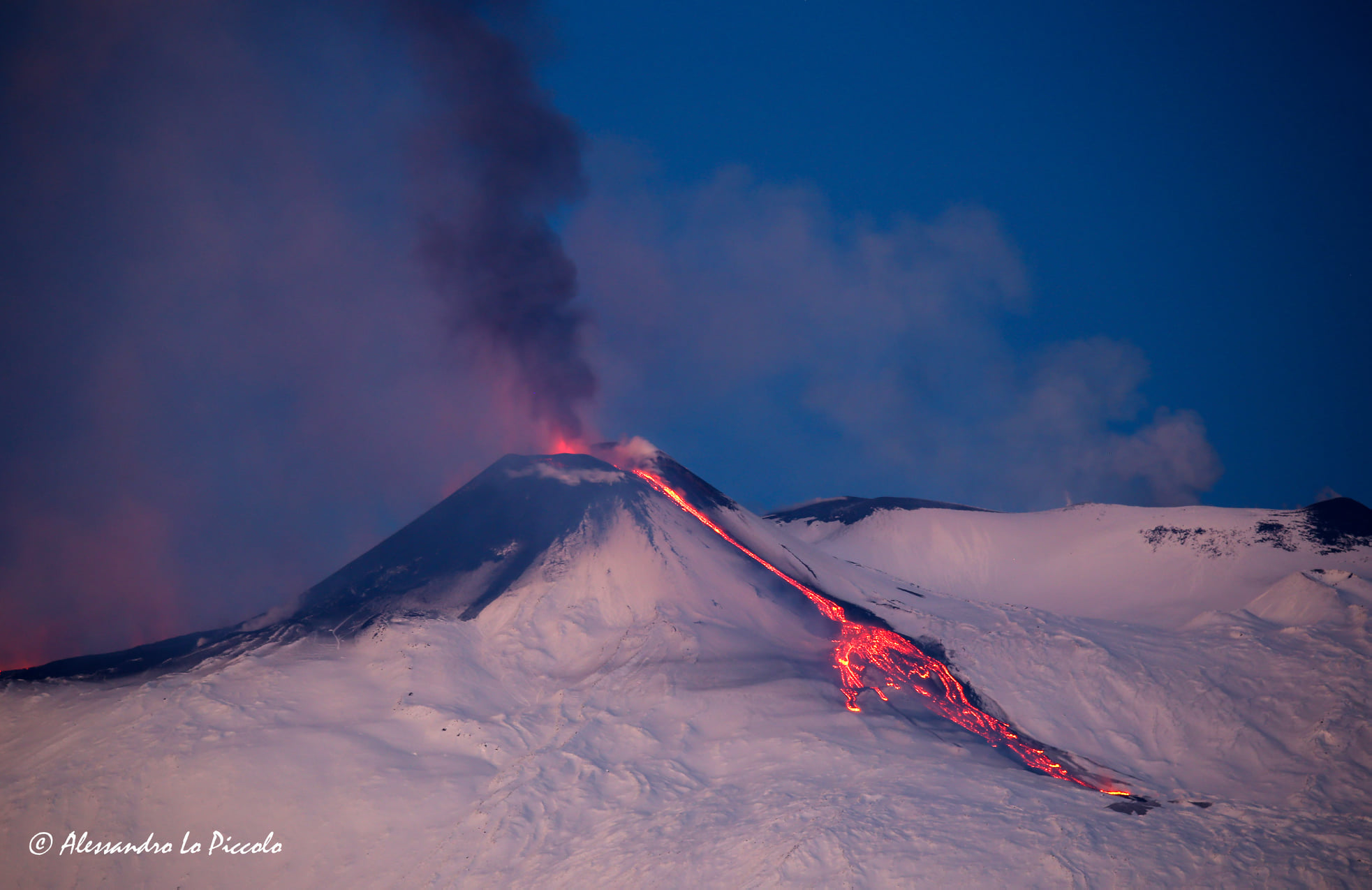
December 30, 2020. EN . Italy / Sicily : Etna , Hawaii : Kilauea , Kamchatka : Karymsky , New Zealand : White Island , Saint Vincent and the Grenadines : Soufrière .

December 30 , 2020 .


Italy / Sicily , Etna :

ETNA COMMUNICATION [UPDATE n. 110]

The National Institute of Geophysics and Volcanology, Osservatorio Etneo, announces that from 06:50 UTC, the video surveillance network showed a gradual intensification of the explosive strombolian activity at the eastern vent of the Southeast crater, with emission associated with ash that the strong winds at high altitude disperse rapidly to the east-northeast. At around 08:00 UTC, this activity intensified further, producing the launch of coarse pyroclastic material over the crater rim which fell back copiously on the eastern slope of the Southeast crater cone. From 09:00 UTC, the intensity of the Strombolian explosive activity decreased considerably as well as the emission of ash became weak and discontinuous remaining confined to the summit area.

Intra-crater Strombolian activity continues, unchanged, at the level of the Voragine and Northeast craters.
Regarding the volcanic tremor, there are no significant changes compared to what was previously communicated. The amplitude remains in the range of the average values, but with modest fluctuations and the source is located in the area of ​​the Southeast crater at an altitude of 2800-2900 m above sea level. With reference to the infrasound activity, it continues to be sustained. It is mainly located in the area of ​​the Northeast crater, and subordinate in the Southeast crater, but it should be noted that the presence of strong wind in the last days could have affected the location of the events. With reference to the increase in amplitude of individual transients, highlighted in the last update, we inform you that for a few days the amplitudes have shown values ​​comparable to those prior to the observed phenomenon.
At present, the inclination and the inclinometric networks of Etna do not present significant variations.

Further updates will be communicated shortly.


Weekly bulletin, from December 21, 2020 to December 27, 2020 (issue date December 29, 2020)

SUMMARY OF THE STATE OF ACTIVITY

In the light of surveillance data, it is highlighted:
1) VOLCANOLOGICAL OBSERVATIONS: Strombolian activity of variable intensity, episodes of lava fountains, emissions of volcanic ash, effusive activity of the Southeast crater. Strombolian activity within the deep crater at the Northeast crater and at the Bocca Nuova crater with rare and diluted ash emissions. Intermittent explosive activity at the crater of Voragine with occasional and diluted ash emissions.
2) SEISMOLOGY: low fracturing seismicity; amplitude of the tremor on average in the range of medium and medium-high values ​​with phases of sudden increase linked to intense volcanic activity.
3) INFRASON: high infrasound activity
4) DEFORMATIONS: There are no significant variations for the GNSS network.
In parallel with the eruptive activity of December 21 and 22, the inclinometric network recorded small transient deformations in the high and medium altitude stations.
5) GEOCHEMISTRY: SO2 flux: medium level
HCl flow occurs at an average level.
The CO2 flux from the soil is at average levels.
The partial pressure of dissolved CO2 does not show significant changes.
The value of the C / S ratio is at medium-low levels (last measurement dated 10/16/2020).
The isotope ratio of helium is at average values ​​(last update of 12/16/2020).
6) SATELLITE OBSERVATIONS: The thermal activity in the summit area is at a moderate level.

VOLCANOLOGICAL OBSERVATIONS

During the week, the monitoring of the volcanic activity of Etna was carried out by analyzing the images of the network of surveillance cameras of the INGV, Osservatorio Etneo (INGV-OE), from two inspections carried out by INGV-OE staff on December 21 and 22 and an overflight carried out on December 27 using a helicopter (AW 139, VF 142) provided by the Catania Fontanarossa flight service of the CNVVF.
Adverse weather conditions for part of the week made the observation of volcanic activity discontinuous.

In general, during the week, the activity of Etna had a behavior quite similar to that observed the previous week (Rep. N ° 51/2020) with a Strombolian activity of variable intensity at the Southeast crater (CSE ), which produced ash emissions and the launching of lava shreds, while the northeast craters and Bocca Nuova produced intracrater strombolian activity of varying intensity, accompanied by sporadic emissions of dilute ash. Finally, the Voragine crater produced a discontinuous explosive activity and slight ash emissions.
In detail, the Strombolian activity at the Southeast Crater (CSE) was of variable intensity and almost continuous both at the East Vent (Fig.3.1) and at the more central vent, with the jet of shreds of lava above the vent and the product rolling along the walls of the cone.

From 09:08 UTC on December 21, the surveillance networks recorded a strong intensification of Strombolian activity in the Southeast Crater (CSE). This activity involved at least two of the mouths of the Southeast Crater at the same time and quickly escalated, evolving into a lava fountain a few minutes later, producing an eruptive column that was pushed by high altitude winds to the North -East and whose height has been estimated on the basis of satellite observations at about 10 km above sea level.
The activity of the lava fountain of the Southeast Crater ends after about an hour and, starting at 11:03 UTC, following a very brief improvement in the visibility conditions at the summit, a lava flow is observed from the niche which opened on the south-western flank of the CSE on the evening of December 13, in a south-western direction. At 14:21 UTC, it was possible to observe a second lava flow from the southern slope of the Southeast crater, directed towards the valley of Bove.

At 02:50 UTC on December 22, a further increase in the Strombolian activity of the central and eastern vents of the CSE feeds, from around 03:15 UTC, a lava flow from the southwest flank of the southeast crater which forms a West-directed lava flow, which overlaps the cooling lava field of December 21, 2020.
From 04:19 UTC, Strombolian activity suddenly turned into a lava fountain. The activity feeds three lava flows: the first goes to the southwest and branches off to the west and east of Monte Frumento Supino. The second is heading towards Valle del Bove straddling the lava flow of December 21. The third, which has its source on the east side of the south-eastern crater, heads east-north-east, in the Valle del Leone.
From around 05:00 UTC, the lava fountain episode gradually subsided until it ceased and the lava flows showed gradual cooling.

On December 23, high intensity explosions occurred at the Southeast Crater, which generated a significant fallout of matter on the cone and a seismic and infrasound transient.
On December 24, at approximately 07:30 UTC, further intensification of explosive activity was observed from the East Vent of the Southeast Crater, which produced the launch of products above the crater rim and the emission of ash , scattered to the east. This activity continues with varying frequency and intensity even on subsequent days.
The lava field consists of three arms, the largest of which develops in a southwest direction, starting from the southern flank of the Southeast crater. It is 2.8 km long and its maximum width is 0.6 km, measured just south of the 1971 cone, while the front is at an altitude of 2450 m. At an altitude of about 3050 m, the main arm separates, generating a secondary arm directed towards the South which rests against the north wall of the cones of 2002-2003 and of the M. Frumento Supino. (see map above)

The second branch develops in an easterly direction, follows the trajectory of the flow of May 2019 towards the Valle del Bove and reaches an altitude of about 2200 m, for a length of at least 2.8 km.
The third arm extended in an east-northeast direction from the eastern part of the south-eastern crater, extending into the Valle del Leone for about 1.3 km and reaching an altitude of about 2650 m .
The investigation highlighted the morphological evolution undergone by the South-East crater after December 13-14: the crater has an irregular elliptical shape open towards the South-West, the major axis of which measures 230 m and the minor axis 150 mr.
Finally, during the week, the North-East and Bocca Nuova craters produced intracrater Strombolian activity of varying intensity, accompanied by sporadic emissions of dilute ash, while the Voragine crater produced explosive activity. discontinuous and moderate emissions of scattered ash in the summit area

Source : INGV.

Read the articles http://www.ct.ingv.it/Dati/informative/vulcanico/ComunicatoETNA20201229094204.pdf

                                    http://www.ct.ingv.it/index.php/monitoraggio-e-sorveglianza/prodotti-del-monitoraggio/bollettini-settimanali-multidisciplinari/403-bollettino-settimanale-sul-monitoraggio-vulcanico-geochimico-e-sismico-del-vulcano-etna20201229/file

Photo : Gio Giusa. Boris Behncke , INGV , Alessandro lo Piccolo .


Hawaii , Kilauea :

19°25’16 » N 155°17’13 » W,
Summit Elevation 4091 ft (1247 m)
Current Volcano Alert Level: WATCH
Current Aviation Color Code: ORANGE

Activity Summary:
Lava activity is confined to Halemaʻumaʻu with lava erupting from a vent on the northwest side of the crater. As of 4 am this morning (Dec. 29), the lava lake was 179-180 m (587-591 ft) deep with a narrow black ledge around it. Reduced, but still elevated, SO2 emissions were measured yesterday (Dec. 28).


Summit Observations:
Preliminary analysis of sulfur dioxide emission rates measured yesterday (Dec. 28) show that the rates about 3,300 tonnes/day– slightly lower than the Dec. 27 rate of 5,500 t/d, but still elevated; both values were in the range of emission rates common for the pre-2018 lava lake. Summit tiltmeters continued to record weak inflationary tilt until about 4 pm yesterday (Dec. 28) when it switch to intermittent weak deflationary tilt. Seismicity remained elevated but stable, with steady elevated tremor and a few minor earthquakes.

East Rift Zone Observations:
Geodetic monitors indicate that the upper portion of the East Rift Zone contracted while the summit deflated. This was associated with magma withdrawal to feed the summit vents. There is no seismic or deformation data to indicate that magma is moving into either of Kīlauea’s rift zones.

Halemaʻumaʻu lava lake Observations:
The west vent continued erupting lava into a lava lake within Halemaʻumaʻu crater with two or three narrow channels visible this morning.

This photo, taken at approximately 5:30 a.m. December 29, 2020, shows Kīlauea’s ongoing summit eruption. The western vent in the wall of Halema‘uma‘u continued to erupt overnight, and the northern/eastern vent remained inactive. At approximately 3:45 a.m. HST today (Dec. 29), HVO field crews measured the lava lake as 179 m (587 ft) deep.

The lava lake within Halemaʻumaʻu crater has changed little in the past day and was about 179-180 m (587-591 ft) deep as of this morning (Dec. 29). The lake volume was slightly more than 22 million cubic meters (29 million cubic yards or 5 billion gallons). The most recent thermal map (Dec. 28) provided the lake dimensions as 770 by 490 m (840 by 535 yds) for a total area of 29 ha (72 acres). The narrow (10-30 m or 11-22 yd) ledge around the lake was about 1-2 m (1-2 yds) above the active lake surface .

Over the past day, the main island of cooler, solidified lava floating in the lava lake drifted slowly westward in the lake until about 10 pm last night (Dec. 28) when it stalled along with 10 or so much smaller islands to the east. The main island measured about 250 m (820 ft) in length, 135 m (440 ft) in width, and about 3 ha (7 acres) in area based on the Dec. 28 thermal map. This morning, the main island is still stalled but is rotating slowly. Measurements on Dec. 27 show that the island surface was about 6 m (20 ft) above the lake surface.

Source : HVO.

Photos : Bruce Omori , USGS photo by H. Dietterich. 


Kamchatka , Karymsky :

VOLCANO OBSERVATORY NOTICE FOR AVIATION (VONA).

Issued: December 30 , 2020
Volcano: Karymsky (CAVW #300130)
Current aviation colour code: ORANGE
Previous aviation colour code: orange
Source: KVERT
Notice Number: 2020-256
Volcano Location: N 54 deg 2 min E 159 deg 26 min
Area: Kamchatka, Russia
Summit Elevation: 4874.08 ft (1486 m)

Volcanic Activity Summary:
The explosive activity of Karymsky volcano continues. Ash clouds are drifting to the westnorthwest of the volcano.
A moderate explosive activity of the volcano continues. The ash explosions up to 16,400-23,000 ft (5-7 km) a.s.l. could occur at any time. Ongoing activity could affect low-flying aircraft.

Volcanic cloud height:
13120 ft (4000 m) AMSL Time and method of ash plume/cloud height determination: 20201230/0140Z – Himawari-8

Other volcanic cloud information:
Distance of ash plume/cloud of the volcano: 37 mi (60 km)
Direction of drift of ash plume/cloud of the volcano: WNW / azimuth 295 deg
Time and method of ash plume/cloud determination: 20201230/0140Z – Himawari-8

Source : Kvert.

Photo : D. Melnikov, IVS FEB RAS, KVERT ( Mai 2019).


New Zealand , White Island :

Small steam explosions recorded at Whakaari/White Island . Published: Wed Dec 30 2020 5:15 PM

Volcanic Alert Level remains at 1
Aviation Colour Code remains at Green

A series of short-lived, low energy steam explosions occurred on 29 December 2020 at Whakaari / White Island over a period of ~ 30 mins. This small event consisted of at least 20 individual pulses and may have produced traces of ash locally in the steam plume for a few minutes. Since the event, activity has returned to low-level. The Volcanic Alert Level remains at 1.

Starting at around 3 pm on Tuesday 29 December, a series of small steam explosions were detected on our seismic and acoustic (air pressure) sensors at Whakaari/White Island. Images from the island’s webcams suggest some more vigorous pulses of steam coming from the active vent during that time. Ash was not detected in the atmosphere via satellite images by our colleagues at Metservice, but minor traces of ash might have been present near the vent for a few minutes during the steam explosions. The overall series of pulses lasted for about 30 min.

Sudden, small steam explosions can occur with little or no warning. While changes in the appearance of the steam emission at the surface can be subtle and may be difficult to see on the webcams, such small explosions can be recorded on our seismic (ground vibrations) and acoustic (pressure wave in the atmosphere) monitoring network.

The level of seismic tremor had been slightly above background in the previous two days but has since dropped back down to background levels. Gas emissions (Sulfur dioxide) also remain largely unchanged and we have seen very few discrete earthquakes. As a result, the Volcanic Alert Level remains at 1 and the Aviation Colour Code remains at Green.

The Volcanic Alert Level reflects the current level of volcanic unrest or activity and is not a forecast of future activity. Volcanic Alert Level 1 indicates the primary hazards are those expected during volcanic unrest; including discharge of steam and hot volcanic gases, earthquakes, landslides and hydrothermal activity. While Volcanic Alert Level 1 is mostly associated with environmental hazards, eruptions can still occur with little or no warning. The main plausible triggers for a sudden eruption remain the collapse of unstable material in an active vent and the possible ingress of water underground onto the shallow magma body.

Source et photo : Geonet  / Agnes Mazot  Duty Volcanologist.


Saint Vincent and the Grenadines , Soufrière :

Saint Vincent and the Grenadines are on orange alert. Today effusive eruptions have been recorded in the crater of the volcano, La Soufrière. Scientists confirm the presence of magma in the crater and fear an explosive eruption.

Since the morning of December 29, 2020, gas and magma have been escaping from the crater of the Soufriere volcano in Saint Vincent and the Grenadines.


Today the crater lake is gone, the water evaporating with the heat of volcanic activity. Experts fear a possible explosive eruption.

Visits to this site, which is very popular with locals and tourists, are now prohibited. The population living near the volcano is on alert. If the situation worsens, they will be forced to evacuate.

Scientists from the Seismic Center at the University of the West Indies in Trinidad and Tobago will be on site in a few hours. An increase in seismic activity around Soufrière has been recorded since November 1, 2020.

The last eruption of Soufrière, located in the far north of the island, dates back to 1979.

Source :  la1ere.francetvinfo.fr.

Photo : Via Vulcanologia Esia .