June 20 , 2024.
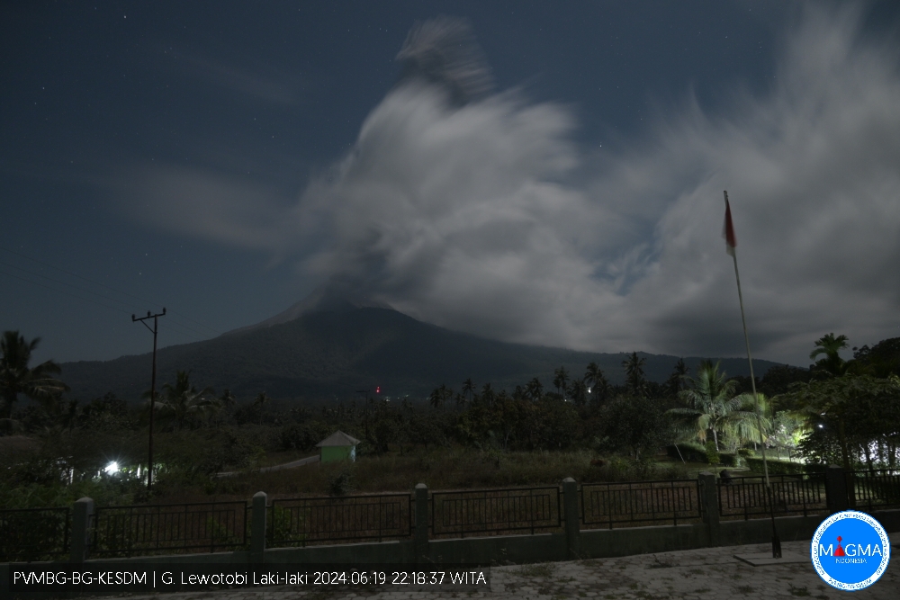
Indonesia , Lewotobi Laki-laki :
PVMBG reported that eruptive activity at Lewotobi’s Laki-laki volcano continued during 12-18 June. Multiple eruptive events were recorded daily by the seismic network daily. Daily gray or white-and-gray ash plumes rose 100-1,000 m above the summit and drifted SW, W, and NW. According to news articles ashfall was reported during 12-13 June in villages to the NW and NE, including Klatanlo (5 km NW), Hokeng Jaya (4 km NW), Persiapan Padang Pasir, Nawokote (5 km W), and Boru (8 km WNW) in the Wulanggitang District, along with Nobo (5 km NE) and Dulipali (6 km NNW) in the Ile Bura District. Workers sprayed water on several streets to wash off the ashfall. On 15 June ashfall was reported in areas to the SW including the communities of Padang Pasir, Wotupudor, and Kumaebang, and in Boru village. On 16 June ashfall affected the Frans Seda Sikka (60 km WSW) and Haji Hasan Aroeboesman Ende (126 km WSW) airports, causing disruptions to flights at Frans Seda Sikka. The Alert Level remained at 2 (the second lowest level on a scale of 1-4) and the public was warned to stay outside of the exclusion zone, defined as a 2-km radius around Laki-laki crater, 3 km to the NNE, and 5 km on the NE flanks.
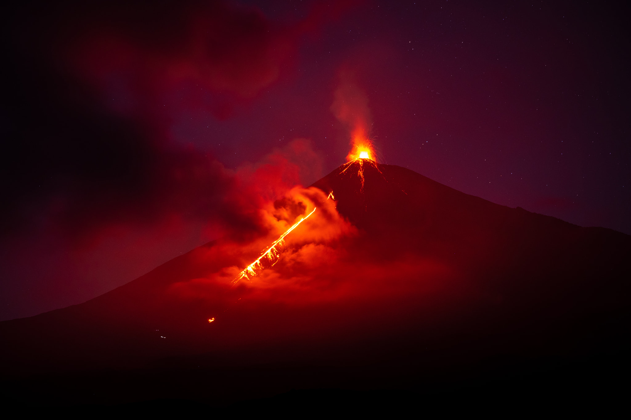
VOLCANO OBSERVATORY NOTICE FOR AVIATION – VONA
Issued : June 19 , 2024
Volcano : Lewotobi Laki-laki (264180)
Current Aviation Colour Code : ORANGE
Previous Aviation Colour Code : orange
Source : Lewotobi Laki-laki Volcano Observatory
Notice Number : 2024LWK092
Volcano Location : S 08 deg 32 min 20 sec E 122 deg 46 min 06 sec
Area : East Nusa Tenggara, Indonesia
Summit Elevation : 5069 FT (1584 M)
Volcanic Activity Summary :
Eruption with volcanic ash cloud at 23h31 UTC (07h31 local).
Volcanic Cloud Height :
Best estimate of ash-cloud top is around 7949 FT (2484 M) above sea level or 2880 FT (900 M) above summit. May be higher than what can be observed clearly. Source of height data: ground observer.
Other Volcanic Cloud Information :
Ash cloud moving from southwest to west. Volcanic ash is observed to be gray. The intensity of volcanic ash is observed to be thick.
Remarks :
Eruption recorded on seismogram with maximum amplitude 47.3 mm and maximum duration 392 second.
Sources : Pusat Vulkanologi dan Mitigasi Bencana Geologi (PVMBG, also known as CVGHM), Antara News, Antara News, Antara News , GVP
Photo : Magma Indonésie.
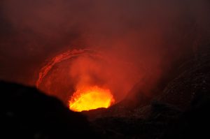
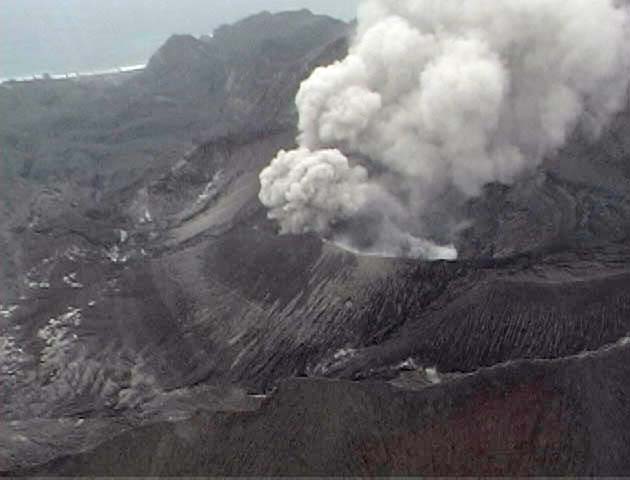
Guatemala , Fuego :
Altitude: 3,763 meters
Weather conditions: cloudy
Wind: South-West
Precipitation: 26.8 mm.
Activity:
The atmospheric conditions do not allow the explosive activity of the Fuego volcano to be observed. However, monitoring stations record 3 to 6 explosions per hour with weak to moderate characteristics. Due to the wind direction and speed according to the WRF numerical model, the columns of gas and ash generated by said explosions rise up to 4,500 meters above sea level (14,763 feet) and extend over 10 to 30 km in an east and northeast direction. The explosions are accompanied by weak to moderate avalanches, weak to moderate rumbles, weak to moderate shock waves, and incandescent pulses. The above could generate fine ash falls in towns located to the east and northeast of the volcano, such as San Miguel Dueñas, Ciudad Vieja and Antigua Guatemala. Regarding explosive activity, follow the recommendations described in special bulletin BEFGO-003-2024.
INSIVUMEH reported that eruptive activity continued on Fuego from June 11 to 18. Daily explosions were recorded by the seismic network, averaging 3 to 9 per hour on most days when counts were reported. The explosions generated plumes of gas and ash that rose up to 1.1 km above the crater rim and drifted up to 30 km in several directions. Weather conditions often prevented visual observations during the second half of the week, although explosions and boulder avalanches were recorded by instruments and could often be heard. The explosions produced avalanches of blocks that rolled down various slope ravines, including: Ceniza (South-Southwest), Seca (West), Taniluyá (Southwest), Las Lajas (Southeast) and Honda (East), and often reached areas of vegetation. Low rumbling sounds and shock waves shaking nearby homes and buildings were reported most of the time. Ashfall was reported on June 11-12 and 15-16 in leeward areas, including Acatenango (8 km east), La Soledad (11 km north), Parramos (18 km north- North-East), Patzicia (17 km North-North-West) and Yepocapa (8 km North-West). Ashfall was forecast in leeward areas on some other days. The explosions also ejected incandescent material up to 100-400 m above the summit on June 11-13 and 16-17. On June 12, lahars moved down the Las Lajas and Ceniza watersheds, carrying tree branches, trunks and blocks measuring up to 1.5 m in diameter.
Source : Insivumeh , GVP
Photo : Diego Rizzo .
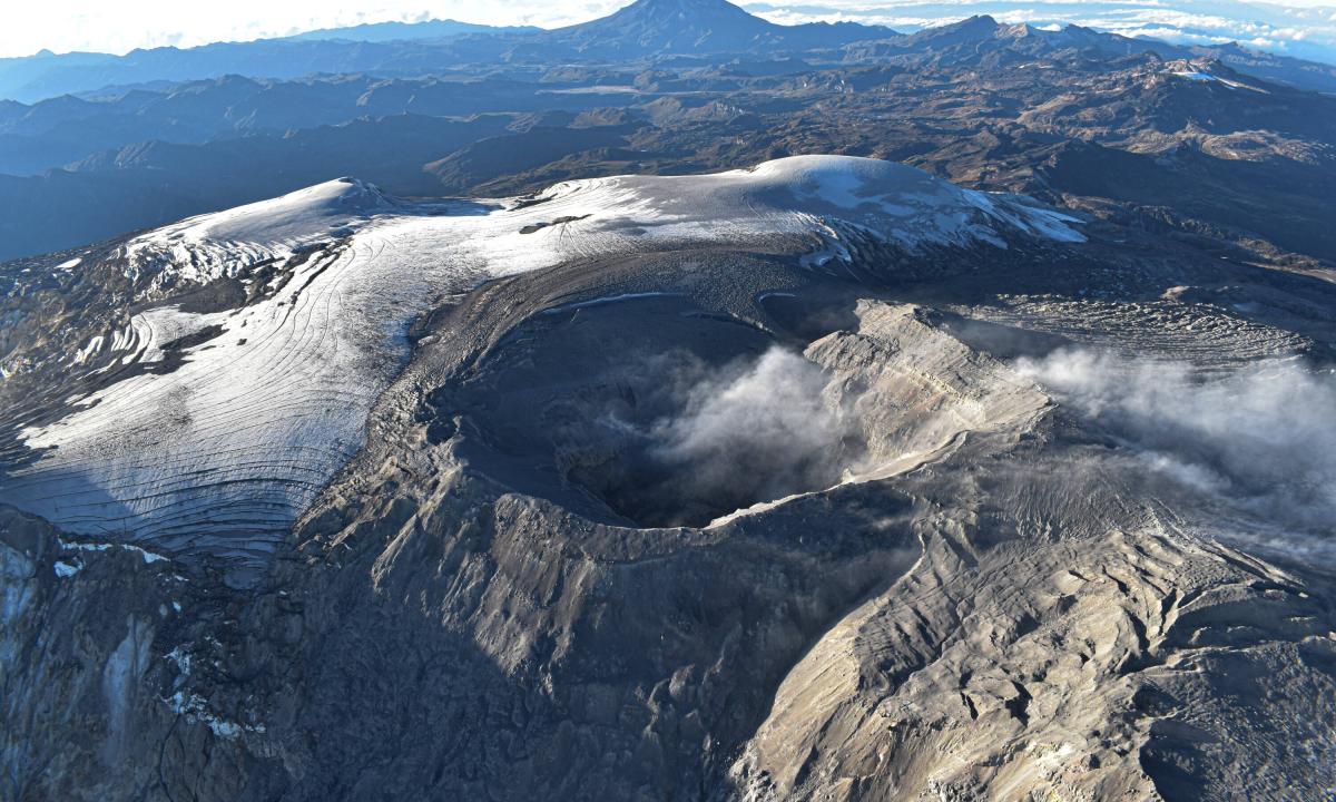
Colombia , Nevado del Ruiz :
Manizales, June 18, 2024, 6:20 p.m.
Weekly activity bulletin: Nevado del Ruiz Volcano
Regarding the monitoring of the activity of the NEVADO DEL RUIZ VOLCANO, the COLOMBIAN GEOLOGICAL SERVICE (SGC), an entity attached to the MINISTRY OF MINES AND ENERGY, reports that:
In the week of June 4 to 10, 2024, the volcano continued with unstable behavior. Compared to the previous week, the main variations in the parameters monitored were:
– Seismicity related to fluid dynamics within volcanic conduits has decreased in the number of earthquakes recorded and maintained similar levels of seismic energy released. Some seismic signals were associated with pulsatile emissions of ash and gas into the atmosphere.
These seismic signals presented variable energy levels with generally low values. Long-lasting signals were occasional. Although high cloudiness persists in the volcanic area, thanks to the cameras used to monitor the volcano it has been possible to confirm several ash emissions and changes in the temperature of the emitted materials associated with some of these seismic events. The seismic signal recorded today June 18 at 2:27 a.m. stands out for being the most energetic of the week, reaching moderate energy levels. This signal was associated with ash emission and relative changes in the temperature of the emitted material were observed.
– Seismic activity associated with the fracturing of rocks inside the volcanic edifice has decreased in the number of earthquakes recorded and increased in the seismic energy released. The earthquakes were located mainly in the Arenas crater and in the south-southwest sector of the volcano and, to a lesser extent, on the north-eastern flank, at distances less than 10 km from the crater. Depths of the events varied from less than 1 km to up to 7 km from the volcano summit. The highest magnitude of the week was 1.4, corresponding to the earthquake recorded on June 15 at 7:16 a.m., located approximately 2 km south-southwest of the crater and 3 km deep. In addition, the seismicity linked to the activity of the lava dome (protrusion or mound) located at the bottom of the crater continued, however, it decreased in the number of earthquakes recorded compared to the previous week. Episodes of this type of seismicity were of low energy level and short duration.
– On the volcano, the emission of water vapor and gas into the atmosphere from the Arenas crater continues. Sulfur dioxide (SO₂) outgassing rates were variable and showed similar levels compared to the previous week. The maximum vertical and dispersion height of the gas column, estimated above the volcano summit, was 1,000 and 2,000 m, respectively. These heights were associated with the ash emission presented today June 18 at 2:27 a.m. The direction of dispersion of the gas column during the week was variable with a preferential tendency towards the North-West and West-South-West flanks of the volcano.
– When monitoring surface activity from satellite monitoring platforms, the detection of thermal anomalies at the bottom of Arenas Crater continued to be limited by the heavy cloudiness conditions in the area. However, this week detected anomalies were reported showing low to moderate energy levels.
It is not excluded that continuous and pulsed emissions of gas and ash continue to occur which, depending on the wind regime prevailing at the time of the emission, disperse towards population centers, generating damage due to the fall of this material. On the other hand, in this state of volcanic alert, earthquakes can occur and be felt.
Source et photo : SGC
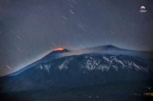
Japan , Suwanosejima :
JMA reported that eruptive activity at Suwanosejima’s Ontake Crater continued during 10-17 June and produced volcanic plumes that rose as high as 800 m above the crater rim. Crater incandescence was observed nightly in webcam images. No explosions were recorded. The Alert Level remained at 2 (on a 5-level scale) and the public was warned to stay at least 1.5 km away from the crater.
The 8-km-long island of Suwanosejima in the northern Ryukyu Islands consists of an andesitic stratovolcano with two active summit craters. The summit is truncated by a large breached crater extending to the sea on the E flank that was formed by edifice collapse. One of Japan’s most frequently active volcanoes, it was in a state of intermittent Strombolian activity from Otake, the NE summit crater, between 1949 and 1996, after which periods of inactivity lengthened. The largest recorded eruption took place in 1813-14, when thick scoria deposits covered residential areas, and the SW crater produced two lava flows that reached the western coast. At the end of the eruption the summit of Otake collapsed, forming a large debris avalanche and creating an open collapse scarp extending to the eastern coast. The island remained uninhabited for about 70 years after the 1813-1814 eruption. Lava flows reached the eastern coast of the island in 1884. Only about 50 people live on the island.
Sources : Japan Meteorological Agency (JMA), GVP
Photo : eri .u tokyo.ac ( archive)
Kamchatka , Bezymianny :
55.97 N, 160.6 E;
Elevation 2882 m (9453 ft)
Aviation Colour Code is YELLOW
An effusive eruption of the volcano continues. Ongoing activity could affect low-flying aircraft.
An effusive eruption of the volcano (extruding a viscous lava flow onto the eastern slopes of the dome) continues, it is accompanied by powerful gas-steam activity and sometimes by an incandescence of the lava dome. Satellite data by KVERT showed a thermal anomaly over the volcano on June 6-9, and 11-13; the volcano was obscured by clouds during other days of the week.
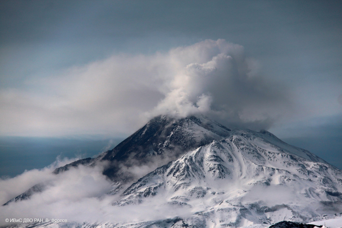
KVERT reported that a thermal anomaly over Bezymianny was identified in satellite images during 6-9 and 11-13 June. Weather clouds prevented views on 10 June. Dates are UTC; specific events are in local time where noted.
Sources : KVERT , GVP.
Photo : V. Frolov. IVS FEB RAS