June 16 , 2024.
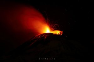
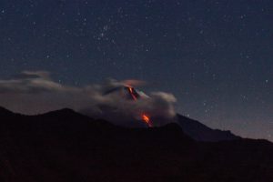
Ecuador , Reventador :
Since March 21, 2024, thanks to the regional seismic network, an increase in the number and amplitude of explosions recorded on the El Reventador volcano has been detected. This increase was accompanied by a slight increase in SO2 degassing measured by satellite instruments. However, the characteristics of ash emissions have not changed and remain at the usual levels of the volcano. On the other hand, several morphological changes have occurred in the crater area, which facilitate the generation of small pyroclastic flows towards the South and Southeast flanks of the volcanic cone. It is important to emphasize that until now, these flows have been low and have not generated any impact on populated areas or infrastructure near the volcano. The deposits generated by this activity are easily remobilized by rain and it is therefore important to maintain vigilance in the drainages which descend along the southern flank of the volcano since medium to small lahars could be generated.
From May 2, small deposits of pyroclastic flows began to be observed on the southeast flank of the volcano, and later the good climatic conditions made it possible to observe the flows responsible for these deposits. This phenomenon became common and could be observed several days later, from May 5, until the date of publication of this report. The range of these flows is variable and varies from 0.5 km to 1.2 km on the southeast flank of the volcano.
The width of the depression that favored the generation of pyroclastic flows is approximately 125 m, and from this two small streams are formed, which, in the upper area, have a variable width of 50 to 60 meters. The streams have a total length of approximately 1.2 km on the south and southeast flanks.
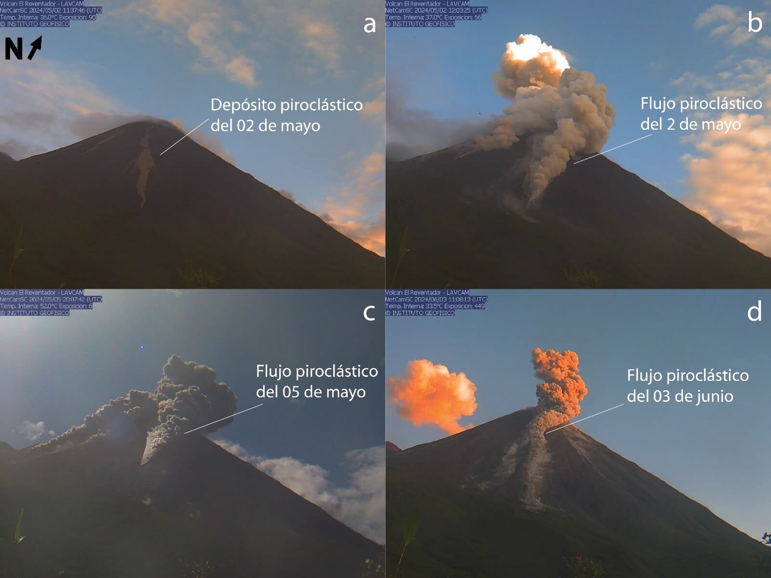
The most likely short-term (days to weeks) eruptive scenario is that this activity continues and continues to generate small pyroclastic flows. As long as they remain within the sizes observed so far, they do not pose a direct threat to populated areas or infrastructure. However, as these continue to descend, they produce an accumulation of loose volcanic material towards the base of the volcanic cone, material which would be easily remobilized by rainfall, with the consequent generation of lahars. Due to their location, these flows would flow down the Marker River.
In the event of an increase in the rate of magma rise and, consequently, the surface activity of the volcano, greater flank collapses could occur, greater pyroclastic flows and possibly emission of lava flows, as has happened on previous occasions (e.g. 2018, 2022). The areas affected depend on the volume of material that can collapse and the volume of lava emitted. On previous occasions, these phenomena have reached up to 2.5 km from the crater. This scenario is less likely, but it should be considered.
At the time of issuance of this document, the volcano maintains its levels of high surface activity without change, and moderate internal activity without change.
Source : IGEPN
Photos : S. Hidalgo – IGEPN , IGEPN.
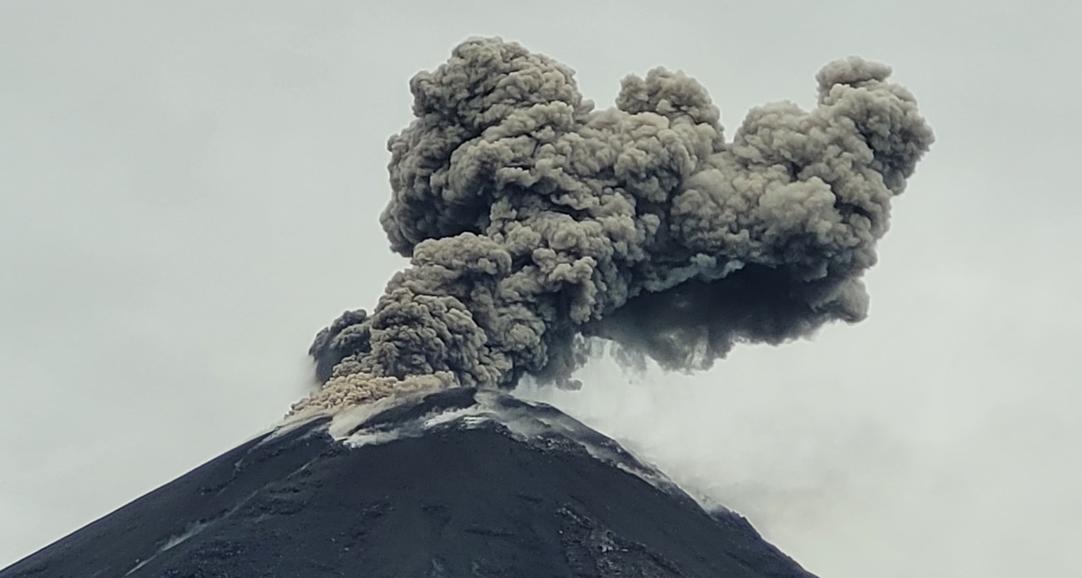
Indonesia , Ibu :
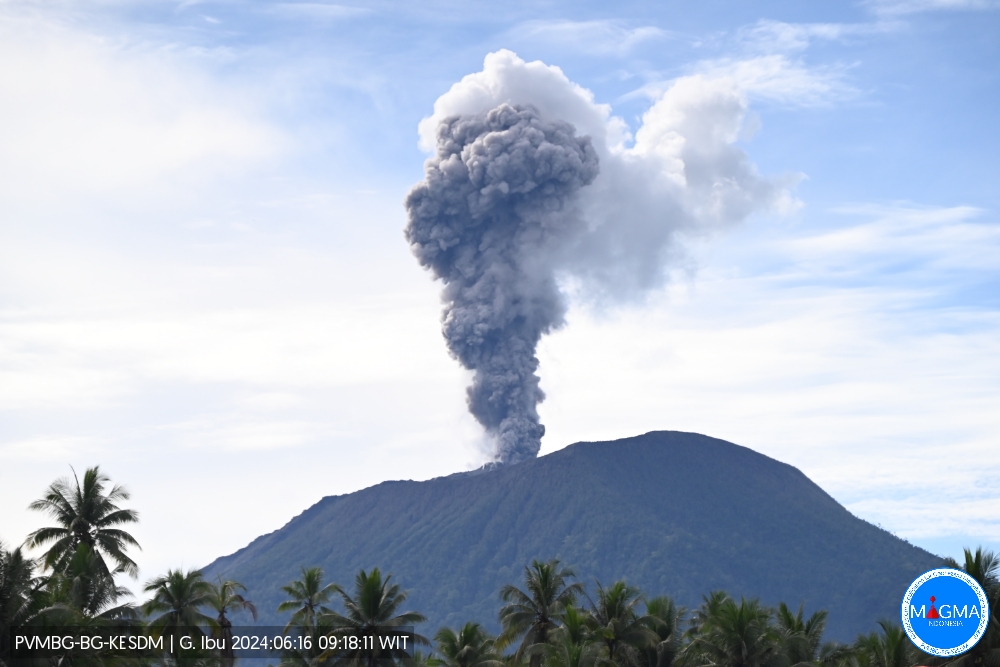
An eruption of Mount Ibu occurred on Sunday 16 June 2024 at 09:16 WIT with the height of the ash column observed at ±1,500 m above the summit (±2,825 m above sea level) . The ash column was observed to be gray to brown in color with thick intensity, oriented towards the East and South-East. This eruption was recorded on a seismograph with a maximum amplitude of 17 mm and a duration of 145 seconds.
Observation of seismicity:
2 eruption earthquakes with an amplitude of 17 to 28 mm and a seismic duration of 118 to 145 seconds.
3 emission earthquakes with an amplitude of 10 to 28 mm and duration of the earthquake of 48 to 60 seconds.
1 harmonic tremor with an amplitude of 4 mm, and an earthquake duration of 46 seconds.
207 Shallow volcanic earthquakes with an amplitude of 2 to 11 mm and an earthquake duration of 4 to 14 seconds.
10 deep volcanic earthquakes with an amplitude of 2 to 4 mm, and an earthquake duration of 6 to 12 seconds.
6 distant tectonic earthquakes with an amplitude of 2 to 12 mm, and the duration of the earthquake was 39 to 120 seconds.
RECOMMENDATION
1. Communities around Mount Ibu and visitors/tourists should not carry out activities within a radius of 4 km with a sectoral extension of 7 km towards the crater opening in the northern part of the active Mount Ibu crater.
2. In the event of ash falling, people who carry out activities outside the house are advised to protect their nose, mouth (mask) and eyes (glasses).
Source et photo : Magma Indonésie.
Iceland , Reykjanes Peninsula :
The map shows the extent and thickness of the lava bed that formed during the eruption that began on May 29. The map is the result of the collaboration of many parties, but it is based on the measurements of Verkís, Efla and Svarma from June 10. The image measurement team of the National Institute of Natural Sciences and Surveying processed the data. The map shows where lava has accumulated in a lava pond southeast of Sýlingarfell (red area) and the lava stream flowing from it to the north of Sýlingarfell. Gray areas show lava that has flowed into the area since December 2023.
The data shows that the area of the lava bed has increased to 9.2 km2 and its volume is about 41 million m3. Thus, the lava bed formed during this eruption is the largest in area and volume of the five volcanic eruptions that have occurred in the Sundhnúks crater series since December 2023. In comparison, the lava bed formed during the eruption which started on March 16 and lasted until May 9, measures approximately 6.2 km2 in area and 35 million m3.
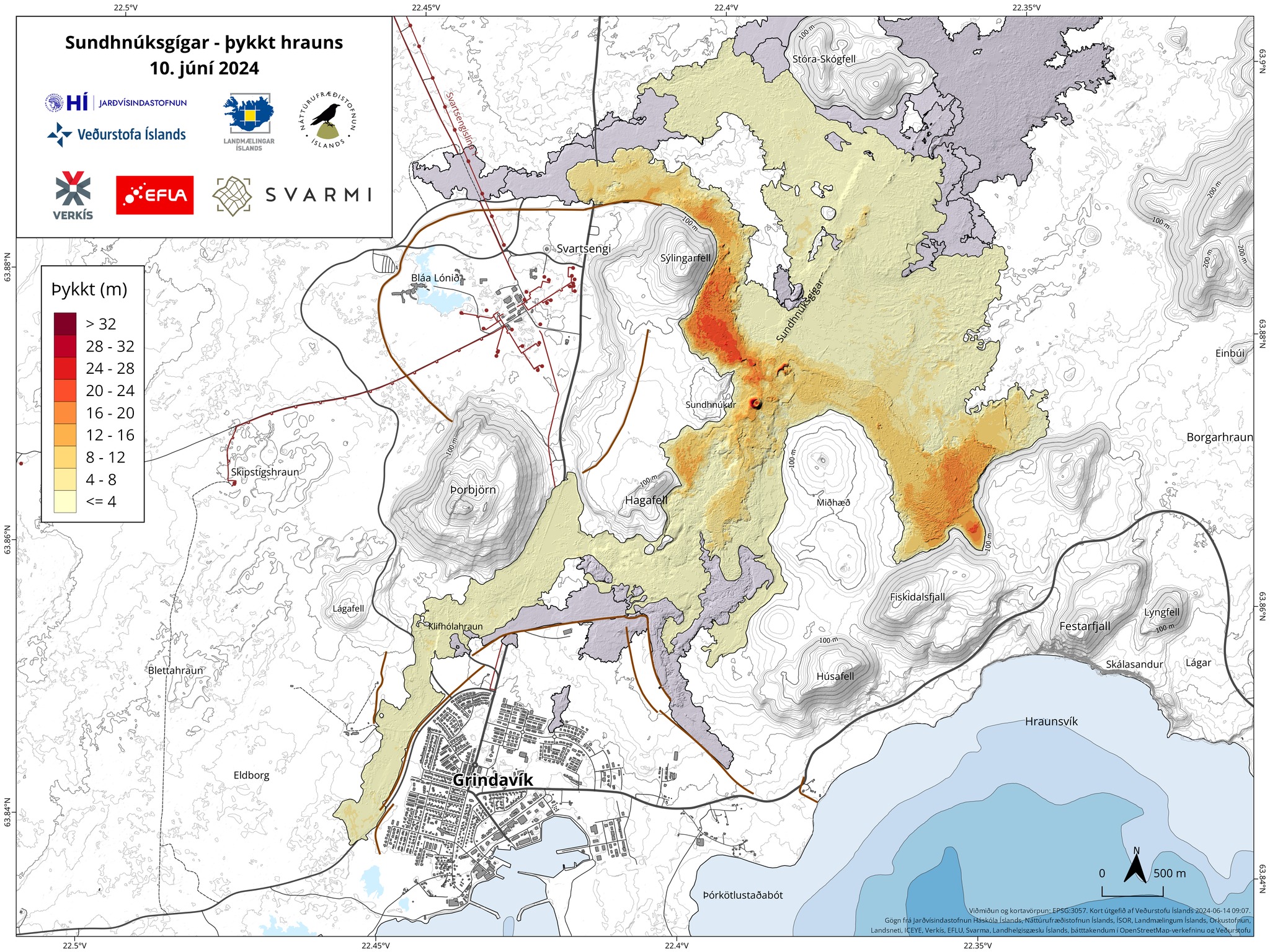
Map showing the extent and thickness of the lava bed that formed during the eruption that began on May 29. The map is the result of the collaboration of many parties, but it is based on the measurements of Verkís, Efla and Svarma from June 10. The map shows where lava has accumulated in a lava pond southeast of Sýlingarfell (red area) and the lava stream flowing from it to the north of Sýlingarfell. Gray areas show lava that has flowed into the area since December 2023.
Based on these data, the average lava flow from the eruption between June 3 and 10 is estimated at 10 m3/s. From the afternoon of May 29 to June 3, the lava flow was estimated at 27 m3/s, so the eruption subsided somewhat between these two measurements.
Source et photo : IMO.
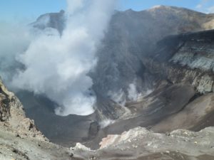
Colombia , Puracé :
Popayan, June 15, 2024, 4:00 p.m.
Concerning the monitoring of the activity of the PURACE VOLCANO – LOS COCONUCOS VOLCANIC RANGE, the COLOMBIAN GEOLOGICAL SERVICE (SGC), an entity attached to the MINISTRY OF MINES AND ENERGY, reports that:
Until the time of publication of this bulletin, both the number of seismic events and the seismic energy released remain at levels similar to those recorded yesterday, a behavior observed for both fracture and fluid seismicity. Earthquakes associated with rock fracturing continue to be located mainly under the building of the Puracé volcano, as well as on its northwest flank, at depths between 0.5 and 2 km;Fluid seismicity, for its part, continues to be located mainly under the crater of the Puracé volcano with a depth of less than 1 km and, to a lesser extent, on the North-West and East flanks of the volcanic edifice at depths between 0.5 and 2km.
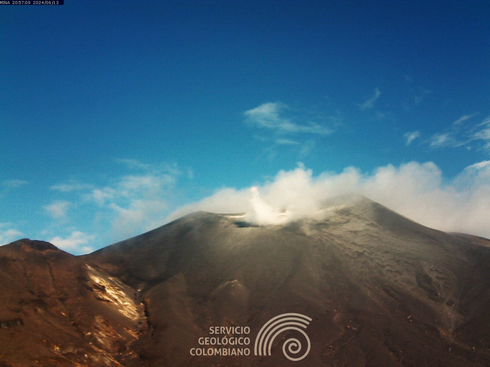
The maximum height of the gas column that could be observed between yesterday afternoon and today was approximately 430 m, measured from the summit of the volcano and with a direction of dispersion towards the South-West. Ground deformation processes and carbon dioxide (CO2) and sulfur dioxide (SO2) gas concentrations maintain the observed trend, with values remaining above the known baselines for this volcano.
The SGC confirms that the alert state of the PURACÉ VOLCANO continues in ORANGE: volcano with significant changes in the monitored parameters
Source et photo : SGC
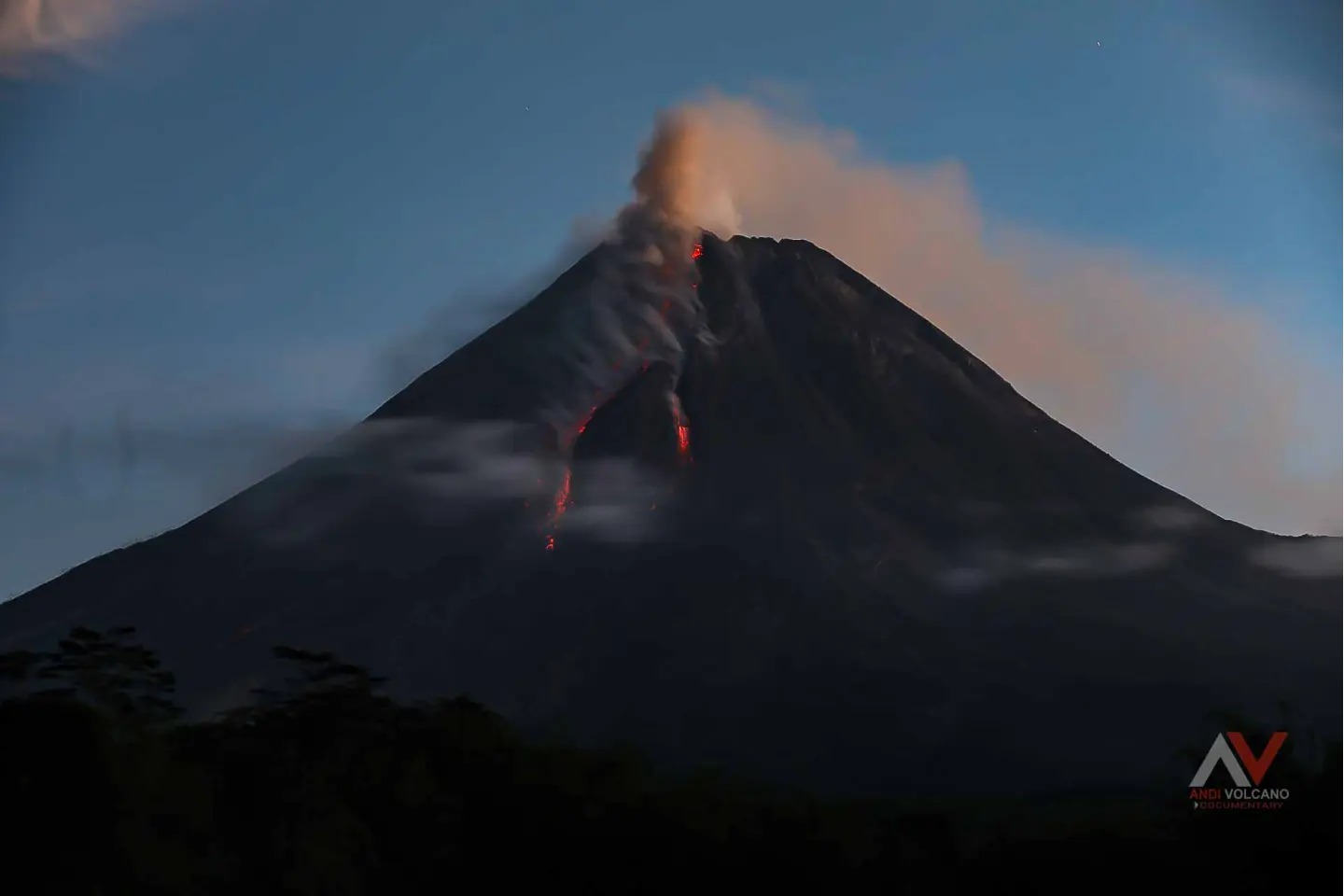
Indonesia , Merapi :
MOUNT MERAPI ACTIVITY REPORT, June 7 – 13, 2024
OBSERVATION RESULT
Visual
The weather around Mount Merapi is generally clear in the morning and night, while it is foggy from noon to evening. White smoke, thin to thick in thickness, low to moderate pressure and with a height of 500 m was observed from the observation post of Mount Merapi Selo on June 8, 2024 at 4:10 p.m. WIB. This week, warm clouds descended twice towards the southwest (upstream of the Bebeng River) to a maximum of 1,000 m. Light ash rain was observed after warm clouds fell on June 8, 2024 at the Mount Merapi observation post in Kaliurang. Lava avalanches were observed 122 times upstream of the Bebeng River over a maximum distance of 1,800 m. The morphology of the Southwest dome was observed to have changed due to dome growth activities, hot cloud avalanches, and lava avalanches. The highest hot spot was observed at 245°C, which was higher than the previous measurement temperature. The morphology of the median dome is relatively constant. The highest hot spot was observed at 217°C, lower than the previous measurement temperature. Based on the analysis of aerial photos, the volume of the southwest dome was measured at 2,265,000 m3 and that of the central dome at 2,362,800 m3.
Seismicity
This week, the seismicity of Mount Merapi recorded:
2 warm cloud avalanche (APG) earthquakes,
32 superficial volcanic earthquakes (VTB),
114 multi-phase (MP) earthquakes,
450 avalanche earthquakes (RF),
6 tectonic earthquakes (TT).
The intensity of earthquakes this week is higher than last week.
Deformation
The deformation of Mount Merapi monitored by EDM this week shows a shortening rate of 0.5 cm/day.
Rain and lahars
This week there was rain at Mount Merapi lookout post with a rain intensity of 19 mm/hour for 45 minutes at Babadan lookout post on June 7, 2024. No additional flow or lahar was reported in the rivers that have their source on Mount Merapi.
Conclusion
Based on the results of visual and instrumental observations, it was concluded that:
Mount Merapi’s volcanic activity is still quite high in the form of effusive eruptive activity. The activity status is set to the “SIAGA” level.
Source : BPPTKG
Photo : Andi Volcanist .