June 10 , 2024.
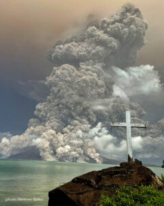
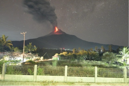
Indonesia , Lewotobi Laki-laki :
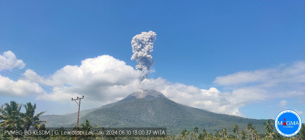
Increased activity level of G. Lewotobi Laki-laki from level II (WASPADA) to level III (SIAGA).
The results of the evaluation of the activities of G. Lewotobi Laki-laki for the period from May 26 to June 9, 2024 are presented below:
I. Visual observation
The volcano is clearly visible until it is covered in fog. The smoke observed from the main crater is white, gray and brown with thin, medium to thick intensity at a height of approximately 100-1000 meters above the summit. An eruption occurred 100-1000 meters above the summit, the ash column from the eruption was white to gray in color. An avalanche occurred, but visually the distance and direction of the slide were not observed. Incandescence was observed on June 9 at 6:43 p.m. WITA when the eruption occurred.
Northeastward lava flows were observed up to approximately 4,340 meters from the main crater of Mount Lewotobi Laki-laki on April 9, 2024 and no significant changes have been observed since February 29, 2024.
II. Instrumental observation
The types of earthquakes recorded during the period from May 26 to June 9, 2024 are:
51 eruption earthquakes,
6 avalanche earthquakes
21 emissions earthquakes,
6 harmonic tremors,
15 low frequency earthquakes,
1 hybrid earthquake,
270 superficial volcanic earthquakes,
146 deep volcanic earthquakes,
14 local tectonic earthquakes,
53 distant tectonic earthquakes.
III. Assessment and recommendations
Visual observations for the period May 26, 2024 to June 9, 2024 of the volcanic activity of Lewotobi Laki-laki show a marked increase in eruptions almost every day, as indicated by the height of the eruptive column averaging 100 to 900 meters above the summit. A Strombolian eruption occurred on June 9, 2024 and incandescence could be observed during the eruption.
Lava avalanches have been recorded during the current period, but visually the lava flow in the northeast direction tends to be stable, without significant movement. Drone measurements on April 9, 2024 showed that the distance of the flow was approximately 4,340 meters from the center of the crater, compared to the previous measurement on February 29, 2024 which reached 4,320 meters showing the movement of the flow was quite slow, this can also be seen in satellite images which show almost no significant change in the lava flows at the northeastern tip. The influence of the slope and the still high temperature of the lava still allow the lava to move, although very slowly.
Earthquakes during this period resulted in a significant increase in the number of eruption earthquakes and volcanic tremors as well as avalanche earthquakes recorded. From the seismic data it can be seen that there is a very significant increase in volcanic tremors, besides the volcanic activity, this is also due to the change of reference station, which previously used the KLT reference station, located at a lower altitude on the slope than the WLR station which now serves as a reference station. Repairs to the WLR station were carried out on April 27, 2024 and the seismicity at the WLR station has a better performance in recording the seismicity of the volcano. Volcanic tremors and surface earthquakes that were not previously recorded at the KLT station can now be recorded using the WLR station, resulting in a significant increase in volcanic tremors at the volcano
Based on the results of visual and instrumental monitoring, it is found that there has been an increase in volcanic activity on Mt. Lewotobi Laki-laki, so the activity level was raised from level II (WASPADA) to level III (SIAGA). ), from June 10, 2024 at 09:00 WITA:
The community around Mount Lewotobi Laki-laki and visitors/tourists do not carry out any activities within a radius of 3 km from the center of the volcano eruption and in the sector of 4 km in the North-North-East direction and from 5 km in the North-East sector.
Source et photos : PVMBG
Iceland , Reykjanes Peninsula:
Lava has now flowed onto the road to Grindavík just north of the Bláalón dykes. In recent days, lava has flowed slowly north and along Sýlingarfell towards Grindavík. This morning the progress accelerated and the lava reached the road at 10:40 a.m.
Work had been underway to fill the breach in the fortification since early this morning and this work was completed before the lava reached the road.
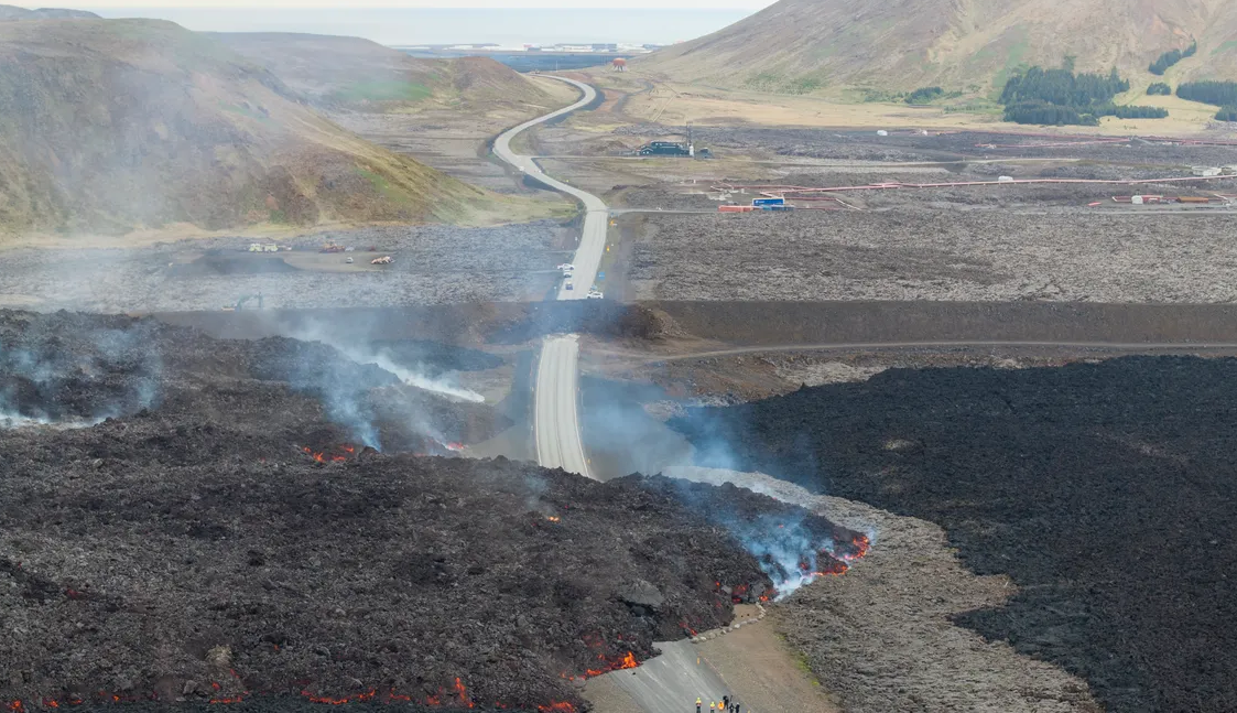
Lava flowed into Grindavíkurveg shortly before 11 a.m. this morning, after the flow from the Sundhnúks crater series suddenly increased. Civil Protection Information Officer Hjördís Guðmundsdóttir says that it was possible to close the gap in the Grindavíkurveg defenses in time this morning.
“Before eight o’clock it became clear that a pond to the north of the crater had collapsed and therefore lava had been emitted north of Sýlingarfell. So it was clear that we had to act and close the defense,” explains Hjördis.
There was no need to evacuate the city, but it was decided to close the Blue Lagoon. Hjördís says firefighters are on site and will be available if chunks of lava breach the defensive wall and ignite vegetation. That’s why efforts are being made to prevent wildfires from becoming more frequent than they have been.
Sources : Vedur , RUV.
Photo : RUV – Ragnar Visage.
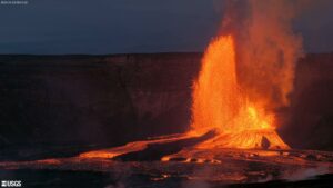
Hawaii , Kilauea :
Sunday, June 9, 2024, 8:47 AM HST (Sunday, June 9, 2024, 18:47 UTC)
19°25’16 » N 155°17’13 » W,
Summit Elevation 4091 ft (1247 m)
Current Volcano Alert Level: ADVISORY
Current Aviation Color Code: YELLOW
Activity Summary:
Kīlauea volcano is not erupting. The eruption that began on Monday, June 3, southwest of Kaluapele (Kīlauea caldera) within Hawai’i Volcanoes National Park has ended. Weak incandescence from the fissure vents was barely visible overnight in webcam images. Volcanic gas emissions at the eruption site have decreased significantly and are approaching background levels. Earthquake counts in the summit region remain elevated, while tremor has dropped to background levels. Inflationary ground deformation of the summit continues. Although the eruption has ended, renewed pulses of seismicity and deformation could result in new eruptive episodes within the area or elsewhere within the summit region.
Eruption Site Observations:
No lava is erupting. Very weak glow from fissures vents continued to be visible in webcam imagery overnight but glow intensity was significantly lower than the previous night. Volcanic gas emissions at the eruption site are approaching background levels (100 tonnes per day or less). Total SO2 emission rates for the summit and eruption site of approximately 400 t/d were measured on June 6. Seismic activity remains low at the eruption site.
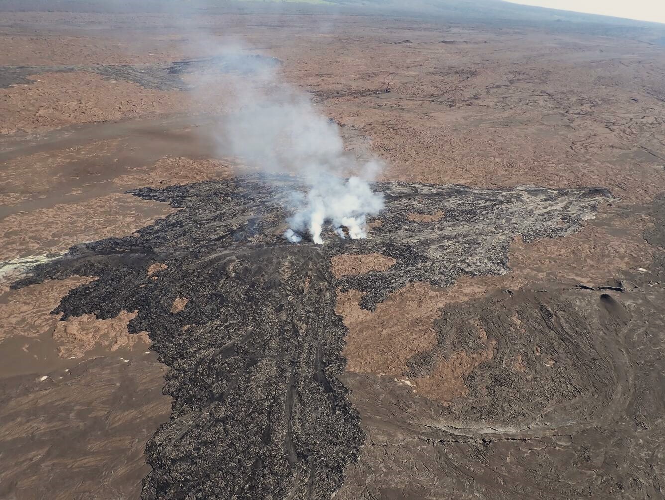
Aerial view of Fissures 3 and 4 of the now-interrupted Kīlauea Southwest Rift Zone eruption that began on June 3, 2024. During a flyby around 8:15 a.m. HST on June 6, 2024, scientists from the The USGS Hawaiian Volcano Observatory observed persistent gas emissions and no active lava.
Summit and Upper Rift Zone Observations:
Rates of seismicity beneath the summit, upper East Rift Zone, and upper Southwest Rift Zone were elevated over the past day. About 60 earthquakes occurred over the past 24 hours. Earthquakes were mostly located beneath the south caldera region and upper East Rift Zone, at depths of 1.5-3 km (1–1.8 miles), with magnitudes under M2.5. Tremor has decreased to background levels across the summit region. Inflationary ground deformation of the summit continued over the past day. The Uēkahuna tiltmeter northwest of the summit recorded overall inflation of approximately 1.5 microradian over the past 24 hours. The Sand Hill tiltmeter southwest of the summit recorded approximately 5 microradians of inflation over the past 24 hours.
Lower Rift Zone Observations:
Rates of seismicity and ground deformation beneath the middle and lower East Rift Zone and lower Southwest Rift Zone are low. Eruptive activity and unrest have been restricted to the summit and upper rift zone regions. Measurements from continuous gas monitoring stations downwind of Puʻuʻōʻō in the middle East Rift Zone remain below detection limits for SO2, indicating that SO2 emissions from Puʻuʻōʻō are negligible.
Source : HVO
Photo : USGS / A.R. Nalesnik.
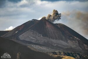
Ecuador , Reventador :
DAILY REPORT ON THE STATE OF THE REVENTADOR VOLCANO, Sunday June 9, 2024.
Information Geophysical Institute – EPN.
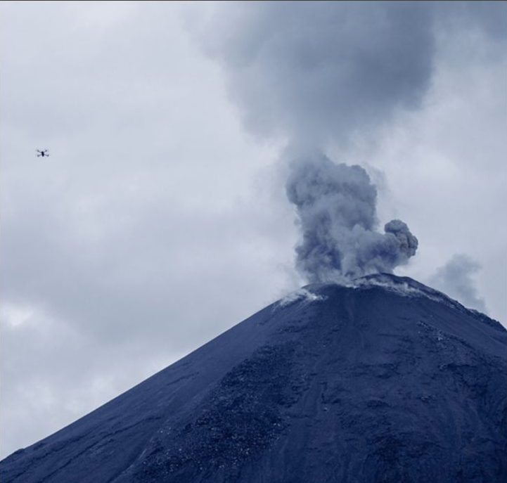
Surface activity level: High, Surface trend: No changes
Internal activity level: Moderate, Internal trend: No changes
Seismicity: From June 8, 2024, 11:00 a.m. to June 9, 2024, 11:00 a.m.:
Below is the count of seismic events recorded at the reference station
Explosion (EXP) 74
Long Period (LP) 15
Transmitting tremor (TREMI) 5
Harmonic Tremor (TRARM) 4
Precipitation/Lahars:
No rain was reported in the area. **In the event of heavy rains, these could remobilize the accumulated materials, generating flows of mud and debris which would flow down the sides of the volcano and flow into adjacent rivers.
Emissions/ash column:
No gas or ash emissions were observed by surveillance cameras or satellite images. No report has been published by the WashingtonVAAC agency either.
Other monitoring parameters:
The MIROVA-VIIRS satellite system recorded 1 thermal anomaly, while the FIRMS satellite system recorded 4 thermal anomalies.
Observation:
The volcano remained cloudy most of the time. At the end of this report, the volcano remains cloudy.
Alert Level: Orange
Source et photo : IGEPN.
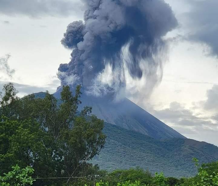
Nicaragua , San Cristobal :
“The San Cristóbal volcano recorded landslides on the inner walls of the crater,” explains Ofena.
Agustín Moreira, director of the Ofena Natural Phenomena Observatory, spoke of the low-intensity explosions and the expulsion of gas and ash, which the San Cristóbal volcano recorded Friday afternoon in the Chinandega department.
Moreira considers that the recent activity is linked to landslides in the crater of the volcano, the highest in Nicaragua, at 1,745 meters above sea level.
« Because of the rain, walls collapse inside the crater which is the throat of the volcano, the crater blocks and then the pressure inside the volcano increases and suddenly, with the explosions, it releases materials such as gas and ash,” commented Agustín. Moreira.
The director of Ofena added that for this reason the emanations of gases such as sulfur respond to a normal degassing process « the combination of the quantities of water that precipitated very close to the volcano, so these types of explosions are natural, to free the crater with its processes,” said the agro-meteorologist.
Moreira urged the population not to worry « although it is true that volcanic materials fall near the volcano, but this has always been a characteristic of these volcanoes », he commented on the matter.
Source et photo : 100% Noticias.