December 08 , 2022.
Italy , Stromboli :
Statement on Stromboli activity, 07 December 2022, 13:11 (12:11 UTC).
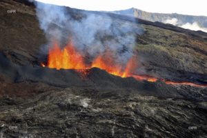
The National Institute of Geophysics and Volcanology, Osservatorio Etneo, communicates that today the personnel of the INGV-OE of Catania carried out an aerial flight over Stromboli thanks to the helicopter made available by the 2nd squadron of the Guardia Costiera. The observations allowed us to have a distinct view of the crater terrace and the lava field along the Sciara. Thermal images did not detect explosive activity in the crater area during the flyby. Regarding the lava flow, it continues to be active in the upper part of the Sciara del Fuoco, the lava front is located at an altitude of about 600 m above sea level.
From a seismic point of view, during the last 24 hours, the average amplitude of the volcanic tremor has shown no variation, always remaining, so far, within the range of average values.
Since the last press release published, the signals from the ground deformation monitoring networks (GNSS and tilt) have not shown any significant variations.
Further updates will be communicated soon.
Source : INGV.
Photo : Stromboli stati d’animo
Hawaii , Mauna Loa :
Wednesday, December 7, 2022, 4:23 PM HST (Thursday, December 8, 2022, 02:23 UTC)
19°28’30 » N 155°36’29 » W,
Summit Elevation 13681 ft (4170 m)
Current Volcano Alert Level: WARNING
Current Aviation Color Code: ORANGE
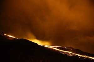
The Northeast Rift Zone eruption of Mauna Loa continues. One active fissure, fissure 3, is feeding a lava flow downslope.
Fissure 3 is generating a lava flow traveling to the north toward Saddle Road that has reached relatively flatter ground and slowed down significantly, as expected.
The lava flow has advanced very little since 6:00 a.m. this morning, December 7, when it was about 1.8 mi (2.9 km) from Saddle Road. The flow advance has slowed possibly due to a significant breakout removing lava from the channel about 2.8 mi (4.5 km) behind the tip of the main flow on the east side. The main flow has advanced at an average rate slower than 20 feet (6 meters) per hour during the 24-hour period prior to this morning. The lava flow remains active and is continuously supplied from the fissure 3 vent.
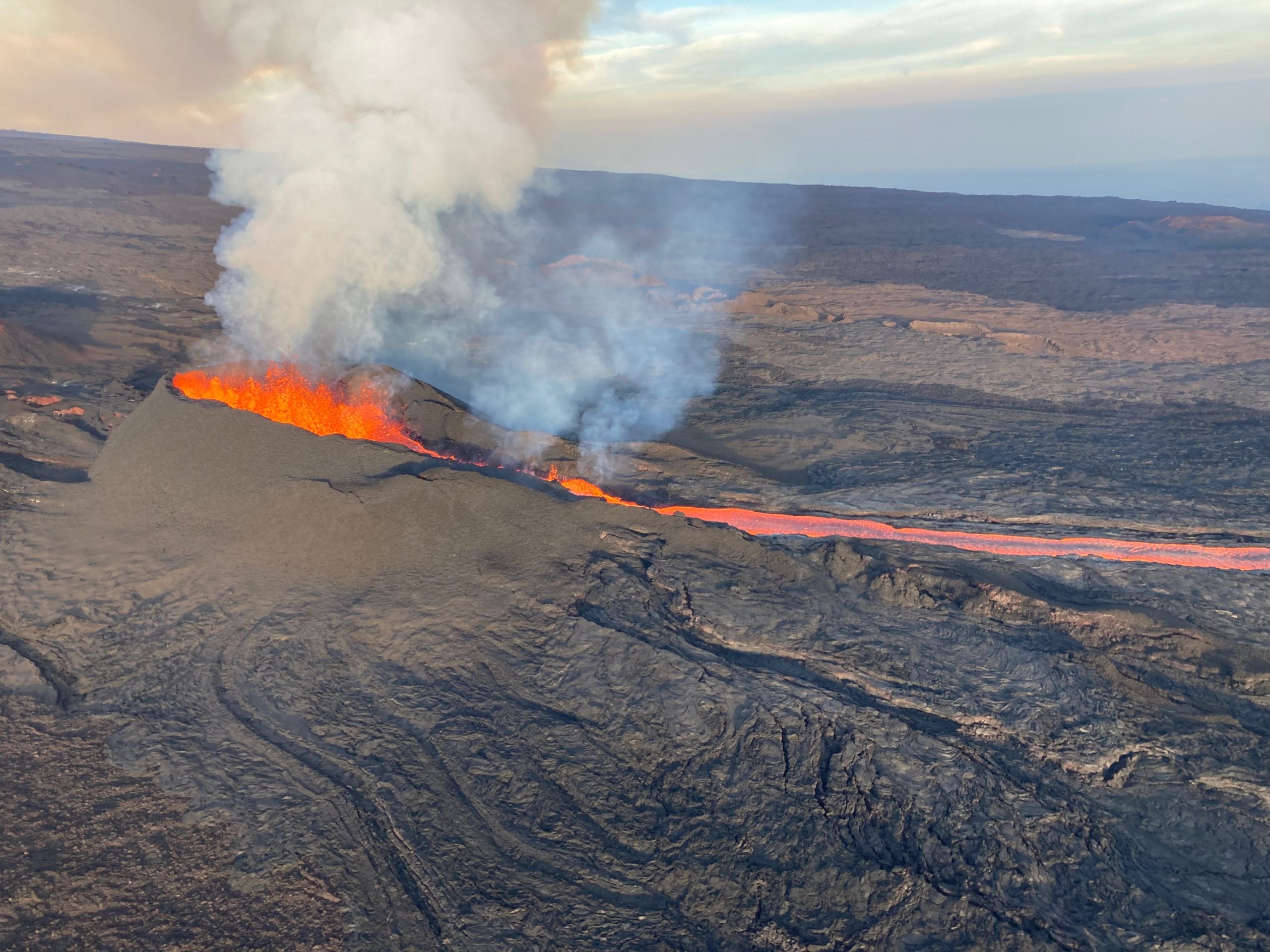
A morning overflight on December 7, 2022, provided aerial views of fissure 3 erupting on the Northeast Rift Zone of Mauna Loa.
Sulfur dioxide (SO2) emission rates of approximately 120,000 tonnes per day (t/d) were measured on December 4, 2022, and remain elevated at this time. Volcanic gas is rising high and vertically into the atmosphere before being blown to the west at high altitude, generating vog (volcanic air pollution) in areas downwind.
Pele’s hair (strands of volcanic glass) fragments are being wafted great distances and have been reported as far Honoka‘a.
Tremor ( signal associated with subsurface fluid movement) continues beneath the currently active fissure. This indicates that magma is still being supplied to the fissure, and activity is likely to continue as long as we see this signal.
There is no active lava within Moku’āweoweo caldera nor the Southwest Rift zone
Source : HVO.
Photo : USGS/ M. Patrick.
Indonesia , Semeru :
VOLCANO OBSERVATORY NOTICE FOR AVIATION – VONA
Issued : December 07 , 2022
Volcano : Semeru (263300)
Current Aviation Colour Code : ORANGE
Previous Aviation Colour Code : orange
Source : Semeru Volcano Observatory
Notice Number : 2022SMR717
Volcano Location : S 08 deg 06 min 29 sec E 112 deg 55 min 12 sec
Area : East java, Indonesia
Summit Elevation : 11763 FT (3676 M)
Volcanic Activity Summary :
Eruption with volcanic ash cloud at 22h36 UTC (05h36 local).
Volcanic Cloud Height :
Best estimate of ash-cloud top is around 13043 FT (4076 M) above sea level or 1280 FT (400 M) above summit. May be higher than what can be observed clearly. Source of height data: ground observer.
Other Volcanic Cloud Information :
Ash cloud moving to north. Volcanic ash is observed to be gray. The intensity of volcanic ash is observed from medium to thick.
Remarks :
Eruption recorded on seismogram with maximum amplitude 23 mm and maximum duration 78 second.
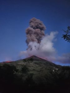
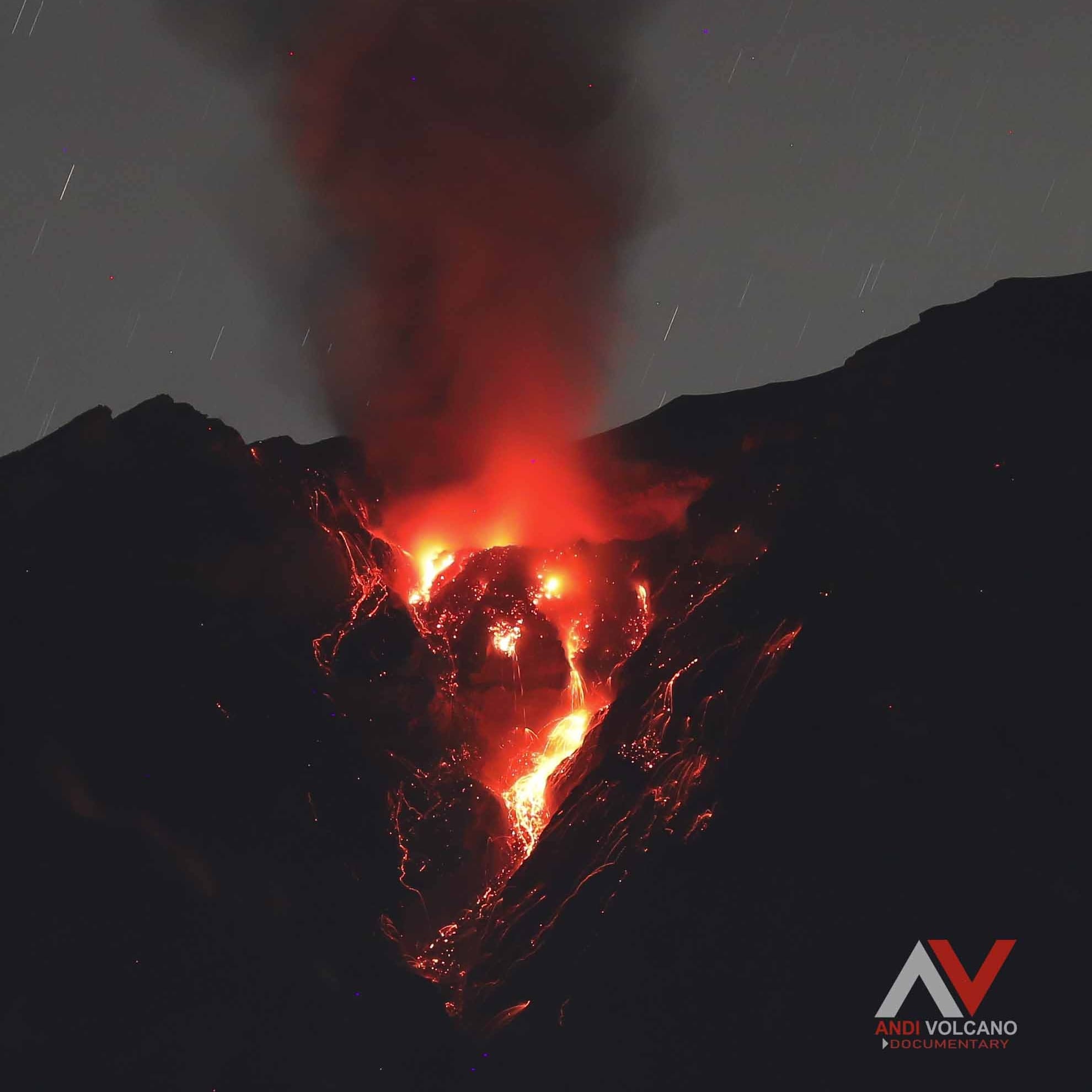
PVMBG reported that the eruption at Semeru was ongoing the past month, culminating in a collapse of lava causing notable pyroclastic flows and ash plumes on 4 December. During 1 November-2 December an average of 88 daily white-and-gray ash plumes of variable densities were visually observed rising as high as 1.5 km above the summit. Pyroclastic flows, seen twice, traveled as far as 4.5 km down the flank. Deformation data showed inflation and thermal anomalies indicated hot lava-dome material at the summit. A white-to-gray ash plume rose around 500 m above the summit and drifted S on 3 December.
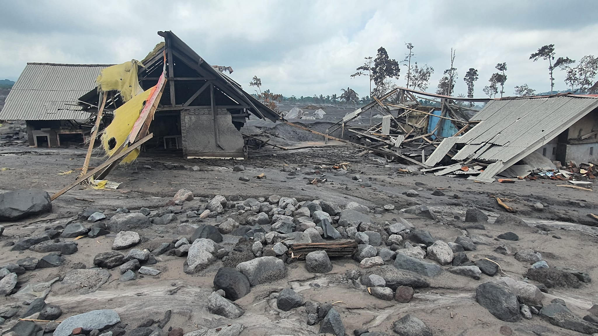
At 02h46 on 4 December material collapsed on the SE flank, producing a series of pyroclastic flows that mainly traveled 5-13 km SE and S, and as far as 19 km in those same directions, according to BNPB. The pyroclastic flows overtook the Gladak Perak Bridge, 13 km SE of the summit, which connected residents of Pronojiwo (13 km SE) and Lumajang (32 km ESE) and appeared to be under construction based on pictures posted on social media. Dense dark-gray ash plumes rose along the pyroclastic flows up to 1.5 km above the summit and drifted SE and S. The ash plumes caused dark conditions and limited visibility, especially in Kajar Kuning (12 km SE) where residents reported dense ashfall and heavy rain. Ejected incandescent material was deposited as far as 8 km from the summit, and ashfall was reported in areas 12 km SE. Pyroclastic flows were ongoing at least through 09h51, traveling 5-7 km down the flanks. At 12h00 PVMBG raised the Alert Level to 4 (the highest level on a scale of 1-4) and warned the public to stay at least 8 km away from the summit, and 500 m from Kobokan drainages within 17 km of the summit, along with other drainages originating on Semeru, including the Bang, Kembar, and Sat, due to lahar, avalanche, and pyroclastic flow hazards. A total of 1,979 people were evacuated to 11 centers, a public kitchen was established, and thousands of masks were distributed to minimize respiratory health risks due to volcanic ash.
Sources : Magma Indonésie , GVP.
Photos : Andi Volcanist.
Chile , Hudson :
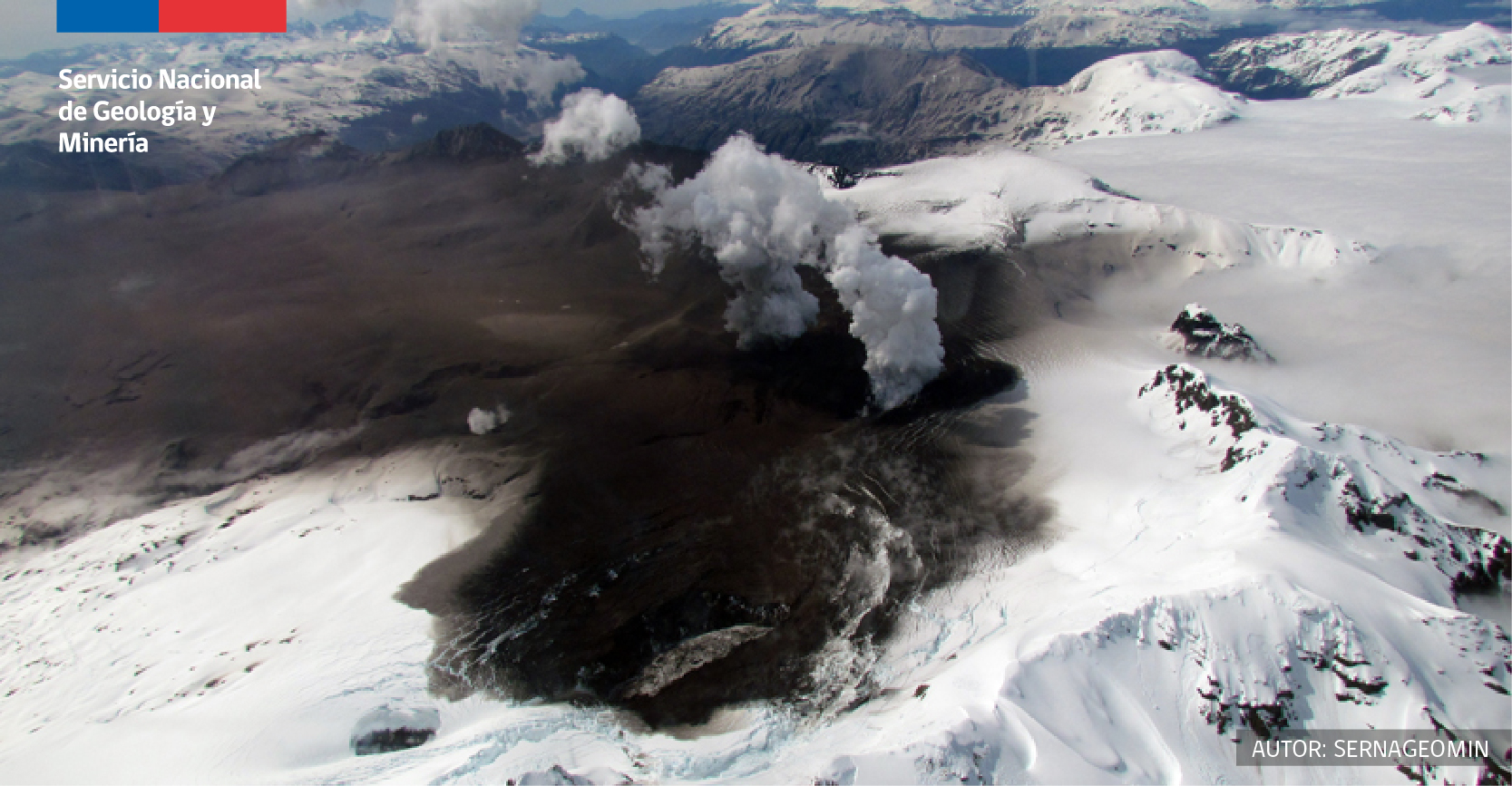
Special Report on Volcanic Activity (REAV), Aysen Del General Carlos Ibanez Del Campo area, Hudson volcano, December 06, 2022, 06:10 a.m. local time (mainland Chile).
The National Service of Geology and Mines of Chile (Sernageomin) publishes the following PRELIMINARY information, obtained through the monitoring equipment of the National Volcanic Monitoring Network (RNVV), processed and analyzed at the Volcanological Observatory of the Southern Andes ( Ovdas):
On Tuesday November 6, 2022, at 05:53 local time (08:53 UTC), the monitoring stations installed near the Hudson volcano recorded an earthquake associated with both rock fracturing (volcano-tectonic type) and fluid dynamics in the volcanic system (hybrid type).
The characteristics of earthquakes after their analysis are as follows:
ORIGINAL TIME: 05:53 local time (08:53 UTC)
LATITUDE: 45.938°S
LONGITUDE: 72.930°E
DEPTH: 6.7 km
REDUCED TRAVEL: 559.5 (cm*cm)
LOCAL MAGNITUDE: 2.7 (ML)
COMMENTS:
Following the event, 3 hybrid-type earthquakes of lower energy were recorded
The volcanic technical alert remains at the Green level.
Sources : Sernageomin.
Photo : Sernageomin
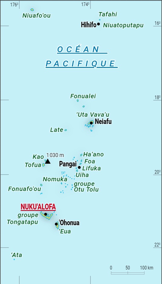
Tonga Archipelago , Late Island :
On 29 November Tonga Geological Services reported results from a recent visit to Late. The observers noted warmed ground surfaces, steam rising from fresh cracks, and vents at the summit. The features were too small to be identified in satellite images processed by VOLCAT (Volcanic Cloud Analysis Toolkit) software. They concluded that the features were the result of low-temperature hydrothermal activity driven by a shallow magma body at depth, and that the cracks were the result of past volcanic activity. There were no risks to local communities and mariners were advised to report any observable changes to the island. The Alert Levels all remained at Green (the lowest level on a four-color scale) for mariners, residents, and the aviation community.
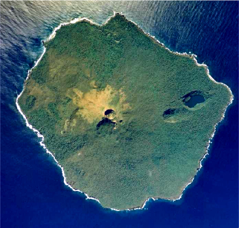
An aerial photo of Late taken in July 1990 shows the main summit crater breached to the SE and a NE graben occupied by large pit craters, the largest of which contains a saltwater lake. Except for remnants of a small lava plug in the summit crater, no fresh lava flows are present. The small, 6-km-wide island rises 1,500 m from the sea floor, with its conical summit reaching more than 500 m above sea level.
The small, 6-km-wide circular island of Late, lying along the Tofua volcanic arc about 55 km WSW of the island of Vavau, contains a 400-m-wide, 150-m-deep summit crater with an ephemeral lake. The largely submerged basaltic-andesite to andesitic volcano rises 1500 m from the sea floor, with its conical summit reaching 540 m above sea level.
Cinder cones are found north of the summit crater, west and north of a semicircular plateau 100-150 m below the summit, and on the NW coast. A graben-like structure on the NE flank contains two large pit craters, the lower of which is partially filled by a saltwater lake. Only two eruptions have occurred in historical time, both from NE-flank craters, which produced explosive activity and possible lava flows in 1790 and 1854.
Source : Tonga Geological Services, Government of Tonga , GVP.
Photo : Tonga Ministry of Lands, Surveys and Natural Resources, 1990 (published in Taylor and Ewart, 1997). Universalis .