April 03 , 2020 .
Indonesia , Mérapi :
VOLCANO OBSERVATORY NOTICE FOR AVIATION – VONA.
Issued: April 02 , 2020 .
Volcano: Merapi (263250)
Current Aviation Colour Code: ORANGE
Previous Aviation Colour Code: orange
Source: Merapi Volcano Observatory
Notice Number: 2020MER11
Volcano Location: S 07 deg 32 min 31 sec E 110 deg 26 min 31 sec
Area: Special Region of Yogyakarta, Indonesia
Summit Elevation: 9498 FT (2968 M)
Volcanic Activity Summary:
Eruption with volcanic ash cloud at 08h10 (15h10 UT).
Volcanic Cloud Height:
Best estimate of ash-cloud top is around 19098 FT (5968 M) above sea level, may be higher than what can be observed clearly. Source of height data: ground observer.
Other Volcanic Cloud Information:
Ash cloud moving to East.
Remarks:
Eruption recorded on the seismogram with amplitude max 78 mm and 345 second duration. Eruption has stopped.
Source : Magma Indonésie ,
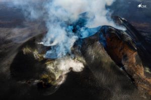
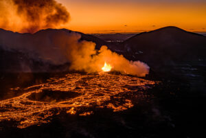
La Réunion , Piton de la Fournaise :
Going on alert 2-2 eruption in progress in the Enclos .
Following the seismic crisis this morning, between 8:15 am and 8:51 am local time, and after a lull of more than 3 hours, a volcanic tremor, synonymous with the arrival of magma near the surface, has been recorded since approximately 12:20 local time. According to OVPF records, the source of this tremor is located on the eastern flank, inside the Enclos . No visual confirmation of the start of an eruption could be made at this time and we cannot confirm the arrival of the lava on the surface. However, the presence of a tremor shows the emission of hot and incandescent gases on the surface, and the possibility of lava emission.
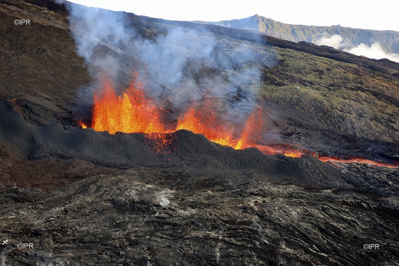
Under these conditions, the Prefect decided to implement the 2-2 alert phase « eruption in progress in the Enclos Fouqué » of the specific ORSEC * volcano device this Thursday, April 2, 2020 at 1 p.m.
Aline Peltier, director of the Piton de la Fournaise Volcanological Observatory (OVPF) speaks live on Antenne Réunion.
« Following the seismic crisis this morning which lasted just over 30 minutes, we had not recorded any earthquake and we no longer had in mind to have such an imminent eruption. At 12:30 pm the surprise with the appearance of the tremor. «
« A fairly unusual case »
« This scenario with a propagation without seismicity is not very common at the level of Piton de la Fournaise. Usually, when the magma propagates laterally after a seismic crisis, we manage to follow it thanks to seismicity. « we did not have this seismicity due to an environment already weakened by the eruption of February 2020 and the eruptions of 2019 which took place on the same flank. »
Source : OVPF
United – States , Yellowstone :
44°25’48 » N 110°40’12 » W,
Summit Elevation 9203 ft (2805 m)
Current Volcano Alert Level: NORMAL
Current Aviation Color Code: GREEN
Recent work and news
It’s been an eventful month for seismic activity in the western USA, with a M5.7 earthquake near Salt Lake City, Utah, on March 18, and a M6.5 in central Idaho on March 31. These earthquakes are caused by tectonic extension of the region and are not related to Yellowstone, nor will they have a significant impact on the Yellowstone system. Some strong earthquakes in the region, like the 1983 M6.9 Borah Peak, ID, and 1959 M7.3 Hebgen Lake, MT, earthquakes, have impacted geyser behavior, but that is due to the response of the shallow and fragile geyser conduits to shaking. It is not yet clear if the M6.5 in central Idaho will have a similar impact; observations of geyser activity over the coming days to weeks will answer that question.

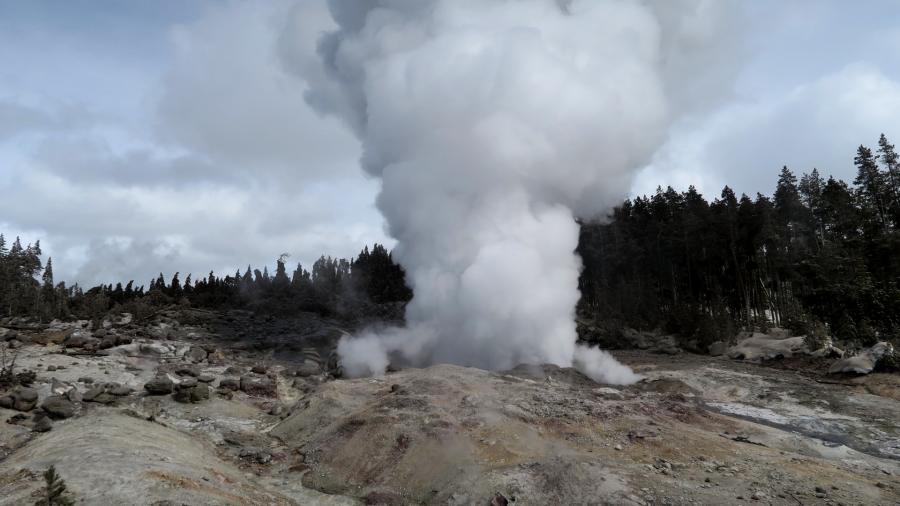
Steamboat geyser, in Norris Geyser Basin, experienced three water eruptions in the past month, on March 6, 15, and 25, bringing the total number of eruptions for the year to nine.
Seismicity
During March 2020, the University of Utah Seismograph Stations, responsible for the operation and analysis of the Yellowstone Seismic Network, located 111 earthquakes in the Yellowstone National Park region. The largest event was a minor earthquake of magnitude 3.1 located 5 miles north-northwest of West Yellowstone, MT, on March 31 at 9:36 AM MDT.
The monthly seismicity in Yellowstone included two earthquake swarms:
1) The largest earthquake swarm occurred about 7 miles east-northeast of West Yellowstone, MT, during March 21-29 and included 19 earthquakes ranging in magnitude from 0.0 to 2.1. The largest swarm event occurred on March 28 at 10:11 PM MDT.
2) A swarm of 15 earthquakes ranging in magnitude from 0.1 to 1.7 occurred about 9 miles east of West Yellowstone, MT, during March 5-14. The largest swarm event occurred on March 12 at 2:51 AM MDT.
Earthquake sequences like these are common and account for roughly 50% of the total seismicity in the Yellowstone region.
Yellowstone earthquake activity remains at background levels.
Ground deformation
The overall deformation style and rate at Yellowstone remains unchanged since the last update. Subsidence of Yellowstone caldera, which has been ongoing since 2015, continues at an average rate of 2-3 cm (about 1 in) per year with minor fluctuations related to seasonal changes. In the area of Norris Geyser Basin, GPS data indicated the start of subsidence in September 2019, accumulating about 3 cm (a little over 1 in) of subsidence to the end of the year. That subsidence paused in early 2020, and no significant changes at Norris have been recorded since the start of the year.
Source : YVO .
Photos : Daisy Geyser /national park , Steamboat geyser / Behnaz Hosseini.
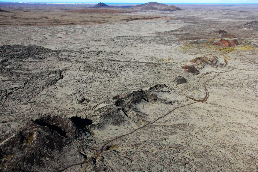
Iceland , Reykjanes Peninsula :
More research is needed to decipher the on-going activity at the Reykjanes Peninsula as a whole
From the beginning of 2020, over 6000 earthquakes have been manually checked on the Reykjanes peninsula.
On Thursday the 26th of March an on-line Scientific Advisory Board meeting was held to discuss the ongoing unrest in the Reykjanes peninsula. Scientists from IMO, University of Iceland, ISOR and representatives from Civil Protection, HS-Orka, ISAVIA-ANS, and the Environment Agency of Iceland attended the meeting.
Magmatic intrusion still the most likely explanation for the ongoing earthquake activity north of Grindavík

Recent data show that uplift has started again, with the center just west of Mt. Thorbjorn. Uplift was measured from 22. January 2020 until beginning of February and has started up again during the first half of March. During the first sequence in January-February, the deformation rate was about 3-4 mm per day with a total of a 6 cm uplift during the whole period. In the sequence that is ongoing now, the deformation rate looks to be only half of what it was (or even slower). In total the uplift is about 7-8 cm since the end of January. The Scientific Advisory Board still believes that the most likely explanation of the uplift is a magma intrusion where the magma is “forcing” its way horizontally between the stratum in the crust and forming a thin sill at about 3 to 4 km depth. The magma intrusion causes considerable amount of earthquakes in the area north of Grindavík.
The people of Grindavík have not missed out on the earthquake activity. On the 19th of March, a shallow earthquake swarm was measured in the vicinity to an injection borehole in Svartsengi, only 3 km north the edge of the town. A model of the ongoing magma intrusion shows that fissures can open in the uppermost layer of the crust, at 1-2 km, because of the tensional stress induced by the uplift itself. This change in the crustal stress might lead to more earthquakes related to injection at boreholes, which was not common before in the area. The work procedure for the injections will be reviewed in collaboration with HS-Orka and discussion will be taken on how is the best way to monitor the earthquakes likely due to these changes.
It is important to monitor and investigate the ongoing activity in the Reykjanes peninsula as a whole.
During the meeting it was reported that from the beginning of 2020, over 6000 earthquakes have been manually checked in the Reykjanes peninsula. This is the most intense activity ever recorded in the region since the beginning of digital monitoring in 1991. On Saturday the 28th of March, and earthquake swarm occurred in Eldey, indicating that the activity is affecting all volcanic systems in the peninsula and the ridge, i.e from Eldey all the way to Krýsuvík. The interpretation of these events is still uncertain, but there are indications that a common underlying process is the cause of the activation of such a widespread area in such a short timeframe. However, the Reykjanes peninsula and the Reykjanes ridge are composed of plate boundaries were also, the Eldey, Reykjanes, Svartsengi and Krýsuvík volcanic systems lie right across the boundaries. Because of the activity ongoing in the area, the SAB believes that it is extremely important to monitor and investigate the ongoing activity in the Reykjanes peninsula as a whole, and compare this activity with older events in the area to try to decipher the reasons and identify possible developments.
Source : IMO.
Photos : IMO , Ómar Ragnarsson.