June 8 , 2024.
Iceland : Reykjanes Peninsula :
Volcanic eruption activity has remained fairly constant in recent days. The earth stopped sinking in Svartsengi
Updated June 7 at 3:20 p.m.
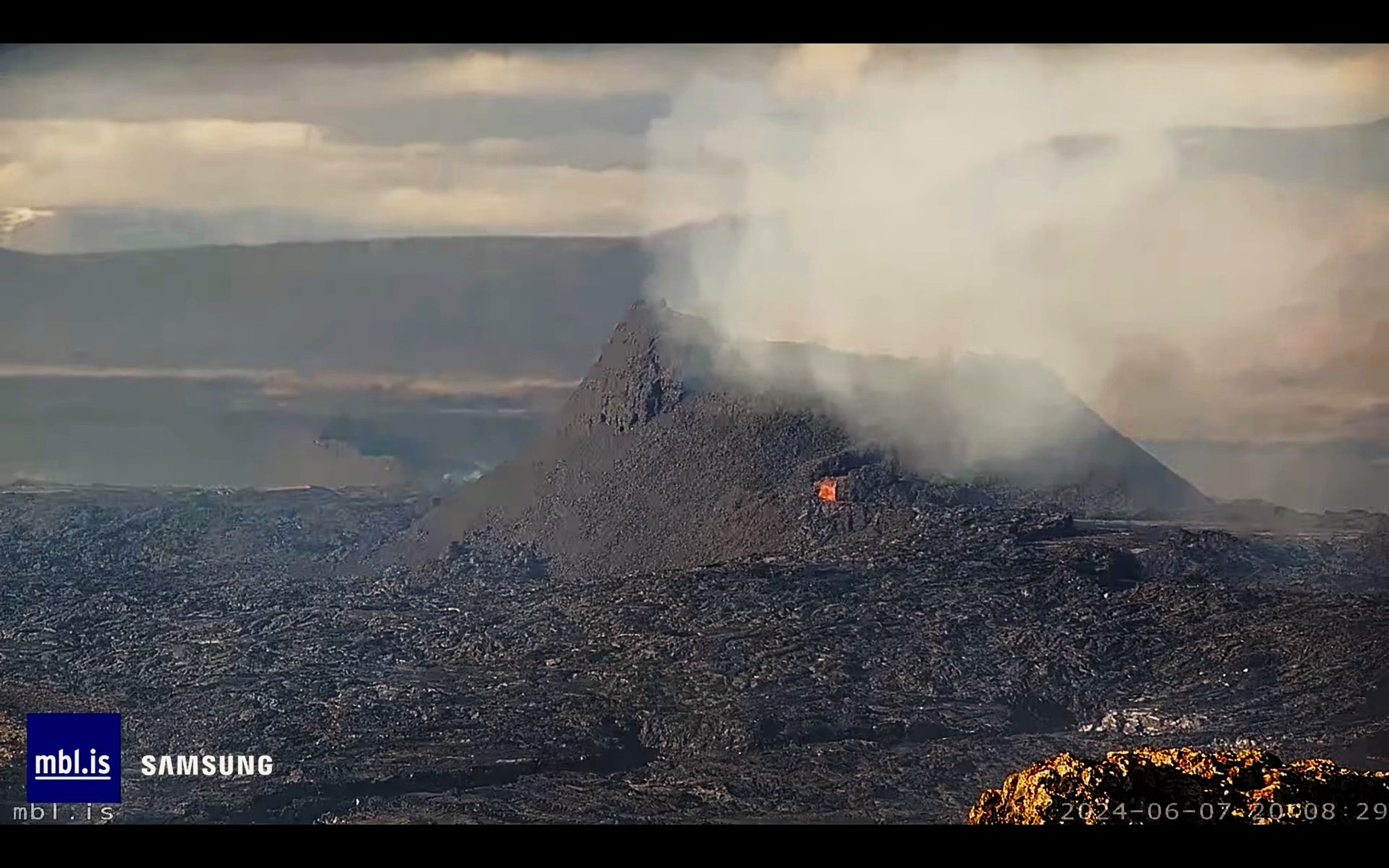
Continuous activity in a crater that remains fairly constant
The lava flows mainly towards the North-West
The earth stopped sinking in Svartsengi
Updated risk assessment. Gas pollution could be observed in Grindavík
The eruption of the Sundhnúks crater series continues and has now been nine days since it began. Since Tuesday June 4, only one crater was active. The lava flows mainly northwest towards Sýlingarfell, where the lava bed thickens, but from there there are active lava flows north of Sýlingarfell.
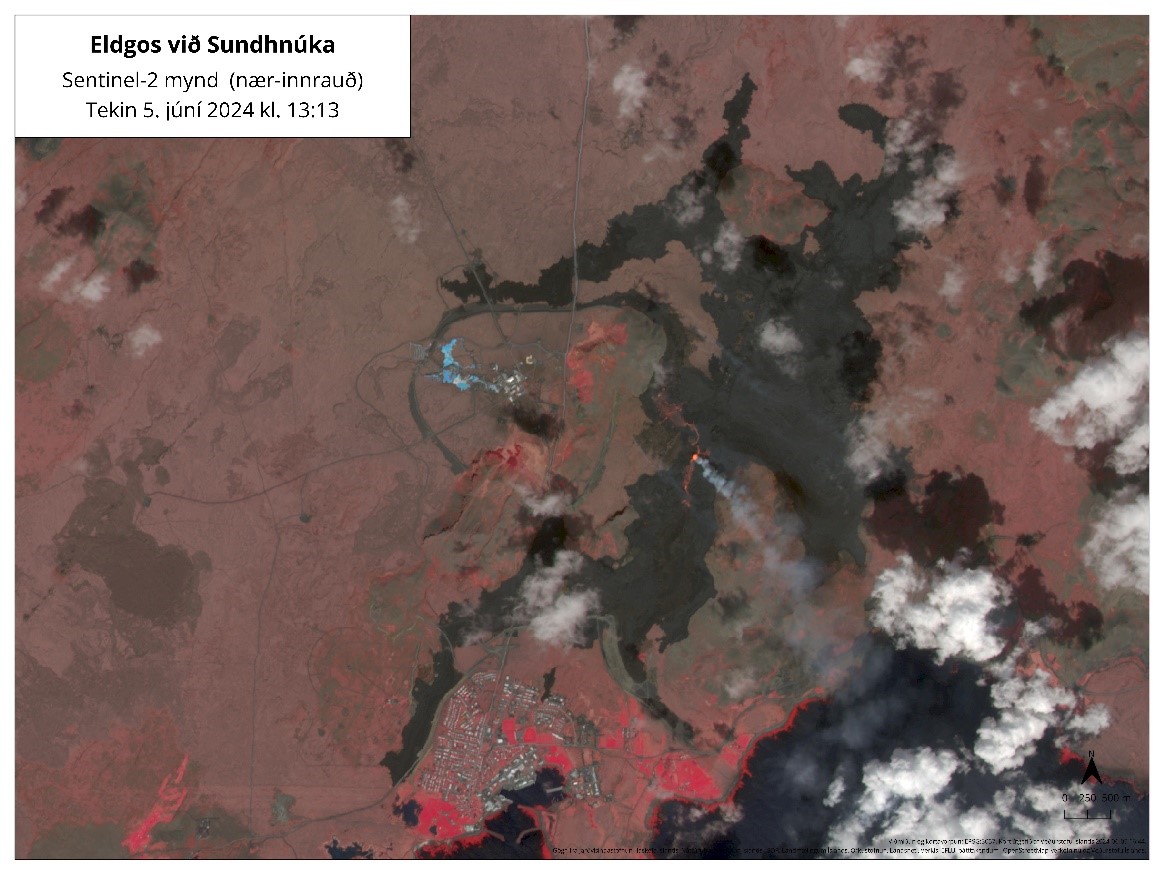
Satellite image from June 5 showing the Svartsengi and Grindavík lava bed. In the photo you can also see the crater and the lava flowing from it northwest to Sýlingarfell and south to Hagafell. The image is a so-called “near infrared” image where vegetation and other photosynthetic organisms appear in different reds. This representation is also suitable for distinguishing new lavas from much older lavas and areas that have been prey to forest fires.
The imaging team from the National Institute of Natural History and Surveying processed data collected by experts from Efla, Verkís and Svarma during a drone flight over the eruption centers on June 3. The data shows that the area of the lava bed has increased to 8.6 km2 and its volume is about 36 million m3.
Based on these measurements, the average lava flow from the afternoon eruption of May 29 to June 3 is estimated at approximately 30 m3/s. These results are based on data covering approximately 70% of the lava width, but it is assumed that there was no significant change in lava width outside of this area between measurements. After these measurements, the change in eruption activity resulted in a decrease in the number of active craters, and one crater has been active since June 4. There have been no measurements of lava flows since then, but for comparison, the lava flow from the last eruption of the Sundhnúks crater series was estimated at 3-4 m3/s when a crater was active.
The earth stopped sinking in Svartsengi
In the first days after the eruption, ground subsidence was measured in the Svartsengi region, which indicated that more magma flowed from the magma accumulation zone to the surface than flowed into it. from the depths. Deformation measurements taken in recent days show that land subsidence appears to have stopped, and it is therefore likely that the flow of magma from the depths towards the magma accumulation zone is now comparable to that found on the surface in the Sundhnúks crater series.
Monitoring possible changes in magma accumulation beneath Svartsengi
As mentioned in the last update, this was the first time since volcanic activity began in the Sundhnúks crater series in December 2023 that subsidence was measured at Svartsengi during an eruption. Yesterday, the University’s Institute of Geosciences released the first rock and geochemical data from the ongoing eruption. The data show that the chemical composition of the magma now rising to the surface is no different from that which appeared during the last four volcanic eruptions of the Sundhnúks crater series, but is similar to that of the magma from the beginning of the Geldingaðalur eruption in 2021. These results are a sign that the magma collection area beneath Svartsengi is changing. At the moment it is not possible to assess exactly what kind of changes are taking place, but in the near future more data will be collected and analyzed to try to shed light on them.
Source : IMO.
Photos : IMO , MBL . IS
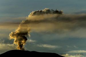
Colombia , Nevado del Ruiz :
Weekly activity bulletin: Nevado del Ruiz Volcano
Regarding the monitoring of the activity of the NEVADO DEL RUIZ VOLCANO, the COLOMBIAN GEOLOGICAL SERVICE (SGC), an entity attached to the MINISTRY OF MINES AND ENERGY, reports that:
In the week of May 28 to June 3, 2024, the volcano continued with unstable behavior. Compared to the previous week, the main variations in the parameters monitored were:
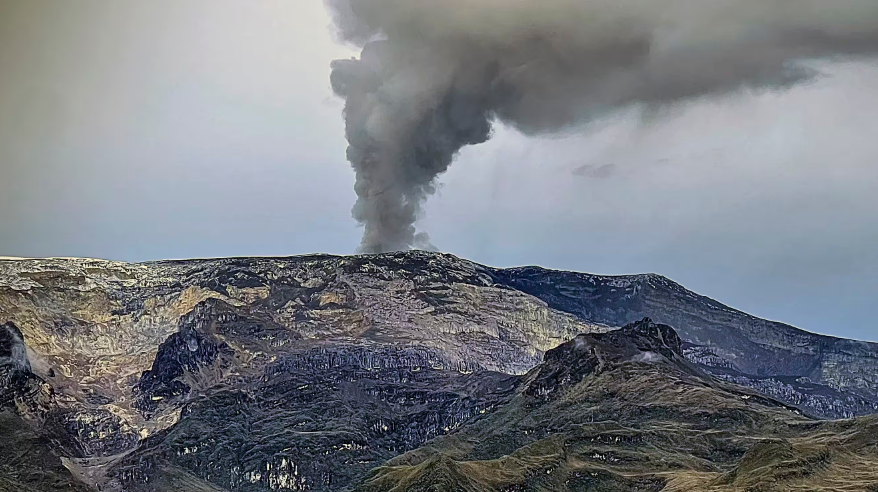
– Seismicity linked to fluid dynamics inside volcanic conduits has decreased in the number of earthquakes recorded and in the seismic energy released. Long-period signals associated with continued ash emission were less recurrent and had low and lower energy levels than those recorded the previous week. Recording of seismic signals associated with pulsatile emissions of ash and gas into the atmosphere with varying energy levels between low and moderate continued. Thanks to photographic cameras used to monitor the volcano and occasional reports from Los Nevados National Natural Park staff in the volcanic area, several ash emissions associated with some of these signals have been confirmed. Confirmation of this phenomenon has been limited due to the heavy cloudiness that continues to be observed in the region.
– Seismic activity associated with the fracturing of rocks within the volcanic edifice has decreased in the number of earthquakes recorded and has maintained similar levels in seismic energy released.
The earthquakes were located in the Arenas crater and, mainly, on the East-Northeast, East-Southeast, North and North-East flanks, at distances less than 8 km from the crater. The depths of the events varied between less than 1 and 8 km from the volcano summit. The highest magnitude of the week was 1.3, corresponding to the earthquake recorded on May 30 at 10:31 p.m., located approximately 4 km north of the crater, 5 km deep. In addition, seismicity linked to the activity of the lava dome (protuberance or mound) located at the bottom of the crater was recorded. This seismicity was of short duration and low energy level.
– On the volcano, the emission of water vapor and gas into the atmosphere from the Arenas crater continues.
Sulfur dioxide (SO₂) outgassing rates were variable and showed a decrease.
The maximum height of the gas column, estimated above the summit of the volcano, was 900 m vertically, on June 2, and 1,800 m dispersed, on June 1st. The direction of dispersion of the gas column during the week was variable with a preferential trend towards the northwest flank of the volcano.On June 1, a report of ash fall was received from the Valley of the Tombs area in the Nevados National Natural Park, associated with the ash emission of the signal recorded at 02:23.
– When monitoring surface activity from satellite monitoring platforms, the detection of thermal anomalies at the bottom of Arenas Crater continued to be limited by the heavy cloudiness conditions in the area. The anomalies detected were few in number and their energy levels were low to moderate. On June 1, it should be noted that there was again a good observation of the thermal anomaly which had not been observed since April.
Source : SGC
Photo : COLOMBIAN AIR FORCE
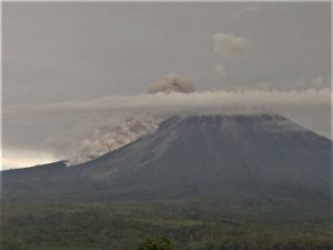
Indonesia , Merapi :
MONT MERAPI ACTIVITY REPORT May 31 – June 6, 2024, Published on June 7, 2024
OBSERVATION RESULT
Visual
The weather around Mount Merapi is generally clear in the morning and night, while it is foggy from noon to evening. White smoke, fine to thick, low to moderate pressure and 300 m high was observed from the observation post on Mount Merapi Selo on June 6, 2024 at 09:40 WIB. This week, warm clouds descended 3 times towards the South-West (upstream of the Bebeng River) up to a maximum of 1,000 m. Lava avalanches were observed 141 times upstream of the Bebeng River over a maximum distance of 1,800 m. The morphology of the southwest dome was observed to have changed due to dome growth activities, hot cloud avalanches, and lava avalanches.
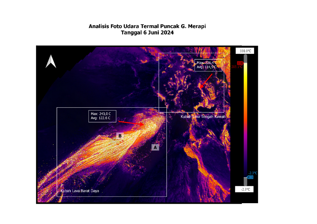
The highest hot spot was observed at 243°C, lower than the previous measurement temperature. The morphology of the median dome is relatively constant. The highest hot spot was observed at 226.4°C, which was higher than the previous measurement temperature. Based on the analysis of aerial photos, the volume of the southwest dome was measured at 2,335,200 m3 and that of the central dome at 2,362,800 m3.
Seismicity
This week, the seismicity of Mount Merapi recorded:
3 warm cloud avalanche earthquakes (APG),
16 shallow volcanic earthquakes (VTB),
80 times multi-phase (MP) earthquakes,
2 low frequency (LF) earthquakes,
418 avalanche earthquakes(RF),
11 tectonic earthquakes (TT).
The intensity of earthquakes this week is lower than last week.

Deformation
The deformation of Mount Merapi monitored by EDM this week showed a shortening rate of 0.3 cm/day.
Rain and lahars
This week there was no rain at the Mount Merapi lookout and no additional runoff was reported in the rivers that originate on Mount Merapi.
Conclusion
Based on the results of visual and instrumental observations, it was concluded that: The volcanic activity of Mount Merapi is still quite high in the form of effusive eruptive activity. The activity status is set to the “SIAGA” level .
Source : BPPTKG
Photos : BPPTKG , imamismadin
Chile , Laguna del Maule :
Seismology
The seismological activity of the period was characterized by the recording of:
830 seismic events of type VT, associated with the fracturing of rocks (Volcano-Tectonics). The most energetic earthquake had a local magnitude (ML) value equal to 3.0, located 2.4 km south-southeast of the center of the lagoon, at a depth of 4.7 km.
10 LP type seismic events, associated with fluid dynamics inside the volcanic system (Long Period). The size of the largest earthquake evaluated from the Reduced Displacement (RD) parameter was equal to 2.2 cm2.
Fluid geochemistry
No anomalies have been reported in the emissions of sulfur dioxide (SO2) into the atmosphere in the area near the volcanic complex, according to data published by the Tropospheric Monitoring Instrument (TROPOMI) and the Ozone Monitoring Instrument (OMI) Sulfur Dioxide Group.
Satellite thermal anomalies
During the period, no thermal alerts were recorded in the area associated with the volcanic complex, according to the analytical processing of Sentinel 2-L2A satellite images, in combination of false color bands.
Geodesy
The geodetic activity of the period was characterized by:
– Slight changes in direction of the horizontal components of GNSS stations.
– Changes in magnitude (acceleration) in the vertical components of GNSS stations.
– Slight amplitude changes in GNSS monitoring lines.
Thus, from the geodetic data obtained during the period, we observe trend shifts similar to previous periods, with slight variations in magnitude and in accordance with the inflationary process recorded since 2012 by the OVDAS geodetic monitoring network, with maximum rates which do not exceed 1.4. cm/month, a value similar to the historical average.
Surveillance cameras
The images obtained using a fixed camera, installed near the volcanic complex, did not record degassing columns or variations linked to surface activity.
Satellite geomorphological analysis
No morphological changes attributable to volcanic activity are recognized from Planet Scope and Sentinel L2-2A images.
The appearance of a new swarm and seismicity with ML 3.0 exclude the downward trend observed in recent months. Deformation rates show trends similar to those recorded historically, with slight variations in magnitude consistent with the inflationary process recorded since 2012.
Due to the above, its technical alert is maintained YELLOW TECHNICAL ALERT: Changes in the behavior of volcanic activity
Observation:
The area concerned is considered to be that located within a 2 km radius around the passive CO2 degassing zone.
Source : Sernageomin
Photo : OAVV
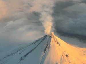
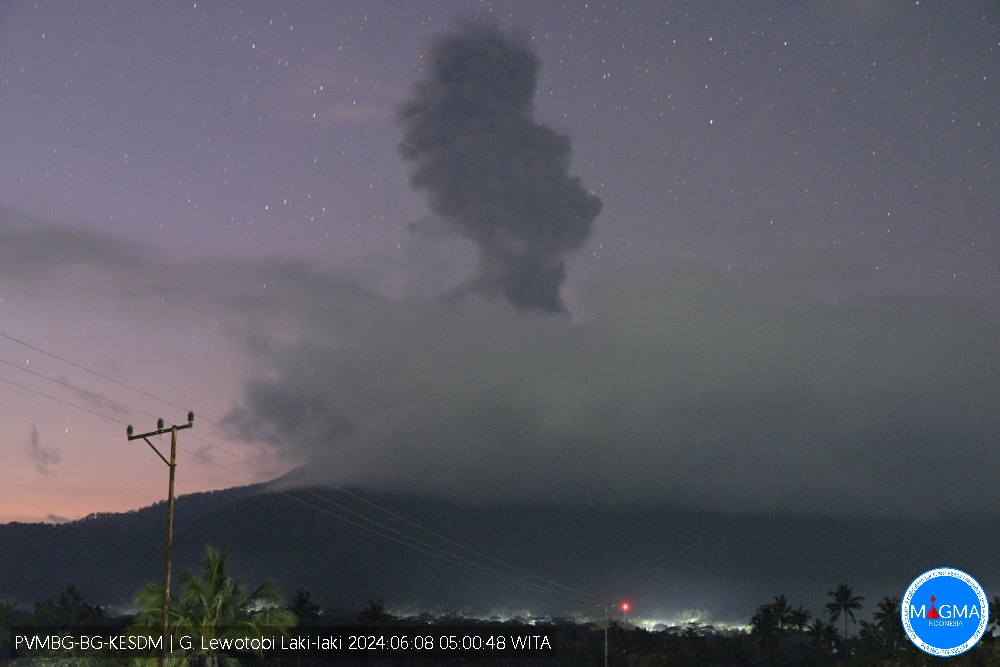
Indonesia , Lewotobi Laki-laki :
An eruption of Mount Lewotobi Laki Laki occurred on Saturday June 8, 2024 at 04:57 WITA with the height of the ash column observed at ± 800 m above the summit (± 2384 m above sea level) . The ash column was observed to be gray with thick intensity, oriented to the West and Northwest. This eruption was recorded on a seismograph with a maximum amplitude of 47.3 mm and a duration of 574 seconds.
SEISMICITY OBSERVATIONS
5 eruption/explosion earthquakes with an amplitude of 10.3 to 47.3 mm and an earthquake duration of 167 to 784 seconds.
25 shallow volcanic earthquakes with an amplitude of 4.4 to 14.8 mm and an earthquake duration of 7 to 11 seconds.
9 deep volcanic earthquakes with an amplitude of 5.1 to 20 mm and an earthquake duration of 9 to 16 seconds.
1 local tectonic earthquake with an amplitude of 3.7 mm, and duration of the earthquake of 34 seconds.
3 distant tectonic earthquakes with an amplitude of 8.1 to 47.3 mm, and an earthquake duration of 65 to 149 seconds.
RECOMMENDATION
1. Communities around Mount Lewotobi Laki Laki and visitors/tourists do not carry out any activities within a radius of 2 km from the center of the eruption and in a sector of 3 km in the North-North-East direction and 5 km in the direction of the North East Sector.
2. The public should remain calm and follow the instructions of the regional government and not believe rumors whose origin is unclear.
Source et photo : Magma Indonésie.