
October 31 , 2023.
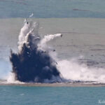
Japan , Iwo Jima :
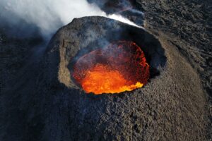
An eruption with the release of volcanic blocks occurs on Iwo Jima, with an eruption of 20 meters every few minutes.
An eruption accompanied by volcanic blocks occurred on Iwo Jima in the Ogasawara Islands on October 30, as confirmed by a Mainichi Shimbun newspaper plane flying overhead. According to experts, the eruption appears to be a phreato-magmatic explosion caused by contact between magma and seawater.
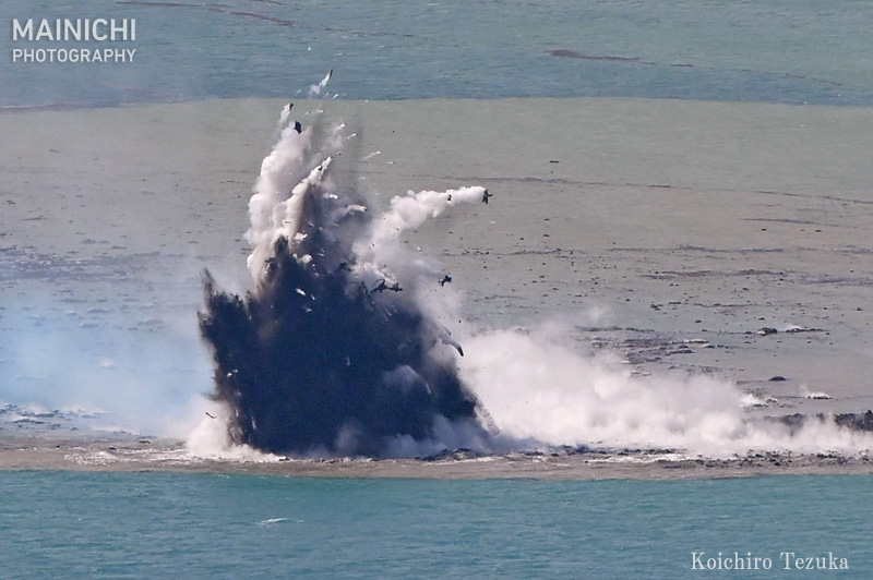
The eruption occurred about 1 km offshore from Okinahama Beach, located on the south side of Iwo Jima. A mixture of volcanic ash and seawater was violently ejected to a height of about 20 to 30 meters every few minutes. Black cinder blocks were also confirmed and pumice was ejected from the crater, flowing to the other side of the island.
According to the Japan Meteorological Agency, eruptions have been confirmed at approximately the same location in July-August, October and December 2022. In recent years, volcanic activity on Iwo Jima has continued to cause the rise of the island, some places have risen by more than 10 meters over the last 10 years.
Source : Mainichi Shimbun via Sherine France.
Photo : Koichiro Tezuka / Mainichi .
Iceland , Reykjanes Peninsula :
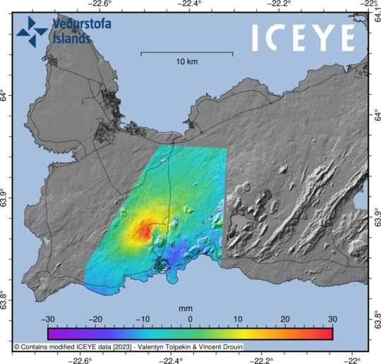
Ground deformation continues northwest of Þorbjörn . New satellite data has not arrived yet.Updated 30th of October at 11:30am
The Sentinel satellite data expected to be received yesterday has not arrived yet, however the cGPS data in the area around Svartensgi and Þorbjörn show that the deformation is still ongoing. The deformation rate since the beginning of this intrusive event has been slightly decreasing over time. Preliminary deformation model results suggest the average depth, where the magmatic instrusion is occurring, is about 4 km.
Over the past 24 hours about 1300 earthquakes have been automatically detected on the Reykjanes Peninsula. Most of this seismicity is located at a depth between 2-4 km. The largest earthquake had a magnitude M2.7 on the 29 October at 11:40UTC.
Scientists from the Icelandic Meteorological Office are undertaking additional surface measurements in the area, including geochemical observations. Regular communication is maintained between IMO, HS-Orka and the Civil Protection while this unrest continues.
The land on Iceland’s Reykjanes peninsula has risen some 3 cm [1.2 in] since October 27, indicating an eruption might be on the way. Uplift (the scientific term for this geological activity) has occurred before all three eruptions on Reykjanes in the past three years. While there are no indications that an eruption is imminent, the Department of Civil Protection and Emergency Management has declared an uncertainty phase on the Reykjanes peninsula.
Grindavík and Mount Þorbjörn
Earthquakes and faster uplift
A powerful earthquake swarm began on the Reykjanes peninsula on the night of October 24 just north of the town of Grindavík. The most powerful earthquakes at the start of the swarm measured M3.9 and M4.5. More than 7,000 earthquakes have been detected in the area since, including an M5.0 earthquake on October 27.
On October 27, the land in the area began to rise, indicating a magma intrusion in the earth below. This is the fifth time that uplift is measured at the location since 2020. The rate of uplift is faster than uplift that occurred in 2020 and 2022 in a similar area. All three eruptions that have occurred on the Reykjanes peninsula in the past three years were preceded by earthquakes and uplift.
Land rise close to Blue Lagoon
The midpoint of the uplift is some 1.5km to the northwest of Þorbjörn mountain, near the Blue Lagoon. The Blue Lagoon’s Director of Sales, Operations, and Services told RÚV that the company is meeting with authorities daily to monitor the situation and has updated their contingency plans. The temperature of the water in the lagoon is monitored regularly and no changes have been detected.
Sources : IMO, Iceland Rewiew.
Photos : IMO , Golli / Iceland Rewiew.
Alaska , Aniakchak :
AVO/USGS Volcanic Activity Notice
Current Volcano Alert Level: UNASSIGNED
Previous Volcano Alert Level: NORMAL
Current Aviation Color Code: UNASSIGNED
Previous Aviation Color Code: GREEN
Issued: Monday, October 30, 2023, 2:14 PM AKDT
Source: Alaska Volcano Observatory
Notice Number: 2023/A1557
Location: N 56 deg 54 min W 158 deg 12 min
Elevation: 4400 ft (1341 m)
Area: Alaska Peninsula
Volcanic Activity Summary:
The Alaska Volcano Observatory (AVO) has experienced the failure of seismic monitoring equipment at Aniakchak Volcano and the remaining instrumentation is insufficient to establish that the volcano is at a typical background level. It is not possible to repair this equipment until next summer’s field season. As a result, AVO is unable to (1) assess whether this volcano may be building towards an eruption and (2) quickly confirm or dismiss reports of activity.
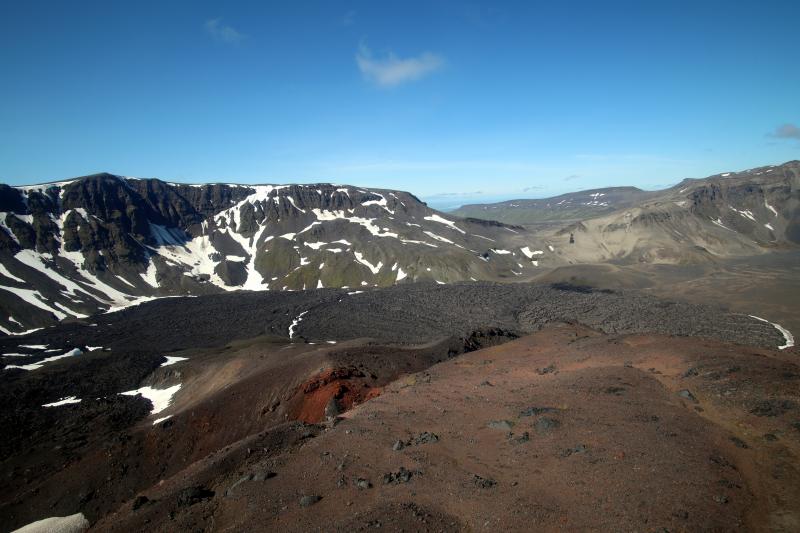
Aniakchak caldera west rim and Vent Mountain flow.
Because this volcano is no longer seismically monitored at adequate levels, the Aviation Color Code and Volcano Alert Level are changed to UNASSIGNED/UNASSIGNED. As at other volcanoes without real-time seismic networks, AVO will continue to use satellite data, regional seismic, infrasound and lightning networks, and reports from pilots and ground observers to detect signs of eruptive activity.
Remarks:
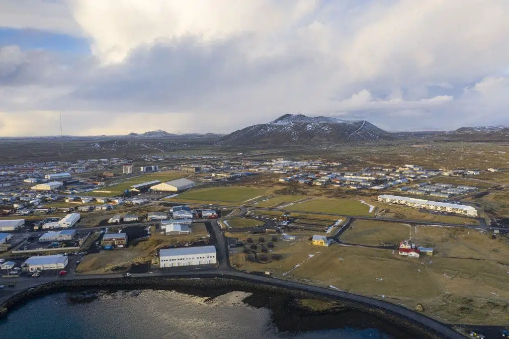
Aniakchak volcano, located in the central portion of the Alaska Peninsula, consists of a stratovolcano edifice with a 10 km (6 mile) diameter summit caldera. The caldera-forming eruption occurred around 3,500 years ago. Postcaldera eruptions have produced lava domes, tuff cones, and larger spatter and scoria cone structures including Half-Cone and Vent Mountain all within the caldera. The most recent eruption occurred in 1931 and created a new vent and lava flows on the western caldera floor while spreading ash over much of southwestern Alaska. Aniakchak volcano is 25 km (15 miles) southeast of the nearest community, Port Heiden, and 670 km (416 miles) southwest of Anchorage, Alaska.
Source : AVO
Photo : Botnick, Steve / Alaska Volcano Observatory / U.S. Geological Survey.
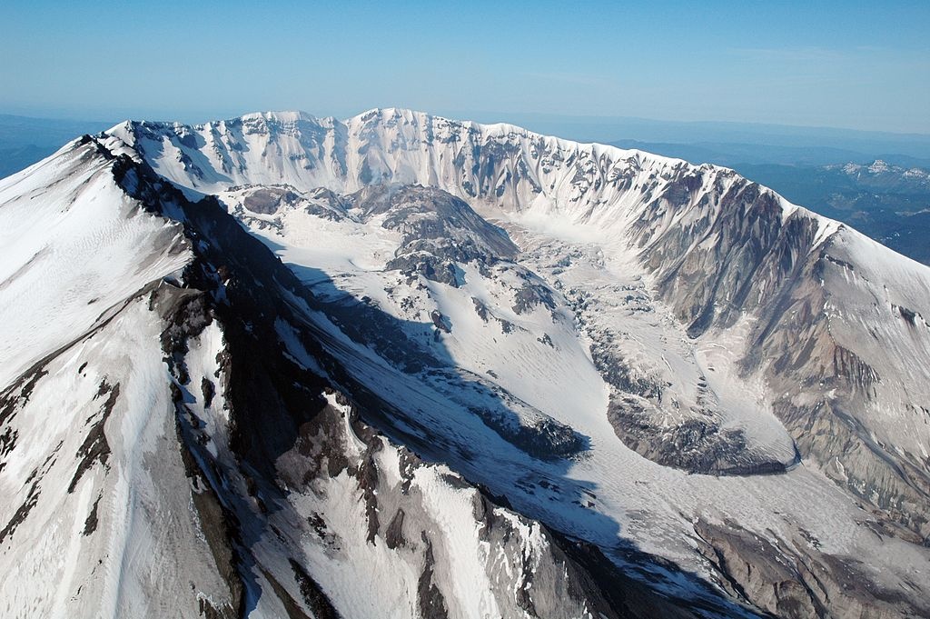
United – States , Mount St Helens :
Monday, October 30, 2023, 3:53 PM PDT (Monday, October 30, 2023, 22:53 UTC)
46°12′ N 122°10’48 » W,
Summit Elevation 8363 ft (2549 m)
Current Volcano Alert Level: NORMAL
Current Aviation Color Code: GREEN
Summary:
Over the past three months, seismicity at Mount St. Helens has been elevated but remains consistent with background seismicity. Most of the earthquakes have been less than magnitude 1.0 and too small to be felt at the surface. No significant changes have been observed in other monitoring parameters and there are no signs of an imminent eruption.
There is no change in Volcano Alert Level or Aviation Color Code at this time. Mount St. Helens remains at normal, background levels of activity.
Current Observations
At Mount St. Helens, over 400 earthquakes have been located by the Pacific Northwest Seismic Network since July 15, 2023. In late August to early September, about 40-50 earthquakes were located per week, and more recently, the number has been about 30 located earthquakes per week. To compare, since 2008, on average about 11 earthquakes have been located per month at Mount St. Helens.
The largest earthquake in this recent period was a magnitude 2.4 that occurred on August 27, 2023. Most of the events have been less than a magnitude 1.0. Earthquake depths are between 2 and 6 km (1.2 and 3.7 miles) below sea level, which is approximately 4 to 8 km (2.5 and 5 miles) below the crater floor.
No changes have been detected in ground deformation, volcanic gas or thermal emissions at Mount St. Helens. No changes have been observed at other Cascade Range volcanoes.
Prognosis
Short-term increases in earthquake rates are common at Mount St. Helens and are considered part of the background seismicity. The current seismicity represents the largest short-term increase in earthquake rates since the last eruption ended in 2008. However, longer duration sequences with more events occurred in 1988-1992, 1995-1996 and 1997-1999. None of the sequences in the 1980’s and 90’s directly led to eruptions.
Small magnitude earthquakes located beneath Mount St. Helens at depths well below sea level are generally thought to be associated with pressurization of the magma transport system. One cause for this pressurization is the arrival of additional magma, a process called recharge. Mount St. Helens is fed by magma that forms near the base of the crust at depths of about 25 km (~16 miles). Magma slowly rises through the lower crust and accumulates in a reservoir about 4‒10 km (~2.5‒6 miles) below sea level. Recharge events can occur when magma enters this upper reservoir and increases stresses that lead to earthquakes.
High rates of seismicity, interpreted as recharge, have been observed in the past at Mount St. Helens and at other volcanoes and can continue for many years without an eruption.
Source et photo : CVO
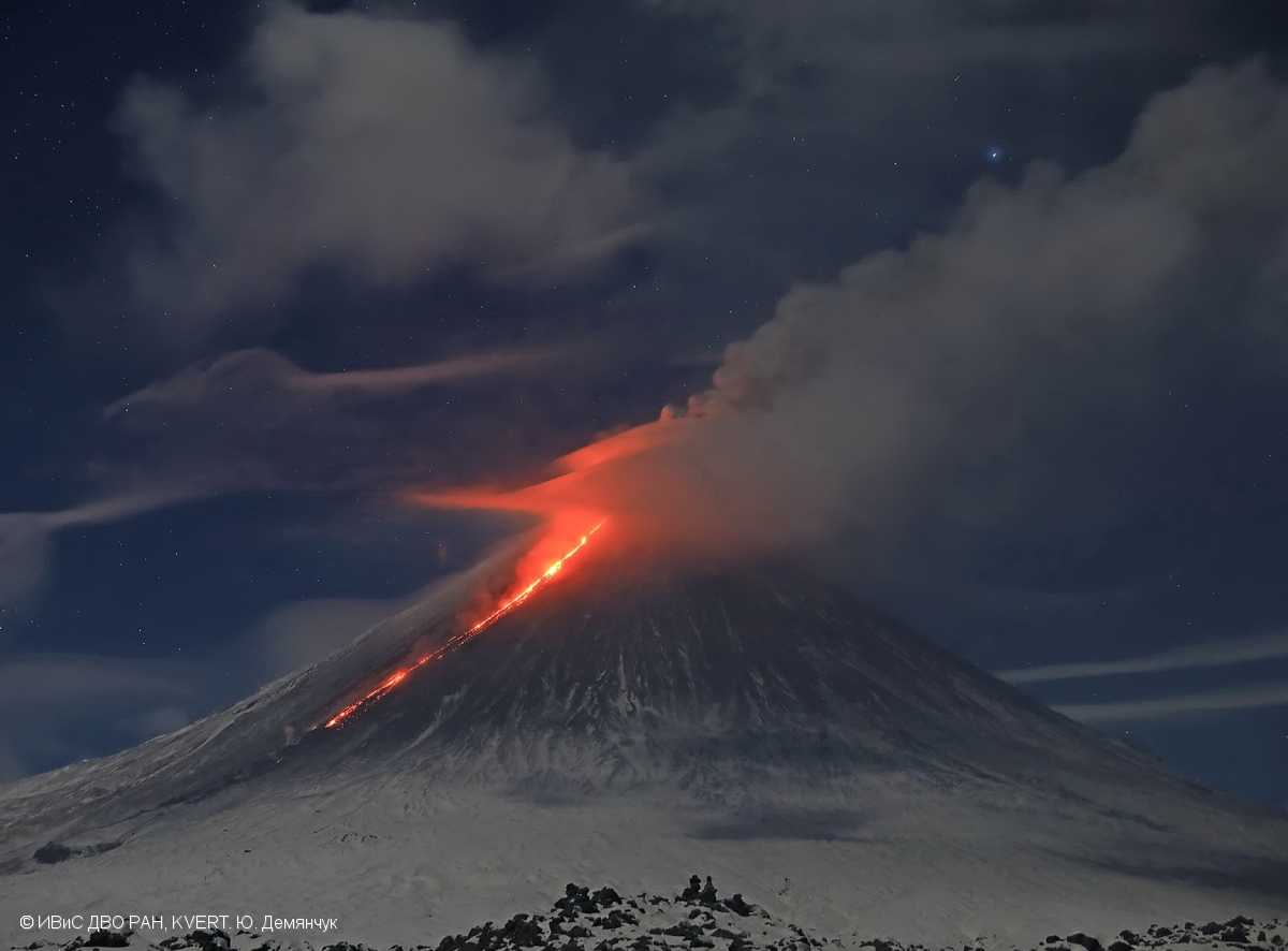
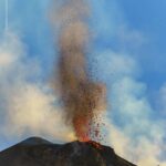
Kamchatka , Klyuchevskoy :
VOLCANO OBSERVATORY NOTICE FOR AVIATION (VONA)
Issued: October 31 , 2023
Volcano: Klyuchevskoy (CAVW #300260)
Current aviation colour code: RED
Previous aviation colour code: red
Source: KVERT
Notice Number: 2023-138
Volcano Location: N 56 deg 3 min E 160 deg 38 min
Area: Kamchatka, Russia
Summit Elevation: 4750 m (15580 ft)
Volcanic Activity Summary:
Strong activity of the volcano continues. Satellite data by KVERT showed the ash column rose up to 8.7 km a.s.l., and the ash plume is extending for 365 km to the south-southeast of the volcano. Probably, the ash plume is containing mainly old ash from collapses in Apakhonchichsky chute.
The summit explosive-effusive eruption of the volcano continues. Ash explosions up to 12 km (39,400 ft) a.s.l. could occur at any time. Ongoing activity could affect international and low-flying aircraft.
Volcanic cloud height:
8500-8700 m (27880-28536 ft) AMSL Time and method of ash plume/cloud height determination: 20231031/0510Z – Himawari-9 14m15
Other volcanic cloud information:
Distance of ash plume/cloud of the volcano: 365 km (227 mi)
Direction of drift of ash plume/cloud of the volcano: SSE / azimuth 153 deg
Time and method of ash plume/cloud determination: 20231031/0510Z – Himawari-9 14m15
Remarks:
The summit explosive-effusive eruption of the volcano continues. Against the background of explosive activity of the Strombolian type (lava fountaining in the volcanic crater up to 500 m), the lava flow continue to effuse along the Apakhonchichsky chute on the southeastern slope of the volcano.
Source : Kvert
Photo : Yu. Demyanchuk, IVS FEB RAS, KVERT

No comment yet, add your voice below!