September 22 , 2023.
Kamchatka , Klyuchevskoy :
VOLCANO OBSERVATORY NOTICE FOR AVIATION (VONA)
Issued: September 22 , 2023
Volcano: Klyuchevskoy (CAVW #300260)
Current aviation colour code: ORANGE
Previous aviation colour code: yellow
Source: KVERT
Notice Number: 2023-103
Volcano Location: N 56 deg 3 min E 160 deg 38 min
Area: Kamchatka, Russia
Summit Elevation: 4750 m (15580 ft)
Volcanic Activity Summary:
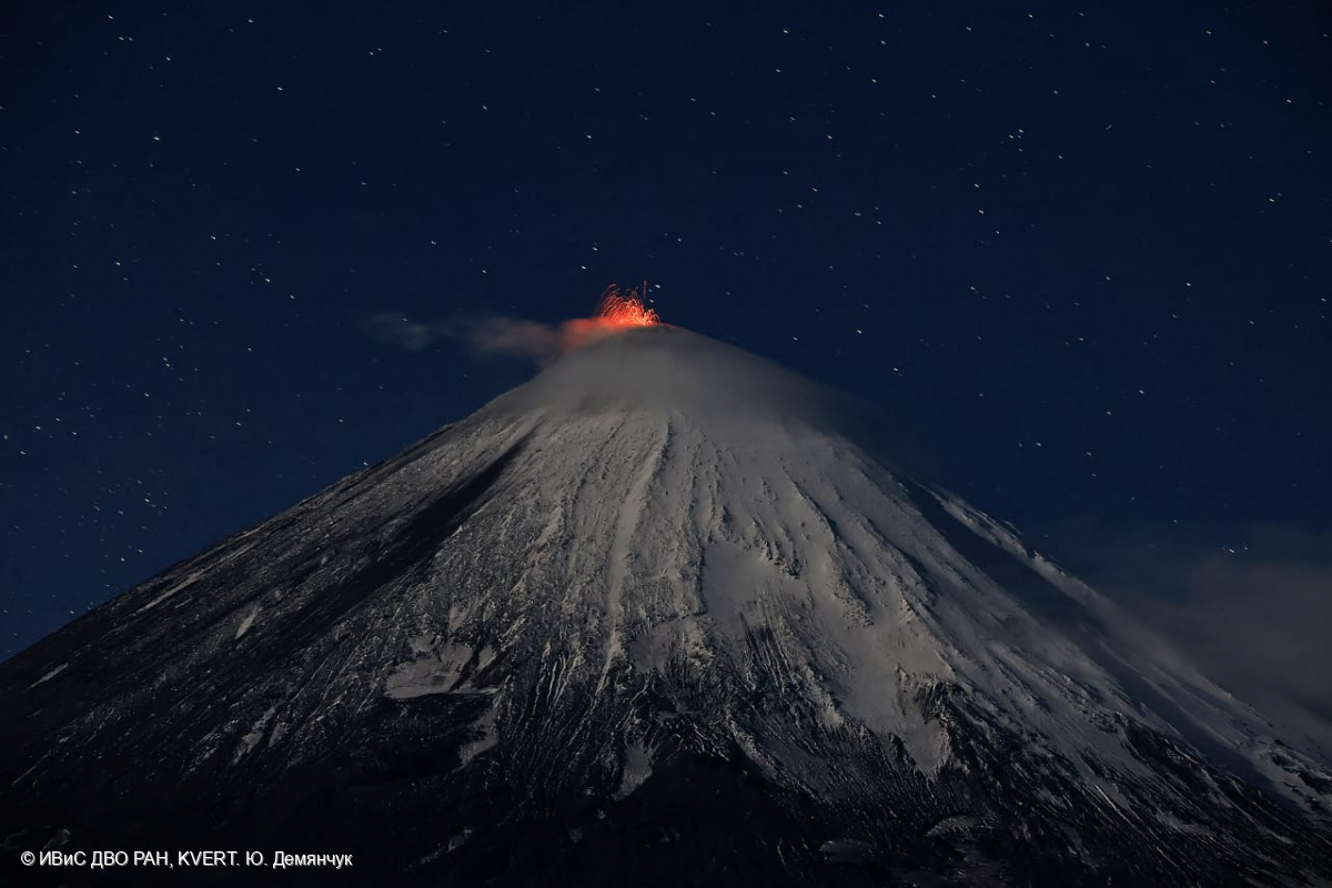
Satellite data by KVERT show a strong wind lifts ash from the northern slopes of Klyuchevskoy volcano (Sheveluch’s ash from April 10-13, 2023 eruption), and a plume of resuspended ash is extending about 50 km to the east of the volcano.
The summit explosive-effusive eruption of the volcano continues. Ash explosions up to 6 km (19,700 ft) a.s.l. could occur at any time. Ongoing activity could affect low-flying aircraft.
Volcanic cloud height:
2000-2500 m (6560-8200 ft) AMSL Time and method of ash plume/cloud height determination: 20230922/0330Z – Himawari-9 14m15
Other volcanic cloud information:
Distance of ash plume/cloud of the volcano: 50 km (31 mi)
Direction of drift of ash plume/cloud of the volcano: E / azimuth 87 deg
Time and method of ash plume/cloud determination: 20230922/0330Z – Himawari-9 14m15
Remarks: resuspended ash
Source : Kvert
Photo : Yu. Demyanchuk, IVS FEB RAS, KVERT
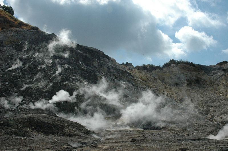
Italy , Campi Flegrei :
Weekly bulletin, from September 11, 2023 to September 17, 2023. (Issue date September 19, 2023)
SUMMARY STATEMENT OF ACTIVITY
In light of the monitoring data, it appears:
1) SISMOLOGY: In the week of September 11 to 17, 2023, in the Campi Flegrei area, 41 earthquakes of magnitude Md≥0.0 (Mdmax=2.9±0.3) were located.
2) DEFORMATIONS: From January 2023, the average value of the lifting speed in the maximum deformation zone is approximately 15±3 mm/month. The uplift recorded at the RITE GNSS station measures approximately 24.5 cm since January 2022.
3) GEOCHEMISTRY: There are no significant changes in the geochemical parameters monitored during the reference period. The temperature sensor installed in a fumarole emission 5 meters from the main Pisciarelli fumarole showed an average value of ~95°C, the condensation temperature of the fumarole fluid. The absence of fluid in the Pisciarelli fossa remains.
GEOCHEMISTRY
During the reference period, the data monitored by the geochemical network did not show significant variations in the acquired parameters.
In the Pisciarelli area (outer north-eastern slope of Solfatare), which has shown in recent years the greatest variations in the degassing process, the values of the soil CO2 flux recorded continuously by the FLXOV8 station highlight the continuation of multi-year trends already identified previously (see Monthly Bulletins). During the last week, CO2 fluxes measured from the ground did not show significant variations compared to previous periods.
Over the past week, there have been no significant changes in temperature, the average value of which was ~95°C, the condensation temperature of the fumarolic fluid.
Source : INGV
Photo : Manuel Mauer
Alaska , Shishaldin :
54°45’19 » N 163°58’16 » W,
Summit Elevation 9373 ft (2857 m)
Current Volcano Alert Level: WATCH
Current Aviation Color Code: ORANGE
Activity continues at Shishaldin Volcano. Seismicity remains elevated with tremor and small earthquakes occurring over the past day. Elevated surface temperatures were observed in clear overnight satellite views and web camera views this morning showed a small ash deposit on the upper flanks of the volcano to the northeast. No ash clouds have been observed over the past day.
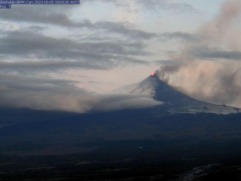
Webcam image from south of Shishaldin (station BRPK) showing high fountaining and light ash emissions at the start of « event 9 » of the 2023 eruption.
There have been ten periods of elevated eruptive activity resulting in significant ash emissions and mass flows of volcanic debris on the volcano’s flanks since the onset of the current eruption. These periods of elevated eruptive activity have been preceded by increases in seismicity in the hours before they occur. Collapse of accumulated lava near the summit crater can occur without warning and generate hot mass flows on the upper flanks and small volcanic ash clouds. The ongoing eruptive period started on July 12, and it is unknown how long this eruptive episode will last. However, previous eruptions of Shishaldin Volcano have lasted weeks to months with repeated cycles of activity like those seen over the last month.
Local seismic and infrasound sensors, web cameras, and a geodetic network monitor Shishaldin Volcano. In addition to the local monitoring network, AVO uses nearby geophysical networks, regional infrasound and lighting data, and satellite images to detect eruptions.
Source : AVO
Japan , Nishinoshima :
Observations of June 22, 2023.
No eruption was detected and a white plume rose from the central crater of the pyroclastic cone to a height of approximately 1,200 m.
Multiple white fumaroles were observed released from the inner rim of the crater on the west side and the southeast flank of the mountain to the foot of the mountain.
The distribution of sublimated sulfur was observed on the southeastern edge of the crater and on the southern slope of the mountain. The rim and interior of the crater in the northern and eastern regions were not visible due to volcanic smoke.
Discolored brown to green waters were distributed over a wide area almost around the island, and light green discolored waters were observed off the southern coast of the island.
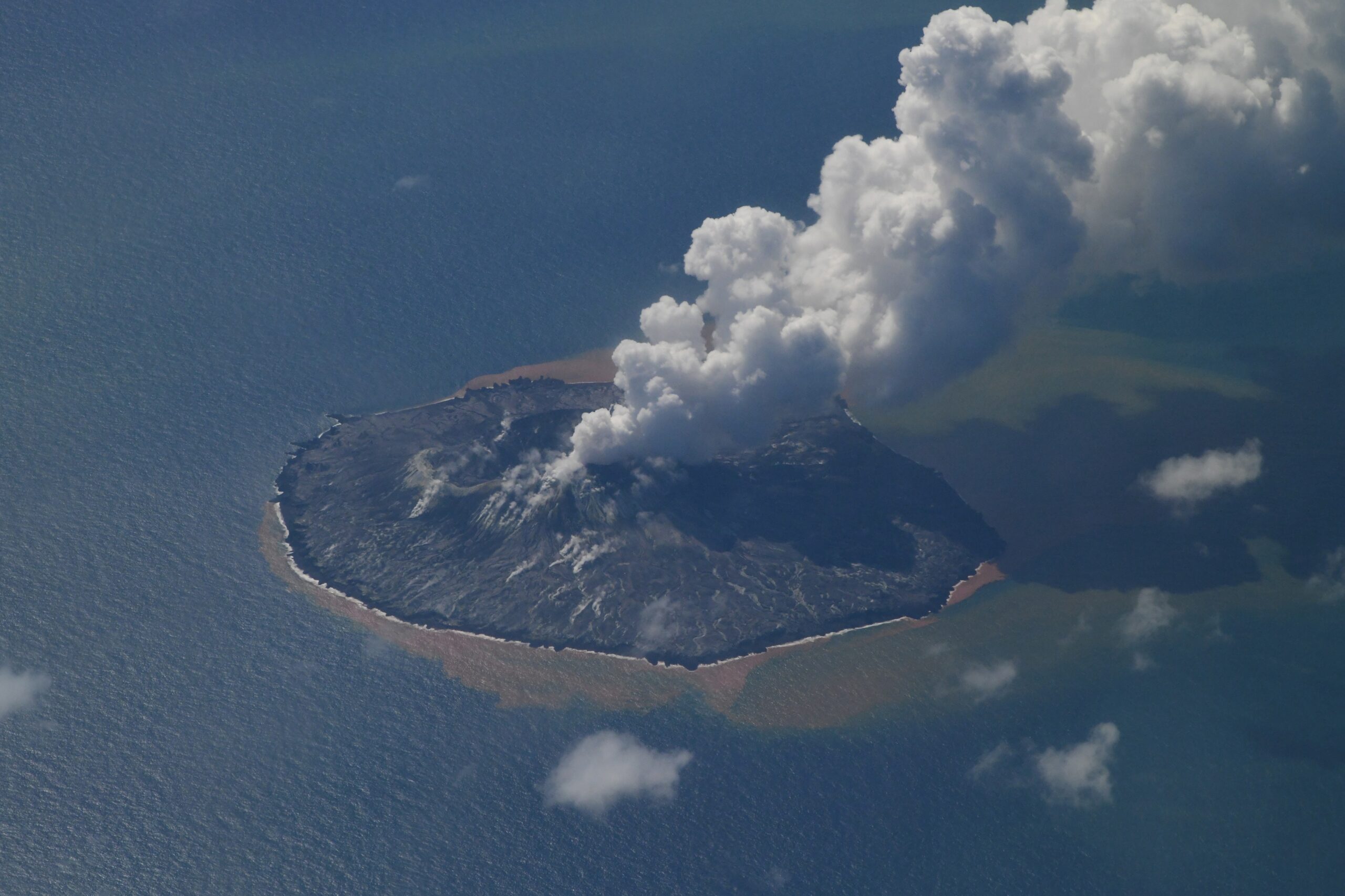
It is a volcanic island located about 930 km south of Tokyo and the surface of the island is 650 mx 200 m. The top of the island is close to the center (27°14.8′N, 140°52.5′E, 25 m), and it is a flat andesitic island (SiO2 58-60%) overall. The volcanic edifice consists of an older volcanic edifice located 12 km west of Nishinoshima and a younger volcanic edifice which includes Nishinoshima. The older volcanic edifice presents a valley dug into the slope of the volcanic edifice and is displaced by faults to the North-Northwest in a South-East direction. receives. In contrast, in more recent volcanic bodies, valley development is not as pronounced and ripples caused by subsidence of surface sediments can be observed. Several lateral volcanic bodies are also visible, and magnetic anomalies corresponding to each can be observed. In 1973, Nishinoshima, which had no record of an eruption since recorded history, began to act on the ocean floor near Nishinoshima, forming a new island. After that, Niijima was connected to Nishinoshima, and most of Niijima was eroded by waves, and only part of it remains today.
Source : kaiho.mlit.go
Photo : Kaiho/ Gardes cotes Japonais
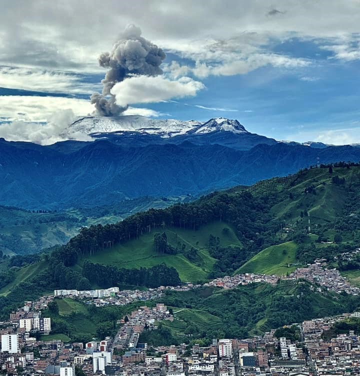
Colombia , Nevado del Ruiz :
Weekly bulletin on the activity of the Nevado del Ruiz volcano
From the monitoring of the activity of the NEVADO DEL RUIZ VOLCANO, the MINISTRY OF MINES AND ENERGY through the COLOMBIAN GEOLOGICAL SERVICE (SGC) reports that:
In the week of September 12-18, 2023, the volcano continued to exhibit unstable behavior, characterized by low activity levels and minor variations in most monitored parameters.
Seismic activity associated with the fracturing of rocks inside the volcanic edifice increased in the number of recorded earthquakes and decreased in the seismic energy released, compared to the previous week.
Most of the earthquakes were of low energy (magnitude less than 1) and were mainly located on the northwest flank of the volcano, at distances between 7 and 9 km from the Arenas crater, and to a lesser extent, in the Arenas crater. and under the other flanks of the volcano within a maximum radius of 4 km from the crater.
The depths of the earthquakes varied between 1 and 9 km from the top of the volcano. September 13 and 14 stand out, during which a greater number of earthquakes were recorded in the northwest sector of the volcano.
Compared to the previous week, seismicity linked to fluid dynamics inside volcanic conduits showed a decrease in earthquakes associated with the continuous emission of gas and ash and a slight increase in associated earthquakes to pulsatile ash emissions. This increase was observed in the number of recorded earthquakes and in the seismic energy released. In general, the seismic signals showed low to moderate energy levels and some of them, in addition to being associated with emissions of ash and gases into the atmosphere, were associated with changes in relative temperature of the material emitted. Both phenomena were confirmed by conventional or thermographic cameras used to monitor the volcano.
Regarding surface activity, the volcano continued to emit water vapor and gases into the atmosphere, however, sulfur dioxide (SO2) outgassing rates were low. The maximum height of the column of gas and ash vertically was 900 m on September 17, and 2000 m in dispersion on September 13, values measured at the summit of the volcano. On the other hand, from satellite monitoring platforms, several thermal anomalies were detected at the bottom of the crater, with low to moderate energy levels.
Source : SGC
Photo : Alex Jimenez Matiz