September 21 , 2023.
Alaska , Great Sitkin :
52°4’35 » N 176°6’39 » W,
Summit Elevation 5709 ft (1740 m)
Current Volcano Alert Level: WATCH
Current Aviation Color Code: ORANGE
Slow eruption of lava in the summit crater continues. Seismicity was quiet over the past day. Clouds obscured satellite and web camera views of the volcano.
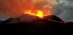
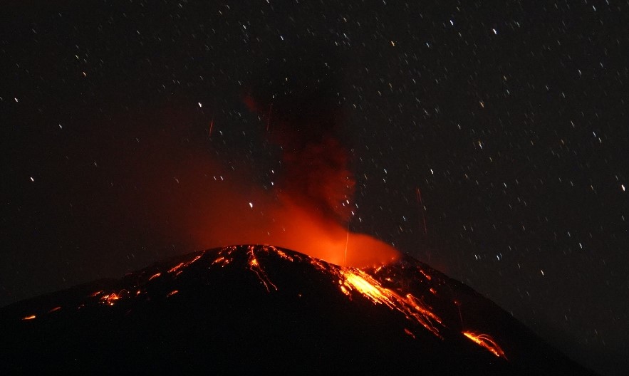
Oblique view of Great Sitkin Volcano looking northeast at the active lava flows from the crater. Lava flows spilling out of the crater on formed in 2021 and 2022.
The current lava flow at Great Sitkin Volcano began erupting in July 2021. No explosive events have occurred since a single event in May 2021.
Local seismic and infrasound sensors, web cameras, regional infrasound and lightning networks, and satellite data are used to monitor the volcano.
AVO reported that slow lava effusion likely continued at Great Sitkin during 13-19 September, producing a thick flow in the summit crater that mainly expanded E. A few daily earthquakes were recorded by the seismic network and seismicity was characterized as low. Weather clouds often prevented satellite and webcam observations, though no activity was observed on a few of the days with partly cloudy weather. The Volcano Alert Level remained at Watch (the third level on a four-level scale) and the Aviation Color Code remained at Orange (the third color on a four-color scale).
Source : AVO , GVP.
Photo : Loewen, Matt / AVO/USGS.
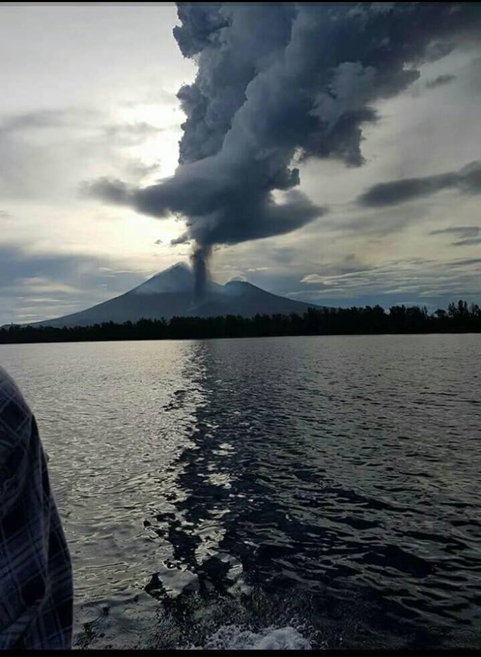
Indonesia , Ili Lewotolok :
Mount Ili Lewotolok erupted on Thursday, September 21, 2023, at 08:55 WITA. The height of the eruptive column was observed to be ± 700 m above the peak (± 2,123 m above sea level). The ash column was observed to be gray with thick intensity, oriented to the West and Northwest. The eruption was recorded on a seismograph with a maximum amplitude of 36.4 mm and a duration of 58 seconds.
VOLCANO OBSERVATORY NOTICE FOR AVIATION – VONA
Issued : September 21 , 2023
Volcano : Ili Lewotolok (264230)
Current Aviation Colour Code : ORANGE
Previous Aviation Colour Code : orange
Source : Ili Lewotolok Volcano Observatory
Notice Number : 2023LEW057
Volcano Location : S 08 deg 16 min 19 sec E 123 deg 30 min 18 sec
Area : East Nusa Tenggara, Indonesia
Summit Elevation : 4554 FT (1423 M)
Volcanic Activity Summary :
Eruption with volcanic ash cloud at 00h55 UTC (08h55 local).
Volcanic Cloud Height :
Best estimate of ash-cloud top is around 6794 FT (2123 M) above sea level or 2240 FT (700 M) above summit. May be higher than what can be observed clearly. Source of height data: ground observer.
Other Volcanic Cloud Information :
Ash cloud moving from west to northwest. Volcanic ash is observed to be gray. The intensity of volcanic ash is observed to be thick.
Remarks :
Eruption recorded on seismogram with maximum amplitude 36.4 mm and maximum duration 58 second.
PVMBG reported that the eruption at Lewotolok continued during 12-19 September. According to the Darwin VAAC an ash plume rose 600 m above the summit and drifted WNW on 12 September. PVMBG noted that white-and-gray plumes rose 250-400 m above the summit and drifted W and NW on 13 and 16 September. White steam-and-gas plumes rose as high as 300 m and drifted W and NW on the other days. Webcam images captured incandescent material being ejected above the summit at 01h01 on 13 September and summit incandescence at 18h30 on 16 September. The Alert Level remained at 2 (on a scale of 1-4) and the public was warned to stay at least 2 km away from the summit crater.
Source : Magma Indonésie , GVP
Photo : Magma Indonésie
New Britain ( Papua New Guinea) , Ulawun :
Rabaul Volcano Observatory (RVO) reported a small eruption at Ulawun during 14-15 September. Minor incandescence at the summit crater was first visible at around 21h07 on 14 September from Ulamona Observatory. The incandescence intensified, and eruption plumes reflecting the glow were visible in webcam images drifting NE. Starting at about 00h04 and lasting to about 08h00 on 15 September there were brief periods when the plumes appeared darker, likely due to denser and more intense emissions. The plumes drifted W and WSW. Rumbling noises were reported, though they became less frequent by 08h00. The Alert Level was raised to Stage 2 (the second level on the four-level scale).
Staff from the West New Britain Provincial Disaster Office conducted a field inspection on 15 September and found only minor ashfall around the volcano. During 08h00 on 15 September to 14h30 on 19 September the volcano was quiet; small volumes of diffuse white emissions sometimes rose from the summit and drifted W and WSW. On 19 September RVO recommended that the Alert Level should be lowered to Stage 1.
Increased seismicity coincided with the eruption. During most of 14 September RSAM values were 200-300, though they began to increase at about 19h55 and reached a value of around 800 by midnight. RSAM continued to increase; values reached 1,600 by 01h00 on 15 September, rapidly increased during 01h00-02h00, and reached a value of 4,060 almost two hours later at 03h00. Seismicity was dominated by continuous low-frequency volcanic tremors. Seismicity began to decline at 07h00, reached background levels by 09h00, and remained low with values of 200-450. During 16-19 September seismicity was characterized by low level volcanic tremors with sporadic occurrences of discrete, small, low-frequency volcanic events. RSAM values were around 200.
Source : RVO , GVP
Photo : Auther A Balisi
Hawaii , Kilauea :
Tuesday, September 19, 2023, 9:50 AM HST (Tuesday, September 19, 2023, 19:50 UTC)
19°25’16 » N 155°17’13 » W,
Summit Elevation 4091 ft (1247 m)
Current Volcano Alert Level: ADVISORY
Current Aviation Color Code: YELLOW
Activity Summary:
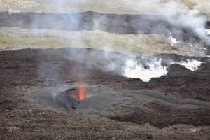
Kīlauea volcano is not erupting. No significant changes have been observed at the summit or in either rift zone since the summit eruption that began on September 10 ended on September 16. Future eruptions at Kīlauea’s summit remain possible and HVO continues to monitor activity. HVO will issue weekly Kīlauea updates on Tuesdays until further notice.
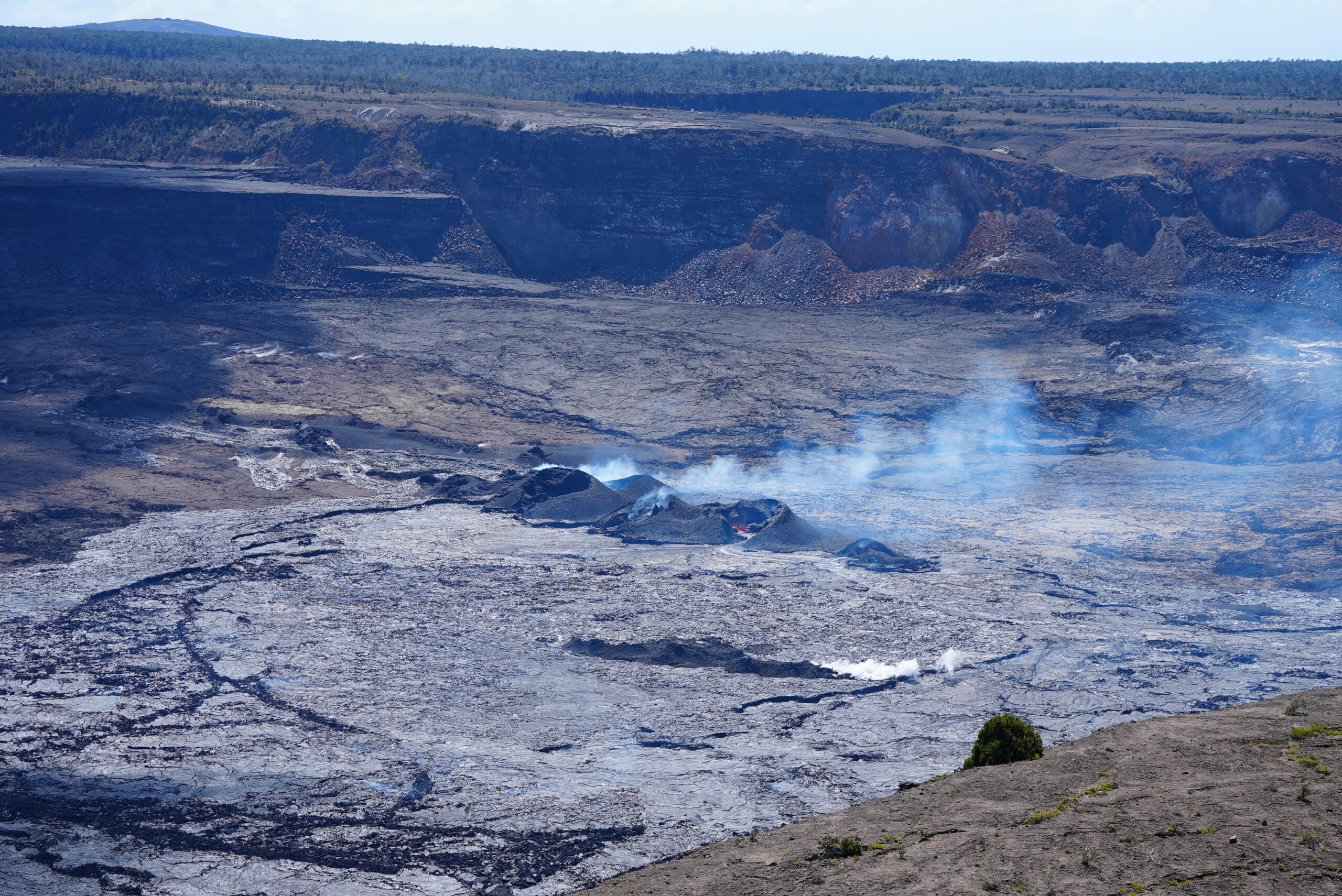
A wide view of the downdropped block at Kīlauea summit, from Uēkahuna bluff, showing the cones formed in the recent eruption. The eruption was shutting down at this point with very little vent activity, and only a weak gas plume.
Summit Observations:
Overnight webcam views showed sparse incandescent spots as lava erupted over the past week continues to cool on the downdropped block and Halemaʻumaʻu in Kīlauea’s summit caldera. It is unlikely that the recent eruption will resume based on the behavior of past, short-lived summit fissure eruptions at Kīlauea summit in 1982, 1975, 1974, and 1971, which all ended abruptly. Summit seismicity has remained low, with very few earthquakes over the past week, and tremor is at background levels following eruptive activity stopping on September 16. Summit tiltmeters recorded deflation as the eruption waned towards the end of last week. After several days of inflation, deflationary tilt has returned with little net deformation at the summit over the past week. Sulfur dioxide (SO2) emissions have decreased to near background levels and were measured at a rate of 200 tonnes per day on September 17.
Rift Zone Observations:
No unusual activity has been noted along the East Rift Zone or Southwest Rift Zone; steady rates of ground deformation and seismicity continue along both. Measurements from continuous gas monitoring stations on the middle East Rift Zone remain below detection limits for SO2.
Source : HVO
Photo : USGS/ M. Patrick.
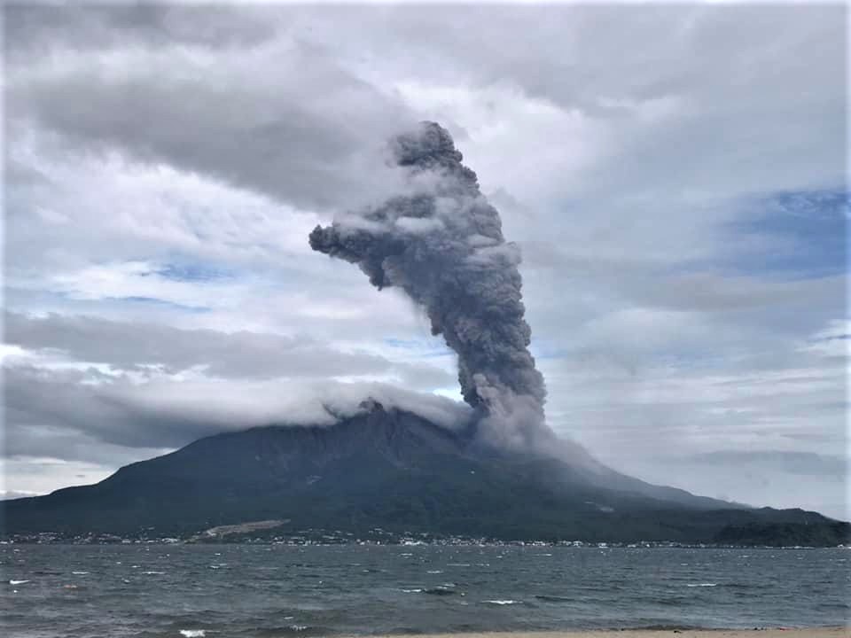
Japan , Sakurajima :
JMA reported ongoing activity at Minamidake Crater (Aira Caldera’s Sakurajima volcano) during 11-18 September and incandescence at the crater was observed nightly. Sulfur dioxide emissions averaged 1,900 tons per day on 11 September. An explosion at 00h18 on 11 September produced an ash plume that rose 1.1 km above the crater rim and ejected large blocks 300-500 m from the crater. An eruptive event at 16h42 produced an ash plume that rose 1.3 km. At 22h11 on 13 September an explosion produced an ash plume that rose 1.7 km and drifted N and ejected large blocks 500-700 m from the crater. The Alert Level remained at 3 (on a 5-level scale), and the public was warned to stay 2 km away from both craters.
The Aira caldera in the northern half of Kagoshima Bay contains the post-caldera Sakurajima volcano, one of Japan’s most active. Eruption of the voluminous Ito pyroclastic flow accompanied formation of the 17 x 23 km caldera about 22,000 years ago. The smaller Wakamiko caldera was formed during the early Holocene in the NE corner of the Aira caldera, along with several post-caldera cones. The construction of Sakurajima began about 13,000 years ago on the southern rim of Aira caldera and built an island that was finally joined to the Osumi Peninsula during the major explosive and effusive eruption of 1914. Activity at the Kitadake summit cone ended about 4850 years ago, after which eruptions took place at Minamidake. Frequent historical eruptions, recorded since the 8th century, have deposited ash on Kagoshima, one of Kyushu’s largest cities, located across Kagoshima Bay only 8 km from the summit. The largest historical eruption took place during 1471-76.
Source : GVP
Photo : Koki Arima