September 14 , 2023.
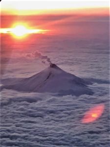
Hawaii , Kilauea :
Wednesday, September 13, 2023, 9:16 AM HST (Wednesday, September 13, 2023, 19:16 UTC)
19°25’16 » N 155°17’13 » W,
Summit Elevation 4091 ft (1247 m)
Current Volcano Alert Level: WATCH
Current Aviation Color Code: ORANGE
Activity Summary:
The Kīlauea summit eruption that began on September 10th continues this morning. Eruptive activity is confined to the downdropped block and Halemaʻumaʻu crater within Kīlauea’s summit caldera. No unusual activity has been noted along Kīlauea’s East Rift Zone or Southwest Rift Zone.
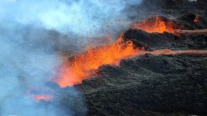
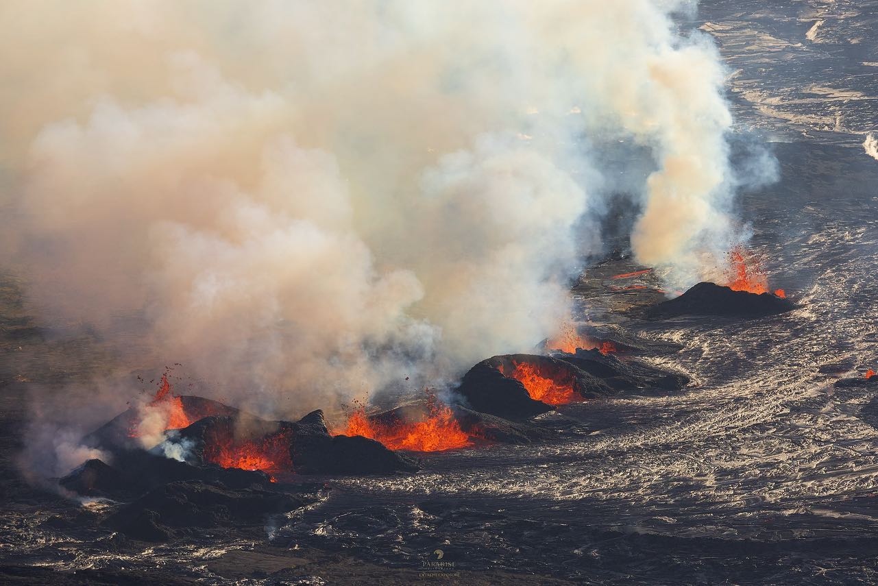
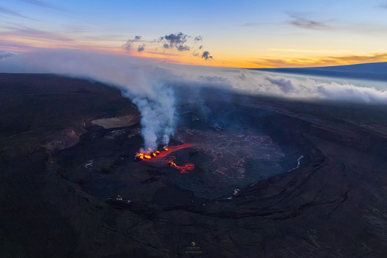
Halemaʻumaʻu crater Lava Lake Observations:
Several vents continue to erupt on the western side of the downdropped block within Kīlauea’s summit caldera and are generating lava flows onto Halema‘uma‘u crater floor. The roughly east-west trending active vents span approximately 0.5 miles (750 m) and had lava fountain heights of up to about 10 meters (32 feet) yesterday. From the erupting vents, pāhoehoe lava flows continue to travel in north and west directions onto Halema‘uma‘u crater floor; however, the area of active lava has retreated towards the vents compared to yesterday. This morning, active lava appears to be flowing only on the north and east parts of Halema‘uma‘u, the eastern boundary of which has been mostly covered by lava flows. The area north of the eruptive vents has become perched and is about 3 meters (15 feet) higher than the surrounding ground surface. Effusion rates appear down from initial eruptive rates, but remain high. The laser rangefinder is aimed at a western portion of Halema‘uma‘u, not near the new eruptive activity, and recorded nearly 6 m (20 feet) of uplift to this locality since the eruption started. This demonstrates that a significant amount of lava has intruded beneath the pre-existing crust within Halema‘uma‘u.
Summit Observations:
Summit tilt has remained deflationary over the past 24 hours. Summit seismic activity is dominated by eruptive tremor (a signal associated with fluid movement) with very few volcano tectonic earthquakes. Volcanic gas emissions in the eruption area are elevated; a sulfur dioxide (SO2) emission rate of 30,000 tonnes per day was measured yesterday morning, September 10. This is down significantly from the 190,000 tonnes per day measured just after the onset of the eruption on Sunday, September 10th.
Source : HVO
Photos : Bruce Omori / Paradise Helicopters
Montserrat , Soufrière Hills :
MVO reported that a very small increase in activity at Soufrière Hills during 1-8 September was characterized by small rockfalls coincident with volcano-tectonic earthquake activity and occasional small, low-frequency, volcanic earthquakes. The seismic network recorded 27 volcano-tectonic earthquakes spilt between two swarms recorded on 6 and 8 September. Minor rockfall activity and volcano-tectonic seismicity began at about 21h00 on 7 September and was ongoing. Rockfalls took place on the lava dome based on seismic data, though their locations could not be visually confirmed. The swarm on 8 September was followed by a long-period earthquake at 07h42, and a few additional smaller events. Access to the Upper Belham valley and Plymouth were suspended for the day out of an abundance of caution. Sulfur dioxide emissions averaged 436 tonnes per day on 1 September (measured from a boat) and 367 tonnes per day on 6 September (measured by helicopter). The Hazard Level remained at 1 (on a scale of 1-5).
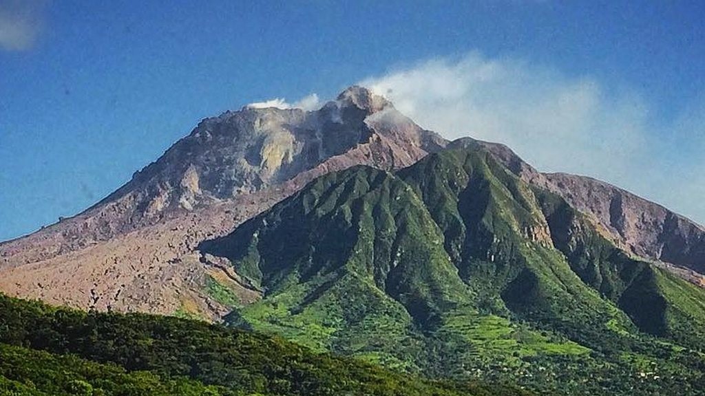
The complex, dominantly andesitic Soufrière Hills volcano occupies the southern half of the island of Montserrat. The summit area consists primarily of a series of lava domes emplaced along an ESE-trending zone. The volcano is flanked by Pleistocene complexes to the north and south. English’s Crater, a 1-km-wide crater breached widely to the east by edifice collapse, was formed about 2000 years ago as a result of the youngest of several collapse events producing submarine debris-avalanche deposits. Block-and-ash flow and surge deposits associated with dome growth predominate in flank deposits, including those from an eruption that likely preceded the 1632 CE settlement of the island, allowing cultivation on recently devegetated land to near the summit. Non-eruptive seismic swarms occurred at 30-year intervals in the 20th century, but no historical eruptions were recorded until 1995. Long-term small-to-moderate ash eruptions beginning in that year were later accompanied by lava-dome growth and pyroclastic flows that forced evacuation of the southern half of the island and ultimately destroyed the capital city of Plymouth, causing major social and economic disruption.
Source : GVP , Montserrat Volcano Observatory (MVO).
Photo : loopnews
Japan , Sakurajima :
JMA reported ongoing activity at both Minamidake Crater and Showa Crater (Aira Caldera’s Sakurajima volcano) during 4-11 September. Incandescence at Minamidake was observed nightly. Very small eruptive events occurred at both craters on 4 September. Sulfur dioxide emissions were slightly high at 1,600 tons per day on that same day. An explosion on 15h12 on 9 September produced an ash plume that rose 800 m above the crater rim and ejected large blocks 500-700 m from the crater. Another explosion at 00h18 on 11 September generated an ash plume that rose 1.1 km and ejected large blocks 300-500 m; an ash plume rose 1.3 km from an explosion at 16h42 on that same day. The Alert Level remained at 3 (on a 5-level scale), and the public was warned to stay 2 km away from both craters.
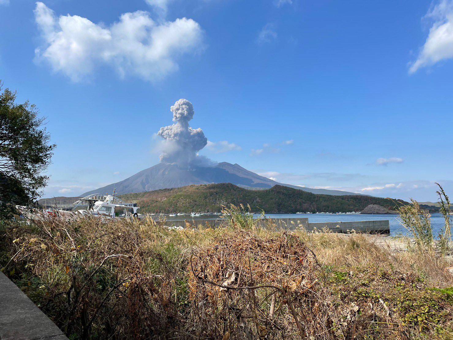
The Aira caldera in the northern half of Kagoshima Bay contains the post-caldera Sakurajima volcano, one of Japan’s most active. Eruption of the voluminous Ito pyroclastic flow accompanied formation of the 17 x 23 km caldera about 22,000 years ago. The smaller Wakamiko caldera was formed during the early Holocene in the NE corner of the Aira caldera, along with several post-caldera cones. The construction of Sakurajima began about 13,000 years ago on the southern rim of Aira caldera and built an island that was finally joined to the Osumi Peninsula during the major explosive and effusive eruption of 1914. Activity at the Kitadake summit cone ended about 4850 years ago, after which eruptions took place at Minamidake. Frequent historical eruptions, recorded since the 8th century, have deposited ash on Kagoshima, one of Kyushu’s largest cities, located across Kagoshima Bay only 8 km from the summit. The largest historical eruption took place during 1471-76.
Source : GVP
Photo : @walksamurai via Patrice Zwenger
Indonésia , Lokon-Empung :
PVMBG reported that activity at Lokon Empung had decreased during the previous few weeks. Seismicity notably decreased during 21-22 July; volcanic earthquakes started to become less frequent and tremor amplitude significantly decreased. Gas-and-steam emissions had variable densities but decreased from a maximum height of 400 m above the crater during 18-31 July to a maximum height of 200 m above the crater during 1-20 August. At 12h00 on 21 August the Alert Level was lowered to 2 (on a sale of 1-4) and the public was reminded not to approach Tompaluan Crater within a radius of 1.5 km.
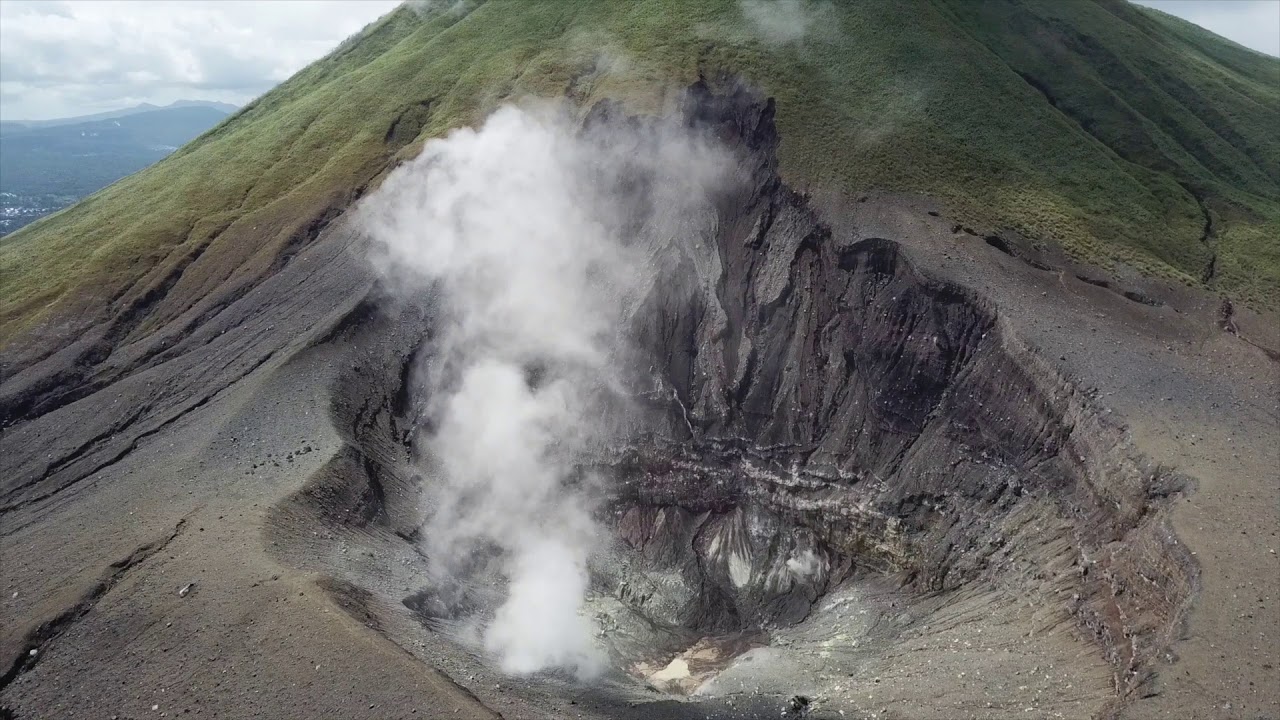
The Lokong-Empung volcanic complex, rising above the plain of Tondano in North Sulawesi, includes four peaks and an active crater. Lokon, the highest peak, has a flat craterless top. The morphologically younger Empung cone 2 km NE has a 400-m-wide, 150-m-deep crater that erupted last in the 18th century. A ridge extending 3 km WNW from Lokon includes the Tatawiran and Tetempangan peaks. All eruptions since 1829 have originated from Tompaluan, a 150 x 250 m crater in the saddle between Lokon and Empung. These eruptions have primarily produced small-to-moderate ash plumes that sometimes damaged croplands and houses, but lava-dome growth and pyroclastic flows have also occurred.
Source : GVP , PVMBG.
Photo : lumbalumba resort , Manado
Colombia , Purace / Chaine volcanique Los Coconucos :
Weekly bulletin of the activity of the Puracé volcano – Los Coconucos volcanic chain
Monitoring the activity of the PURACE VOLCANO – LOS COCONUCOS VOLCANIC CHAIN, the MINISTRY OF MINES AND ENERGY through the COLOMBIAN GEOLOGICAL SERVICE (SGC)
reports:
During the week between September 5 and 11, 2023, seismic activity showed a similar trend to that observed in previous weeks, maintaining values above the baseline of historical activity, both in energy released than in number of events recorded. Seismic events linked to the movement of fluids in volcanic conduits predominated, located mainly under the crater of the Puracé volcano.
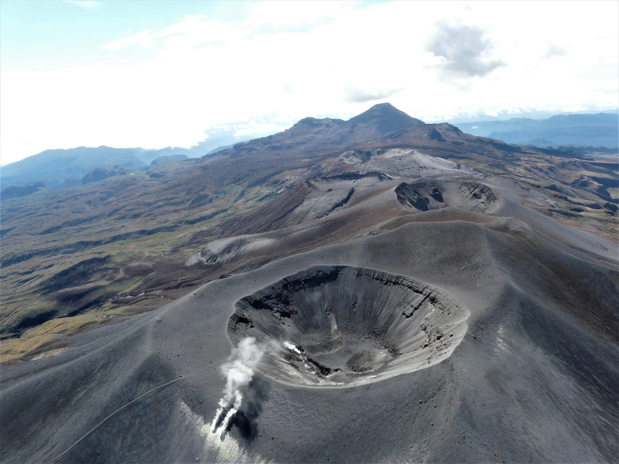
This activity was accompanied by localized deformations in the upper part of the volcanic chain. In addition, stable values were recorded in the flow of sulfur dioxide (SO2) and high values in the concentration of carbon dioxide (CO2) compared to what was recorded in the second half of 2022.
The other parameters measured and used for the diagnosis of volcanic activity showed no notable changes during the period evaluated.
The activity level of the volcano remains at the level:
YELLOW LEVEL (III): CHANGES IN THE BEHAVIOR OF VOLCANIC ACTIVITY
Source et photo : SGC