September 10 , 2023.
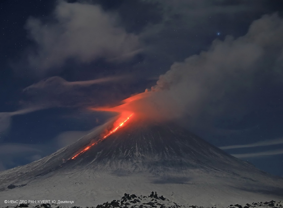
Kamchatka , Klyuchevskoy :
VOLCANO OBSERVATORY NOTICE FOR AVIATION (VONA)
Issued: September 09 , 2023
Volcano: Klyuchevskoy (CAVW #300260)
Current aviation colour code: ORANGE
Previous aviation colour code: yellow
Source: KVERT
Notice Number: 2023-97
Volcano Location: N 56 deg 3 min E 160 deg 38 min
Area: Kamchatka, Russia
Summit Elevation: 4750 m (15580 ft)
Volcanic Activity Summary:
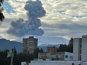
Video cameras and satellite data by KVERT show a strong wind lifts ash from the easthern slopes of Klyuchevskoy and Ushkovsky volcanoes (Sheveluch’s ash from April 10-13, 2023 eruption), and a plume of resuspended ash is extending about 330 km to the east and northeast of the volcanoes. The width of the ash strip in the area of volcanoes is 40 km and 70 km in the area of Cape Kamchatsky.
The summit explosive-effusive eruption of the volcano continues. Ash explosions up to 6 km (19,700 ft) a.s.l. could occur at any time. Ongoing activity could affect low-flying aircraft.
Volcanic cloud height:
2500-4000 m (8200-13120 ft) AMSL Time and method of ash plume/cloud height determination: 20230909/2210Z – Himawari-9 14m15
Other volcanic cloud information:
Distance of ash plume/cloud of the volcano: 330 km (205 mi)
Direction of drift of ash plume/cloud of the volcano: E / azimuth 88 deg
Time and method of ash plume/cloud determination: 20230909/2210Z – Himawari-9 14m15
Remarks: resuspended ash
Source : Kvert.
Photo : Yu. Demyanchuk, IVS FEB RAS, KVERT
Italy , Campi Flegrei :
SEISMOLOGY
The Campi Flegrei Permanent Seismic Network is made up of 27 land and sea stations. The permanent marine multiparametric monitoring and experimental research infrastructure that operates in the Gulf of Pozzuoli, called MEDUSA, is made up of 4 geodetic buoys (CFBA, CFBB, CFBC and CFSB) and as many underwater modules equipped with geophysical, oceanographic and multiparametric instrumentation. Currently, the CFSB station is not functional.
During the month of August 2023, 1118 earthquakes were recorded in the Campi Flegrei (Mdmax=3.6±0.3; event of 08/18/2023 at 04:18 UTC).
435 of the recorded events occurred during 5 seismic swarms:
● the first, from 21:44 UTC on 08/12/2023, composed of 19 earthquakes with -0.1≤Md≤1.2 (±0.3), occurring in the Pozzuoli Accademia area;
● the second, from 22:17 UTC on 08/15/2023, composed of 26 earthquakes with -0.8≤Md≤1.3 (±0.3), occurring in the Pozzuoli Solfatara area;
● the third, from 08:14 UTC on 08/16/2023, composed of 14 earthquakes with -0.8≤Md≤1.6 (±0.3), occurring in the Pozzuoli area;
● the fourth, from 23:57 UTC on 08/17/2023, composed of 292 earthquakes with -1.1≤Md≤3.6 (±0.3), occurring in the Solfatara, Pisciarelli, Accademia area ;
● the fifth, from 02:48 UTC on 08/21/2023, composed of 84 earthquakes with -0.8≤Md≤2.4 (±0.3), occurring in the Pozzuoli region.
The earthquake Md=3.6(±0.3) of 08/18/2023 UTC is currently, with the earthquakes of 06/11/2023 at 06:44 UTC and 03/29/2022 at 17:45 UTC, the highest energy event recorded since the resumption of this bradyseismic phase began in 2005, and all three events are also the highest energy events recorded since 1985.
The number of earthquakes recorded during the month of August 2023 is currently the highest number of events/month recorded since the resumption of this bradyseismic phase that began in 2005.
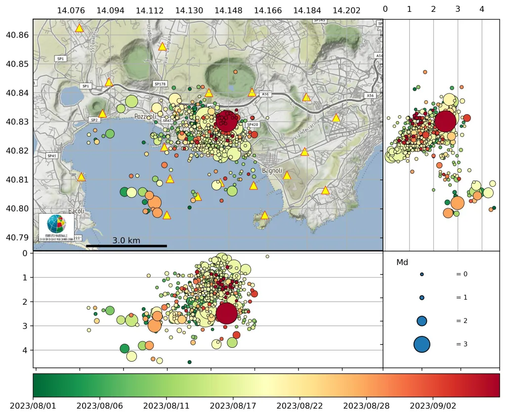
The main seismo-genetic zone, from the crisis of the 80s, is between Pozzuoli, Solfatara, Pisciarelli and Agnano, with events also present in the Gulf of Pozzuoli since 2018. Depths rarely exceed 4 km.
The last major event (19:45 on September 7, 2023) occurred in the Solfatara region at a depth of 2.5 km and had an amplitude (Md) equal to 3.8, it is currently the most energetic in the bradyseismic phase which has taken place since the end of 2005, currently in progress. This event was seen not only in the Campi Flegrei region, but throughout the city of Naples. The characteristics of the event as well as the mechanism of extensional rupture are similar to those observed for most events that took place in the Campi Flegrei region, especially the most energetic ones.
Ground deformation
The rising area is centered on the Rione Terra (Pozzuoli, historic part) or a little further south, and has a radial deformation, rapidly attenuating towards the periphery of the caldera, with a « bell » shape. The values local deformations are measured through a dense GNSS and tiltmetric network, integrated with satellite observations. Since 2005, and particularly during the last periods, the form of deformation has remained similar, testifying that the process, and especially the source, does not present no significant changes.
Since January 2023, the average value of the lifting speed in the maximum deformation zone is approximately 15±3 mm/month, with slight variations, such as that recorded from the end of May to the end of June 2023.
The cause of the uprising
The latest seismic swarms, including that of September 7, 2023, show that the phenomenon does not present substantial changes, even if it occurs with pulsations that repeat over time. The cause of ground heaving and thus seismicity may be due to a large increase in gas and greater pressurization of the deep hydrothermal system. Another possibility is that magmatic tongues fed by the deep magma system, called sill structures, about 3 to 4 km deep, are injected into the basement. The origin of the uplift is therefore linked to the upward thrust generated by the installation of fluids or magmatic pins, and the resulting crowning generates an arc and an elongation of the overlying crust with consequent fractures and faults which generate earthquakes and facilitate the rise of hydrothermal fluids.
Source : INGV / https://buff.ly/3LaLZNd
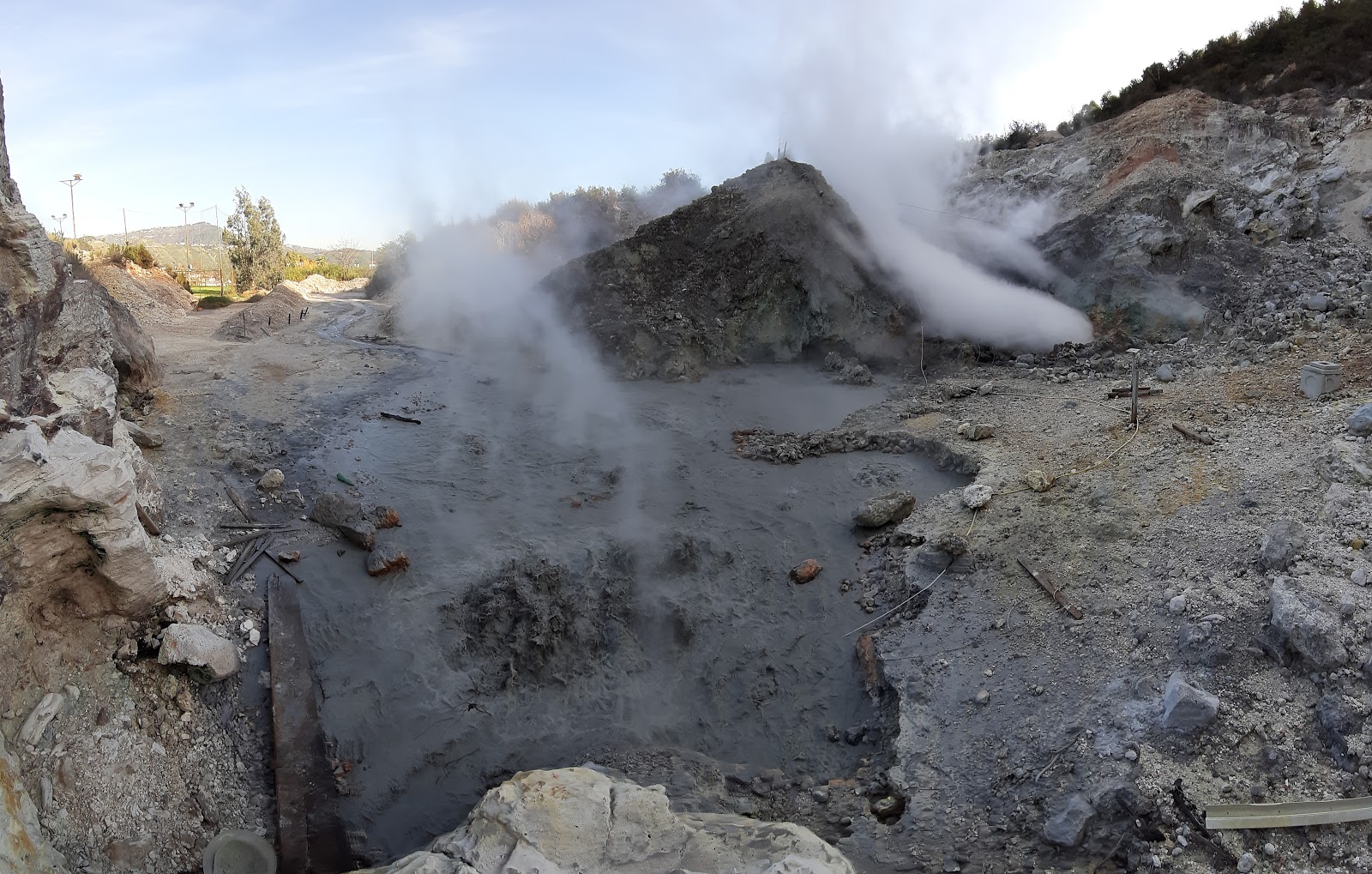
Photos : INGV , Pisciarelli , Tullio Ricci, décembre 2019.
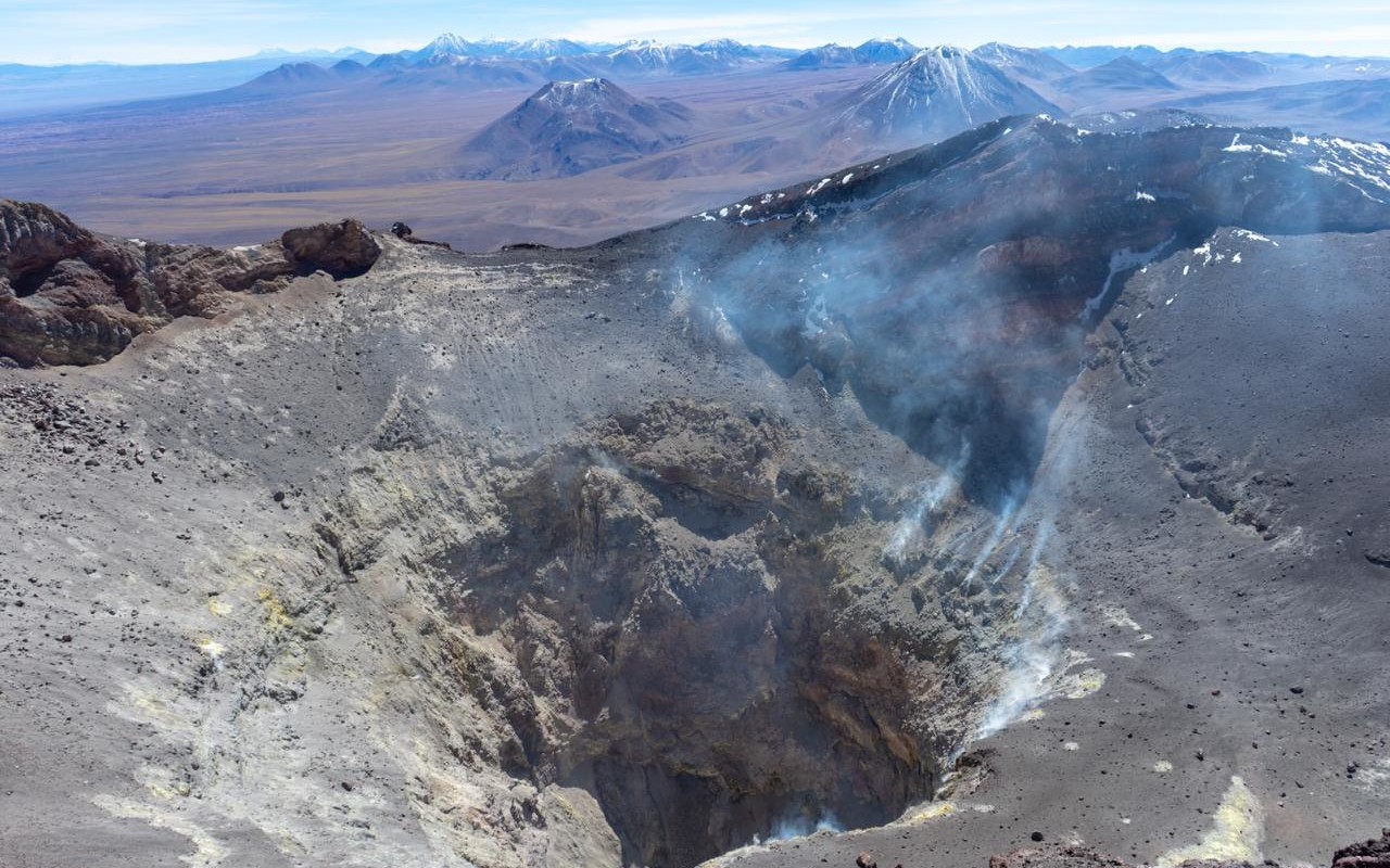
Chile , Lascar :
Seismology
The seismological activity of the period was characterized by the recording of:
59 seismic events of type VT, associated with the fracturing of rocks (Volcano-Tectonics). The most energetic earthquake had a Local Magnitude (ML) value equal to 1.4, located 0.9 km east-northeast of the volcanic edifice, at a depth of 2.4 km relative to to the crater.
81 LP type seismic events, associated with fluid dynamics inside the volcanic system (Long Period type). The size of the largest earthquake evaluated from the Reduced Displacement (RD) parameter was equal to 12 cm2.
4 TR type seismic events, associated with the dynamics maintained over time of fluids inside the volcanic system (TRemor). The size of the largest earthquake evaluated from the Reduced Displacement (RD) parameter was equal to 4 cm2.
Fluid geochemistry
Sulfur dioxide (SO2) emissions data obtained by the Differential Optical Absorption Spectroscopy (DOAS) equipment, corresponding to the Emú station, located 6 km in the east-southeast (ESE) direction of the active crater, presented an average value of 527 ± 61 t/d, with a maximum daily value of 737 t/d on August 31.
Thermal anomalies by satellites
During the period, no thermal alert was recorded in the area associated with the volcanic complex, according to data processed by the Mid-Infrared Observation of Volcanic Activity (MIROVA). In addition, no radiance anomalies were reported thanks to the analytical processing of Sentinel 2-L2A satellite images, in combination of false color bands.
Geodesy
From the geodetic data obtained during the period, very small amplitude changes can be observed in the vertical displacements, not exceeding 0.2 cm/month in the station closest to the volcano. On the other hand, the lengthening of the tracking line would have stopped, showing a rate of variation which would indicate a slight shortening, worth 0.25 cm/month. Thanks to radar interferometry, no signal is detected in the middle and far field of the volcanic edifice which could be linked to volcanic deformation.
Surveillance cameras
During most of the fortnight, passive and low-energy degassing was observed, with a maximum height of 480 m on August 20. We notice a decrease in degassing, which was observed sporadically and even absent, despite favorable observation conditions, between August 23 and 28.
Satellite geomorphological analysis
Thanks to the observation of Planet Sope Scene and Sentinel 2 L2A satellite images, no significant morphological change was observed during the fortnight. The observation of fluctuating degassing from the internal walls of the crater continues. At the same time, morphologies associated with internal gravitational collapses are maintained.
During this period, the increase in seismic activity associated with fluid dynamics stands out, highlighting the recording of certain low energy tremor type signals. Compared to sulfur dioxide (SO2) fluxes, the values remain in a range considered low and similar, at the surface, with passive and pulsatile degassing. No signs of processes associated with the deformation of the volcanic system. Due to the above, the volcanic system is indicated to have evidence of near-surface processes that still have the potential to generate minor explosions,
YELLOW TECHNICAL ALERT: Changes in the behavior of volcanic activity
Source : Sernageomin
Photo : Vulcanopro.
Ecuador , Reventador :
DAILY REPORT ON THE STATE OF THE REVENTADOR VOLCANO, Saturday September 9, 2023.
Information Geophysical Institute – EPN.
Surface activity level: High, Surface trend: No changes
Internal activity level: Moderate, Internal trend: No changes
Seismicity: From September 8, 2023, 11:00 a.m. to September 9, 2023, 11:00 a.m.:
The following table shows the number of seismic events from the reference station in the last 24 hours.
Explosion (EXP) 26
Long Period (LP) 19
Transmitting Tremor (TREMI) 21
Harmonic Tremor (TRARM) 44
Volcano-tectonic (VT): 1
Rains / Lahars:
There are no reports of rain. “In the event of heavy rains, these could remobilize the accumulated materials, generating mud and debris flows which would flow down the flanks of the volcano and flow into adjacent rivers.”
Emissions/ash column:
Due to weather conditions, a clear observation of the volcano has no longer been possible since yesterday, with the exception of a gas emission less than 300 m above the level of the crater, in a North-North-East direction. .
Other monitoring parameters:
Thanks to the SENTINEL satellite system, 1 thermal anomaly was recorded over the last 24 hours.
Observation:
Since yesterday, thanks to the surveillance camera system, it has been possible to see that the volcano remains cloudy most of the time, with the exception of yesterday afternoon when we were able to observe the lower part of the volcano and momentarily the summit. On the other hand, during the night, two episodes of incandescence were recorded at the level of the crater with falls of material up to 400 m on the southern flank.
Alert level: Orange.
Source : IGEPN.
Photo : Henry Vasconez
Mexico , Popocatepetl :
September 9, 11:00 a.m. (September 9, 5:00 p.m. GMT)
Activity from the last 24 hours
46 exhalations were detected, accompanied by water vapor, volcanic gases and sometimes ash.
In addition, 190 minutes of high-frequency tremors of medium to low amplitude were recorded, accompanied by an emission of water vapor, gas and ash, which dispersed in a West-South-West direction.
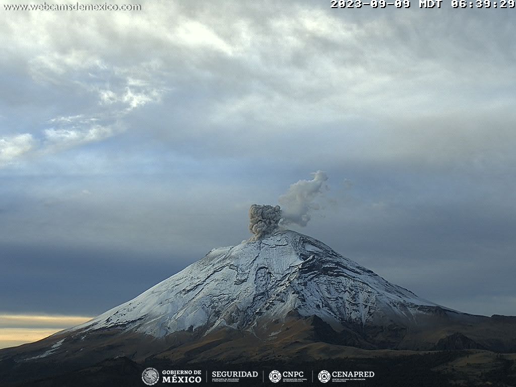
During the morning and at the time of this report, a constant emission of water vapor and volcanic gases was observed in a West-South-West direction.
Following this activity, the National Center for Communications and Civil Protection Operations (CENACOM) reported ash falls in the municipality of Ayala, Morelos state.
The volcanic warning fire of the Popocatépetl volcano is in yellow phase 2.
Source : Cenapred.