February 11 , 2024 .
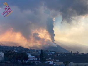
Indonesia , Marapi :
An eruption of Mount Marapi occurred on Saturday, February 10, 2024 at 4:51 p.m. WIB with the height of the ash column observed at ± 700 m above the summit (± 3591 m above sea level). The ash column was observed to be white to gray in color with thick intensity, oriented towards the South-West. This eruption was recorded on a seismograph with a maximum amplitude of 5 mm and a duration of 50 seconds.
VOLCANO OBSERVATORY NOTICE FOR AVIATION – VONA
Issued : February 10 , 20240210/0951Z
Volcano : Marapi (261140)
Current Aviation Colour Code : ORANGE
Previous Aviation Colour Code : orange
Source : Marapi Volcano Observatory
Notice Number : 2024MAR002
Volcano Location : S 0 deg 22 min 52 sec E 100 deg 28 min 23 sec
Area : West Sumatra, Indonesia
Summit Elevation : 9251 FT (2891 M)
Volcanic Activity Summary :
Eruption with volcanic ash cloud at 09h51 UTC (16h51 local).
Volcanic Cloud Height :
Best estimate of ash-cloud top is around 11491 FT (3591 M) above sea level or 2240 FT (700 M) above summit. May be higher than what can be observed clearly. Source of height data: ground observer.
Other Volcanic Cloud Information :
Ash cloud moving to southwest. Volcanic ash is observed to be white to gray. The intensity of volcanic ash is observed to be thick.
Remarks :
Eruption recorded on seismogram with maximum amplitude 5 mm and maximum duration 50 second. Tremor recorded on seismogram with maximum amplitude 2 mm.
Source : Magma Indonésia.
Photo : Sumatera Barat Indonesia
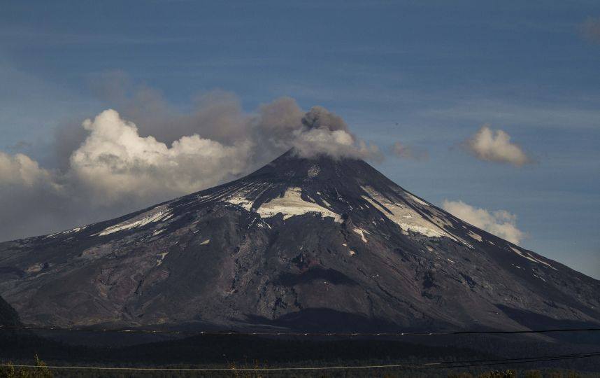
Chile , Lascar :
Seismology
The seismological activity of the period was characterized by the recording of:
23 seismic events of type VT, associated with the fracturing of rocks (Volcano-Tectonics). The most energetic earthquake had a Local Magnitude (ML) value equal to 2.3, located 2.9 km south-southwest of the volcanic edifice, at a depth of 6.5 km from the crater .
43 LP type seismic events, associated with fluid dynamics inside the volcanic system (Long Period). The size of the largest earthquake evaluated from the Reduced Displacement (RD) parameter was equal to 11 cm2. No event presented the minimum energy to be localized.
1 TR type seismic event, associated with the dynamics maintained over time of fluids inside the volcanic system (TRemor). The size of the earthquake evaluated from the Reduced Displacement (RD) parameter was equal to 1 cm2. No event presented the minimum energy to be localized.
Fluid geochemistry
The sulfur dioxide (SO2) emissions data obtained by the differential optical absorption spectroscopy (DOAS) equipment, corresponding to the Emú station, located 6 km in the East-South-East (ESE) direction from active crater, presented an average value of 157 ± 40 t/d, with a maximum daily value of 402 t/d on January 9. No anomalies have been reported in emissions of sulfur dioxide (SO2) into the atmosphere in the area near the volcano, according to data published by the Tropospheric Monitoring Instrument (TROPOMI).
![]()
Thermal anomalies by satellites
During the period, thermal alerts were recorded in the area associated with the volcanic system, according to data processed by Middle Infrared Observation of Volcanic Activity (MIROVA), with a maximum power < 1 MW. on January 21. No thermal alert was recorded in the area associated with the volcanic edifice, according to the analytical processing of Sentinel 2-L2A satellite images, in combination of false color bands.
Geodesy
Geodetic activity was characterized by:
– Small-scale trips.
– Deformation rate not exceeding 0.26 cm/month in vertical components and 0.17 cm/month in horizontal components.
In conclusion, there is no evidence of deformation of the volcanic system for the period evaluated.
Surveillance cameras
The images provided by the fixed camera, installed near the volcano, recorded regular degassing, with a maximum column height of 2,400 meters on January 4.
Activity remained at levels considered low, suggesting stability of the volcanic system. The technical volcanic alert is maintained in:
GREEN TECHNICAL ALERT: Active volcano with stable behavior – There is no immediate risk
Source : Sernageomin
Photos : Sernageomin / Gabriel Orozco .
Chile , Villarica :
Special Report on Volcanic Activity (REAV), La Araucanía and Los Ríos regions, Villarrica volcano, February 11, 2024, 02:10 a.m. local time (mainland Chile)
The National Geology and Mining Service of Chile (Sernageomin) announces the following PRELIMINARY information, obtained through the monitoring equipment of the National Volcanic Monitoring Network (RNVV), processed and analyzed at the Southern Andean Volcano Observatory (Ovdas):
On Sunday February 11, 2024, at 1:50 a.m. local time (04:50 UTC), monitoring stations installed near the Villarrica volcano recorded an earthquake associated with fluid dynamics inside the volcanic system (volcano-tectonic type).
The characteristics of this earthquake after its analysis are as follows:
ORIGINAL TIME: 01:50 local time (04:50 UTC)
REDUCED TRAVEL: 71.84 (cm*cm)
ACOUSTIC SIGNAL: 4.3 Pascals (Pa) reduced to 1 km
Observation :
No superficial activity associated with this event was recorded.
The technical volcanic alert is maintained at YELLOW level.
Source : Sernageomin
Photos : auteur inconnu.
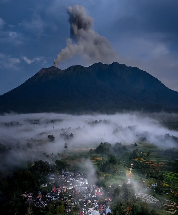
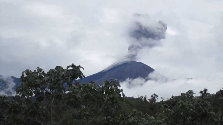
Ecuador , Reventador :
DAILY REPORT ON THE STATE OF THE REVENTADOR VOLCANO, Saturday February 10, 2024.
Information Geophysical Institute – EPN.
Surface activity level: Moderate, Surface trend: No changes
Internal activity level: Moderate, Internal trend: No changes
Seismicity: From February 9, 2024, 11:00 a.m. to February 10, 2024, 11:00 a.m.:
The following table shows the number of seismic events from the reference station in the last 24 hours.
Explosion (EXP) 28
Long Period (LP) 16
Transmitting tremor (TREMI) 12
Tremor Harmonic (TRARM): 6
Precipitation/Lahars:
Rainfall is not recorded. **In the event of heavy rains, these could remobilize the accumulated materials, generating mud and debris flows which would descend the sides of the volcano and flow into adjacent rivers.
Emissions/ash column:
Due to weather conditions, it was not possible to observe gas or ash emissions, either through the camera system or through the GOES-16 satellite system. In contrast, the VAAC agency in Washington has not published emissions reports over the period of this report.
Observation:
Since yesterday afternoon, the volcano has remained cloudy most of the time. At night, the surveillance camera recorded the release of incandescent material, which descended along the slopes up to 500 meters below the summit level. At the time of publication of this report, the sector is completely cloudy.
Alert level: Orange.
Source : IGEPN.
Photo : auteur inconnu.
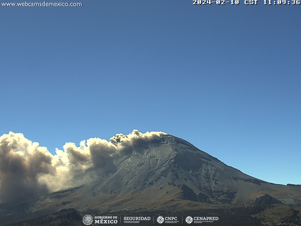
Mexico , Popocatepetl :
February 10, 11:00 a.m. (February 10, 5:00 p.m. GMT)
Activity from the last 24 hours
34 exhalations accompanied by water vapor, volcanic gases and ash were detected. Additionally, 764 minutes of high-frequency, low-amplitude tremors were identified.
During the morning and at the time of this report, a continuous emission of volcanic gases and ash is observed, with dispersion towards the North-North-East (NNE).
The volcanic warning fire of the Popocatépetl volcano is in yellow phase 2.
The scenarios planned for this phase are:
A few small to moderate explosions
Appearance of tremors of variable amplitude
Source et photo : Cenapred.