June 17 , 2023.
Hawaii , Kilauea :
Friday, June 16, 2023, 7:30 AM HST (Friday, June 16, 2023, 17:30 UTC)
19°25’16 » N 155°17’13 » W,
Summit Elevation 4091 ft (1247 m)
Current Volcano Alert Level: WATCH
Current Aviation Color Code: ORANGE
Activity Summary:
Kīlauea volcano is erupting. Eruptive activity is confined to Halemaʻumaʻu crater within the summit caldera at Kīlauea. No unusual activity has been noted along the volcano’s East Rift Zone or Southwest Rift Zone.
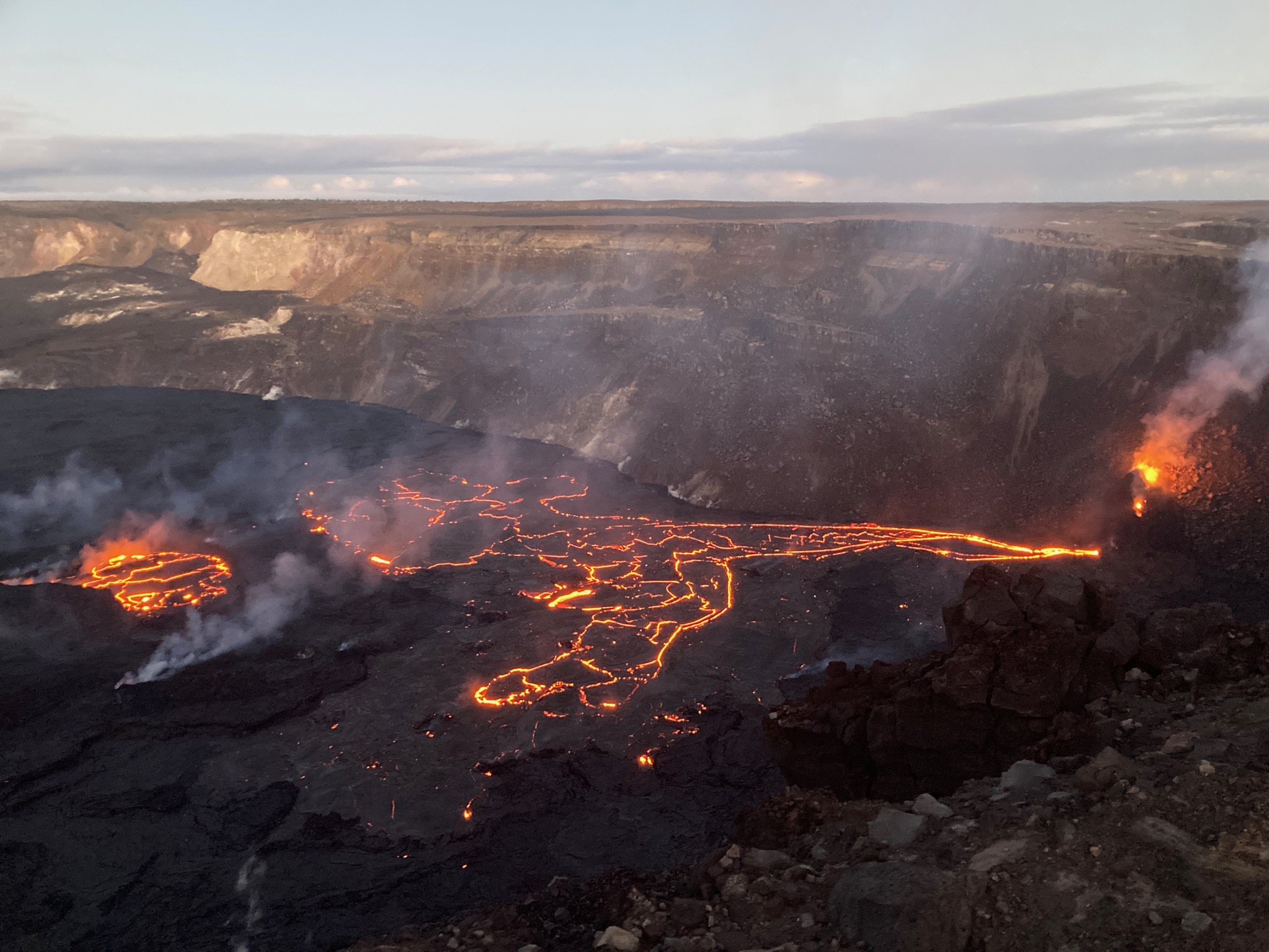
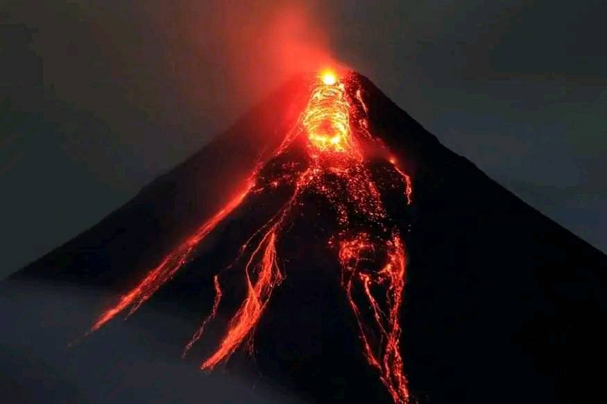
An overview of eruptive activity in Halemaʻumaʻu crater at the summit of Kīlauea during the evening of Wednesday, June 14, 2023. The eruptive vent in the southwest wall of the crater (right) appeared to be the only active vent, and it was supplying lava into a lake in the southwestern portion of the crater.
Halemaʻumaʻu crater Eruption Observations:
The eruptive vent in the southwest wall of Halemaʻumaʻu continues effusing into the lava lake in the far southwestern portion of the crater. Around 8:00 a.m. yesterday morning, the very top of the spatter cone at this vent collapsed. Since then, spattering from the vent has been renewed and nearly constant, while several new lava streams have effused from the top of the cone in addition to the preexisting tube-fed flow from its base. This morning, a partial diversion in this flow from the base has been overflowing lava onto the southwestern-most block from the 2018 collapse within Halemaʻumaʻu. No other eruptive vents are active at this time.
The surface of the southwestern lava lake continues to circulate and is slowly rising, along with the rest of the crater floor, which is uplifting endogenously from lava accumulation below the solidified crust. Lava circulation also continues within the central basin that became the focus of effusion during both the 2021–2022 and January–March 2023 eruptions, although the lava level within it has been dropping relative to the surrounding crust. Several overflows from the southwestern lava lake even cascaded into the central basin last night and early this morning. No active lava has been observed in the northern or eastern portions of the crater over the past day.
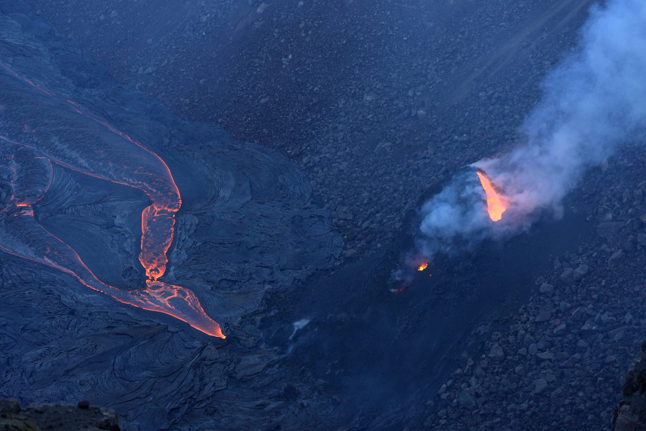
A view of the eruptive vent in the southwest wall of Halemaʻumaʻu crater, taken from the western caldera rim at Kīlauea on Wednesday, June 14, 2023. Visible is the vent opening at the top of the perched cone and lava effusing from its base onto the crater floor.
Summit Observations:
Tiltmeters in the summit region have tracked slight deflationary tilt over the past day. Summit seismic activity is dominated by eruptive tremor—a signal resulting from fluid movement, and commonly associated with eruptive activity. Volcanic gas emissions in the area remain elevated; a sulfur dioxide (SO2) emission rate of approximately 4,800 tonnes per day was measured yesterday, Thursday, June 15.
Rift Zone Observations:
No unusual activity has been noted along the East Rift Zone or Southwest Rift Zone; steady but low rates of ground deformation and seismicity continue along both. Measurements from continuous gas monitoring stations in the middle East Rift Zone—the site of 1983–2018 eruptive activity—remain below detection limits for SO2.
Source : HVO.
Photo : USGS / M. Patrick
Indonesia , Merapi :
Report on the activity of Mount Merapi from June 09, 2023 to June 15, 2023, Published on June 16, 2023
RESULTS OF OBSERVATIONS
Visual
The weather around Mount Merapi is usually sunny in the morning and afternoon, while the evening is foggy. White, fine to thick, low to medium pressure, 200 m high white smoke was observed from the Mount Merapi de Selo observation post on June 14, 2023 at 5:43 p.m.
This week, lava avalanches were observed 119 times to the southwest (upstream of Kali Bebeng) with a maximum slip distance of 2000 m. The sound of the avalanches was heard 55 times from the Babadan post with low to medium intensity.
On the Southwest dome, morphological changes have been observed due to lava avalanches. For the central dome, no significant morphological change was observed. Based on the results of a drone survey on May 17, 2023, the measured volume of the Southwest dome was 2,372,800 m3 and the central dome was 2,337,300 m3.
Seismicity
This week, the seismicity of Mount Merapi showed:
1 deep volcanic earthquakes (VTB),
780 avalanche earthquakes (RF),
13 tectonic earthquakes (TT).
25 multi-phase (MP) earthquakes
2 low frequency (LF) earthquakes.
In general, the intensity of seismicity this week is higher than last week.

Deformation
Mount Merapi’s deformation that was monitored using EDM and GPS this week showed a shortening rate of 0.1 cm/day.
Rain and lahars:
This week there was rainfall at the Mount Merapi observation post with a rain intensity of 8 mm/h for 30 minutes at the Kaliurang post on June 12, 2023.
Conclusion
Based on the results of visual and instrumental observations, it is concluded that:
-The volcanic activity of Mount Merapi is still quite high in the form of effusive eruption activity. The state of the activity is defined at the « SIAGA » level.
The current danger potential is in the form of lava avalanches and hot clouds in the South-South-West sector comprising the Boyong River for a maximum of 5 km, the Bedog, Krasak, Bebeng rivers for a maximum of of 7 km. In the South-East sector, it includes the Woro River for a maximum of 3 km and the Gendol River for 5 km. While the ejection of volcanic material in the event of an explosive eruption can reach a radius of 3 km from the summit.
Source : BPPTKG
Photo : imamismadin
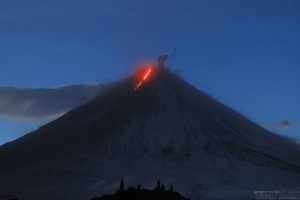
Philippines : Mayon :
MAYON VOLCANO BULLETIN: 17 June 2023 8:00 AM
In the past 24-hour period, very slow effusion of lava from the summit crater of Mayon Volcano continued to feed lava flows and collapse debris on the Mi-isi (south) and Bonga (southeastern) gullies. The lava flows have advanced to maximum lengths of one thousand five hundred (1500) meters from the summit crater while collapse debris have deposited to three thousand three hundred (3300) meters from the crater. A total of nine (9) dome-collapse pyroclastic density currents (PDC) that lasted two (2) to four (4) minutes, two-hundred eighty (280) rockfall events, and two (2) volcanic earthquakes were recorded by the Mayon Volcano Network.
Continuous moderate degassing from the summit crater produced steam-laden plumes that rose 100 m before drifting to the general west. Sulfur dioxide (SO2) emission averaged 978 tonnes/day on 16 June 2023. Short-term observations from EDM and electronic tiltmeter monitoring show the upper slopes to be inflating since February 2023. Longer-term ground deformation parameters based on EDM, precise leveling, continuous GPS, and electronic tilt monitoring indicate that Mayon is still inflated, especially on the northwest and southeast.
Alert Level 3 is maintained over Mayon Volcano, which means that it is currently in a relatively high level of unrest as magma is at the crater and hazardous eruption within weeks or even days is possible.
Source : Phivolcs
Photo : Lan Po Lan
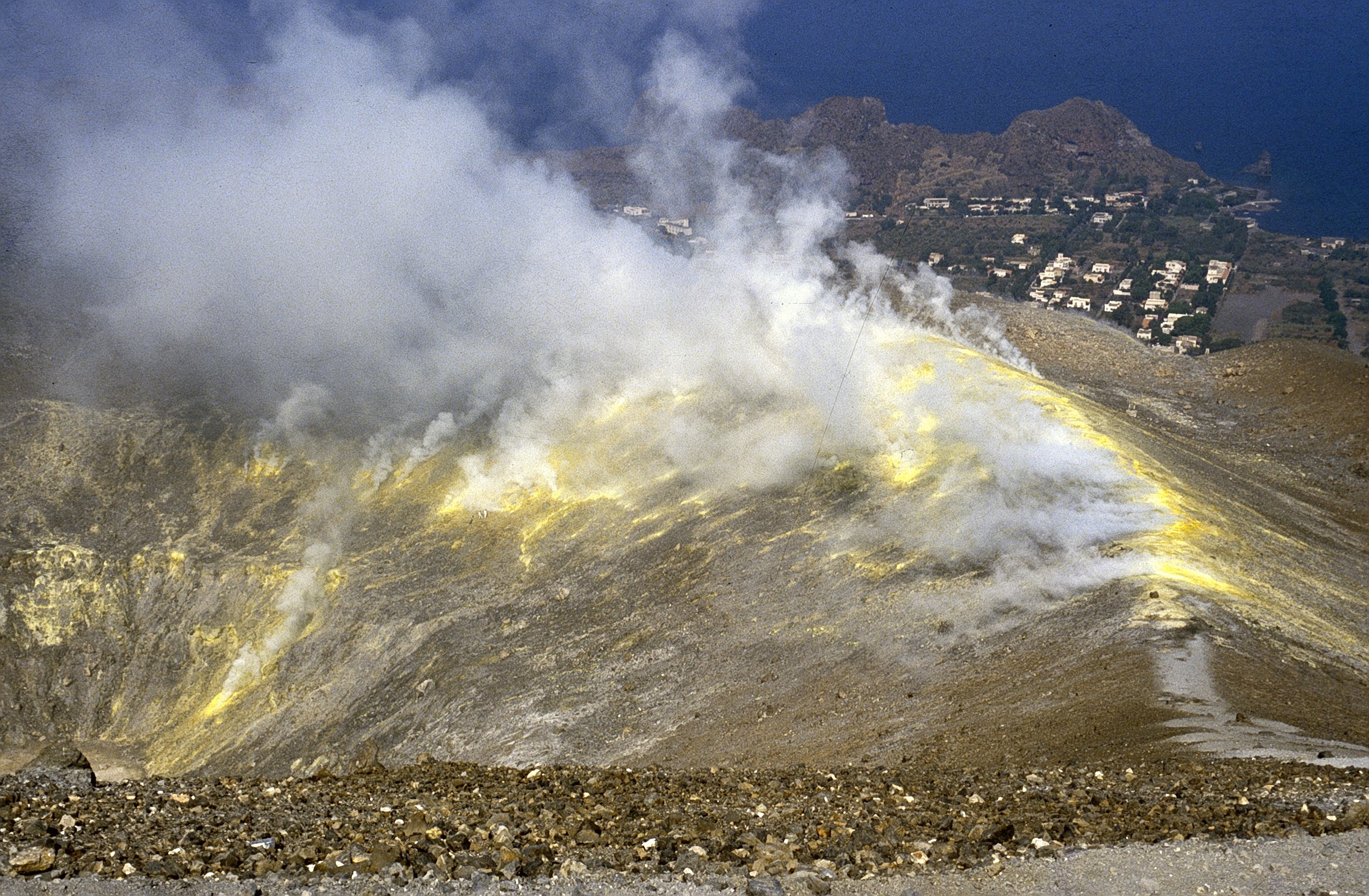
Italy , Vulcano :
WEEKLY BULLETIN, from June 05, 2023 to June 11, 2023. (issue date June 13, 2023)
ACTIVITY STATUS SUMMARY
In the light of the monitoring data, it is highlighted:
1) Temperature of the crater fumaroles: The temperatures recorded on the edge of the crater are stable at high values.
2) CO2 flux in the crater area: There are no updates.
3) SO2 flux in the crater area: at an average level
4) Geochemistry of fumarolic gases: There are no new updates. The data from the last sampling (05/11/2023) show constant magmatic species concentration values on the average values; the isotopic ratio of helium does not show any significant variations.
5) CO2 fluxes at the base of the La Fossa cone and in the Vulcano Porto area: The CO2 fluxes recorded at the sites of Rimessa, C. Sicilia show stable values, always above background levels. At the P4max site, the flows increase slightly to high levels, while at the Faraglione site, values close to the background level are recorded.
6) Geochemistry of thermal aquifers: stable but still high temperature values are recorded in the Camping Sicilia well and no variation in conductivity values; in the Bambara well the water conductivity remains at high values.
7) Local seismicity: moderate increase in the rate of occurrence of local micro-shocks with a spectral peak greater than 1 Hz. Stationarity of low frequency events.
8) Regional seismicity: No earthquakes with a local magnitude equal to or greater than 1.0 were recorded.
9) Deformations – GNSS: The GNSS network does not show significant variations.
10) Deformations – Inclinometry: The inclination of the sensor does not show any significant variations.
11) Gravimetry: No significant change was recorded.
LOCAL SEISMICITY
During the week considered, the phase of increasing local micro-shocks with a spectral peak above 1 Hz continued. Regarding lower frequency events (mainly VLP; spectral peak below 1 Hz), the rate of occurrence remained at levels comparable to those of the previous week. However, the scale of the events and the overall level of activity remain low.
Source : INGV.
Photo : Boris Behncke
Costa Rica , Poas / Rincon de la Vieja :
Poas Volcano
latitude: 10.20°N; Longitude: 84.23°W;
Altitude: 2687m
Current activity level: warning
A variable volcanic tremor signal with a broad frequency spectrum and small low frequency LP-type volcanic earthquakes are maintained, all associated with surface hydrothermal activity. Geodetic observations show a contraction of the top of the volcano. During the past week, a SO2 flux of 241 +/- 47 t/d has been calculated.
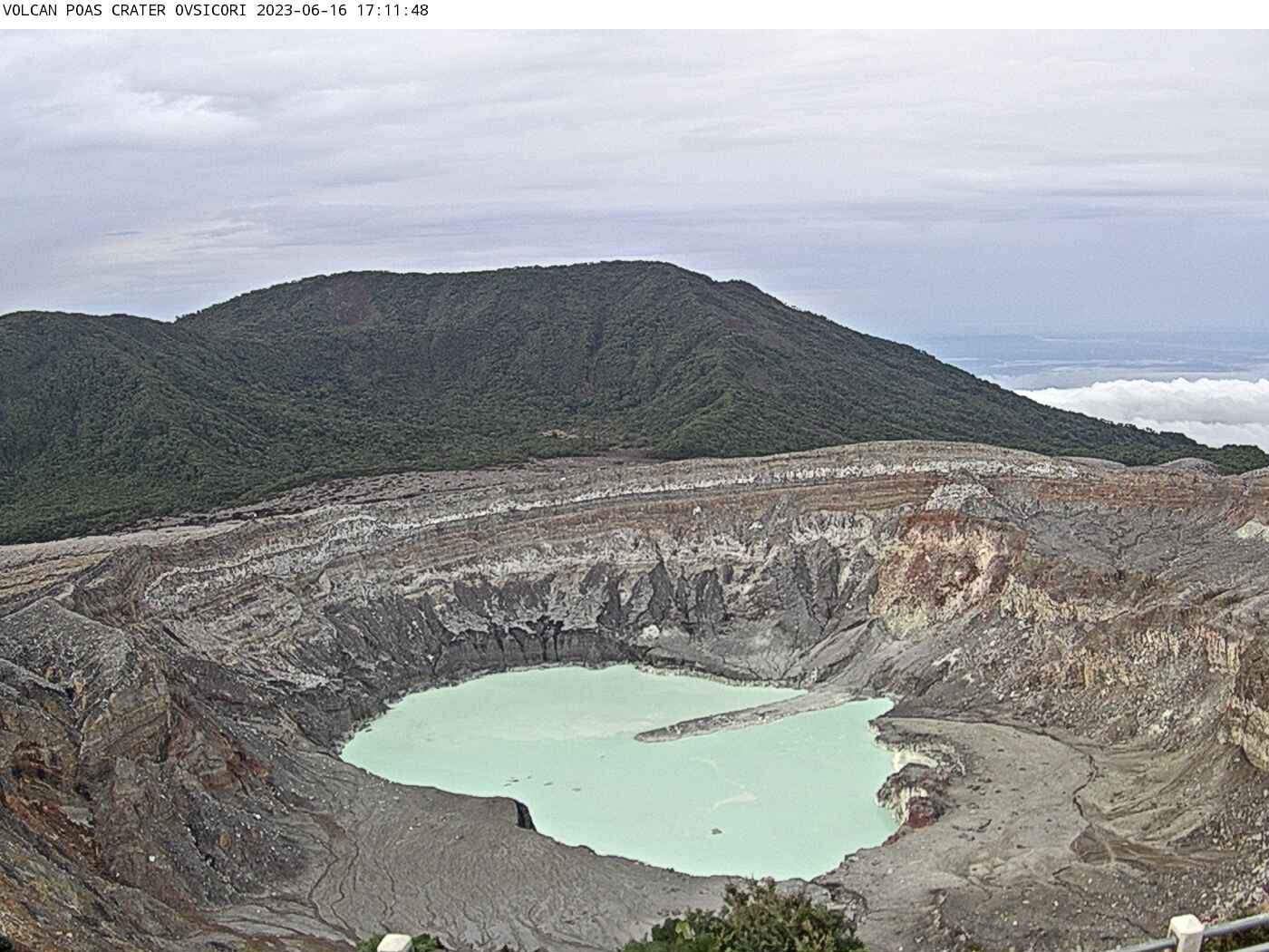
The gas ratios measured in the plume remain similar to the previous week with weekly averages of SO2/CO2 = 0.86 +/- 0.18 and H2S/SO2 = 0.011 +/- 0.004. The concentration of SO2 in the ambient air around the lookout ranged from 0 ppm to 7.2 ppm this week. The level of the lake began to fall again, decreasing by 40 cm and reaching a level of 2328 m on June 15, 2023. The temperature of the lake was measured at 49°C on June 13 (direct measurement with thermocouple).
Rincon de la Vieja Volcano
latitude: 10.83°N; Longitude: 85.34°W;
Altitude: 1916m
Current activity level: warning
Last week, 13 eruptions between small and moderate were recorded, the largest expelled a column of gas and water vapor that reached 2,500 meters above sea level, however, none of them succeeded to expel material from the lake, so no lahars caused by eruptions have been recorded. Two types of tremors with different frequency bands are recorded, one between 1 and 3 Hz and the second between 4 and 6 Hz. Low frequency and low amplitude volcanic earthquakes of the LP type continue to be recorded, as well as small distal volcano-tectonic earthquakes of the VT type, fracture of rocks in faults located south of the volcano.

Geodetic measurements detect an uplift of the summit of the volcanic massif less important than in recent weeks. But a new slight extension of the base is detected. Gas ratios measured in fumarolic emissions from the crater remain within the range observed in previous weeks, with weekly averages of CO2/SO2 = 4.8+/- 3.5 and H2S/SO2 = 0.06 +/- 0 ,04. During the past week, the SO2 flux was 113 +/- 95 t/d. The ash emitted on April 21, 2023 consists mainly of rock fragments and altered and secondary minerals (gypsum, sulfur, silica, iron sulphides) with a very low juvenile glass content.
Source : Ovsicori.
Photos : Ovicori , Federico Chavarría-Kopper – Ovsicori