January 11 , 2023.
Italy / Sicily , Etna :
WEEKLY BULLETIN, from January 02, 2023 to January 08, 2023. (issue date 10 January 2023)
ACTIVITY STATUS SUMMARY
In the light of the monitoring data, it is highlighted:
1) VOLCANOLOGICAL OBSERVATIONS: Effusive activity with lava flows in Valle del Leone and Valle del Bove, variable rate degassing at the summit craters.
2) SEISMOLOGY: Low seismic activity linked to fracturing processes. The average amplitude of the volcanic tremor was set at medium or medium-low levels; the centroids of the sources are located, until January 5, between the effusive vent and the Southeast crater and thereafter to the Northwest of the latter.
3) INFRASOUND: Low activity related to infrasound events; the springs were located in the area of the Bocca Nuova crater.
4) GROUND DEFORMATIONS: During the last week, the ground deformation monitoring networks have not recorded any significant variations.
5) GEOCHEMISTRY: SO2 flux at a medium-low level.
The soil CO2 flux values recorded last week are average values.
The CO2 of the water table (EtnaAcque Network) presents variations which are part of the seasonal variability of the site. Helium isotopes (sampling): there are no updates.
6) SATELLITE OBSERVATIONS: The thermal activity observed by satellite in the summit zone was of a high level in correspondence with the effusive eruption in the summit zone.
VOLCANOLOGICAL OBSERVATIONS
During the week of observation, monitoring of Etna’s volcanic activity was carried out through the analysis of images from the network of INGV surveillance cameras, Osservatorio Etneo (INGV-OE) and at through some observations made by volcanological guides and reliable external sources.
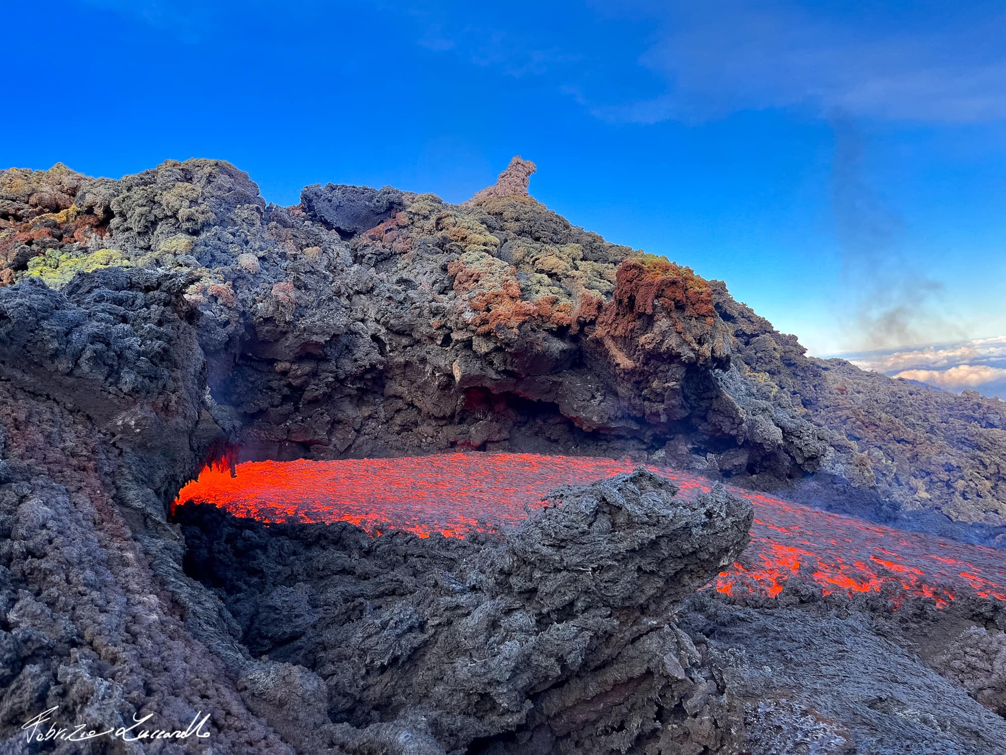
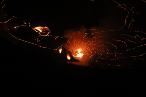
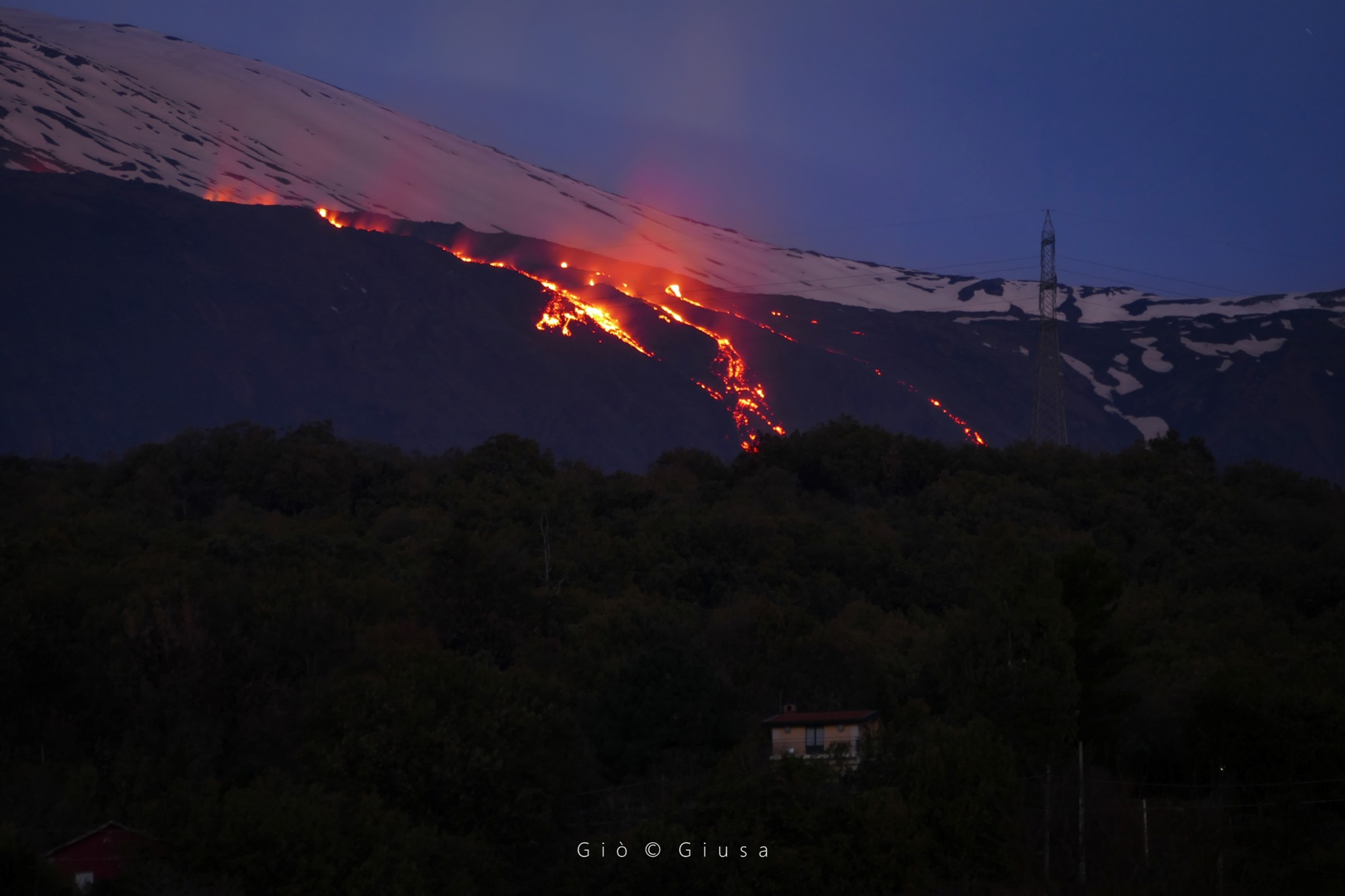
During the observation period, the effusive activity that began on November 27, 2022 from the vent that opened at the northeast base of the Southeast crater at an altitude of approximately 2800 m is continued. The activity had, as already described in the previous weeks, a variable effusive regime and continued to form a lava field characterized by the overlapping of different lava flows with an expansion in the Valle del Leone and the Valle del Bove. From the analysis of ESA Sentinel Hub images from January 2, 4 and 7, it was possible to determine that the most advanced lava front is at an altitude of approximately 2170 m. As of January 7, 2023, the preliminary estimate of the area of the lava field is approximately 6.3 x 10^5 m^2 while that of the total volume is approximately 2.5 – 4.3 x 10^ 6 m^3 (estimated error is about 40%) .
Observations during inspections also found that the lava field is very complex and frayed with the formation of hornitos and tunnels.
Finally, with regard to the summit craters, the activity was characterized by a variable rate degassing mainly by the Bocca Nuova
Source : INGV.
Photos : Gio Giusa , Fabrizio Zuccarello .
Hawaii , Kilauea :
Tuesday, January 10, 2023, 8:50 AM HST (Tuesday, January 10, 2023, 18:50 UTC)
19°25’16 » N 155°17’13 » W,
Summit Elevation 4091 ft (1247 m)
Current Volcano Alert Level: WATCH
Current Aviation Color Code: ORANGE
Activity Summary:
The summit eruption of Kīlauea Volcano, within Halemaʻumaʻu crater, continued over the past 24 hours. All recent eruptive activity has been confined to the crater. No significant changes have been observed at the summit or in either rift zone.
Halemaʻumaʻu Lava Lake Observations:
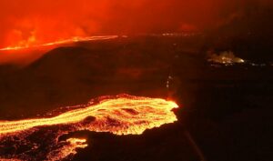
Eruption of lava from vents on the central eastern portion of Halemaʻumaʻu crater floor continued over the past 24 hours. Activity is concentrated in the eastern half of the crater and within the basin in the western half of the crater that was the focus of activity in 2021–2022. The active lava area in the eastern half of the crater has one dominent fountain, and the active area has shrunk over the past 24 hours.
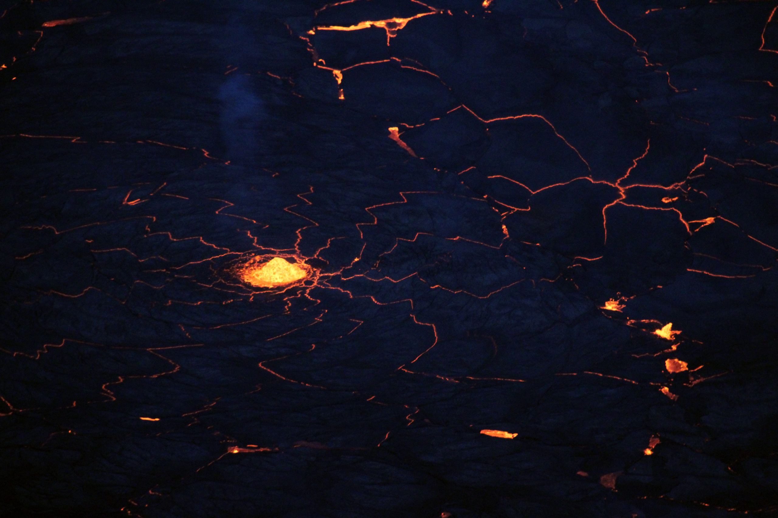
Telephoto view of the most active lava fountain during a helicopter overflight of the current eruption within Halema‘uma‘u, Kīlauea, taken on January 8, 2023. This fountain is within the eastern half of Halema‘uma‘u. The red cracks that emanate from the fountain, giving the appearance of a spider’s web, indicate that lava is moving radially away from the fountain in all directions.
Summit Observations:
Over the past 24 hours, summit tiltmeters recorded deflation until early this morning, and are now recording inflation. Volcanic tremor remains above background levels. A sulfur dioxide (SO2) emission rate of approximately 3,500 tonnes per day (t/d) was measured yesterday, January 9, 2023.
Rift Zone Observations:
No unusual activity has been noted along the East Rift Zone or Southwest Rift Zone; low rates of ground deformation and seismicity continue along both. Measurements from continuous gas monitoring stations downwind of Puʻuʻōʻō in the middle East Rift Zone remain below detection limits for SO2, indicating that SO2 emissions from Puʻuʻōʻō are negligible.
Source : HVO.
Photo : USGS / N. Deligne.
Italy , Stromboli :
WEEKLY BULLETIN, from January 02, 2023 to January 08, 2023. (issue date 10 January 2023)
ACTIVITY STATUS SUMMARY
In the light of the monitoring data, it is highlighted:
1) VOLCANOLOGICAL OBSERVATIONS: During this period, normal Strombolian activity was observed with intense spattering activity accompanied by two lava overflows at the level of the North crater area. The total hourly frequency oscillated between low (5 winds/h) and medium-low (9 events/h) values.
The intensity of the explosions was mainly medium to low in the area of the North crater and medium and high in the area of the Center-South crater.
2) SEISMOLOGY: The seismological parameters do not show significant variations.
3) SOIL DEFORMATIONS: The island’s soil deformation monitoring networks did not show any significant variation to report for the period considered.
4) GEOCHEMISTRY: The flow of SO2 at an average level.
CO2 flux in the crater area: there are no updates; the latest measurements from 10.12.2022 show a downward trend while remaining on medium-high values.
CO2/SO2 ratio: the CO2/SO2 ratio displays medium-high values, equal to 13.82 (data validated on 08.01.2023).
Isotope ratio of dissolved Helium in heat sinks: there are no updates.
5) SATELLITE OBSERVATIONS: The thermal activity observed from the satellite was generally weak. High heat flux values were observed on January 3, 2023 in correspondence with the lava overflow in the summit area.
VOLCANOLOGICAL OBSERVATIONS:
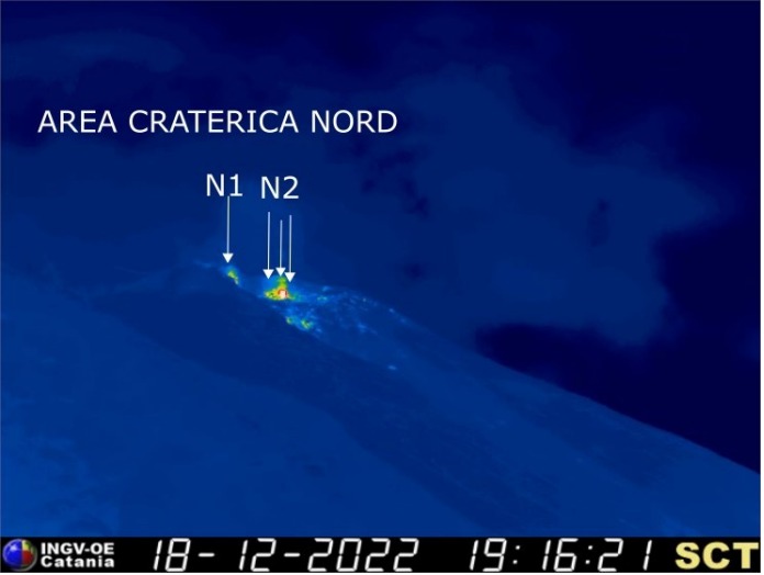
The explosive activity was mainly produced by 4 (four) eruptive vents located in the North zone of the crater and by one located in the Center-South zone. The mouths of the North crater zone are located in the upper part of the Sciara del Fuoco while the mouth of the Center-South zone is located inside the crater terrace.
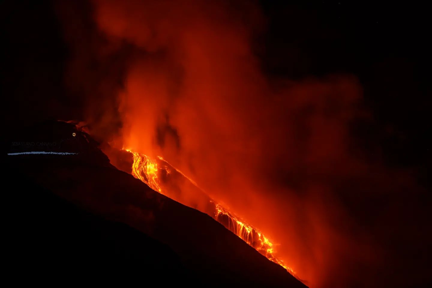
On January 2 and 4, 2023, two lava overflows were emitted from the North Zone vents extending into the central-upper part of the Sciara del fuoco.
Observations of explosive activity captured by surveillance cameras
In the northern area of the crater (N), explosive and effusive activity was observed only from the vents located inside the Sciara del Fuoco in its upper part after the collapse of the northern rim. The four vents showed explosive activity (explosions of varying intensity from weak (less than 80 m high) to strong (more than 150 m high) emitting coarse materials (bombs and lapilli)) and effusive (lava flow which reached the middle part of the Sciara). In addition, intense spattering activity was observed throughout the period both from the vent located near sector N1 and from those located near sector N2. The average frequency of explosions varied from 3 to 8 events/h. In the Center-South (CS) zone, explosive activity of medium and high intensity was observed (sometimes the products exceeded 250 in height) emitting fine materials (ash) mixed with coarse materials. The frequency varied between 1 and 4 events/h.
Flows on January 2 and 4, 2023.
On January 02, 2023 starting at 20:36 UTC after intense spattering activity from the northern vents of the crater terrace near sector N2, an overflow of lava occurred which began to flow in the upper middle part of the crater. Sciara, likely channeling into the Canyon produced on October 9, 2022, so not visible to surveillance cameras. The lava flow was weakly fed at the source and after a few hours appeared poorly fed and cooling. On January 04, 2023 from 01:24 UTC after intense spattering activity from the northern vents of the crater terrace near sector N2, an overflow of lava occurred which began to flow in the middle-upper part of the Sciara, probably channeling into the Canyon of October 9, 2022, therefore not visible by surveillance cameras.
The lava flow was well fed at source and after a few hours appeared low fed and cooled.
Source : INGV.
Photos : INGV , Sebastiano Cannavo / Stromboli stati d’animo.
Indonesia , Marapi / Kerinci :
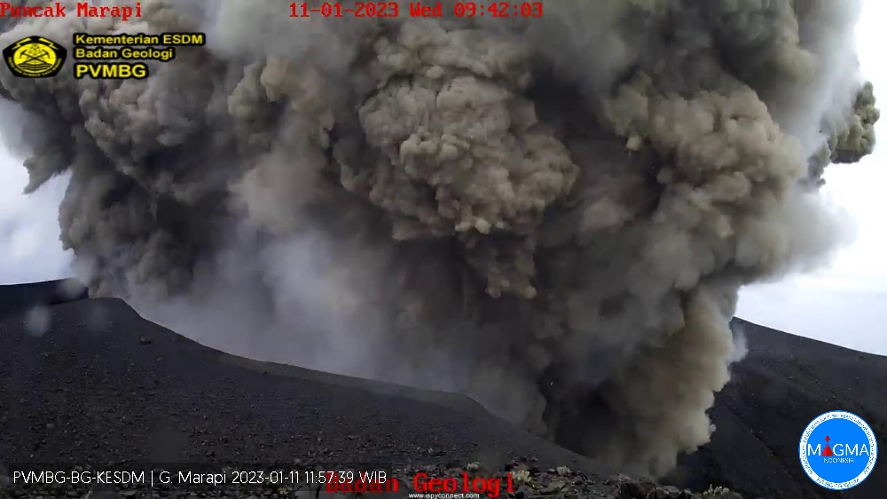
An eruption of G. Marapi occurred on Wednesday January 11, 2023 at 11:33 a.m. WIB with an ash column height observed at ± 400 m above the summit (± 3291 m above sea level). The ash column was observed to be white/gray with a thick intensity, oriented to the East and Southeast. At the time of writing this report, the eruption was still ongoing.
VOLCANO OBSERVATORY NOTICE FOR AVIATION – VONA
Issued : January 11 , 2023
Volcano : Marapi (261140)
Current Aviation Colour Code : ORANGE
Previous Aviation Colour Code : orange
Source : Marapi Volcano Observatory
Notice Number : 2023MAR021
Volcano Location : S 0 deg 22 min 52 sec E 100 deg 28 min 23 sec
Area : West Sumatra, Indonesia
Summit Elevation : 9251 FT (2891 M)
Volcanic Activity Summary :
Eruption with volcanic ash cloud at 04h33 UTC (11h33 local).
Volcanic Cloud Height :
Best estimate of ash-cloud top is around 10531 FT (3291 M) above sea level or 1280 FT (400 M) above summit. May be higher than what can be observed clearly. Source of height data: ground observer.
Other Volcanic Cloud Information :
Ash cloud moving from east to southeast. Volcanic ash is observed to be white to gray. The intensity of volcanic ash is observed to be thick.
Remarks :
Eruption and ash emission is continuing.
————————————————————————————————–
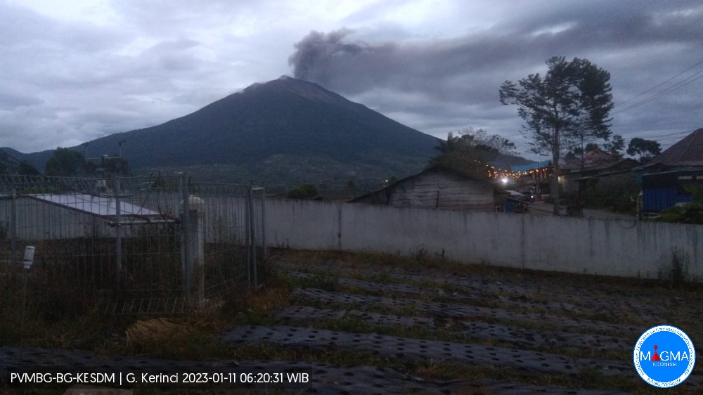
An eruption of Mount Kerinci occurred on Wednesday January 11, 2023 at 05:46 WIB with the height of the ash column observed at ± 900 m above the summit (± 4705 m above sea level). The ash column was observed to be gray with a thick intensity oriented northeast and east. At the time of writing this report, the eruption was still ongoing.
VOLCANO OBSERVATORY NOTICE FOR AVIATION – VONA
Issued : January 10 , 2023
Volcano : Kerinci (261170)
Current Aviation Colour Code : ORANGE
Previous Aviation Colour Code : unassigned
Source : Kerinci Volcano Observatory
Notice Number : 2023KER001
Volcano Location : S 01 deg 41 min 49 sec E 101 deg 15 min 50 sec
Area : Jambi, West Sumatra, Indonesia
Summit Elevation : 12176 FT (3805 M)
Volcanic Activity Summary :
Eruption with volcanic ash cloud at 22h46 UTC (05h46 local).
Volcanic Cloud Height :
Best estimate of ash-cloud top is around 15056 FT (4705 M) above sea level or 2880 FT (900 M) above summit. May be higher than what can be observed clearly. Source of height data: ground observer.
Other Volcanic Cloud Information :
Ash cloud moving from northeast to east. Volcanic ash is observed to be gray. The intensity of volcanic ash is observed to be thick.
Remarks :
Eruption and ash emission is continuing.
Source et photos : Magma Indonésie.
Chile , Tupungatito :
Special report on volcanic activity (REAV), Santiago Metropolitana region, Tupungatito volcano, September 07, 2022, 7:06 p.m. local time (mainland Chile).
The National Service of Geology and Mines of Chile (Sernageomin) publishes the following PRELIMINARY information, obtained through the monitoring equipment of the National Volcanic Monitoring Network (RNVV), processed and analyzed at the Volcanological Observatory of the Southern Andes ( Ovdas):
On Tuesday January 10, 2023, at 3:31 p.m. local time (6:31 p.m. UTC), the monitoring stations installed near the Tupungatito volcano recorded an earthquake associated with the fracturing of rocks (volcano-tectonic type) in the volcanic system.
The characteristics of earthquakes after their analysis are as follows:
ORIGINAL TIME: 3:31 p.m. local time (6:31 p.m. UTC)
LATITUDE: 33.391°S
LONGITUDE: 69.784°E
DEPTH: 14.1 km
LOCAL MAGNITUDE: 3.4 (ML)
COMMENTS:
Before the occurrence of the volcano-tectonic event, events of lower energy were recorded.
The volcanic technical alert remains at the Green level.
Source et photo : Sernageomin.