January 04 , 2021.
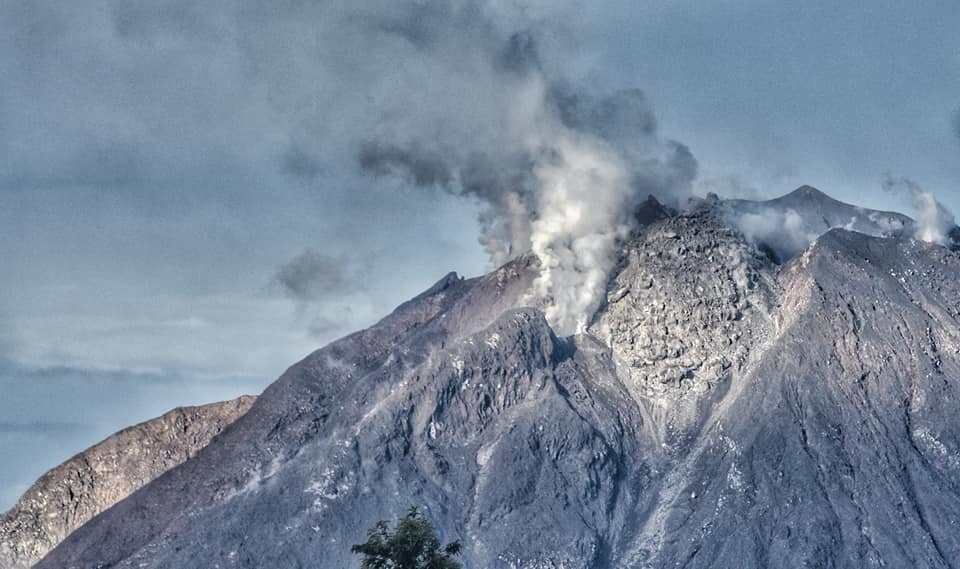
La Réunion , Piton de la Fournaise :
Seismicity
In December 2020, the OVPF recorded in the Piton de la Fournaise massif in total:
• 845 superficial volcano-tectonic earthquakes (0 to 2.5 km above sea level) below the summit craters;
• 3 deep earthquakes (below sea level);
• 357 collapses (in the Crater Dolomieu, the ramparts of the Enclos Fouqué and Piton de Crac, and the Rivière de l’Est).

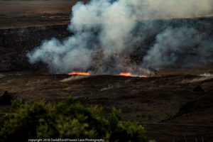
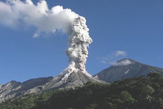
The volcano-tectonic activity under the Piton de la Fournaise in December 2020 will have been mainly marked by two seismic crises (on December 4 and 7) accompanying an intrusion (on the 4th), and preceding an eruption on the 7th with respectively 118 and 498 earthquakes. summits on December 4 and 7. These seismic crises were preceded by a slight resumption of the summit seismicity on December 3 (3 earthquakes). The first seismic crisis on December 4 (started at 5:10 a.m. local time), accompanied by deformations, did not result in surface activity but testified to an intrusion of magma towards the surface. Following this crisis, the seismicity remained high, prefiguring the crisis of December 7 (2:28 a.m. local time; 10:28 p.m. on December 6 in UTC time). This second crisis, accompanied by deformations much larger than those of December 4, was followed 2 hours and 12 minutes after its onset by the arrival of an eruptive tremor (4:40 local time), indicating the migration of magma near the surface.
This eruption lasted 26 hours and 35 minutes on the south-southwest flank of the terminal cone, until the eruptive tremor stopped on December 8 at 7.15 am local time (3.15 am UT). Following the end of the eruption on December 8, summit volcano-tectonic activity continued, with an average of two shallow volcano-tectonic earthquakes per day below the summit craters recorded between December 8 and 23. Subsequently, only two superficial volcano-tectonic earthquakes were recorded between December 24 and 31.
Deformation
The intrusion of December 4 and the eruption of December 7-8, 2020, were not preceded by marked inflation, in fact since the end of October a halt in inflation had been observed. Inflation only resumed in early December. The intrusion of December 4 was accompanied by very slight rapid deformations (<1cm). The most significant deformations (about 20 cm of elongation of the summit zone, and about 30 cm max near the eruptive cracks were associated with the second seismic crisis (on December 7) which resulted in the eruption of the December 7-8 on the flank
south southwest of the terminal cone.
Following the end of the eruption on December 8, inflation of the edifice was again observed with 3.1 cm elongation of the summit area recorded between December 8 and December 31. Note a slowdown in inflation around December 20.
Source : OVPF .
Read the article : http://www.ipgp.fr/sites/default/files/ovpf_20210104_bullmensu_compressed.pdf.
Photos : Imaz Press , Nath Duverlie .
Hawaii , Kilauea :
19°25’16 » N 155°17’13 » W,
Summit Elevation 4091 ft (1247 m)
Current Volcano Alert Level: WATCH
Current Aviation Color Code: ORANGE
Activity Summary:
Lava activity is confined to Halemaʻumaʻu with lava erupting from vents on the northwest side of the crater. Yesterday afternoon (Jan. 2), the lava lake was 190 m (623 ft) deep and perched about a meter (yard) above its edge. SO2 emission rates were still elevated.
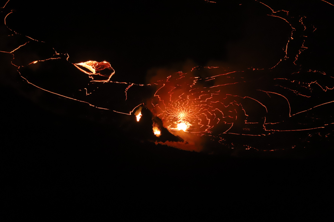
At Halema‘uma‘u, the west vents (visible in the foreground of this photo as two glowing holes on a cone-shaped feature) erupt occaisional spatter. Lava is also emerging in a small dome fountain above the lake crust in front of the west vents, probably from a submerged portion of the vent (visible in the background of this photo as a bright spot with lava crust boundaries emanating from it like a spider web). These processes can be observed in Kīlauea Volcano’s summit F1 thermal webcam view of the lava lake.
Summit Observations:
Sulfur dioxide emission rate measurements made Friday (Jan. 1) were about 4,400 t/d and in the range 3,000-6,500 t/d since Sunday (Dec. 27)–the same range of values that was common for the pre-2018 lava lake. Summit tiltmeters recorded weak deflationary tilt over the past two days. Seismicity remained elevated but stable, with steady elevated tremor and a few minor earthquakes.
East Rift Zone Observations:
Geodetic monitors indicate that the upper portion of the East Rift Zone (between the summit and Puʻu ʻŌʻō) contracted while the summit deflated. There is no seismic or deformation data to indicate that magma is moving into either of Kīlauea’s rift zones.
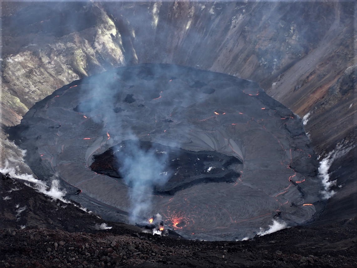
Over the past week, the lava lake in Halema‘uma‘u has developed a subtle levee around its perimeter that allows the lake to be slightly perched above its base, like a mesa. The levees grow from repeated small overflows, and the rafting and piling of pieces of surface crust that fuse together into a barrier that impounds the fluid lake. This is called a « perched » lava lake, and this geometry has been common for lava lakes at Kīlauea’s summit and rift zones.
Halemaʻumaʻu lava lake Observations:
The west vents spattered from two places at the top of a small cone plastered on the northwest wall of Halemaʻumaʻu crater. Lava is also emerging in a small dome fountain above the lake crust in front of the west vents probably from a submerged portion of the vent. Both of these sources can be seen in the thermal webcam view of the lava lake.
The lava lake was 190 m (623 ft) deep yesterday afternoon (Jan. 2). The most recent thermal map (Dec. 30) provided the lake dimensions as 800 by 530 m (875 by 580 yds) for a total area of 33 ha (82 acres) .The lake is now perched about a meter (yard) above its east and west edges and discontinuously on its north edge as measured this morning (Jan. 3).
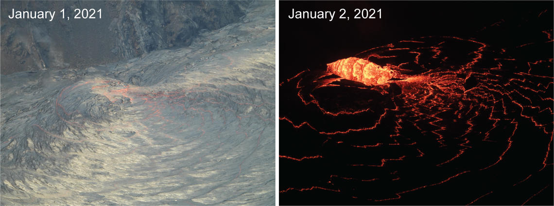
The west vent in Halema‘uma‘u crater continues to erupt at Kīlauea’s summit. These telephoto images from January 1 (left) and January 2 (right) compare the lava lake surface below the west vent. The west vent is supplying lava to the lake through a crusted over channel, which enters just below the lake surface. As the lava enters the lake, it produces localized upwelling at the surface. By January 2 there appears to be an increase in eruptive vigor where a small dome-like fountain is breaking through the surface crust.
Over the past day, the main island of cooler, solidified lava floating in the lava lake continued settling in front of the west lava source filling the lake around midnight, while the other 10 or so small islands remained relatively stationary around the east end of the lake. The main island measured about 250 m (820 ft) in length, 135 m (440 ft) in width, and about 3 ha (7 acres) in area based on the Dec. 30 thermal map. Measurements Friday afternoon (Jan. 1) showed that the island surface was about 6 m (20 ft) above the lake surface.
Source : HVO.
Photos : USGS photo by H. Dietterich. USGS photo by M. Patrick ( 2 X ).
Indonesia , Sinabung :
VOLCANO OBSERVATORY NOTICE FOR AVIATION – VONA.
Issued : January 04 , 2021
Volcano : Sinabung (261080)
Current Aviation Colour Code : ORANGE
Previous Aviation Colour Code : unassigned
Source : Sinabung Volcano Observatory
Notice Number : 2021SIN01
Volcano Location : N 03 deg 10 min 12 sec E 98 deg 23 min 31 sec
Area : North Sumatra, Indonesia
Summit Elevation : 7872 FT (2460 M)
Volcanic Activity Summary :
Eruption with volcanic ash cloud at 01h54 UTC (08h54 local).
Volcanic Cloud Height :
Best estimate of ash-cloud top is around 10112 FT (3160 M) above sea level, may be higher than what can be observed clearly. Source of height data: ground observer.
Other Volcanic Cloud Information :
Ash-cloud moving to west – northwest
Remarks :
Seismic activity is characterized by eruption volcanic event
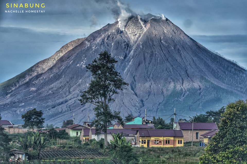
The activity level has been at level III (SIAGA) since May 20, 2019 at 10:00 a.m. WIB. Mount Sinabung (2460 m above sea level) has been erupting since 2013. The last eruption occurred on December 13, 2020 with a height of the eruption column that was not observed.
The volcano was clearly visible until it was covered in fog. An eruption occurred, causing a column of gray eruption, rising 1000 m above the summit of the summit crater, oriented to the northwest. When there is no eruption, the crater is observed to emit white smoke with a strong thickness about 50-500 meters above the summit. The weather is cloudy to rainy, with weak to moderate winds in the South, North-West, South-West and West. Avalanches were observed with a sliding distance of 1000 m to the east and south-east.
According to the seismographs of January 3, 2021, it was recorded:
2 eruption earthquakes
58 avalanche earthquakes
11 earthquakes of emissions
22 low frequency earthquakes
7 hybrid / multi-phase earthquakes
1 distant tectonic earthquake.
Source : Magma Indonésie , PVMBG.
Photos : Nachelle Homestay .
Guatemala , Santiaguito :
Activity:
The Observatory of the Volcanic Complex of Santa María-Santiaguito reports a white degassing column 500 meters high above the Caliente Dome which disperses to the southwest. During the night and early in the morning, explosions were observed which raised columns of ash up to 3,300 meters above sea level (11,827 feet) which moved a little over a kilometer to the southwest.
Due to the extrusion of block lava into the Caliente dome, avalanches of boulders and ash continue to be generated which descend mostly on the southwest flank, reaching the base of the dome. The possibility that this activity generates pyroclastic flows remains. Fine particles of ash fall on the perimeter of the domes. The recommendations of the special BESAN bulletin n ° 121-2020 remain in force
Source : Insivumeh .
Photo : la hora