
July 14 , 2018.
La Réunion , Piton de la Fournaise :
Activity Bulletin from Friday, July 13, 2018 at 16:30 (local time)
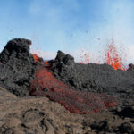
The eruption started on July 13, 2018 between 03:30 (beginning of the tremor recorded on the OVPF seismic stations) and 04:30 (first light visible on the OVPF’s webcams) continues (Figure 1). The intensity of the tremor (indicator of the eruptive intensity at the surface) is decreasing since its peak intensity phase recorded at 06:00 local time (02:00 UT time, Figure 1).
While the 4 eruptive fissures opened at the beginning of eruption were still active at 08:00 this morning, the most upstream crack (n ° 1) and the top of crack n ° 2 were no longer active at 12:30 pm (Figure 2).

Figure 1: Evolution of the RSAM (indicator of the volcanic tremor and the intensity of the eruption) between 20:40 (00:40 local time) and 11:30 (15:30 local time) on July 13 on the seismic station of BOR, located at the top.
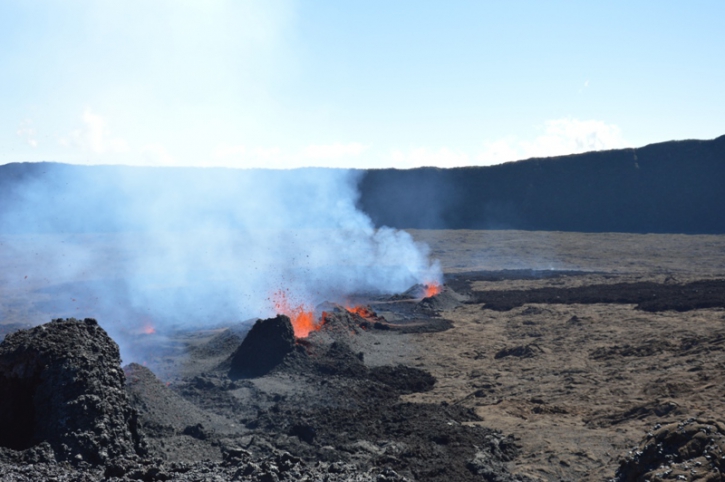
Figure 2: Shooting of the eruptive site on July 13, 2018 between 12:00 and 14:00 (local time). (© OVPF / IPGP)
The first measurements carried out in the field by an OVPF team made it possible to map more precisely the eruptive fissures and the advance of the flows (Figure 3). This mapping was made from images taken on the ground, and allowed to refine the aerial observations, but is still likely to evolve.
The propagation length of the 4 cracks has been revised downwards (500 m vs 1000 m in the aerial estimations). During this pedestrian reconnaissance, two downcomers, the most downstream, could be sampled.
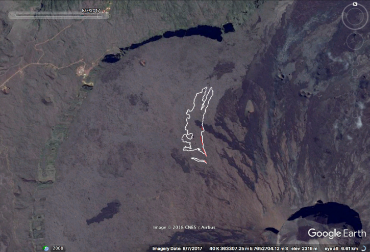
Figure 3: Location of eruptive cracks (red) and castings (white) at July 13 14:00 (local time). GoogleEarth background. (© OVPF / IPGP)
– No volcano-tectonic earthquake has been recorded since the beginning of the eruption.
– No significant deformities have been recorded since the beginning of the eruption.
– Estimated surface flows from satellite data, via the MIROVA platform (University of Turin), were included this morning between 2.88 and 5.34 m3 / s.
Alert Level: Alert 2-2: Eruption in the Enclos.

Activity Bulletin from Friday, July 13, 2018 to 23:00 (local time)
The eruption started on July 13, 2018 between 03:30 (beginning of the tremor recorded on the OVPF seismic stations) and 04:30 (first light visible on the OVPF webcams) local time stopped today, July 13 at 22:00 local time, after a phase of continuous decay of the tremor and about 3 hours of gas pistons (« gas flushes » typical of the eruptions of Piton de la Fournaise).
No more glare is visible on the OVPF webcams at the level of eruptive cracks, only a few glows remain perceptible at the level of uncooled casting front.
No assumptions are made about future developments in the near future (resumption of activity on the same site, resumption of activity elsewhere, permanent shutdown). Peak earthquakes are always recorded.
Alert level: Backup.
Source : OVPF
Chile , Nevados de Chillan :
Special Report on Volcanic Activity (REAV).
Del Bio Bio Region, C.V. Nevados de Chillan, 13 July 2018, 22:00 Local time (Continental Chile)
The National Geological and Mining Service of Chile (Sernageomin) publishes the following PRELIMINARY information, obtained through the monitoring equipment of the National Volcanic Monitoring Network (RNVV), processed and analyzed at the Volcanological Observatory of the Andes. South (OVDAS):
This July 13 at 20:55 local time (14 July 00:55 GMT), monitoring stations installed in the vicinity of the Nevados volcano of Chillan recorded an earthquake associated with an explosion driven by fluid dynamics inside the volcanic system, in the surroundings of the crater Nicador, 430 m deep.
The characteristics of the earthquake are as follows:
TIME OF ORIGIN: 20h55 Local time (14th of July 00h55 GMT)
LATITUDE: 36 ° 52.17 ‘S
LONGITUDE: 71 ° 22.32 ‘W
DEPTH: 0.43 km
LOCAL MAGNITUDE: 3.7 (ML)
ACOUSTIC SIGNAL: 17 Pa reduced to 1 km
REDUCED TRAVEL: 985 cm2
OBSERVATIONS:
This is the highest energy explosion recorded during this crisis. It is possible that this explosion destroyed part of the dome, emitting ballistic projectiles around the crater Nicanor, which could be corroborated by overflight.
The community near the volcano did not report any anomalies related to this event.
Weather conditions prevented the visual recording of the event.
At the time of publication of this report, there is no change in the seismic behavior of the volcano, which was confirmed later.
The technical alert level is maintained at the ORANGE level.
Source : Sernageomin.
Iceland , Öræfajökull :
Clear signs of unrest in Öræfajökull volcano
The Department of Civil and Emergency Management in Iceland have issued a new status for Öræfajökull volcano saying that it shows clear signs of unrest.
The department says in the statement that Öræfajökull volcano is showing clear signs of unrest with an inflation phase for at least a year and a half. The inflation is ongoing and it is reflected by increased seismic activity and characteristic deformation pattern. There are no signs of decrease in the inflation rate or the seismicity. The state of unrest persists despite a decrease in geothermal activity since last December.
The source causing the inflation is most likely injection of new magma. The volume change since the start of the unrest is of the order of magnitude of 10 million m3 (about 0.2 m3/sec) comparable to the intrusion activity in Eyjafjallajökull some years before the eruption in 2010
New resistivity measurements indicate the presence of geothermally altered rocks at shallow levels inside the caldera consistent with intermittent high temperature geothermal activity as seen in many other volcanoes
Scenarios and hazards:
Öræfajökull is in a typical preparation stage before an eruption but the temporal evolution and the outcome is unknown.
Increase in the geothermal activity with associated floods and gas release is a possible scenario
Source : Icelandmonitor.
Photo : mbl.is/RAX
Hawaï , Kilauea :
Friday, July 13, 2018, 10:35 AM HST (Friday, July 13, 2018, 20:35 UTC)
19°25’16 » N 155°17’13 » W,
Summit Elevation 4091 ft (1247 m)
Current Volcano Alert Level: WARNING
Current Aviation Color Code: ORANGE
Kīlauea Volcano Lower East Rift Zone
Fissure 8 continues to erupt lava into the perched channel leading northeastward from the vent. Lava levels in the upper channel between Fissure 8 and Pohoiki Rd. are low this morning but are expected to rise after the next collapse/explosive vent at Kīlauea summit.
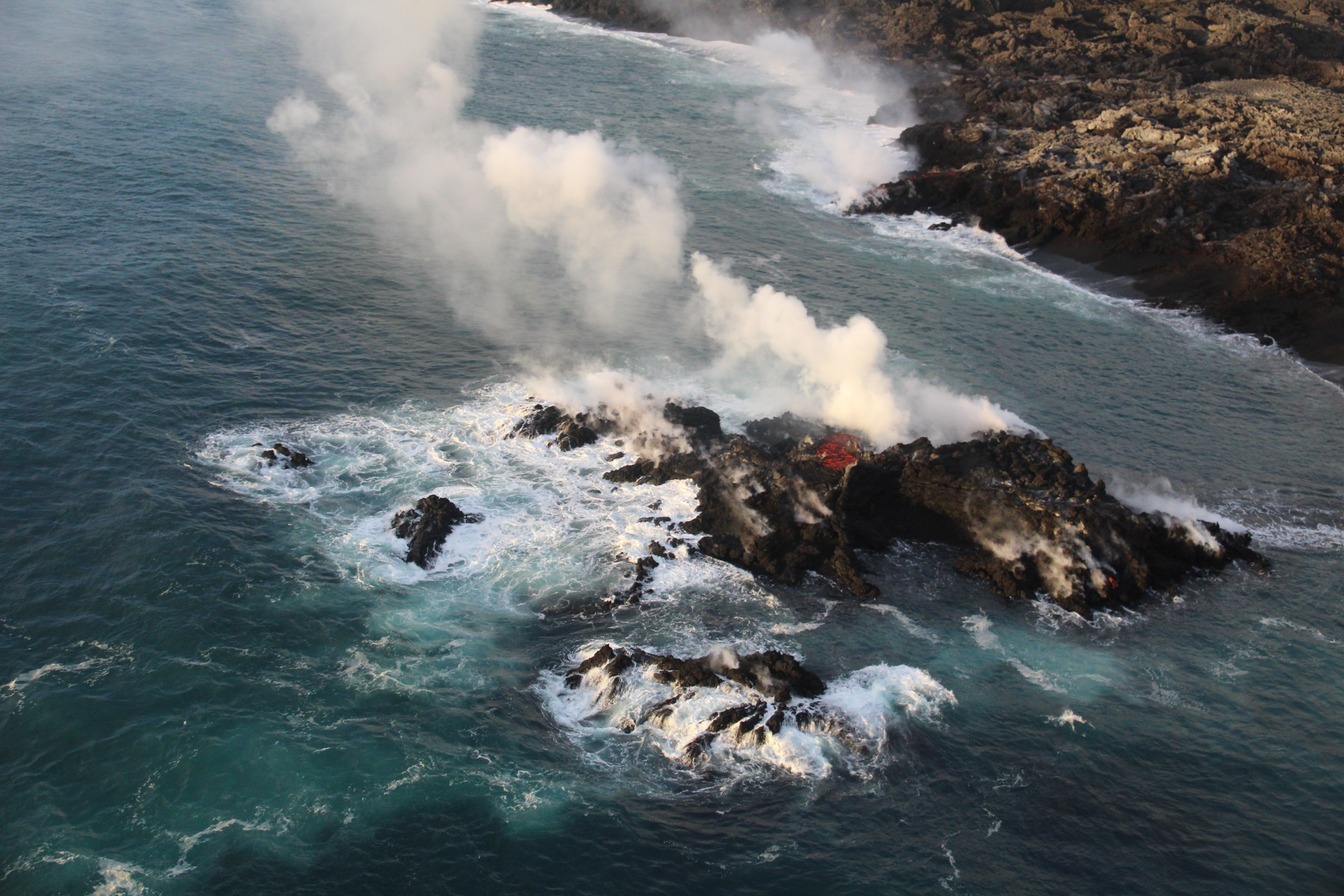
A closer view of the new « island, » which was estimated to be just a few meters offshore, and perhaps 6-9 meters (20-30 ft) in diameter. It’s most likely part of the fissure 8 flow that’s entering the ocean—and possibly a submarine tumulus that built up underwater and emerged above sea level.
The channelized ʻaʻā flow west of Kapoho Crater continues to be the main ocean entry at the southern edge of the flow front this morning. Despite no visible surface connection to the Fissure 8 channel, lava continues to ooze out at several points on the 6 km (3.7 mi) wide flow front into the ocean. In general, the laze plumes from the oozing appear weaker this morning. In addition, a small island appeared yesterday just offshore the northern edge that continues to ooze lava this morning.
Fissure 22 has no visible activity. No other fissures are active but many were steaming this morning, possibly due to the increasing humidity in the area.
Kīlauea Volcano Summit

USGS scientists captured this stunning aerial photo of Halema‘uma‘u and part of the Kīlauea caldera floor during a helicopter overflight of Kīlauea’s summit this morning. In the lower third of the image, you can see the buildings that housed the USGS Hawaiian Volcano Observatory and Hawai‘i Volcanoes National Park’s Jaggar Museum, the museum parking area, and a section of the Park’s Crater Rim Drive. Although recent summit explosions have produced little ash, the drab gray landscape is a result of multiple thin layers of ash that have blanketed the summit area during the ongoing explosions
Earthquakes in the summit area have resumed following yesterday’s collapse/explosion event at 2:42 PM HST, which had an energy equivalent to a magnitude-5.3 earthquake. The current rate of earthquakes ranges from 25-30/hr and is expected to continue leading up to another collapse/explosion event, which is expected to occur late today or overnight. Inward slumping of the rim and walls of Halemaʻumaʻu continues in response to the ongoing subsidence at the summit.
Source : HVO
Activity of the Earth, Dr. Boris Behncke:
Does the volcanic activity of the Earth increase? No, everything is normal
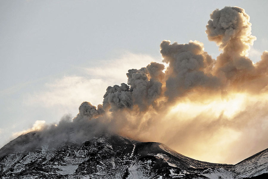
In recent weeks, in the media and on social networks, there has been much talk of volcanoes and eruptions, particularly those of Kīlauea (Hawaii) and the Fuego Volcano (Guatemala), which caused considerable material damage and the second case, a high number of victims. At these disastrous events, other eruptions have been added, spectacular but fortunately less damaging, such as the eruptions of the Fernandina and Sierra Negra volcanoes in the Galapagos Islands (Ecuador) and a new awakening, so far modest, of the Gunung Agung on the island. island of Bali (Indonesia) (Fig. 1).

Figure 1 – Eruption of Mount Agung on Bali Island (Indonesia) on the morning of June 28, 2018 Source: MAGMA Indonesia (https://magma.vsi.esdm.go.id/press/view.php?id=175 )
Given the intense media coverage of recent eruptions, one may have the impression that global volcanic activity is increasing. There are many people on « social networks » who ask if this is the case and if these events are related to each other. Another very frequent question concerns a hypothetical relationship between volcanic activity and seismic activity on a world scale, in particular because this one, in the current year, is – until now – weaker than the previous years. There is no shortage of « handyman » experts with their many followers, who say that yes, volcanic activity is increasing, and do not hesitate to accuse the « official scientists » of concealing or falsifying the truth.
In fact, all the information needed to understand the meaning of current volcanism on Earth is available on the net. To have a general idea of the evolution of the volcanic activity in time, it is necessary to consult various sources, almost exclusively in English, and especially to check their reliability (Figure 2).
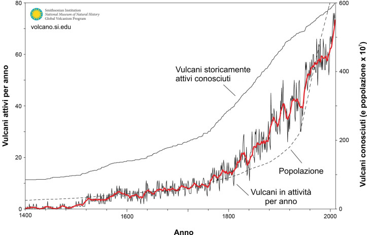
Figure 2 – The graph shows the number of volcanoes whose activity has been reported since the year 1400. The thin line indicates the number of volcanoes erupting per year, and the coarse red line represents the 10-year average of the same data. . . Eruptions with uncertain dates were not included. A volcano with more than one eruption in a year is shown only once. The « known volcanoes » are the total number of volcanoes which, in the respective year, were known to have made historical eruptions. « Population » is the estimate of the world’s human population. Source: Global Volcanism Network (http://volcano.si.edu/faq/index.cfm?question=historicalactivity)
By consulting reliable sites, it turns out that the current volcanic activity is quite normal. At any given time, about twenty volcanoes are active all over the world, some for many years, decades, or, like Stromboli, for centuries. Others wake up briefly and then return to a state of calm, and still others enter a new period of activity that may last longer or shorter. As they occur in remote and uninhabited areas of the planet, many of these eruptions are not in the sphere of media interest and therefore the general public does not know it. When, by chance, one or more eruptions have a strong and sudden impact on inhabited or tourist areas, the attention of the media becomes very strong. Subsequently, on the long wave of notoriety of high eruptions in the media, other eruptions, often harmless but well observed, are able for some time to appear in the « mainstream media » because there is a keen public interest. However, if previously there were no high-impact events, such as those in Kīlauea and the Fuego Volcano, minor events would escape the attention of the media and therefore the masses. In fact, during the first half of 2018, there were already more than 40 volcanoes in the world that recorded eruptive activity. Very few of them made headlines, in part because, fortunately, only a few eruptions caused significant damage.
Looking at the data contained in the American archives of the Global Volcanism Program of the Smithsonian Institution in Washington, it is clear that in recent centuries, the number of known active volcanoes has steadily increased and, at the same time, the number of observed eruptions. Figure 2 also shows the growth of the world population; it also clearly contributes to the knowledge of volcanoes and their eruptions. It must be remembered that in the Roman era, when the first volcano treatises were written, only nine active volcanoes were known, all in the Mediterranean region.
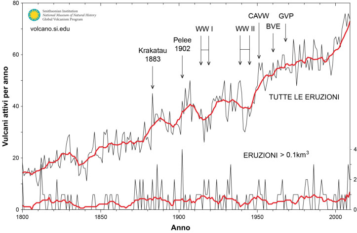
Figure 3 – Number of volcanoes whose activity has been reported since the year 1800. The thin line above shows the number of volcanoes erupting for years, while the large red upper line shows the 10-year average of same data. The lower lines show the annual number of large eruptions (with volumes of pyroclastic materials or lava exceeding 1 km3). It should be noted that the number of minor eruptions has increased considerably, while that of major eruptions has remained very regular throughout the period. The top indicates the dates of two extremely devastating eruptions and of great media impact (Krakatau in 1883, Pelee 1902), the two world wars (during which the reports of the eruptions fell much), the publication of the catalog of the active volcanoes of the World (CAVW), the Volcanic Eruptions Bulletin (BVE) and the beginning of the regular publication of volcanic activity news from the Global Volcanism Program (GVP). Source: Global Volcanism Network (http://volcano.si.edu/faq/index.cfm?question=historicalactivity).
Looking at the data for the last two centuries (Fig. 3), we find that the number of reported eruptions per year has increased after particular impact events, both in terms of damage and human casualties, as well as media, such as those of Krakatau in Indonesia (1883) and Mount Pelee in the Caribbean (1902), while during the two world wars, reports of eruptions declined sharply. The beginning of a systematic cataloging of active volcanoes (Catalog of active volcanoes in the world, CAVW, since 1955) and then the creation of regular publications on volcanic activity (Bulletin of Volcanic Eruptions, since 1960, and reports of the Global Volcanism Project Smithsonian Institution, since 1975) have led to a marked increase in the number of reported eruptions, which has, however, decreased in the 1980s and 1990s. Figure 3, however, shows a new increase at the beginning of the present century, which can be attributed to the advent of the Internet and « social media », which allow immediate and widespread dissemination of information, even by experts who have the opportunity to observe and document volcanic events, especially in remote areas, which otherwise would escape the attention of the scientific world.
The most significant data contained in Figure 3 is, however, only on major eruptions – so with perceptible effects on larger areas events have a high probability of being noticed even in more remote areas. Reports of such events show a very steady trend over the past two centuries, showing that volcanic activity does not increase at all, but rather that our knowledge and perception have changed. Coming back then to the current media attention caused by the eruptions of Kilauea and Fuego Volcano, we can say that this will be a drastically reduced attention as soon as the media will have no news to deal with, with the immediate consequence that the number of eruptions that will be noticed by the general public will come down again.
Source : Boris Behncke / ingvvulcani.wordpress.com. https://ingvvulcani.wordpress.com/2018/07/13/lattivita-vulcanica-della-terra-sta-aumentando-no-e-tutto-nella-normalita/


No comment yet, add your voice below!