January 08 , 2023.
Hawaii , Kilauea :
Saturday, January 7, 2023, 9:00 AM HST (Saturday, January 7, 2023, 19:00 UTC)
19°25’16 » N 155°17’13 » W,
Summit Elevation 4091 ft (1247 m)
Current Volcano Alert Level: WATCH
Current Aviation Color Code: ORANGE
Activity Summary:
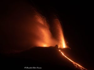
The summit eruption of Kīlauea Volcano, within Halemaʻumaʻu crater, continued over the past 24 hours. All recent eruptive activity has been confined to the crater. No significant changes have been observed at the summit or in either rift zone.
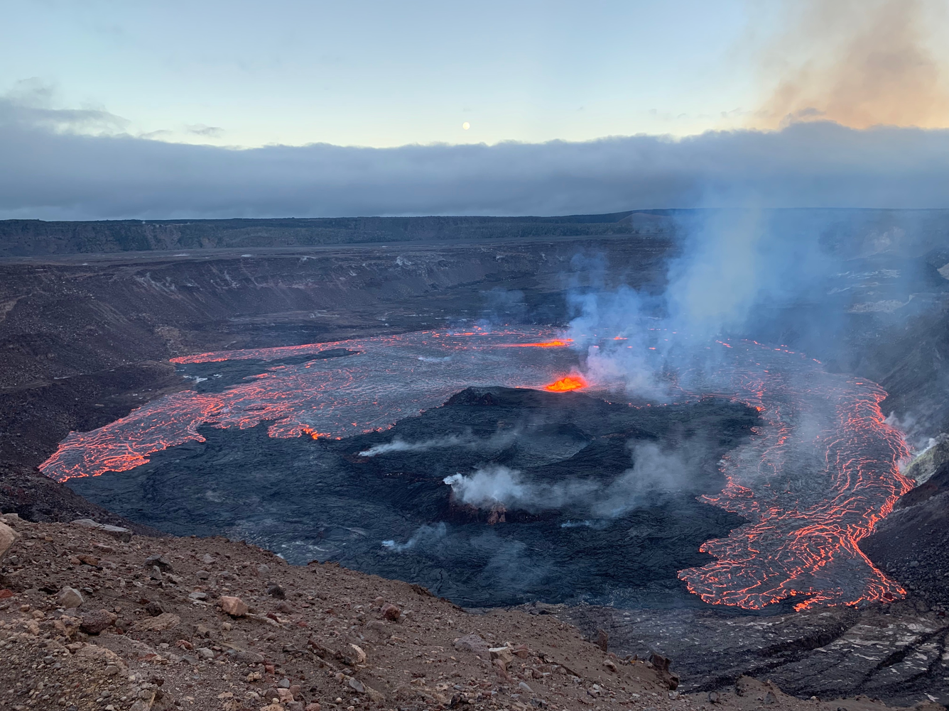
Halemaʻumaʻu Lava Lake Observations:
Eruption of lava from vents on the central eastern portion of Halemaʻumaʻu crater floor continued over the past 24 hours. Activity is concentrated in the eastern half of the crater and within the basin in the western half of the crater that was the focus of activity in 2021-2022.
Summit Observations:
Summit tiltmeters have recorded deflation over the past 24 hours. Volcanic tremor remains above background levels. A sulfur dioxide (SO2) emission rate of approximately 12,500 tonnes per day (t/d) was measured on January 6, 2023.
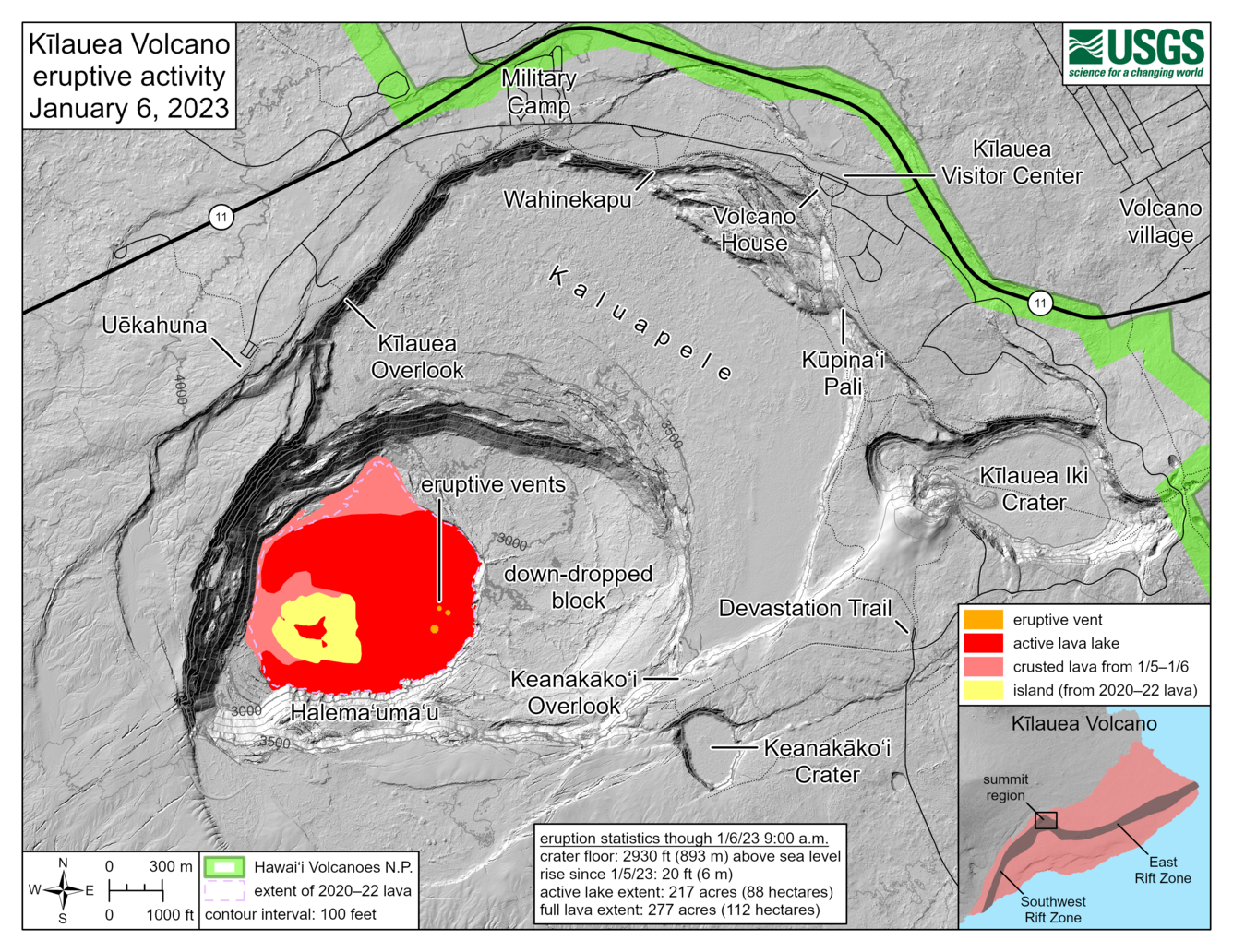
A new eruption at the summit of Kīlauea volcano began at approximately 4:34 p.m. on Thursday, January 5, 2023. This reference map depicts activity on the second day of the eruption, based on measurements taken from the crater rim at approximately 9:00 a.m. this morning. Multiple eruptive vents on the eastern floor of Halema‘uma‘u crater are effusing directly into a lava lake that sits atop them, with the vents taking the form of dome fountains. Lava from these dome fountains is flowing laterally across the rest of the crater floor. The extent of the active lava lake—the area in red—is 218 acres (88 hectares); part of this area is comprised of the active lava lake footprint from the end of the 2021–22 eruption, which has filled with new lava that upwelled from below. The full extent of new lava from this eruption, totaling both the active lava lake (red) and flows that have crusted over (pink) is 277 acres (112 hectares). Although this eruption has expanded the footprint of post-2018 lava within Halema‘uma‘u crater, scientists may note that this full extent value is smaller than that at the end of the 2021–22 eruption: 295 acres (119 hectares). This discrepancy exists because a higher-standing section of crater floor (yellow) around the former active lava lake has not yet been overflowed with new lava. The current laser rangefinder measurement places the new lava lake depth at 274 meters (899 feet), about 8 meters (26 feet) above the level of the cooled lava from the 2020-2022 summit eruption.
Rift Zone Observations:
No unusual activity has been noted along the East Rift Zone or Southwest Rift Zone; low rates of ground deformation and seismicity continue along both. Measurements from continuous gas monitoring stations downwind of Puʻuʻōʻō in the middle East Rift Zone remain below detection limits for SO2, indicating that SO2 emissions from Puʻuʻōʻō are negligible.
Source : HVO.
Photos : D. Downs , USGS.
Indonesia , Marapi / Kawah Ijen :
G Marapi :
VOLCANO OBSERVATORY NOTICE FOR AVIATION – VONA
Issued : January 08 , 2023
Volcano : Marapi (261140)
Current Aviation Colour Code : ORANGE
Previous Aviation Colour Code : orange
Source : Marapi Volcano Observatory
Notice Number : 2023MAR015
Volcano Location : S 0 deg 22 min 52 sec E 100 deg 28 min 23 sec
Area : West Sumatra, Indonesia
Summit Elevation : 9251 FT (2891 M)
Volcanic Activity Summary :
Eruption with volcanic ash cloud at 06h00 UTC (13h00 local).
Volcanic Cloud Height :
Best estimate of ash-cloud top is around 9891 FT (3091 M) above sea level or 640 FT (200 M) above summit. May be higher than what can be observed clearly. Source of height data: ground observer.
Other Volcanic Cloud Information :
Ash cloud moving to east. Volcanic ash is observed to be white to gray. The intensity of volcanic ash is observed to be thick.
Remarks :
Eruption recorded on seismogram with maximum amplitude 4.6 mm and maximum duration 59 second. Generated from Volcanic Eruption Notice (VEN)
———————————————————————————————————————————–
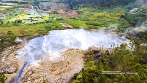
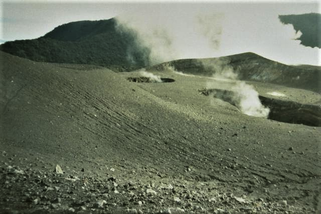
G Ijen :
Visual and instrumental observations
Visual
In the period from December 1, 2022 to January 7, 2023, the weather was clear to rainy, the wind weak to strong towards the East, the South and the West. The smoke from Solfatara is weakly pressurized white with low intensity, high smoke between 50 and 400 meters above the summit. The water temperature of the crater in December 2022 measured at 16°C. On January 5, 2023, an inspection of the crater showed that the water temperature of the crater lake had risen to 45.6 ° C. The water color of the crater lake is light green. Thick white smoke from low to moderate pressure solfatara. The smell of sulfur gas was strong.
Instrumental observations
Upward trend of surface or shallow earthquakes. During the period from December 1, 2022 to January 7, 2023, 246 emission earthquakes were recorded, 1 non-harmonic tremor earthquake, 3 « tornillo » type earthquakes, 890 shallow volcanic earthquakes, 20 deep volcanic earthquakes, 9 local tectonic earthquakes and continuous tremors with an amplitude of 0.5 to 2 mm (dominant value of 1 mm).
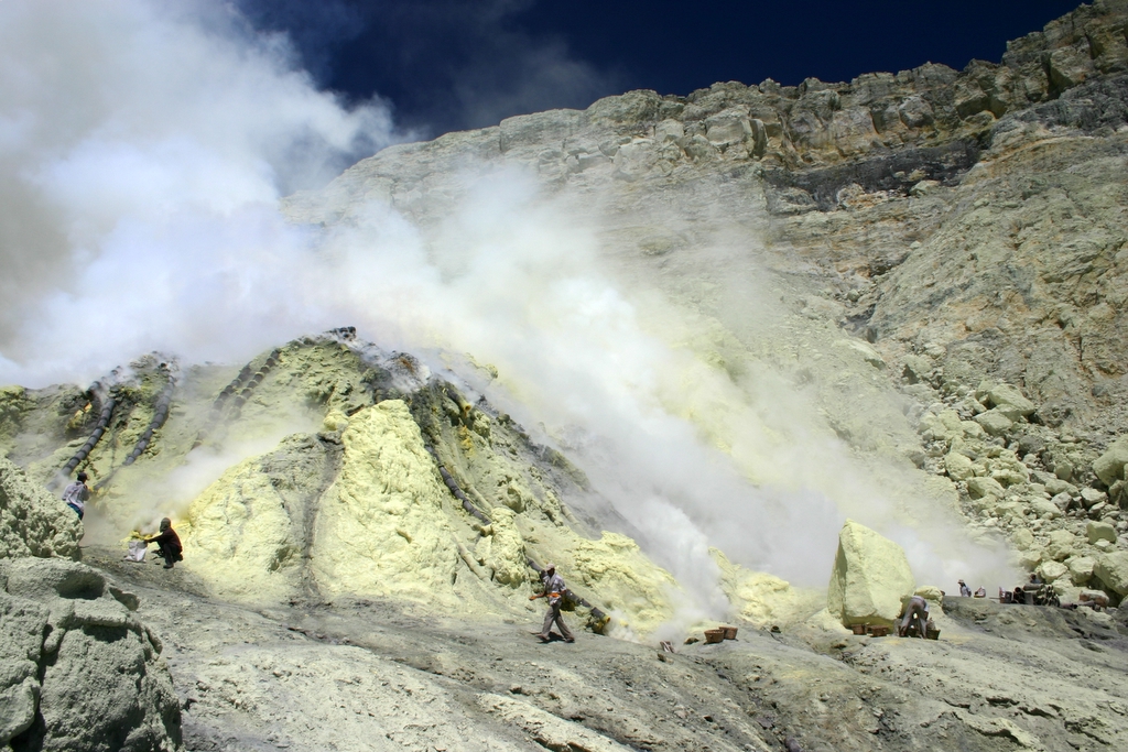
Several events of increased activity from the Ijen crater are often followed by « gas explosion » events or eruptions / gas jets from the Ijen crater lake, the gas erupting is mainly CO2 . This CO2 gas has a density that is heavier than air, so the CO2 that comes out due to this eruption / emission, tends to flow down the valley like during the gas emission from the Ijen crater in March 2018.
Conclusions and recommendations
Based on the results of a comprehensive assessment, the activity level of G. Ijen has been raised from Level I (normal) to Level II (WASPADA) from January 7, 2023 at 2:00 p.m. WIB with recommendations adjusted to the latest potential hazards.
G. Ijen’s activity level may be reassessed if there is a significant visual and instrumental change in activity.
Regarding the activity of G. Ijen at the level of activity level II (alert), it is recommended:
• People around G. Ijen and visitors/tourists/miners should not approach the crater within 1.5 km of the crater rim.
Source : Magma Indonésie.
Photos : Gede Suantika, 1993 (Observatoire volcanologique d’Indonésie). Blethrow , wikipedia
Chile , Villarica :
According to the instrumental analysis reported by the National Volcanic Monitoring Network (RNVV) of the National Geology and Mining Service, Sernageomin, and based on the updated volcanic activity report of Sernageomin, an increase in the activity of surface around the crater of the Villarrica volcano has been identified in recent weeks, which has resulted in the expulsion of material that has fallen to almost 500 meters from the crater, which is very close to the security perimeter originally defined for this purpose.
This determination was established during a technical table held this morning, which was attended by representatives of Senapred, Sernageomin and the municipality of Pucón.
By virtue of this information, it was considered as a precaution to increase the security perimeter according to the current scenario, by defining an area of 1,000 meters around the crater. This measure indicates that citizen access to this area is restricted.
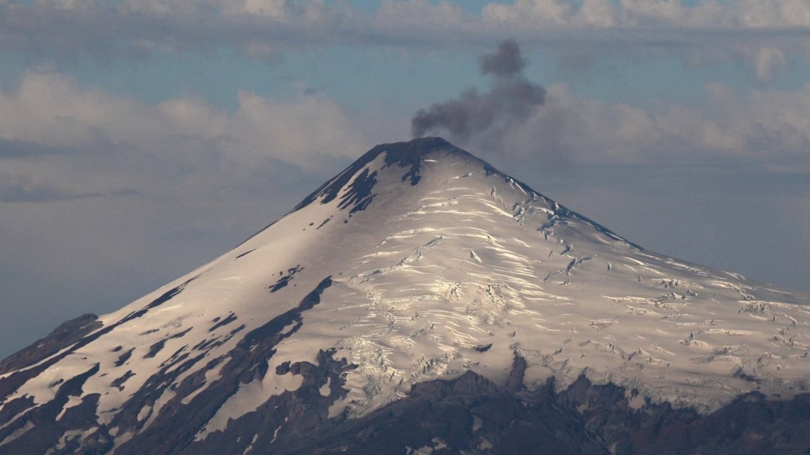
During the last fortnight, the internal activity of the Villarrica volcano has been maintained without major variations in its energy and its number of seismic events. However, a slight increase in surface activity was observed, explosions occurred at the crater level, where we were able to measure the range through our glowing particle monitoring cameras, especially at night, where we have measured ranges of up to 480 meters from the center of the crater.
Currently, our danger zone is 500 meters from the center of the crater, so since this increase is observed, we are making a change to one kilometer to ensure that these projections of incandescent particles and pyroclastic bombs are within the defined danger zone .
Source : Sernageomin.
Photo : 24 Horas.
Colombia , Nevado del Ruiz :
Subject: Nevado del Ruiz volcano activity level bulletin.
The activity level continues at the yellow activity level or (III): changes in the behavior of volcanic activity.
Regarding the monitoring of the activity of the Nevado del Ruiz volcano, the COLOMBIAN GEOLOGICAL SERVICE reports that:
Seismic activity related to fluid dynamics within volcanic conduits increased both in number of events recorded and in seismic energy released compared to the previous week. The decrease in energy of the continuous volcanic tremor signal stands out, which continues to be recorded with low energy levels. Thanks to the images captured by the cameras installed in the volcano area and by the report of the staff of the National Natural Park of Los Nevados, several pulsatile emissions of gas and ash associated with some of the seismic signals have been confirmed.
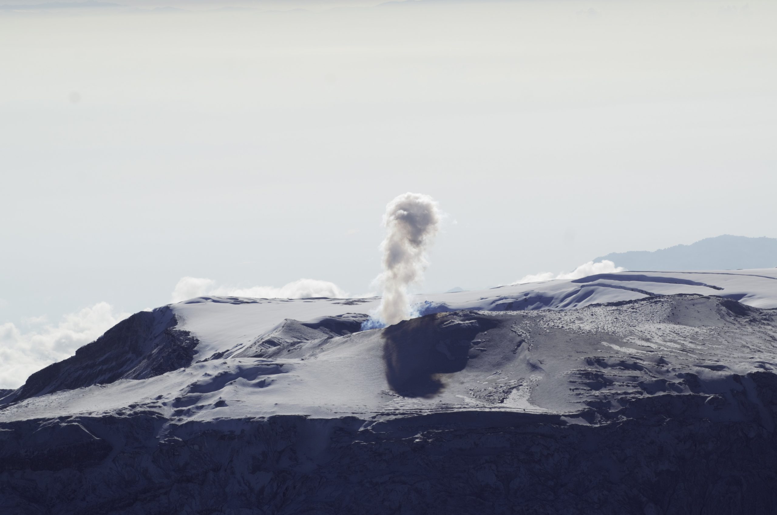
Seismic activity associated with rock fracturing decreased both in the number of earthquakes recorded and in the seismic energy released compared to the previous week. The earthquakes were located mainly in the Arenas crater and scattered around it. The depth of the earthquakes ranged from about 0.4 to 6.0 km. The maximum magnitude observed during the week was 1.5 ML (Local Magnitude) and corresponds to the earthquake recorded on January 2 at 3:59 p.m. (local time) and was located in the Arenas crater, at a depth of 2.0 km.
Deformation of the volcanic surface continues to show minor changes.
Source et photo : SGC