January 15 , 2022 .
Tonga Islands , Hunga-Tonga-Hunga-Ha’apai :
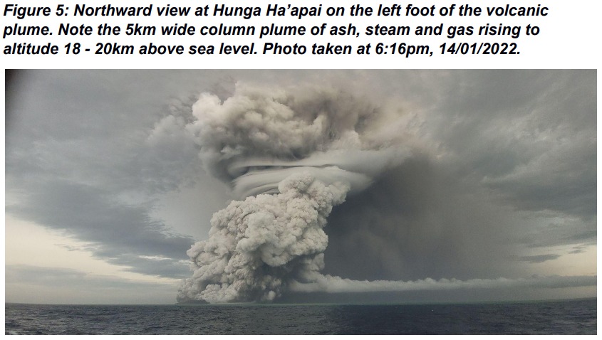
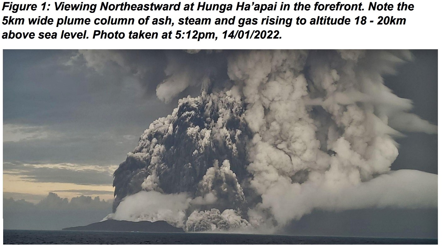
Public Notice from the Tonga Geological Services monitoring the Hunga-Tonga-Hunga-Ha’apai (HTHH) Eruption issued at 12:30 AM, January 15 , 2022.
Observations of satellite images captured between 5:10 PM and 11:30 PM 14/01/2022 and field visit are as follows.
The eruption is continuous, maintaining a 5km wide column plume of ash, steam and gas rising to altitude 18-20km above sea level. The plume expands radially up to a radius of 240km from the volcano, passing over Tongatapu, ‘Eua, Ha’apai and Vava’u group. At 10:30 PM the plume had declined to altitude 18km above sea level.
Ashfall was reported in Mango and Fonoi Islands of Ha’apai to impact the rainwater tanks. Sometimes volcanic ash in the atmosphere is not visible but stinging on the eyes or irritation are signs. If dark coloured particles are observed on outdoor surfaces at a large scale, it may also be a sign of ashfall. It is advised to stay indoors and to protect your rainwater harvestings. Please ensure to cover your water reservoirs. If one feels short of breath please wear a mask to reduce inhalation of ash from the air.
Strange oceans and nearshore turbulence were seen in the shores of Ha’apai and Tongatapu islands. These are caused by the volcanic eruption and these dynamic currents can cause chaos if one tries to sail or swim in it. It is advised that the public stay out of the water until the volcanic eruption until further notice.
Public Notice from the Tonga Geological Services monitoring the Hunga-Tonga-Hunga-Ha’apai (HTHH) Eruption issued at 1:45PM, January 15 , 2022..
Observations of satellite images captured between 5:00AM January 15 , 2022. and 12:40PM January 15 , 2022 are as follows.
The volcanic eruption continues, with ash emitted and detected at 7:20AM this morning . This ash plume was due to an eruption that lasted 10 – 15 minutes and was drifting downwind to the east from Hunga . No further eruption has been detected since then.
Owners of rainwater harvesting systems in all Tonga are advised to check for ashfall on your roofs for ash before reconnecting your guttering systems. Please clean if ashfall is evident.
For locations of residents where the pungent smell of sulphur or ammonia is experienced please use breathing masks if helpful.
Source and photo : Tonga Geological Services, Government of Tonga
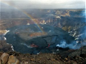
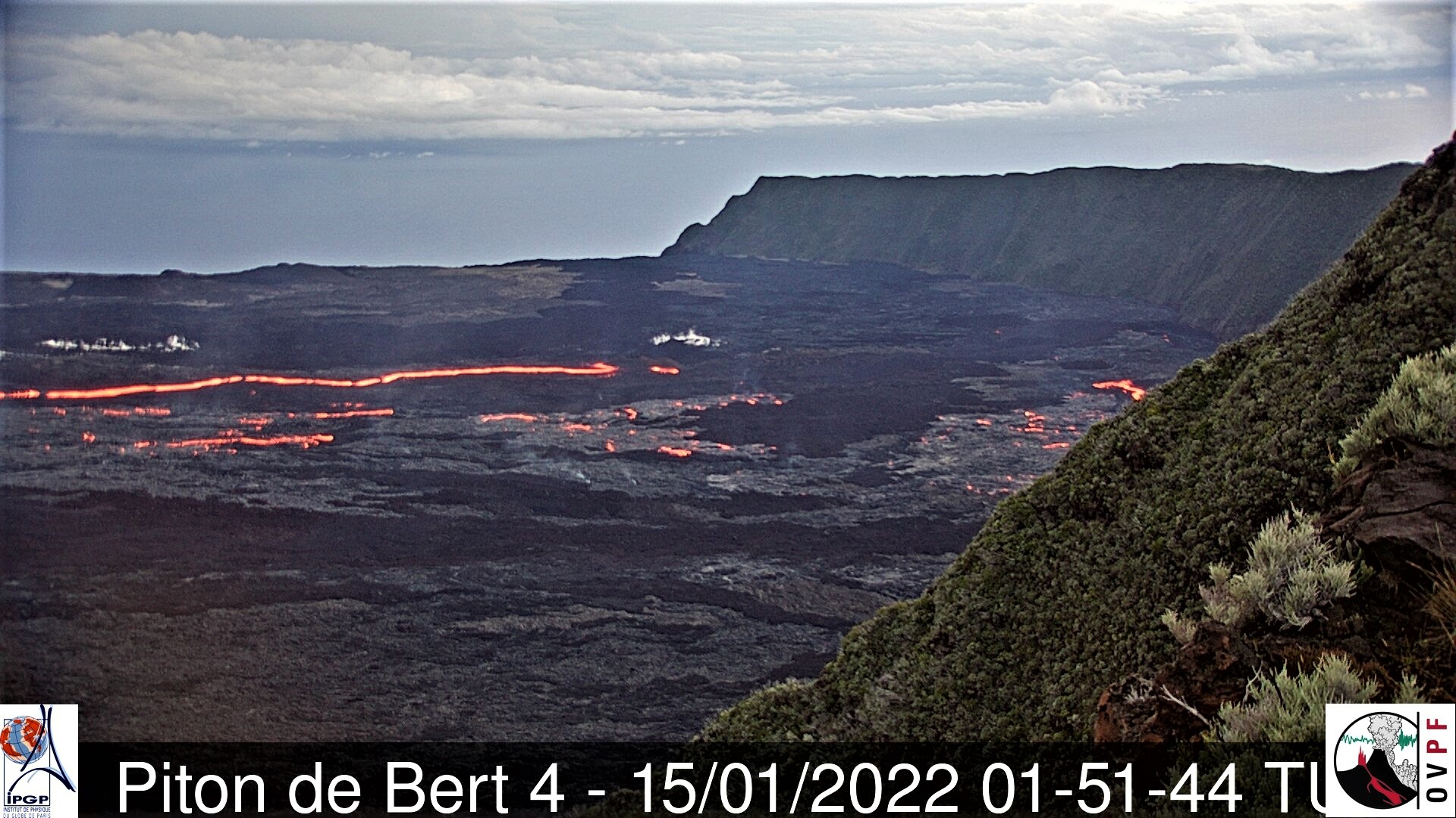
La Réunion , Piton de la Fournaise :
Press release of January 15, 2022 – 11:00 a.m.
The eruption started on December 22, 2021 around 3:30 a.m. local time continues. Over the last 24 hours, the amplitude of the tremor has been decreasing for about thirty hours (Figures 1).
Fluctuations in the amplitude of the tremor are partly related to the level of the lava lake which varies according to the mode of degassing, the erosion of the eruptive conduit and the sporadic openings of the tunnels which allow emptying of the cone. The openings in the tunnels generate a drop in pressure at the level of the cone and within the tunnels, and lead to a drop in the amplitude of the tremor.
This decrease in the amplitude of the tremor was accompanied by the appearance of numerous resurgences and a persistent flow within the lava field.

The weather conditions were favorable in the early morning for the observation of the eruptive site. However, these have been deteriorating since mid-morning. The observations made show that the lava projections at the level of the cone above the cone have almost disappeared. In addition, no overflow from the lava lake has been reported in the past 24 hours.
The front of the last flow arm set up along the southern rampart of the Enclos Fouqué for several days is progressing only very slowly given the relatively low slopes in the sector.
Over the last 24 hours:
– The surface deformations always show a deflation at the level of the summit zone, linked to the emptying of the magma reservoir located under the summit (about 2-2.5 km deep) feeding the eruptive site.
– 55 volcano-tectonic earthquakes, of low magnitude (<1), were recorded under the summit. This seismicity is linked to the emptying of the magma reservoir located under the summit, weakening its roof.
– Due to the temporary improvements in meteorological conditions at the eruptive site, a series of lava flow estimates could be made over the last 24 hours by satellite method with the
HOTVOLC platform (OPGC – Clermont Auvergne University). The flows could be estimated between 3 and 68 m3 /s. The dispersion of these measurements as well as the very high measured value (68 m3/s) do not reflect the real flow of lava and must be attributed to the method used (die from the IR radiation of the flow which increases when the liquid lava reappears on the surface of the lava field) as well as the events observed yesterday: emptying of the lava lake and a large number of associated resurgences throughout the lava field.
Alert level: Alert 2-1 (eruption in the Enclos )
Source : OVPF
Alaska , Pavlof :
55°25’2″ N 161°53’37 » W,
Summit Elevation 8261 ft (2518 m)
Current Volcano Alert Level: WATCH
Current Aviation Color Code: ORANGE
The eruption of Pavlof Volcano continues. Strongly elevated surface temperatures corresponding to the active lava flow on the southeast flank of Pavlof were observed in satellite data throughout the week. Web camera views were mostly obscured throughout the week, but occasional clear views showed robust steam emissions. Satellite-based radar views showed a widening of the vent and possible lava flows towards the east. Elevated seismicity, consisting of periods of sustained tremor, was detected throughout the past week. No explosions or ash emissions were detected.
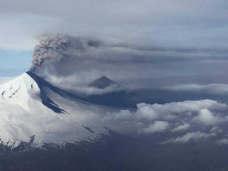
Periods of lava fountaining from the vent on the volcano’s upper southeast flank have been occurring since mid-November 2021. This activity has built a small cone and sent flows down the flank that melt the snow and ice and produce variable amounts of meltwater. The meltwater typically incorporates loose debris on the flank of the volcano and forms thin (<2 m thick) lahars. The lahar deposits extend down the east-southeast flank for several kilometers, not quite to the base of the volcano.
Previous eruptions of Pavlof indicate that the level of unrest can change quickly and the progression to more significant eruptive activity can occur with little or no warning.
Pavlof is monitored by local seismic and infrasound sensors, satellite data, web cameras, and remote infrasound and lightning networks.
Source : AVO
Photo : Torres, Austin
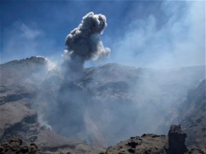
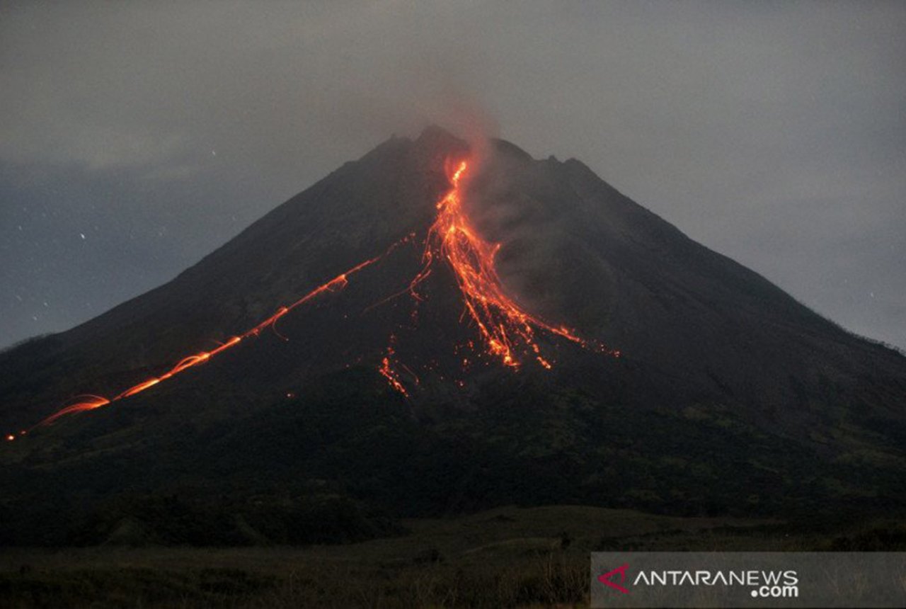
Indonesia , Merapi :
Report on the activity of Mount Merapi from January 6 to 13, 2022
OBSERVATION RESULT
Visual
The weather around Mount Merapi is generally sunny in the morning and evening, while it is foggy in the afternoon. White, fine to thick, low pressure, 100m high smoke was observed from the Mount Merapi observation post in Ngepos on January 10, 2022 at 08:40 WIB.
This week, 4 hot avalanche clouds were observed in the southwest, upstream of the Bebeng River with a maximum slip distance of 2,500 m. Lava avalanches were observed 123 times, mainly in the southwest, up to the Bebeng River with a maximum slip distance of 2,200 m.
No significant morphological changes were observed either in the Southwest lava dome or in the central dome. The volume of the Southwest lava dome is 1,670,000 m3 and the central dome is 3,007,000 m3.
Seismicity
This week, the seismicity of Mount Merapi recorded:
4 hot cloud avalanche earthquakes (AP),
1 shallow volcanic earthquake (VTB),
1 low frequency earthquake (LF),
35 multi-phase earthquakes (MP),
827 avalanche earthquakes (RF),
53 emission earthquakes (DG),
10 tectonic earthquakes (TT).
The intensity of this week’s earthquake is still quite high.
Deformation
Mount Merapi’s deformation, which was monitored using EDM this week, showed a distance shortening rate of 0.2 cm/day.
Rain and lahars
This week, it rained at the Mount Merapi observation post with an intensity of 53 mm/hour for 80 minutes at the Ngepos post on January 11, 2022. There were no reports of lahars or additional flow in the rivers that have their source on Mount Merapi.
CONCLUSION
Based on the results of visual and instrumental observations, it is concluded that:
The volcanic activity of Mount Merapi is still quite high in the form of effusive eruption activity. The state of the activity is defined at the « SIAGA » level.
Source : BPPTKG
Photo : ANTARA/Andreas Fitri Atmoko/wsj
Ecuador , Sangay / Wolf :
Volcanic monitoring work and maintenance of the Sangay volcano multi-parameter station.
According to the coordination of the National Risk and Emergency Management Service (SNGRE) and the logistical support of the Aeronautical Group of the Army N°45 PICHINCHA, technicians from the Geophysical Institute of the National Polytechnic School (IG -EPN), carried out overflights of the Sangay volcano on Monday, December 27, 2021 from the city of Macas, province of Morona Santiago in order to carry out visual overflights, thermal and gas measurements, as well as technical maintenance of the station. multiparameter monitoring (SAGA)-EPN), at the Edmundo Carvajal airport in the city of Macas. This made it possible to carry out volcanic monitoring work, using visual and infrared cameras, and MultiGas. In particular, the work focused on the observation of surface activity in the summit area, the south-east and north flanks. As a result, the presence of 3 active vents and two lava flows descending along these two flanks has been confirmed (Fig. 2 and 3). The referenced vents correspond to: 1. Central vent with Strombolian activity and lava flow towards the southeast ravine 2. North vent with gas emissions and lava flow towards the northern ravine.
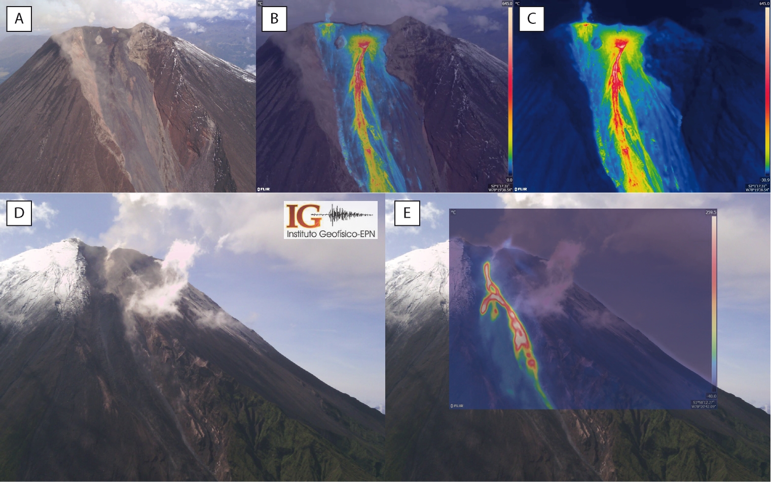
Thanks to the preliminary analysis of the thermal images, it was possible to measure maximum apparent temperatures (TMA) of up to 645°C, determined at the level of the central vent (Fig. 3, B and C). The West and North vents showed values of 410 and 515°C respectively (Fig. 3, B and E). Moreover, it was observed that the active lava flows emplaced in the South-East and North ravines reach lengths of 540 and 370 m, respectively (Fig. 3, B, C and E) and have TMAs of 580 and 450°C.
Information VOLCÁN WOLF Nº 2022-002Quito, Friday January 14, 2022.
On the Wolf volcano in the Galapagos Islands, the MOUNTS satellite monitoring system shows an increase in SO2 emissions compared to the last 3 days. In addition, thanks to the MIROVA and VIIRS satellite monitoring platforms, an increase in the rate of thermal alerts recorded for this volcano is observed.

However, in recent days, the seismic activity associated with this volcano has not shown any significant changes. It is recommended to seek information from official sources. The Geophysical Institute monitors and any new developments will be reported.