January 04, 2022. EN. La Reunion Island : Piton de la Fournaise , Peru : Sabancaya , Indonesia : Ili Lewotolok , Chile : Nevados de Chillan , Ecuador : Tungurahua .

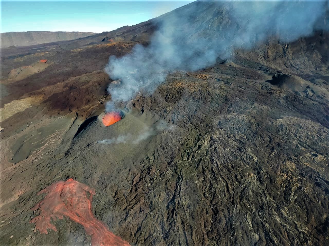
January 04 , 2022.


La Réunion Island , Piton de la Fournaise :

Press release of January 03, 2022 – 4:00 p.m.

The eruption that began on December 22, 2021 at around 3:30 a.m. local time continues. Over the last 24 hours the amplitude of the eruptive tremor (indicator of an emission of lava on the surface) still shows fluctuations. The fluctuations observed can be linked either to:
– the cone and the field of lava tunnels downstream of the cone, which undergo phases of construction and dismantling, thus influencing the speed of lava flows at the level of the vent;
– or to punctual releases of pockets of gas trapped in the supply ducts which can be released suddenly leading to an increase in the tremor.
The average amplitude of the tremor is (over the last few hours) about 50% of its initial amplitude.

The latest observations still show lava fountain activity within the cone that has built up since the start of the eruption. The videos from the webcams of the OVPF-IPGP-IRT last night, as well as the observations made today from the Piton de Bert, show activity with lava fountains which occasionally exceed the height of the cone. Numerous resurgences of lava flows are still visible at the roof of the lava tunnel that has developed downstream from the cone. These resurgences are sporadic and can last from a few minutes to
a few hours .

Over the last 24 hours:
– No volcano-tectonic earthquakes have been recorded.
– Surface deformations no longer show significant signals.
– The CO2 concentrations in the soil in the Gîte du volcan sector have been increasing for several days. This parameter will be monitored over the next few days because it may be linked to the arrival of new magma, coming from deeper areas, at the level of the shallow reservoir.

– Lava flows could be estimated by satellite method with the HOTVOLC platform (OPGC – Clermont Auvergne University). They were between 2 and 10 m3 / sec. These variations are explained by the method, which relies on the infrared radiation of the flow, the perception of which by satellites can be largely influenced by the weather conditions above the flows as well as the surface conditions of the flows.


No assessment of the position of the flow front could be made. But given the relief with gently sloping slopes in the area, the lava field continues to extend mainly laterally and by thickening at the level of the network of lava tunnels set up on the plateau downstream of the eruptive cone.

Alert level: Alert 2-1 (eruption in the Enclos ).

Source : OVPF/ IPGP.

Photo : Frederick Leveneur via Facebook , PGHM via OVPF.


Peru , Sabancaya :

Analysis period: from December 27, 2021 to January 02, 2021, Arequipa, January 03, 2021.
Alert level: ORANGE

The Geophysical Institute of Peru (IGP) reports that the eruptive activity of the Sabancaya volcano remains at moderate levels, that is to say with the recording of an average of 32 daily explosions, with columns of ash and gas up to 2.8 km altitude above the summit of the volcano and their consequent dispersion. Therefore, for the following days, no significant change is expected in eruptive activity.

The IGP recorded and analyzed the occurrence of 746 earthquakes of volcanic origin, associated with the circulation of magmatic fluids within the Sabancaya volcano. An average of 32 explosions was recorded daily. During this period, Volcano-Tectonic (VT) earthquakes associated with rock fractures were located mainly in the North-West of Sabancaya and presented magnitudes of M 2.9.


The monitoring of the deformation of the volcanic structure using GNSS techniques (processed with fast orbits) does not present any significant anomalies. However, in general, an inflation process was observed in the northern sector (around the Hualca Hualca volcano). Visual surveillance identified columns of gas and ash up to 2.8 km altitude above the summit of the volcano, which were scattered towards the western, southwest and northwest sectors of the Sabancaya. Satellite recordings identified the presence of 8 thermal anomalies (maximum value of 28 MW) associated with the presence of a lava body on the surface of the volcano’s crater.

RECOMMENDATIONS
• Keep the volcanic alert level in orange.
• Do not approach within a radius of less than 12 km from the crater.

Source : IGP

Photo : Ingemmet ( archive 2017).


Indonesia , Ili Lewotolok :

VOLCANO OBSERVATORY NOTICE FOR AVIATION – VONA

Issued : January 04 , 2022 .
Volcano : Ili Lewotolok (264230)
Current Aviation Colour Code : ORANGE
Previous Aviation Colour Code : unassigned
Source : Ili Lewotolok Volcano Observatory
Notice Number : 2022LEW01
Volcano Location : S 08 deg 16 min 19 sec E 123 deg 30 min 18 sec
Area : East Nusa Tenggara, Indonesia
Summit Elevation : 4554 FT (1423 M)

Volcanic Activity Summary :
Eruption with volcanic ash cloud at 02h29 UTC (10h25 local). Eruption and ash emission is not continuing.

Volcanic Cloud Height :
Best estimate of ash-cloud top is around 6474 FT (2023 M) above sea level, may be higher than what can be observed clearly. Source of height data: ground observer.

Other Volcanic Cloud Information :
Ash-cloud moving to East southeast

Remarks :
Seismic activity is dominated by gas emission earthquake.

The volcano was clearly visible until it was covered in fog. The smoke from the crater is white / gray with low to moderate intensity, about 100-600 meters above sea level from the summit. The weather is sunny, cloudy to rainy. The wind is weak in the east.

The eruption was accompanied by a weak to moderate rumbling and an emission of incandescent material up to 200 m from the summit towards the south-east.


Seismicity is related to magmatic activity and tectonic activity. It was recorded:
– 22 eruption earthquakes / explosions
– 97 earthquakes of emissions
– 36 non-harmonic tremors
– 3 Harmonic tremors
– 1 Tornillo-type earthquake
– 3 deep volcanic earthquakes
– 2 local tectonic earthquakes
– 8 distant tectonic earthquakes
– Continuous tremor, amplitude 0.5-9.8 mm (mainly 0.5 mm)

Sources : Magma Indonésie , PVMBG.

Photos : Magma Indonésie , Kodi Setiawan(archives).


Chile , Nevados de Chillan :

Special Report on Volcanic Activity (REAV), Ñuble region, Nevados de Chillán volcanic complex, January 04, 2021, 1:05 a.m. local time (Continental Chile).

The National Service of Geology and Mines of Chile (Sernageomin) publishes the following PRELIMINARY information, obtained thanks to the monitoring equipment of the National Volcanic Monitoring Network (RNVV), processed and analyzed at the Volcanological Observatory of the Southern Andes ( Ovdas):

On Tuesday 04 January 2021, at 00:37 local time (03:37 UTC), the monitoring stations installed near the volcanic complex of Nevados de Chillán recorded an earthquake associated with the fracturing of rocks (volcano-tectonic type) in the volcanic system.

The characteristics of earthquakes after their analysis are as follows:

ORIGINAL TIME: 00:37 local time (03:37 UTC)
LATITUDE: 36.839 ° S
LONGITUDE: 71.331 ° W
DEPTH: 3.3 km
LOCAL MAGNITUDE: 3.0 Ml

OBSERVATIONS:

No surface activity associated with this event was observed, and the weather conditions in the area made it impossible to observe the summit of the volcano.

The volcanic technical alert remains at the Yellow level.

Sources et photo :  Sernageomin.


Ecuador , Tungurahua :

The Geophysical Institute of the National Polytechnic School informs that through the Volcanic Observers Network (ROVE) and the IGEPN cameras, it was recorded this Monday January 3, 2022, a process of resuspension of ash on the northwest flank of the Tungurahua volcano. This process was recorded from around 12:00 TL and is due to the strong winds in the area and the dry climate. There is no change in the internal activity of the Tungurahua volcano. The Geophysical Institute of the National Polytechnic School is monitoring the activity of the volcano and will report on any changes that may be recorded.

Tungurahua, a steep-sided andesitic-dacitic stratovolcano that towers more than 3 km above its northern base, is one of Ecuador’s most active volcanoes. Three major edifices have been sequentially constructed since the mid-Pleistocene over a basement of metamorphic rocks. Tungurahua II was built within the past 14,000 years following the collapse of the initial edifice. Tungurahua II collapsed about 3,000 years ago and produced a large debris-avalanche deposit to the west. The modern glacier-capped stratovolcano (Tungurahua III) was constructed within the landslide scarp. Historical eruptions have all originated from the summit crater, accompanied by strong explosions and sometimes by pyroclastic flows and lava flows that reached populated areas at the volcano’s base. Prior to a long-term eruption beginning in 1999 that caused the temporary evacuation of the city of Baños at the foot of the volcano, the last major eruption had occurred from 1916 to 1918, although minor activity continued until 1925.

Sources : IGEPN , GVP.

04 Janvier 2022. FR. Ile de La Réunion : Piton de la Fournaise , Pérou : Sabancaya , Indonésie : Ili Lewotolok , Chili : Nevados de Chillan , Equateur : Tungurahua .

04 Janvier 2022.


Ile de La Réunion , Piton de la Fournaise :

Communiqué du 03 Janvier 2022 – 16h00 .

L’éruption débutée le 22 Décembre 2021 aux alentours de 3h30 heure locale se poursuit. Sur les dernières 24h l’amplitude du trémor éruptif (indicateur d’une émission de lave en surface) montre toujours des fluctuations  . Les fluctuations observées peuvent être liées soit :
– au cône et au champ de tunnels de lave en aval du cône, qui subissent des phases de construction et de démantèlement, influant ainsi la vitesse des débits de lave au niveau de l’évent ;
– soit à des libérations ponctuelles de poches de gaz piégées dans les conduits d’alimentation qui peuvent être libérées soudainement entrainant une augmentation du trémor.
L’amplitude moyenne du trémor se situe (au cours des dernières heures) à environ 50% de son amplitude initiale .

Les dernières observations montrent toujours une activité de fontaines de lave au sein du cône qui s’est édifié depuis le début de l’éruption. Les vidéos des webcams de l’OVPF-IPGP-IRT de cette nuit ainsi que les observations réalisées ce jour depuis le Piton de Bert, montrent une activité avec des fontaines de lave qui dépassent occasionnellement la hauteur du cône. De nombreuses résurgences de coulées de lave sont toujours visibles au toit du tunnel de lave qui s’est mis en place en aval du cône . Ces résurgences sont sporadiques et peuvent durer de quelques minutes à
quelques heures .

Sur les dernières 24h :
– Aucun séisme volcano-tectoniques n’a été enregistré.
– Les déformations de surface ne montrent plus de signaux significatifs.
– Les concentrations en CO2 dans le sol dans le secteur du Gîte du volcan sont en augmentation depuis quelques jours. Ce paramètre sera à suive ces prochains jours car il peut être lié à l’arrivée d’un nouveau magma, provenant de zones plus profondes, au niveau du réservoir superficiel.

– Des débits de lave ont pu être estimés par méthode satellite avec la plateforme HOTVOLC (OPGC – université Clermont Auvergne). Ils étaient compris entre 2 et 10 m3 /sec. Ces variations s’expliquent par la méthode, qui se base sur le rayonnement infrarouge de la coulée, dont la perception par les satellites peut être largement influencée par les conditions météorologiques au-dessus des coulées ainsi que les conditions de surface des coulées.


Aucune évaluation de la position du front de la coulée n’a pu être faite. Mais compte tenu du relief avec des pentes faiblement inclinées dans le secteur, le champ de lave continue de s’étendre principalement latéralement et par épaississement au niveau du réseau de tunnels de lave mis en place sur le plateau en aval du cône éruptif.

Niveau d’alerte : Alerte 2-1 (éruption dans l’Enclos).

Source : OVPF/ IPGP.

Photo : Frederick Leveneur via Facebook , PGHM via OVPF.


Pérou , Sabancaya :

Période d’analyse: du 27 Décembre 2021 au  02 Janvier 2021 , Arequipa, 03 Janvier 2021.
Niveau d’alerte: ORANGE

L’Institut géophysique du Pérou (IGP) rapporte que l’activité éruptive du volcan Sabancaya reste à des niveaux modérés, c’est-à-dire avec l’enregistrement d’une moyenne de 32 explosions quotidiennes , avec des colonnes de cendres et de gaz jusqu’à 2,8 km d’altitude au dessus du sommet du volcan et leur dispersion consécutives . Par conséquent, pour les jours suivants, aucun changement significatif n’est attendu concernant l’ activité éruptive.

L’IGP a enregistré et analysé l’occurrence de 746 tremblements de terre d’origine volcanique, associés à la circulation de fluides magmatiques à l’intérieur du volcan Sabancaya. Une moyenne de 32 explosions a été enregistrée quotidiennement . Au cours de cette période, les tremblements de terre de type Volcano-Tectoniques (VT) associés à des fracturations rocheuses ont été localisés principalement dans le Nord-Ouest du Sabancaya et ont présenté des magnitudes de M 2,9 . 


Le suivi de la déformation de la structure volcanique à l’aide de techniques GNSS (traitées avec des orbites rapides) ne présente pas d’anomalies significatives. Cependant, de manière générale, un processus d’inflation a été observé dans le secteur  Nord ( environs du volcan Hualca Hualca ). La surveillance visuelle a permis d’identifier des colonnes de gaz et de cendres jusqu’à 2,8  km d’altitude au dessus du sommet du volcan , qui étaient dispersées vers les secteurs Ouest , Sud-Ouest et Nord- Ouest du  Sabancaya.  Les enregistrements par satellites ont identifiés la présence de 8 anomalies thermiques ( valeur maximale de 28 MW ) associées à la présence d’un corps de lave à la superficie du cratère du volcan  . 

RECOMMANDATIONS
• Garder le niveau d’alerte volcanique en orange.
• Ne pas s’ approcher dans un rayon de moins de 12 km du cratère.

Source : IGP

Photo : Ingemmet ( archive 2017).


Indonésie , Ili Lewotolok :

AVIS D’OBSERVATION DU VOLCAN POUR L’AVIATION – VONA

Émis : 04 janvier 2022 .
Volcan : Ili Lewotolok (264230)
Code Couleur Aviation Actuel : ORANGE
Code couleur aviation précédent : non attribué
Source : Observatoire du volcan Ili Lewotolok
Numéro d’avis : 2022LEW01
Emplacement du volcan : S 08 deg 16 min 19 sec E 123 deg 30 min 18 sec
Zone : East Nusa Tenggara, Indonésie
Altitude du sommet : 4554 FT (1423 M).

Résumé de l’activité volcanique :
Eruption avec nuage de cendres volcaniques à 02h29 UTC (10h25 local). L’éruption et l’émission de cendres ne se poursuivent pas.

Hauteur des nuages volcaniques :
La meilleure estimation du sommet du nuage de cendres est d’environ 6474 FT (2023 M) au-dessus du niveau de la mer, ce qui peut être plus élevé que ce qui peut être clairement observé. Source des données de hauteur : observateur au sol.

Autres informations sur les nuages volcaniques :
Nuage de cendres se déplaçant vers l’Est Sud-Est

Remarques :
L’activité sismique est dominée par les séismes d’émissions de gaz.

Le volcan était clairement visible jusqu’à ce qu’il soit recouvert de brouillard. La fumée issue du cratère  est blanche / grise avec une intensité faible à modérée, à environ 100-600 mètres d’altitude depuis le sommet. Le temps est ensoleillé, nuageux à pluvieux. Le vent est faible à l’Est.

L’éruption s’est accompagnée d’un grondement faible à modéré et d’une émission de matière incandescente jusqu’à 200 m du sommet vers le Sud-Est.


La sismicité est liée à l’activité magmatique et à l’activité tectonique. Il a été enregistré :
– 22 tremblements de terre d’éruption/explosions
– 97 tremblements de terre d’émissions
– 36 tremors non harmoniques
– 3 tremors Harmoniques
– 1 tremblement de terre de type Tornillo
– 3 tremblements de terre volcaniques profonds
– 2 tremblements de terre tectoniques locaux
– 8 tremblement de terre tectoniques lointains
– Tremor continu, amplitude 0,5-9,8 mm (principalement 0,5 mm)

Sources : Magma Indonésie , PVMBG.

Photos : Magma Indonésie , Kodi Setiawan(archives).


Chili , Nevados de Chillan :

Rapport spécial sur l’activité volcanique (REAV), région de Ñuble, complexe volcanique de Nevados de Chillán, 04 Janvier 2021, 01 h 05, heure locale (Chili continental).

Le Service National de Géologie et des Mines du Chili (Sernageomin) publie les informations PRÉLIMINAIRES suivantes, obtenues grâce à l’équipement de surveillance du Réseau National de Surveillance Volcanique (RNVV), traitées et analysées à l’Observatoire Volcanologique des Andes du Sud (Ovdas):

Le Mardi 04 Janvier 2021, à 00h37 heure locale (03h37 UTC ), les stations de surveillance installées à proximité du complexe volcanique du Nevados de Chillán ont enregistré un séisme associé à la fracturation de roches (type volcano-tectonique) dans le système volcanique.

Les caractéristiques des séismes après leur analyse sont les suivantes:

HEURE D’ORIGINE: 00h37 heure locale (03h37 UTC )
LATITUDE: 36.839 ° S
LONGITUDE: 71,331 ° W
PROFONDEUR: 3,3 km
MAGNITUDE LOCALE : 3,0 Ml

OBSERVATIONS :

Il n’a pas été observé d’activité superficielle associée à cet évènement , et les conditions météo de la zone n’ont pas permis d’observer le sommet du volcan.

L’alerte technique volcanique reste au niveau  Jaune .

Sources et photo :  Sernageomin.


Equateur , Tungurahua :

L’Institut géophysique de l’École nationale polytechnique informe qu’à travers le Réseau des observateurs volcaniques (ROVE) et les cameras de l’IGEPN , il a été enregistré ce lundi 3 janvier 2022, un processus de remise en suspension des cendres sur le flanc Nord-Ouest du volcan Tungurahua. Ce processus a été enregistré à partir d’environ 12h00 TL et est dû aux vents forts dans le secteur et au climat sec. Il n’y a aucun changement dans l’activité interne du volcan Tungurahua. L’Institut géophysique de l’École nationale polytechnique surveille l’activité du volcan et rendra compte des changements qui pourraient être enregistrés.

Le Tungurahua, un stratovolcan andésitique-dacitique aux flancs escarpés qui s’élève à plus de 3 km au-dessus de sa base Nord, est l’un des volcans les plus actifs d’Équateur. Trois édifices majeurs ont été successivement construits depuis le Pléistocène moyen sur un socle de roches métamorphiques. Le Tungurahua II a été construit au cours des 14 000 dernières années après l’effondrement de l’édifice initial. Le Tungurahua II s’est effondré il y a environ 3 000 ans et a produit un important dépôt d’avalanche de débris à l’Ouest. Le stratovolcan moderne coiffé d’un glacier (Tungurahua III) a été construit dans l’escarpement du glissement de terrain. Les éruptions historiques ont toutes pour origine le cratère sommital, accompagnées de fortes explosions et parfois de coulées pyroclastiques et de coulées de lave qui ont atteint des zones peuplées à la base du volcan. Avant une longue éruption commençant en 1999 qui a provoqué l’évacuation temporaire de la ville de Baños au pied du volcan, la dernière éruption majeure s’était produite de 1916 à 1918, bien qu’une activité mineure se soit poursuivie jusqu’en 1925.

Sources : IGEPN , GVP.