September 28 , 2021.
Spain / La Palma , Cumbre Vieja :
September 27, 2021, 11:00 UTC.
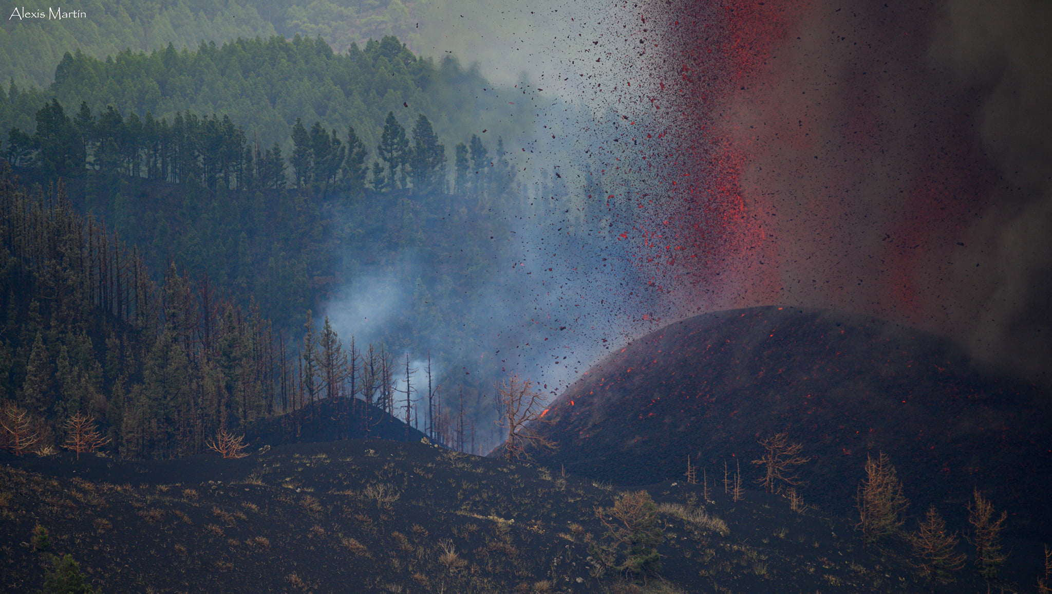
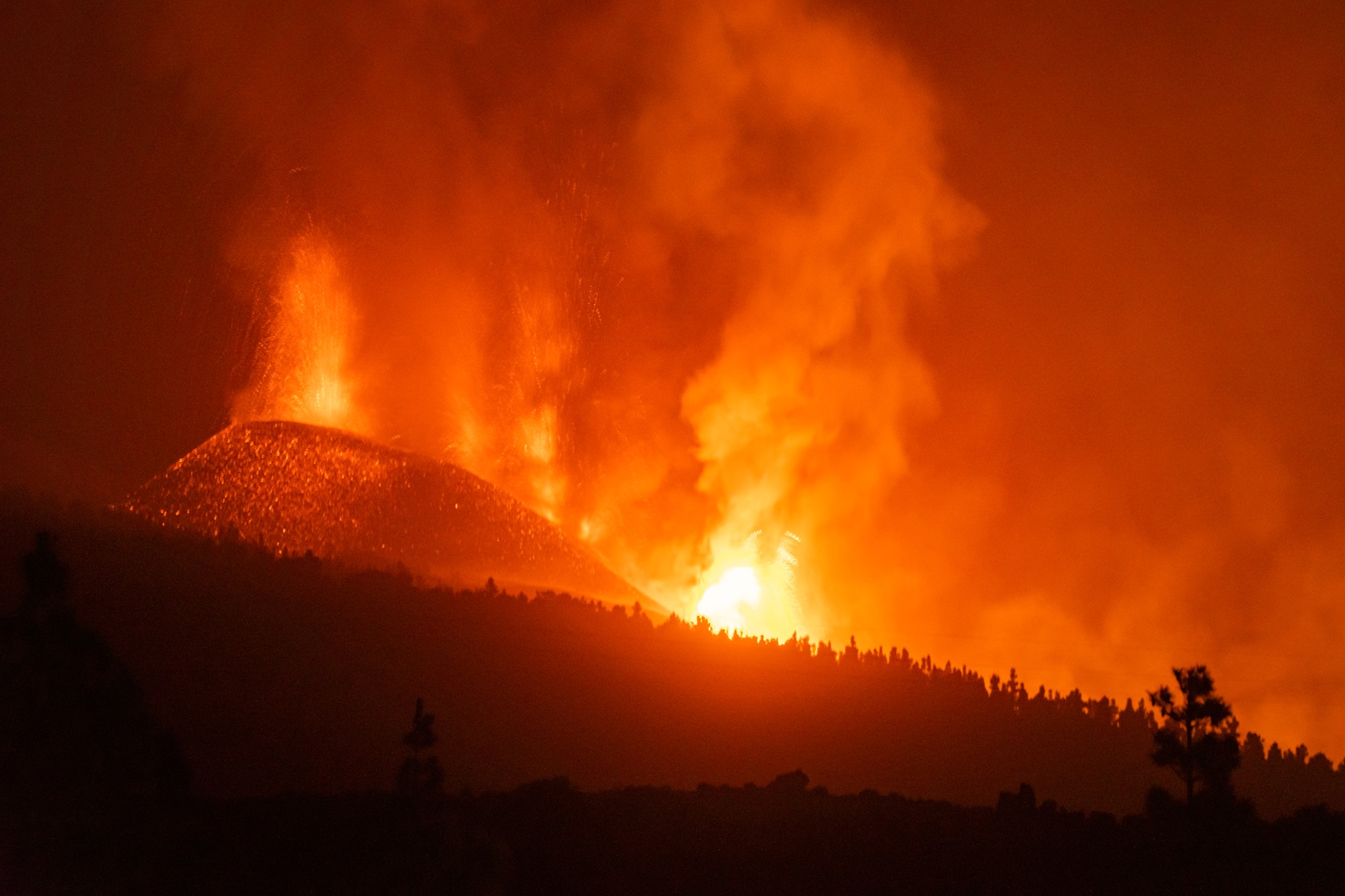
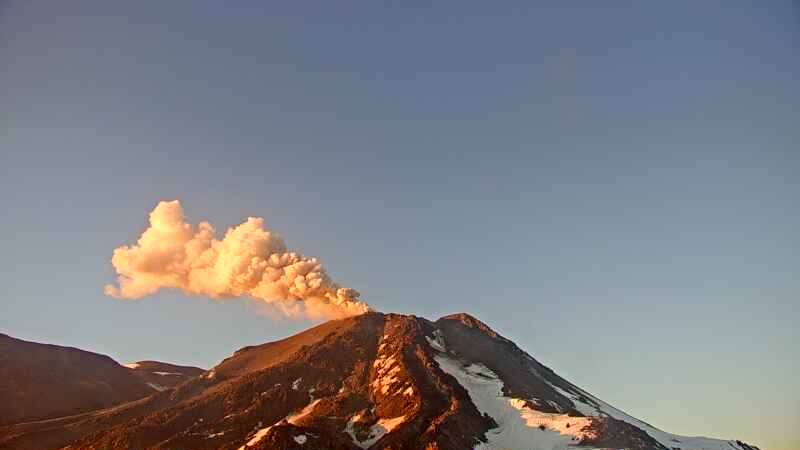
Eruptive activity continues on La Palma.
Since the last press release and until 24 hours yesterday, September 26, there was little seismicity in the eruptive zone, with a single localized earthquake, at 21:03 UTC of magnitude 2.5 (mbLg). Throughout this morning, between 4:00 a.m. and 7:00 a.m. UTC, a seismic swarm occurred in the area with 16 earthquakes located between 7 and 14 km deep.
The largest earthquake occurred at 06:05 UTC with a magnitude of 3.2 (mbLg). The value of the average amplitude of the volcanic tremor remained around the average values during the day yesterday and began to increase sharply from 21:00. It reached a maximum value at 00:00 today and from that time until 9:00 a.m. it dropped sharply, coinciding with the observations of a decrease in surface flow.
The network of permanent GNSS stations on the island shows a slight deflation in the vertical of LP03 and to a lesser extent in that of LP04. These results are compatible with those obtained using InSAR, in which no significant variation is observed between the Sentinel1 images of September 20 and 26.
This morning, due to the decrease in the emission of ash into the atmosphere, the IGN issued a VONA (Volcano Observatory Notice for Aviation) communicating this decrease and the decrease in the maximum height reached by the eruptive column in the different impulses. This VONA was sent, in accordance with the protocols of the International Civil Aviation, to the VAAC (Volcanic Ash Advisory Center) of Toulouse, to the ACC Canarias (Area Control Center) and to the AEMET (State Meteorological Agency).
IGN continues to monitor activity, having strengthened its presence on the island, where the CAVE (Center for Attention and Monitoring of Eruptions) has been established and works daily to collect samples of volcanic material for analysis. in situ and posterior.
The National Geographical Institute has confirmed that the volcano is currently exhibiting « pulses of columns of smoke and gas.
The agency also detected 16 earthquakes in the northern area of Fuencaliente, south of the volcano. The most intense was located at 6:05 am and at a depth of 10 kilometers, and in general all are above magnitude two and at depths between 9 and 13 kilometers.
This increase in seismicity may be due to the readjustment of the host rock in which the pocket of magma that flows from the new volcano is located or it may also be linked to the injection of new magma.
The volcano expelled some 46.3 million cubic meters of material
“The fissure eruption continues to show the same Strombolian mechanism since its inception as the one that focuses on the main cone. The process will continue to show pulses with increased volcanic activity and although there was a period when the Strombolian explosions ceased in the cone, it can happen again suddenly ”, explained Maria José Blanco, director of the Geophysical Center of Canaries, belonging to the National Geographic Institute (IGN).

The estimated total volume of material emitted in the streams and in the cone is approximately 46.3 million cubic meters. “The changes observed over the past few hours in the visible behavior of the rash may be related to a change in the conduit that feeds this emission. Blanco explained that the ash cloud will move south-east of the emitting center and could affect the area between La Palma, La Gomera and Tenerife in the coming days.
“There are two castings left. The southern one has very low speeds and the northern one was divided into two arms by the mountain of Todoque. Whoever goes north has found a less steep slope and has slowed down, and reconnects with the southward arm moving at a higher speed because it is in a hollow, ”Blanco detailed.
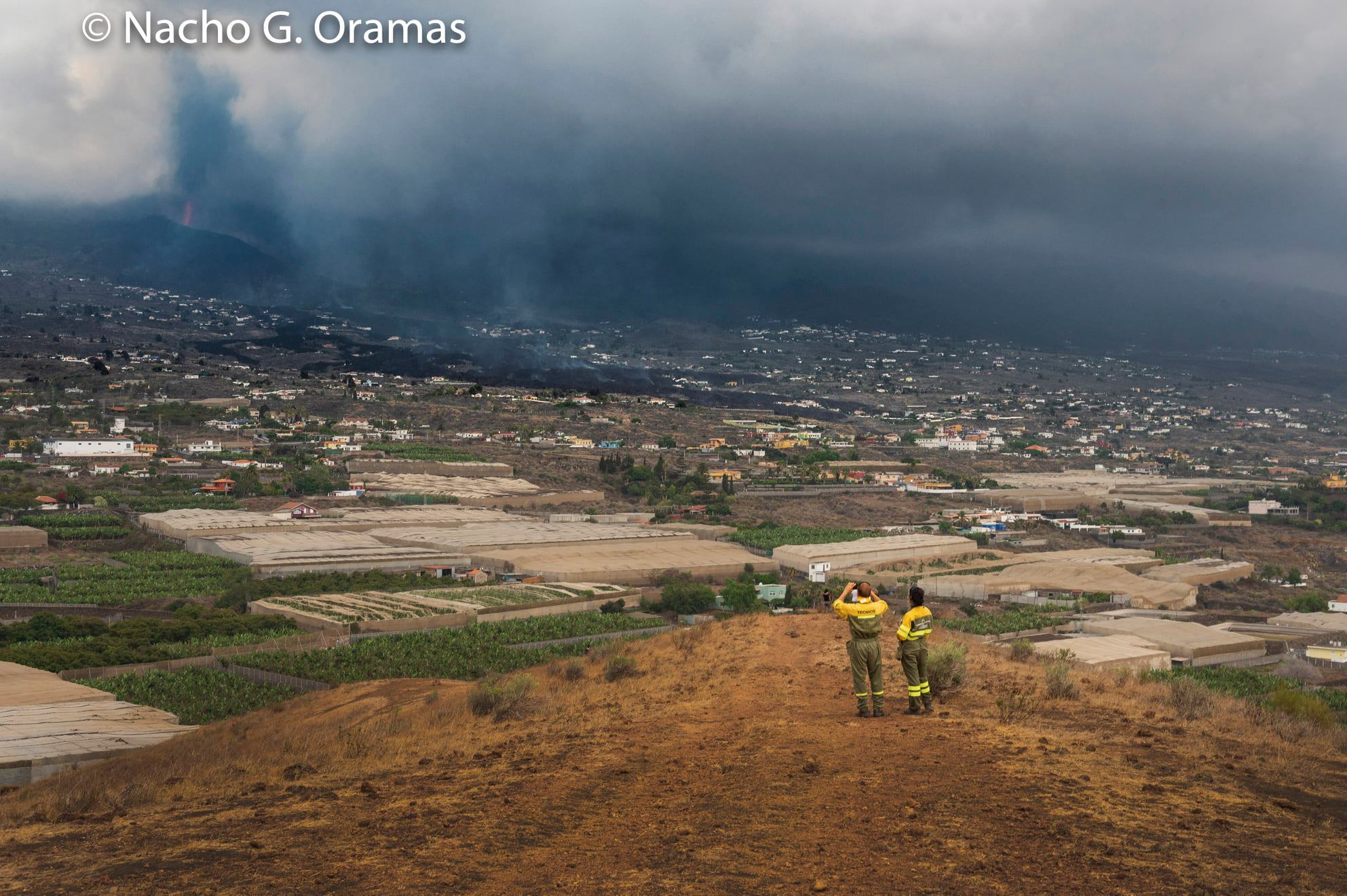
28/09: The lava flow that advances on Todoque towards the coast is already about 1,200 meters from the sea, according to government sources in the Canary Islands. Late Monday afternoon, a new flow of volcanic material came out of the main cone and descends above the previous flows with more speed, being more fluid. The Cumbre Vieja volcano again increased its explosions and lava emissions in the afternoon after several hours of relative inactivity, the National Geographic Institute (IGN) confirmed. In the morning there had been a brief halt in activity, during which the emission of lava, smoke and ash ceased. The management of the Canary Islands Volcanic Risk Prevention Plan (Pevolca) on Sunday evening ordered the containment of around 300 people from four neighborhoods in the municipality of Tazacorte if the lava ever reached the sea.
Source : IGN , El Pais.
Photos : Alexis Martin / Involcan , Volker Hildebrand , Nacho González Oramas Fotógrafo .
Carte : Copernicus .
Peru , Sabancaya :
Analysis period: September 20, 2021 to September 26, 2021, Arequipa, September 27, 2021.
Alert level: ORANGE
The Geophysical Institute of Peru (IGP) reports that the eruptive activity of the Sabancaya volcano remains at moderate levels, that is to say with the recording of an average of 29 daily explosions, with columns of ash and gas up to 2 km altitude above the summit of the volcano and their consequent dispersion. Therefore, for the following days, no significant change is expected in eruptive activity.
The IGP recorded and analyzed the occurrence of 1,067 earthquakes of volcanic origin, associated with the circulation of magmatic fluids within the Sabancaya volcano. An average of 29 explosions was recorded daily. During this period, Volcano-Tectonic (VT) earthquakes associated with rock fractures were located mainly in the North-East and East of Sabancaya and presented magnitudes between M2.0 and M4 , 5.
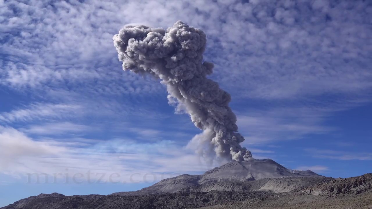
The monitoring of the deformation of the volcanic structure using GNSS techniques (processed with fast orbits) does not present any significant anomalies. However, in general, an inflation process was observed in the northern sector (around the Hualca Hualca volcano). Visual surveillance made it possible to identify columns of gas and ash up to 2 km altitude above the summit of the volcano, which were scattered towards the South, South-East, East, North-West, South – sectors. West and North-East of Sabancaya. Satellite recordings identified the presence of 1 thermal anomalies (maximum value of 3 MW) associated with the presence of a lava body on the surface of the volcano’s crater.
RECOMMENDATIONS
• Keep the volcanic alert level in orange.
• Do not approach within a radius of 12 km from the crater.
Source : IGP.
Photo : Martin Rietze.
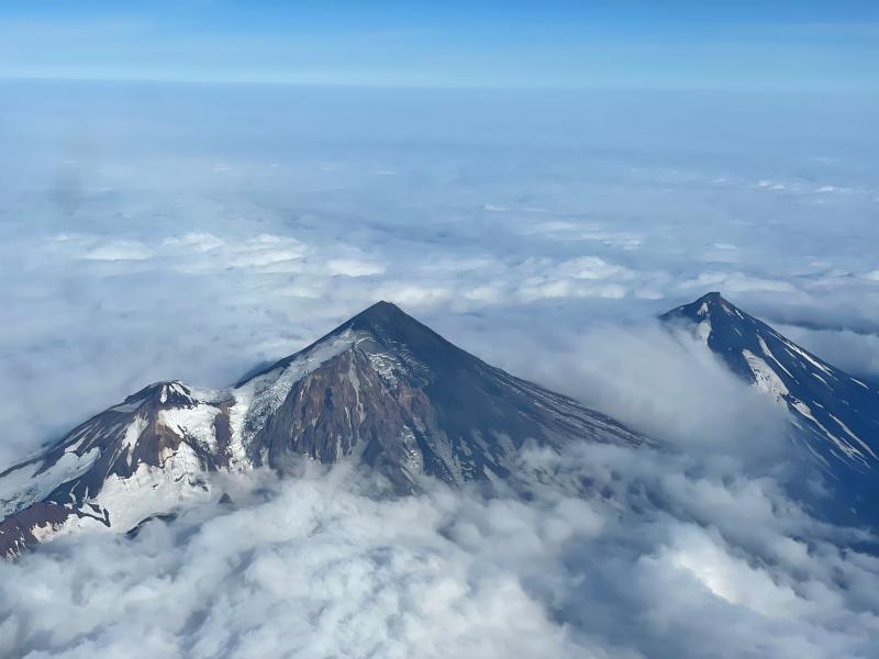
Alaska , Pavlof :
55°25’2″ N 161°53’37 » W,
Summit Elevation 8261 ft (2518 m)
Current Volcano Alert Level: WATCH
Current Aviation Color Code: ORANGE
Seismicity has remained elevated over the past day with small explosions detected in infrasound data last night at 20:16 ADKT (04:16 UTC) and this morning at 07:16 AKDT (15:16 UTC). A small ash emission was observed in the web camera imagery at 16:01 AKDT yesterday (September 27, 00:01 UTC). No activity was observed in partly cloudy satellite imagery.
Small explosions accompanied by low-level ash emissions could happen at any time, and are typically a hazard in the immediate vicinity of the summit. The level of unrest at Pavlof can change quickly and the progression to more significant eruptive activity can occur with little or no warning.
Pavlof Volcano is monitored by local seismic and infrasound sensors, satellite data, web cameras, and remote infrasound and lightning networks.
Source : AVO.
Photo : Ben David Jacob.
New Zealand , Ruapehu :
Mt Ruapehu status update: Crater Lake (Te Wai ā-moe) now cooling
Published: Tue Sep 28 2021 9:30 AM
Volcanic Alert Level remains at 1
Aviation Colour Code remains at Green
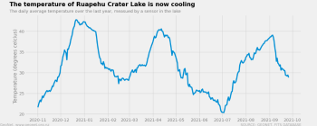
Another heating phase has passed at Mt Ruapehu. Over the last two months the temperature of Crater Lake (Te Wai ā-moe) rose from 20 °C to 39.5 °C, peaking on 4 September 2021, and has now cooled to 28 °C. The Volcanic Alert Level at Mt Ruapehu remains at Level 1.
Typically, over periods of months, Ruapehu’s Crater Lake (Te Wai ā-moe) undergoes heating and cooling cycles.
In late December 2020 the lake heated to 43 °C marking the high point of that cycle. Later in April of 2021 a 2nd cycle reached a maximum of 41 °C. The latest cycle is the third this year and the heating phase lasted from early July to early September 2021, during which the temperature rose from 20 °C to 39 °C.
The temperature of Ruapehu Crater Lake (Te Wai ā-moe) is now cooling

During the heating cycle the lake colour changed to a darker grey, from a blue-green colour. This is typical as sediments on the lake floor are disturbed during the influx of hot fluids and are suspended in the lake water.
The modelled heat flow into the lake has now dropped from 350-400 MW at the peak of the heating to around 200 MW (megawatt).
The lake is currently not overflowing into the Whangaehu river.
Routine monitoring at Mt Ruapehu includes gas measurement flights and Crater Lake (Te Wai ā-moe) water sampling.
The results from these visits and of our continuous monitoring of volcanic earthquake activity, tremor levels, and lake temperature and water level indicate that key monitoring parameters remain within normal ranges.
The Volcanic Alert Level stays at Level 1 which reflects the current level of volcanic unrest. The Volcanic Alert Level should not be used to forecast future activity.
The Aviation Colour Code remains at colour Green.
Mt Ruapehu is an active volcano and has the potential to erupt with little or no warning when in a state of volcanic unrest.
Volcanic Alert Level 1 indicates the primary hazards are those expected during volcanic unrest: steam discharge, volcanic gas, earthquakes, landslides and hydrothermal activity. While Volcanic Alert Level 1 is mostly associated with environmental hazards, eruptions can still occur with little or no warning.
GNS Science and the National Geohazards Monitoring Centre continue to closely monitor Mt Ruapehu for further changes.
Source : Geonet / Craig Miller / / Duty Volcanologist.
Photos : Bradd Scott , Geonet , Photovolcanica .
Chile / Argentina , Nevados de Chillan :
The seismicity parameters associated with the fracturing processes of rigid materials (type VT) remained at similar values compared to the previous period, while the events related to fluid dynamics (type LP, TR and EX) recorded a decrease in the amount and energy released, though, showing an intensification towards the end of the fortnight. It should be noted that during this fortnight there were harmonic tremor signals.
The highest energy VT-type event, with a local magnitude (ML) of 2.4, was located 4.3 km east-southeast (ESE) of the active crater and at a depth of 4 , 9 km.
From the analysis of the images provided by the surveillance cameras belonging to OVDAS as well as the satellite images, it can be seen that the advance of the L5 and L6 flows was practically zero, with slight variations observed at the beginning of the fortnight. The absence of recording of abnormal thermal radiance observed in the L5 and L6 flows shows their surface cooling. In turn, the location of a third lava dome stands out, which was located in the active crater towards the end of the period assessed in this report.

The explosive activity featured maximum column heights of 1060 m. When the weather conditions allowed it and during the beginning of the fortnight, it was possible to record columns of moderate height with a high pyroclast load. Towards the end of the analysis period, predominantly whitish columns were observed, highlighting the occurrence of isolated explosions with a strong load of brown pyroclastic material coming from the center of the crater. A pyroclastic flow was identified on September 3 in a northeast direction and with a range of 550 m. It was possible to record a low intensity incandescence during the night.
According to data obtained by the network of GNSS stations installed on the volcano, the low-magnitude inflationary process is maintained with maximum vertical deformation rates of 0.9 cm / month. The tracking baselines and horizontal components also recorded this process with slight changes in their behavior. The inclinometric stations remained stable except for changes due to climatic conditions.
Seven (7) thermal alerts were recorded in the area with a maximum value of 2 MW on September 15, considered low for this volcano. In turn, radiance anomalies were detected on September 10 and 15 from Sentinel 2-L2A image analysis.
Thermal imaging has observed maximum temperatures of 290 ° C in the emission zone during explosions and 60 ° C for the L5 and L6 lava flows.
Source : Segemar.
Photos : Cesar Lara Cancino , Segemar .