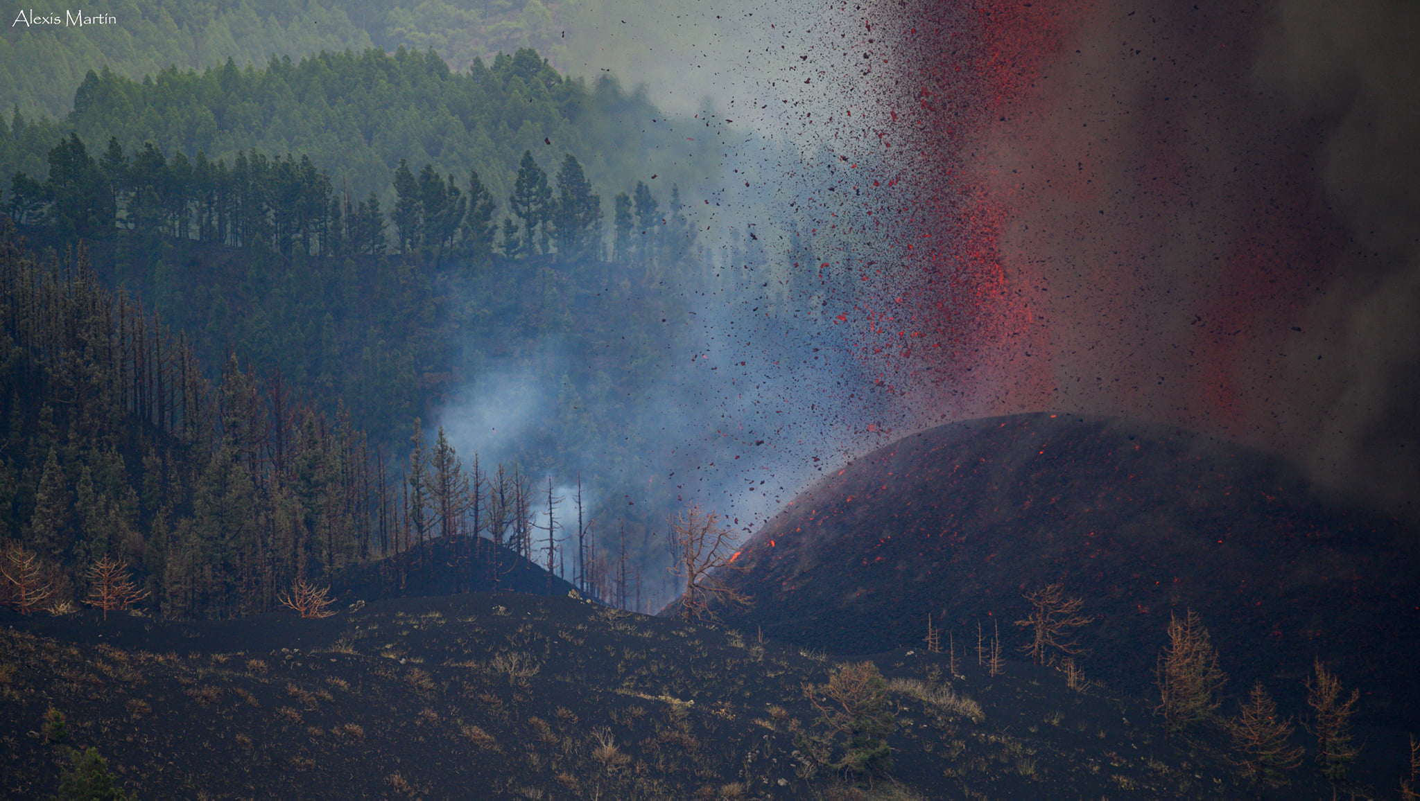
September 28, 2021. EN. Spain / La Palma : Cumbre Vieja , Peru : Sabancaya , Alaska : Pavlof , New Zealand : Ruapehu , Chile / Argentina : Nevados de Chillan .

September 28 , 2021.


Spain / La Palma , Cumbre Vieja :

September 27, 2021, 11:00 UTC.

Eruptive activity continues on La Palma.
Since the last press release and until 24 hours yesterday, September 26, there was little seismicity in the eruptive zone, with a single localized earthquake, at 21:03 UTC of magnitude 2.5 (mbLg). Throughout this morning, between 4:00 a.m. and 7:00 a.m. UTC, a seismic swarm occurred in the area with 16 earthquakes located between 7 and 14 km deep.

The largest earthquake occurred at 06:05 UTC with a magnitude of 3.2 (mbLg). The value of the average amplitude of the volcanic tremor remained around the average values during the day yesterday and began to increase sharply from 21:00. It reached a maximum value at 00:00 today and from that time until 9:00 a.m. it dropped sharply, coinciding with the observations of a decrease in surface flow.

The network of permanent GNSS stations on the island shows a slight deflation in the vertical of LP03 and to a lesser extent in that of LP04. These results are compatible with those obtained using InSAR, in which no significant variation is observed between the Sentinel1 images of September 20 and 26.

This morning, due to the decrease in the emission of ash into the atmosphere, the IGN issued a VONA (Volcano Observatory Notice for Aviation) communicating this decrease and the decrease in the maximum height reached by the eruptive column in the different impulses. This VONA was sent, in accordance with the protocols of the International Civil Aviation, to the VAAC (Volcanic Ash Advisory Center) of Toulouse, to the ACC Canarias (Area Control Center) and to the AEMET (State Meteorological Agency).

IGN continues to monitor activity, having strengthened its presence on the island, where the CAVE (Center for Attention and Monitoring of Eruptions) has been established and works daily to collect samples of volcanic material for analysis. in situ and posterior.


The National Geographical Institute has confirmed that the volcano is currently exhibiting « pulses of columns of smoke and gas.

The agency also detected 16 earthquakes in the northern area of ​​Fuencaliente, south of the volcano. The most intense was located at 6:05 am and at a depth of 10 kilometers, and in general all are above magnitude two and at depths between 9 and 13 kilometers.

This increase in seismicity may be due to the readjustment of the host rock in which the pocket of magma that flows from the new volcano is located or it may also be linked to the injection of new magma.

The volcano expelled some 46.3 million cubic meters of material

“The fissure eruption continues to show the same Strombolian mechanism since its inception as the one that focuses on the main cone. The process will continue to show pulses with increased volcanic activity and although there was a period when the Strombolian explosions ceased in the cone, it can happen again suddenly ”, explained Maria José Blanco, director of the Geophysical Center of Canaries, belonging to the National Geographic Institute (IGN).

The estimated total volume of material emitted in the streams and in the cone is approximately 46.3 million cubic meters. “The changes observed over the past few hours in the visible behavior of the rash may be related to a change in the conduit that feeds this emission. Blanco explained that the ash cloud will move south-east of the emitting center and could affect the area between La Palma, La Gomera and Tenerife in the coming days.

“There are two castings left. The southern one has very low speeds and the northern one was divided into two arms by the mountain of Todoque. Whoever goes north has found a less steep slope and has slowed down, and reconnects with the southward arm moving at a higher speed because it is in a hollow, ”Blanco detailed.

28/09: The lava flow that advances on Todoque towards the coast is already about 1,200 meters from the sea, according to government sources in the Canary Islands. Late Monday afternoon, a new flow of volcanic material came out of the main cone and descends above the previous flows with more speed, being more fluid. The Cumbre Vieja volcano again increased its explosions and lava emissions in the afternoon after several hours of relative inactivity, the National Geographic Institute (IGN) confirmed. In the morning there had been a brief halt in activity, during which the emission of lava, smoke and ash ceased. The management of the Canary Islands Volcanic Risk Prevention Plan (Pevolca) on Sunday evening ordered the containment of around 300 people from four neighborhoods in the municipality of Tazacorte if the lava ever reached the sea.

Source : IGN , El Pais.

Photos : Alexis Martin / Involcan , Volker Hildebrand , Nacho González Oramas Fotógrafo .

Carte : Copernicus .


Peru , Sabancaya :

Analysis period: September 20, 2021 to September 26, 2021, Arequipa, September 27, 2021.
Alert level: ORANGE

The Geophysical Institute of Peru (IGP) reports that the eruptive activity of the Sabancaya volcano remains at moderate levels, that is to say with the recording of an average of 29 daily explosions, with columns of ash and gas up to 2 km altitude above the summit of the volcano and their consequent dispersion. Therefore, for the following days, no significant change is expected in eruptive activity.

The IGP recorded and analyzed the occurrence of 1,067 earthquakes of volcanic origin, associated with the circulation of magmatic fluids within the Sabancaya volcano. An average of 29 explosions was recorded daily. During this period, Volcano-Tectonic (VT) earthquakes associated with rock fractures were located mainly in the North-East and East of Sabancaya and presented magnitudes between M2.0 and M4 , 5.

The monitoring of the deformation of the volcanic structure using GNSS techniques (processed with fast orbits) does not present any significant anomalies. However, in general, an inflation process was observed in the northern sector (around the Hualca Hualca volcano). Visual surveillance made it possible to identify columns of gas and ash up to 2 km altitude above the summit of the volcano, which were scattered towards the South, South-East, East, North-West, South – sectors. West and North-East of Sabancaya. Satellite recordings identified the presence of 1 thermal anomalies (maximum value of 3 MW) associated with the presence of a lava body on the surface of the volcano’s crater.

RECOMMENDATIONS
• Keep the volcanic alert level in orange.
• Do not approach within a radius of 12 km from the crater.

Source : IGP.

Photo : Martin Rietze.


Alaska , Pavlof :

55°25’2″ N 161°53’37 » W,
Summit Elevation 8261 ft (2518 m)
Current Volcano Alert Level: WATCH
Current Aviation Color Code: ORANGE

Seismicity has remained elevated over the past day with small explosions detected in infrasound data last night at 20:16 ADKT (04:16 UTC) and this morning at 07:16 AKDT (15:16 UTC). A small ash emission was observed in the web camera imagery at 16:01 AKDT yesterday (September 27, 00:01 UTC). No activity was observed in partly cloudy satellite imagery.

Small explosions accompanied by low-level ash emissions could happen at any time, and are typically a hazard in the immediate vicinity of the summit. The level of unrest at Pavlof can change quickly and the progression to more significant eruptive activity can occur with little or no warning.

Pavlof Volcano is monitored by local seismic and infrasound sensors, satellite data, web cameras, and remote infrasound and lightning networks.

Source : AVO.

Photo : Ben David Jacob.


New Zealand , Ruapehu :

Mt Ruapehu status update: Crater Lake (Te Wai ā-moe) now cooling
Published: Tue Sep 28 2021 9:30 AM

Volcanic Alert Level remains at 1
Aviation Colour Code remains at Green
Another heating phase has passed at Mt Ruapehu. Over the last two months the temperature of Crater Lake (Te Wai ā-moe) rose from 20 °C to 39.5 °C, peaking on 4 September 2021, and has now cooled to 28 °C. The Volcanic Alert Level at Mt Ruapehu remains at Level 1.
Typically, over periods of months, Ruapehu’s Crater Lake (Te Wai ā-moe) undergoes heating and cooling cycles.

In late December 2020 the lake heated to 43 °C marking the high point of that cycle. Later in April of 2021 a 2nd cycle reached a maximum of 41 °C. The latest cycle is the third this year and the heating phase lasted from early July to early September 2021, during which the temperature rose from 20 °C to 39 °C.
The temperature of Ruapehu Crater Lake (Te Wai ā-moe) is now cooling

During the heating cycle the lake colour changed to a darker grey, from a blue-green colour. This is typical as sediments on the lake floor are disturbed during the influx of hot fluids and are suspended in the lake water.
The modelled heat flow into the lake has now dropped from 350-400 MW at the peak of the heating to around 200 MW (megawatt).
The lake is currently not overflowing into the Whangaehu river.

Routine monitoring at Mt Ruapehu includes gas measurement flights and Crater Lake (Te Wai ā-moe) water sampling.

The results from these visits and of our continuous monitoring of volcanic earthquake activity, tremor levels, and lake temperature and water level indicate that key monitoring parameters remain within normal ranges.

The Volcanic Alert Level stays at Level 1 which reflects the current level of volcanic unrest. The Volcanic Alert Level should not be used to forecast future activity.

The Aviation Colour Code remains at colour Green.

Mt Ruapehu is an active volcano and has the potential to erupt with little or no warning when in a state of volcanic unrest.

Volcanic Alert Level 1 indicates the primary hazards are those expected during volcanic unrest: steam discharge, volcanic gas, earthquakes, landslides and hydrothermal activity. While Volcanic Alert Level 1 is mostly associated with environmental hazards, eruptions can still occur with little or no warning.

GNS Science and the National Geohazards Monitoring Centre continue to closely monitor Mt Ruapehu for further changes.

Source : Geonet / Craig Miller / / Duty Volcanologist.

Photos : Bradd Scott , Geonet , Photovolcanica .


Chile / Argentina , Nevados de Chillan :

The seismicity parameters associated with the fracturing processes of rigid materials (type VT) remained at similar values ​​compared to the previous period, while the events related to fluid dynamics (type LP, TR and EX) recorded a decrease in the amount and energy released, though, showing an intensification towards the end of the fortnight. It should be noted that during this fortnight there were harmonic tremor signals.
The highest energy VT-type event, with a local magnitude (ML) of 2.4, was located 4.3 km east-southeast (ESE) of the active crater and at a depth of 4 , 9 km.
From the analysis of the images provided by the surveillance cameras belonging to OVDAS as well as the satellite images, it can be seen that the advance of the L5 and L6 flows was practically zero, with slight variations observed at the beginning of the fortnight. The absence of recording of abnormal thermal radiance observed in the L5 and L6 flows shows their surface cooling. In turn, the location of a third lava dome stands out, which was located in the active crater towards the end of the period assessed in this report.

The explosive activity featured maximum column heights of 1060 m. When the weather conditions allowed it and during the beginning of the fortnight, it was possible to record columns of moderate height with a high pyroclast load. Towards the end of the analysis period, predominantly whitish columns were observed, highlighting the occurrence of isolated explosions with a strong load of brown pyroclastic material coming from the center of the crater. A pyroclastic flow was identified on September 3 in a northeast direction and with a range of 550 m. It was possible to record a low intensity incandescence during the night.

According to data obtained by the network of GNSS stations installed on the volcano, the low-magnitude inflationary process is maintained with maximum vertical deformation rates of 0.9 cm / month. The tracking baselines and horizontal components also recorded this process with slight changes in their behavior. The inclinometric stations remained stable except for changes due to climatic conditions.

Seven (7) thermal alerts were recorded in the area with a maximum value of 2 MW on September 15, considered low for this volcano. In turn, radiance anomalies were detected on September 10 and 15 from Sentinel 2-L2A image analysis.
Thermal imaging has observed maximum temperatures of 290 ° C in the emission zone during explosions and 60 ° C for the L5 and L6 lava flows.

Source : Segemar.

Photos : Cesar Lara Cancino , Segemar .


28 Septembre 2021. FR. Espagne / La Palma : Cumbre Vieja , Pérou : Sabancaya , Alaska : Pavlof , Nouvelle Zélande : Ruapehu , Chili / Argentine : Nevados de Chillan .

28 Septembre 2021.


Espagne / La Palma , Cumbre Vieja :

27 Septembre 2021 , 11h00 UTC.

L’activité éruptive se poursuit sur La Palma.
Depuis le dernier communiqué et jusqu’à 24 heures hier 26 septembre, il y a eu peu de sismicité dans la zone éruptive, avec un seul séisme localisé ,à 21h03 UTC de magnitude 2,5 (mbLg). Tout au long de cette matinée, entre 4h00 et 7h00 UTC, un essaim sismique a eu lieu dans la zone avec 16 séismes situés entre 7 et 14 km de profondeur.

Le plus grand séisme s’est produit à 06h05 UTC avec une magnitude de 3,2 (mbLg). La valeur de l’amplitude moyenne du tremor volcanique est restée autour des valeurs moyennes durant la journée d’hier et a commencé à augmenter fortement à partir de 21h00. Il a atteint une valeur maximale à 00h00 aujourd’hui et à partir de ce moment jusqu’à 9h00 du matin, il a fortement chuté, coïncidant avec les observations d’une diminution du débit de surface.

Le réseau de stations GNSS permanentes de l’île montre une légère déflation dans la verticale de LP03 et dans une moindre mesure dans celle de LP04. Ces résultats sont compatibles avec ceux obtenus à l’aide d’InSAR, dans lesquels aucune variation significative n’est observée entre les images Sentinel1 des 20 et 26 septembre.

Ce matin, en raison de la diminution de l’émission de cendres dans l’atmosphère, l’IGN a émis un VONA (Volcano Observatory Notice for Aviation) communiquant cette diminution et la diminution de la hauteur maximale atteinte par la colonne éruptive dans les différentes impulsions. Ce VONA a été envoyé, conformément aux protocoles de l’Aviation Civile Internationale, au VAAC (Volcanic Ash Advisory Center) de Toulouse, à l’ACC Canarias (Area Control Center) et à l’AEMET (State Meteorological Agency).

L’IGN continue de surveiller l’activité, ayant renforcé sa présence sur l’île, où le CAVE (Centre d’Attention et de Surveillance des Eruptions) a été implanté et travaille quotidiennement à la collecte d’échantillons de matériel volcanique pour analyse in situ et postérieure.


L’Institut géographique national a confirmé que le volcan présente actuellement « des impulsions de colonnes de fumée et de gaz.

L’agence a également détecté 16 tremblements de terre dans la zone Nord de Fuencaliente, au Sud du volcan. Le plus intense a été localisé à 06h05 et à une profondeur de 10 kilomètres, et en général, tous sont au-dessus de la magnitude deux et à des profondeurs comprises entre 9 et 13 kilomètres.

Cette augmentation de la sismicité peut être due au réajustement de la roche encaissante dans laquelle se trouve la poche de magma qui s’écoule du nouveau volcan ou elle peut également être liée à l’injection de nouveau magma .  

Le volcan a expulsé quelque 46,3 millions de mètres cubes de matériaux

« L’éruption fissurale continue de montrer le même mécanisme strombolien depuis sa création que celui qui se concentre sur le cône principal. Le processus continuera à montrer des impulsions avec une activité volcanique accrue et bien qu’il y ait eu une période où les explosions stromboliennes ont cessé dans le cône, cela peut se reproduire brusquement », a expliqué Maria José Blanco, directrice du Centre géophysique des Canaries, appartenant à l’Institut géographique national (IGN).

L’estimation du volume total de matières émises en coulées et dans le cône est d’environ 46,3 millions de mètres cubes. « Les changements observés au cours des dernières heures dans le comportement visible de l’éruption peuvent être liés à un changement dans le conduit qui alimente cette émission. » Blanco a expliqué que le nuage de cendres se déplacera vers le Sud-Est du centre émetteur et pourrait affecter la zone entre La Palma, La Gomera et Tenerife dans les prochains jours.

« Il reste deux coulées. Celle du Sud a des vitesses très basses et celle du Nord a été divisée en deux bras par la montagne de Todoque. Celui qui va dans le Nord a trouvé une pente moins importante et a ralenti,  et se reconnecte avec le bras qui va vers le Sud qui avance à une vitesse plus élevée parce qu’il est dans un creux », a détaillé Blanco.

28/09 : La coulée de lave qui avance sur Todoque en direction de la côte se trouve déjà à environ 1200 mètres de la mer, selon des sources gouvernementales des Canaries. Lundi en fin d’après-midi, un nouveau flux de matière volcanique est sorti du cône principal et descend au-dessus des coulées précédentes avec plus de vitesse, étant plus fluide. Le volcan de Cumbre Vieja a de nouveau augmenté ses explosions et ses émissions de lave dans l’après-midi après plusieurs heures d’inactivité relative, a confirmé l’Institut géographique national (IGN). Dans la matinée, il y avait eu un bref arrêt de l’activité, au cours duquel l’émission de lave, de fumée et de cendres a cessé. La direction du Plan de prévention des risques volcaniques des Canaries (Pevolca) a ordonné dimanche soir le confinement d’environ 300 personnes de quatre quartiers de la municipalité de Tazacorte si jamais la lave atteignait la mer.

Source : IGN , El Pais.

Photos : Alexis Martin / Involcan , Volker Hildebrand , Nacho González Oramas Fotógrafo .

Carte : Copernicus .


Pérou , Sabancaya :

Période d’analyse: du 20 Septembre 2021 au 26 Septembre 2021 , Arequipa, 27 Septembre 2021.
Niveau d’alerte: ORANGE

L’Institut géophysique du Pérou (IGP) rapporte que l’activité éruptive du volcan Sabancaya reste à des niveaux modérés, c’est-à-dire avec l’enregistrement d’une moyenne de 29 explosions quotidiennes , avec des colonnes de cendres et de gaz jusqu’à 2 km d’altitude au dessus du sommet du volcan et leur dispersion consécutives . Par conséquent, pour les jours suivants, aucun changement significatif n’est attendu concernant l’ activité éruptive.


L’IGP a enregistré et analysé l’occurrence de 1067 tremblements de terre d’origine volcanique, associés à la circulation de fluides magmatiques à l’intérieur du volcan Sabancaya. Une moyenne de 29 explosions a été enregistrée quotidiennement . Au cours de cette période, les tremblements de terre de type Volcano-Tectoniques (VT) associés à des fracturations rocheuses ont été localisés principalement dans le Nord-Est et l’Est du Sabancaya et ont présenté des magnitudes comprises entre M2,0 et M4,5. 

Le suivi de la déformation de la structure volcanique à l’aide de techniques GNSS (traitées avec des orbites rapides) ne présente pas d’anomalies significatives. Cependant, de manière générale, un processus d’inflation a été observé dans le secteur  Nord ( environs du volcan Hualca Hualca ). La surveillance visuelle a permis d’identifier des colonnes de gaz et de cendres jusqu’à 2  km d’altitude au dessus du sommet du volcan , qui étaient dispersées vers les secteurs Sud , Sud-Est ,  Est , Nord- Ouest , Sud – Ouest et Nord- Est du Sabancaya.  Les enregistrements par satellites ont identifiés la présence de 1 anomalies thermiques ( valeur maximale de 3 MW ) associées à la présence d’un corps de lave à la superficie du cratère du volcan  . 

RECOMMANDATIONS
• Garder le niveau d’alerte volcanique en orange.
• Ne pas s’ approcher dans un rayon de moins de 12 km du cratère.

Source : IGP.

Photo : Martin Rietze.


Alaska , Pavlof :

55°25’2″ N 161°53’37 » O,
Altitude du sommet : 8261 pi (2518 m)
Niveau d’alerte volcan actuel : ATTENTION
Code couleur aviation actuel : ORANGE

La sismicité est restée élevée au cours de la dernière journée avec de petites explosions détectées dans les données infrasons la nuit dernière à 20h16 ADKT (04h16 UTC) et ce matin à 07h16 AKDT (15h16 UTC). Une petite émission de cendres a été observée dans les images de la caméra Web à 16h01 AKDT hier (27 septembre à 00h01 UTC). Aucune activité n’a été observée sur les images satellites partiellement nuageuses.

De petites explosions accompagnées d’émissions de cendres de faible niveau peuvent se produire à tout moment et constituent généralement un danger à proximité immédiate du sommet. Le niveau d’agitation du Pavlof peut changer rapidement et la progression vers une activité éruptive plus importante peut se produire avec peu ou pas d’avertissement.

Le volcan Pavlof est surveillé par des capteurs sismiques et infrasons locaux, des données satellitaires, des caméras Web et des réseaux distants de capteurs d’infrasons et de foudre.

Source : AVO.

Photo : Ben David Jacob.


Nouvelle Zélande , Ruapehu :

Mise à jour du statut d’activité du mont Ruapehu : le lac du cratère (Te Wai ā-moe) se refroidit maintenant
Publié: mar. 28 sept. 2021 09:30

Le niveau d’alerte volcanique reste à 1
Le code couleur de l’aviation reste au vert
Une autre phase de chauffage est passée sur le mont Ruapehu. Au cours des deux derniers mois, la température du lac du cratère (Te Wai ā-moe) est passée de 20 °C à 39,5 °C, culminant le 4 septembre 2021, et s’est maintenant refroidie à 28 °C. Le niveau d’alerte volcanique au mont Ruapehu reste au niveau 1.
En règle générale, sur des périodes de plusieurs mois, le lac du cratère du Ruapehu (Te Wai ā-moe) subit des cycles de chauffage et de refroidissement.

Fin décembre 2020, le lac s’est réchauffé à 43 °C, marquant le point culminant de ce cycle. Plus tard en avril 2021, un 2e cycle a atteint un maximum de 41 °C. Le dernier cycle est le troisième cette année et la phase de chauffe a duré de début juillet à début septembre 2021, durant laquelle la température est passée de 20 °C à 39 °C.
La température du lac du cratère Ruapehu (Te Wai ā-moe) se refroidit maintenant.

Pendant le cycle de chauffage, la couleur du lac est passée à un gris plus foncé, passant par une couleur bleu-vert. Ceci est typique car les sédiments au fond du lac sont perturbés lors de l’afflux de fluides chauds et sont en suspension dans l’eau du lac.
Le flux de chaleur modélisé dans le lac est maintenant passé de 350 à 400 MW au pic du chauffage à environ 200 MW (mégawatt).
Le lac ne déborde actuellement pas dans la rivière Whangaehu.

La surveillance de routine du mont Ruapehu comprend des vols de mesure de gaz et un échantillonnage de l’eau du lac Crater (Te Wai ā-moe).

Les résultats de ces visites et de notre surveillance continue de l’activité sismique volcanique, des niveaux de tremors, de la température du lac et du niveau d’eau indiquent que les principaux paramètres de surveillance restent dans les limites normales.

Le niveau d’alerte volcanique reste au niveau 1, ce qui reflète le niveau actuel de troubles volcaniques. Le niveau d’alerte volcanique ne doit pas être utilisé pour prévoir une activité future.

Le code de couleur de l’aviation reste à la couleur verte.

Le mont Ruapehu est un volcan actif et a le potentiel d’entrer en éruption avec peu ou pas d’avertissement lorsqu’il est dans un état d’agitation volcanique.

Le niveau d’alerte volcanique 1 indique que les principaux dangers sont ceux attendus pendant les troubles volcaniques : décharges de vapeur, gaz volcaniques, tremblements de terre, glissements de terrain et activité hydrothermale. Bien que le niveau d’alerte volcanique 1 soit principalement associé à des dangers environnementaux, des éruptions peuvent toujours se produire avec peu ou pas d’avertissement.

Le GNS Science et le Centre national de surveillance des géorisques continuent de surveiller de près le mont Ruapehu pour d’autres changements.

Source : Geonet / Craig Miller / Volcanologue de service.

Photos : Bradd Scott , Geonet , Photovolcanica .


Chili / Argentine , Nevados de Chillan :

Les paramètres de sismicité associés aux processus de fracturation des matériaux rigides (type VT) sont restés à des valeurs similaires par rapport à la période précédente, tandis que les événements liés à la dynamique des fluides (type LP, TR et EX) ont enregistré une diminution de la quantité et de l’énergie libérée, bien que, présentant une intensification vers la fin de la quinzaine. Il est à noter que durant cette quinzaine il y a eu des signaux de tremor harmoniques.
L’événement de type VT de plus haute énergie, avec une magnitude locale (ML) de 2,4, était situé à 4,3 km à l’Est-Sud-Est (ESE) du cratère actif et à une profondeur de 4,9 km.
A partir de l’analyse des images fournies par les caméras de surveillance appartenant à OVDAS ainsi que des images satellitaires, on constate que l’avance des flux L5 et L6 était pratiquement nulle, avec de faibles variations observées en début de quinzaine. L’absence d’enregistrement de radiance thermique anormale observée dans les écoulements L5 et L6 montre leur refroidissement superficiel. À son tour, l’emplacement d’un troisième dôme de lave se démarque, qui a été localisé dans le cratère actif vers la fin de la période évaluée dans ce rapport.

L’activité explosive a présenté des hauteurs de colonnes maximales de 1060 m. Lorsque les conditions météorologiques le permettaient et durant le début de la quinzaine, il a été possible d’enregistrer des colonnes de hauteur modérée avec une forte charge en pyroclastes. Vers la fin de la période d’analyse, des colonnes majoritairement blanchâtres ont été observées, mettant en évidence l’occurrence d’explosions isolées avec une forte charge de matériau pyroclastique brun provenant du centre du cratère. Une coulée pyroclastique a été identifiée le 3 septembre dans une direction Nord-Est et d’une portée de 550 m. Il a été possible d’enregistrer une incandescence de faible intensité pendant la nuit.

Selon les données obtenues par le réseau de stations GNSS installées sur le volcan, le processus inflationniste de faible magnitude se maintient avec des taux de déformation verticale maximale de 0,9 cm/mois. Les lignes de base de suivi et les composantes horizontales ont également enregistré ce processus avec de légers changements dans leur comportement. Les stations inclinométriques sont restées stables à l’exception des changements dus aux conditions climatiques.

Sept (7) alertes thermiques ont été enregistrées dans la zone avec une valeur maximale de 2 MW le 15 septembre, considérée comme faible pour ce volcan. À leur tour, des anomalies de radiance ont été détectées les 10 et 15 septembre à partir de l’analyse d’images Sentinel 2-L2A.
L’imagerie thermique a permis d’observer des températures maximales de 290°C dans la zone d’émission lors des explosions et de 60°C pour les coulées de lave L5 et L6.

Source : Segemar.

Photos : Cesar Lara Cancino , Segemar .