November 08 , 2022.
Alaska , Semisopochnoi :
AVO/USGS Volcanic Activity Notice
Current Volcano Alert Level: WATCH
Previous Volcano Alert Level: ADVISORY
Current Aviation Color Code: ORANGE
Previous Aviation Color Code: YELLOW
Issued: Monday, November 7, 2022, 1:08 PM AKST
Source: Alaska Volcano Observatory
Notice Number: 2022/A1242
Location: N 51 deg 55 min E 179 deg 35 min
Elevation: 2625 ft (800 m)
Area: Aleutians
Volcanic Activity Summary:
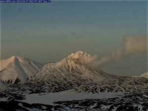
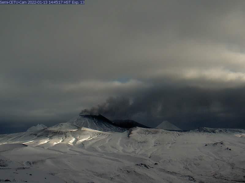
Small explosions have been detected in geophysical data over the past week from the north crater of Mount Cerberus at Semisopochnoi. In addition, volcanic tremor has resumed during the same time period. Ash emissions have not been observed. However, the type of unrest we detected was associated with ash emissions during previous periods of unrest and, if occurring, such ash emissions are likely below 10,000 ft above sea level. These events are similar to eruptive activity observed over the last year at Semisopochnoi, but not since September 14. The Aviation Color Code and Volcano Alert Level are being raised to ORANGE/WATCH.
Small eruptions producing minor ash deposits within the vicinity of the active north crater of Mount Cerberus and ash clouds usually under 10,000 ft (3 km) above sea level have characterized the recent activity and more ash-producing events could occur again with little warning.
Semisopochnoi is monitored by a local seismic and infrasound network, local web cameras, regional lightning and infrasound sensors, and satellite data.
Recent Observations:
[Volcanic cloud height] less than 10,000 ft. above sea level
[Other volcanic cloud information] none
[Ballistics] none
[Lava flow/dome] none
[Lava flow] none
Remarks:
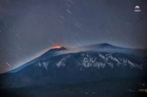
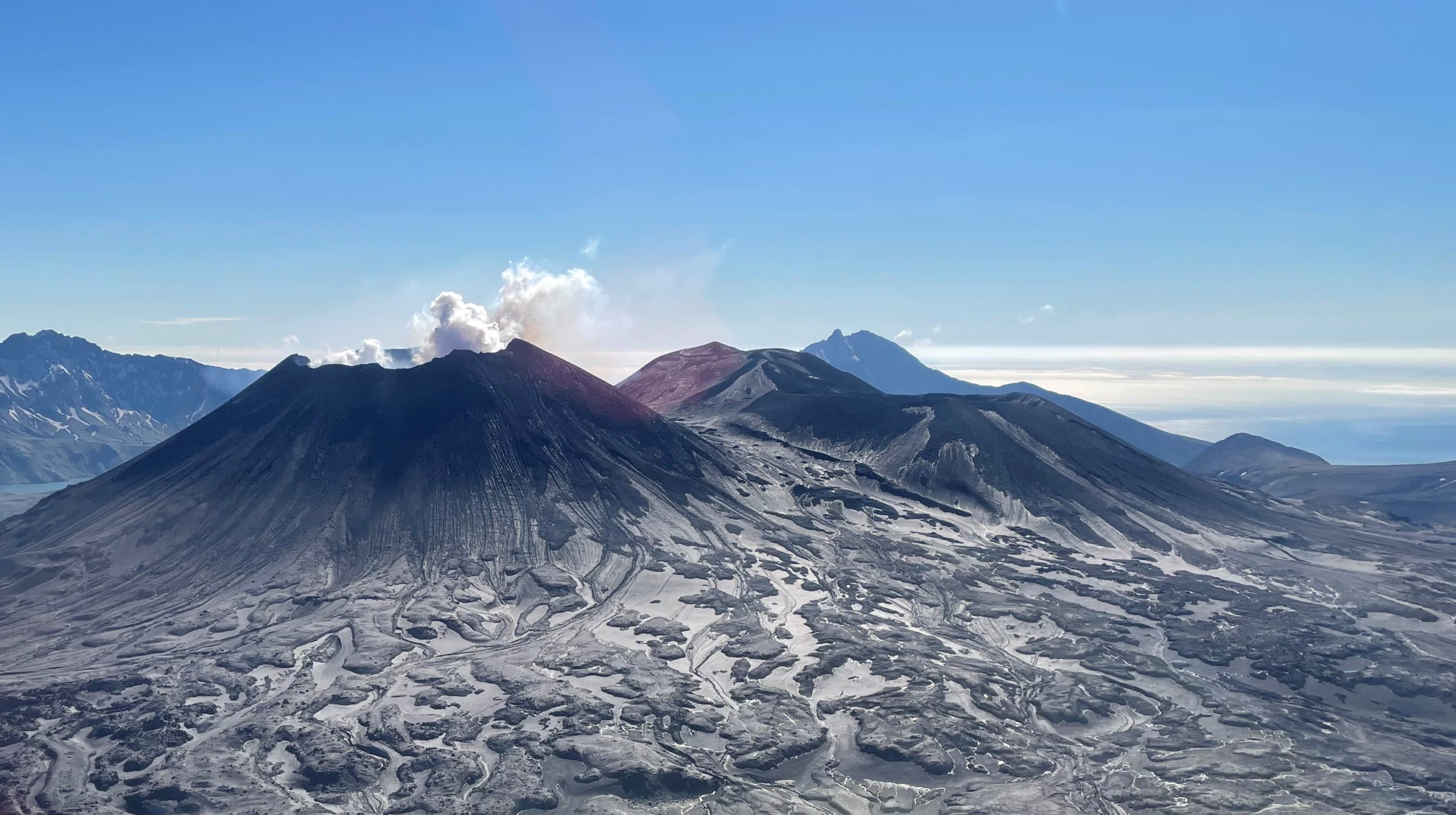
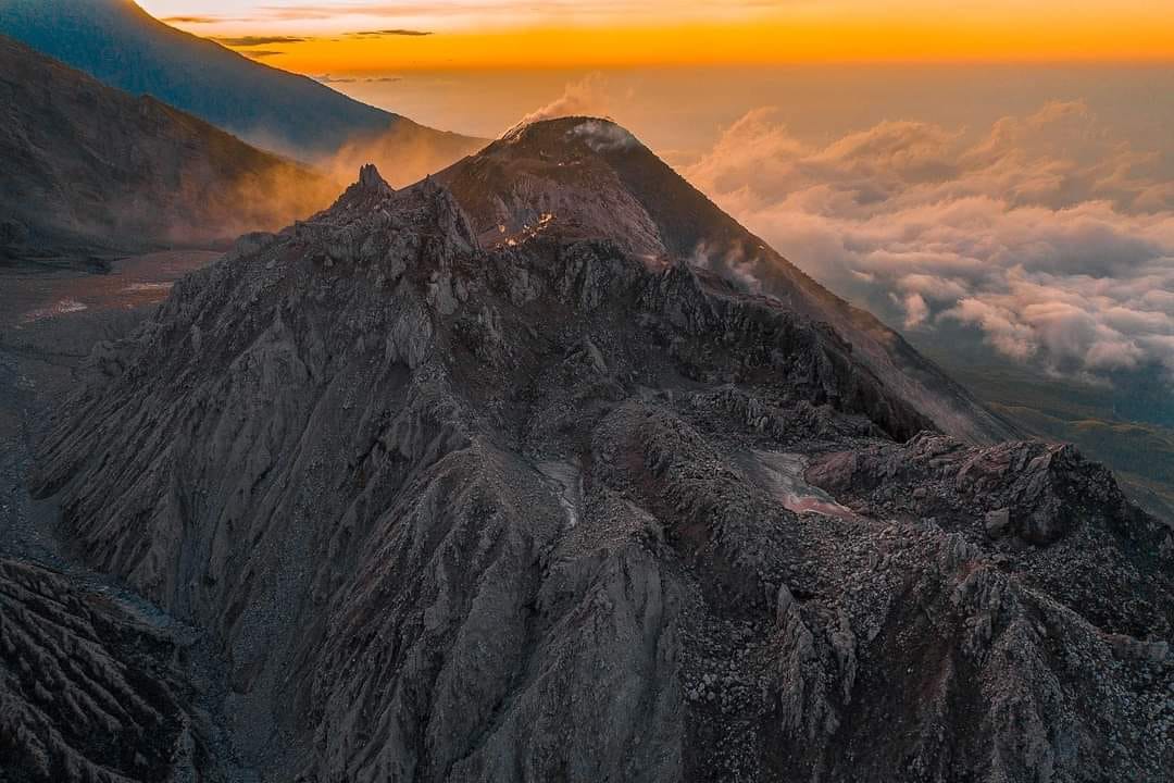
Remote Semisopochnoi volcano occupies the largest, young volcanic island in the western Aleutians. The uninhabited island is part of the Alaska Maritime National Wildlife Refuge. It is located 65 km (40 mi) northeast of Amchitka Island and 200 km (130 mi) west of Adak, Alaska. Semisopochnoi volcano is dominated by an 8-km (5-mile) diameter caldera that contains a small lake and several post-caldera cones and craters. The age of the caldera is not known with certainty but is likely early Holocene. The north cone of Mount Cerberus, in the southwest part of the caldera, is the site of the current eruption, which began in 2018. The last known eruption prior to 2018 was in 1987 from Sugarloaf Peak on the south coast of the island.
Source : AVO.
Photos : AVO , Lerner, Allan .
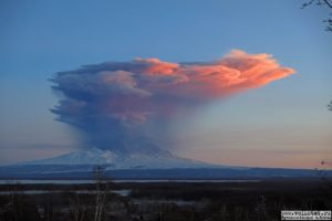
Peru , Sabancaya :
Analysis period: from October 31, 2022 to November 07, 2022, Arequipa, November 07, 2022.
Alert level: ORANGE
The Geophysical Institute of Peru (IGP) reports that the eruptive activity of the Sabancaya volcano remains at moderate levels, that is to say with the recording of an average of 30 daily explosions, with columns of ash and gas up to 3.0 km altitude above the summit of the volcano and their consequent dispersion. Therefore, for the following days, no significant change is expected in eruptive activity.
The IGP recorded and analyzed the occurrence of 305 earthquakes of volcanic origin, associated with the circulation of magmatic fluids inside the Sabancaya volcano. An average of 30 explosions was recorded daily, in addition to recording Volcano-Tectonic (VT) type events associated with rock fracturing inside the Sabancaya volcano.
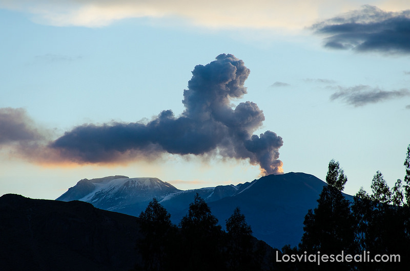
Monitoring the deformation of the volcanic structure using GNSS techniques (processed with fast orbits) does not show any significant anomalies. However, in general, an inflation process was observed in the northern sector (surroundings of the Hualca Hualca volcano). Visual surveillance identified columns of gas and ash up to 3.0 km a.s.l. above the volcano’s summit, which were dispersed to the eastern, southeast, and northeast sectors of Sabancaya. . Satellite recordings have identified the presence of 5 thermal anomalies, with a maximum value of 7 MW, associated with the presence of a lava body on the surface of the volcano’s crater.
RECOMMENDATIONS
• Keep the volcanic alert level orange.
• Do not approach within a radius of less than 12 km from the crater.
Source : Cenvul
Photo : Losviajesdeali.
Chile , Villarica :
Special Report on Volcanic Activity (REAV), De la Auracania region, Villarica volcano, November 07, 2022, 1:00 p.m. local time (mainland Chile).
The National Service of Geology and Mines of Chile (Sernageomin) publishes the following PRELIMINARY information, obtained through the monitoring equipment of the National Volcanic Monitoring Network (RNVV), processed and analyzed at the Volcanological Observatory of the Southern Andes ( Ovdas):
Monday, November 07, 2022, at 12:03 p.m. local time (15:03 UTC) and 12:09 p.m. local time (15:09 UTC), the monitoring stations installed near the Villarica volcano recorded 2 earthquakes associated with fluid dynamics (long period type), at the inside the volcanic system.
The characteristics of earthquakes after their analysis are as follows:
ORIGINAL TIME: 12:03 p.m. local time (15:03 UTC)
REDUCED DISPLACEMENT: 36.25 (cm*cm)
ACOUSTIC SIGNAL: 2.2 Pascals (Pa) reduced to 1 km
ORIGINAL TIME: 12:09 p.m. local time (15:09 UTC)
REDUCED DISPLACEMENT: 32.5 (cm*cm)
ACOUSTIC SIGNAL: 1.5 Pascals (Pa) reduced to 1 km
The characteristics of surface activity are as follows:
MAXIMUM HEIGHT OF THE COLUMN: 80 m above the point of emission
DIRECTION OF DISPERSION: Southeast (SE).
COMMENTS:
The images obtained by the IP cameras made it possible to observe the degassing without emissions of volcanic products associated with the reported events.
The volcanic technical alert remains at the Green level.
Sources : Sernageomin.
Photo : ameriquedusud.org.
Colombia , Cumbal Volcanic Complex :
Cumbal Volcanic Complex Weekly Activity Bulletin
The activity of the Cumbal Volcanic Complex continues at YELLOW LEVEL or (III): CHANGES IN THE BEHAVIOR OF VOLCANIC ACTIVITY.
From monitoring the activity of the CUMBAL VOLCANIC COMPLEX (CVC), the COLOMBIAN GEOLOGICAL SERVICE (SGC) reports that:
In the period from October 25 to 31, compared to the previous week, the activity presented a similar number of events with a slight decrease in the energy of the earthquakes.
Seismicity associated with rock fracture prevailed, located mainly near the Cumbal volcanic complex, at distances up to 2.3 km, with depths less than 2.5 km from the height of the crater from La Plazuela (4700 m above sea level) and with a maximum magnitude of 0.5.
It was possible to record white columns of gas emission, variable height and dispersion due to the direction of the winds, coming from the fumarolic field of El Verde (NE del CVC) and the fumarolic fields of Los Rastrojos , Boca Vieja and Las Bandas (SW of CVC).
No significant variation was observed in the other volcanic monitoring parameters.
The COLOMBIAN GEOLOGICAL SERVICE remains attentive to the evolution of the volcanic phenomenon and will continue to report the changes observed in a timely manner.
Source et photo : SGC.
Guatemala , Santiaguito :
Atmospheric conditions: Clear weather
Wind: North-East.
Precipitation: 8.2 mm.
Activity :
The Observatory of the Santa María-Santiaguito Volcanic Complex reports abundant fumaroles of degassing 700 meters above the Caliente dome, which move towards the South-East, South and South-West, as well as a constant incandescence from the dome during clear weather hours at night and early morning. Explosions accompanied by rumblings are sometimes recorded. Avalanches were also observed descending the western and southern flanks. The activity ahead of the active lava flow in the San Isidro and El Tambor channels continues with some boulder collapses, which generate ash clouds that can reach several hundred meters high, especially towards the « Zanjón Seco ».
It is recommended not to approach the lava flow, due to the intense heat it emits and the constant collapses that occur on its edges, which could cause burns and other serious injuries to those who come close. The extrusive activity remains at a high level and continues to accumulate material in an unstable way in the lava flow, as well as in the cupola of the Caliente dome, so it remains possible that part of this material collapses and generates pyroclastic flows over long distances to the South-West, South and East.
Source : Insivumeh.
Photos : Noticias Caballo Blanco