September 02 , 2021.
Nicaragua , Telica :
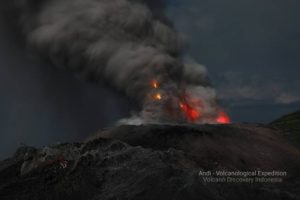
The Nicaraguan Telica volcano records eruptive activity, without victims.
The Telica volcano, located in northwest Nicaragua, recorded eruptive activity on Wednesday and at the same time as a landslide that affected three neighboring communities, without causing any victims, reported the National Prevention System, d disaster mitigation and assistance (Sinapred).
The collapse inside the crater of the 1,061-meter-high Telica volcano occurred at 5:25 a.m. local time (11:25 GMT), after which eruptive activity occurred, according to official information.
According to Sinapred, the volcano’s explosions occurred when the volcano cleared debris caused by the landslide that blocked its crater.
Nicaraguan authorities calculated that the column of ash rose about 250 meters above the crater of the Telica volcano.
The ash and volcanic material fell mainly in the communities of Aguas Frías, Las Marías and San Pedro Nueva, but there was no human effect, according to information published by Sinapred, and by Nicaraguan government media.
The eruptive activity did not show any alterations in the « real-time seismic amplitude » (RSAM) data, with which authorities did not expect a major eruption to be imminent.
The Telica is located 112 km northwest of Managua and is one of the most active volcanoes in Nicaragua.
Last December, Telica recorded 775 explosions in the space of four days, with a column of gas rising 457 meters above the crater. Only two months before, he had recorded a similar event, which had lifted volcanic material up to 1,000 meters in height.
Source : pulsoslp.com.mx.
Photo : Enfoque Noticias
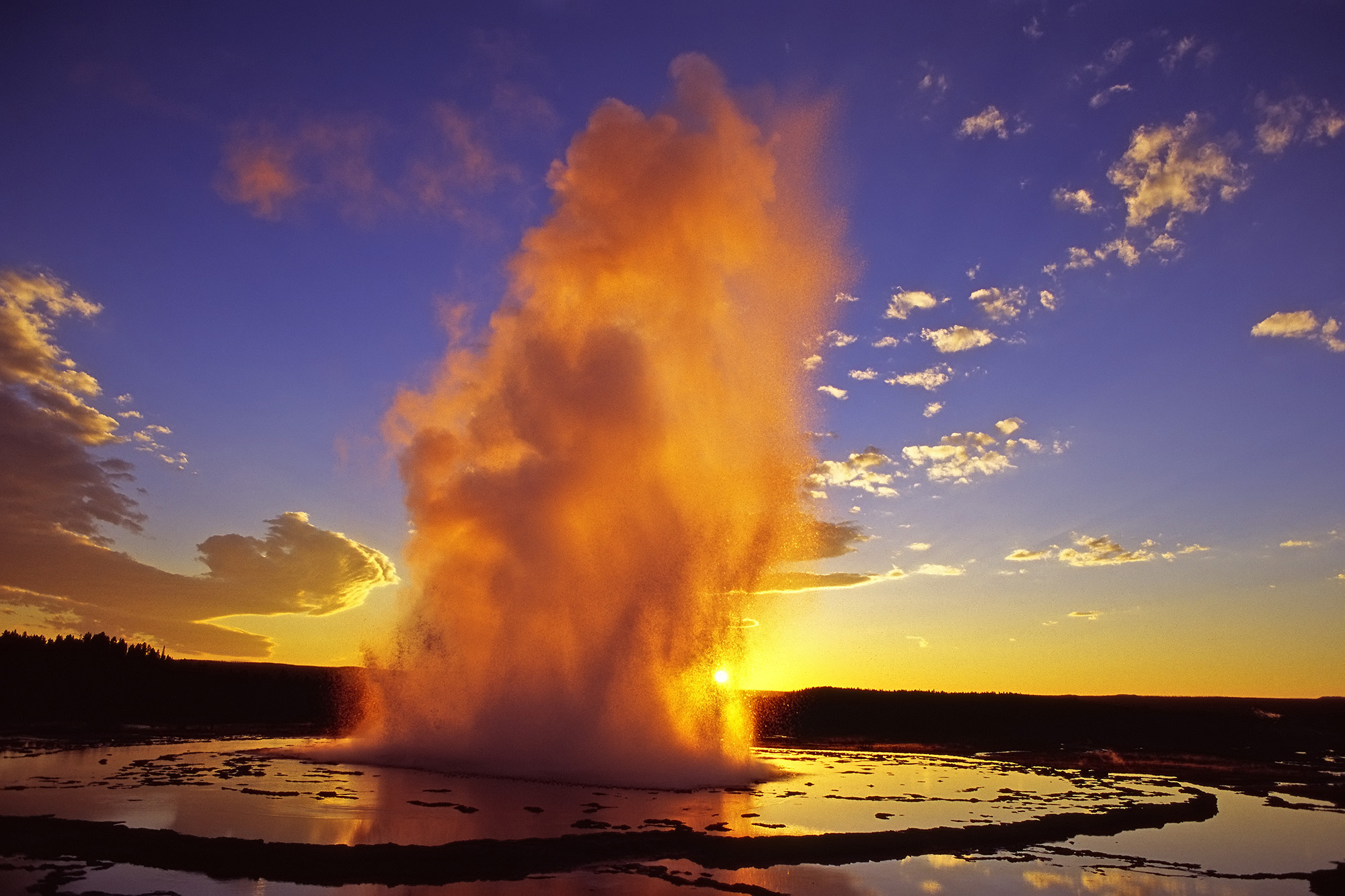
United – States , Yellowstone :
44°25’48 » N 110°40’12 » W,
Summit Elevation 9203 ft (2805 m)
Current Volcano Alert Level: NORMAL
Current Aviation Color Code: GREEN
Recent work and news
August is a busy season for visitors in Yellowstone, but most geologic work during the month happened in the lab and office, with Yellowstone Volcano Observatory scientists analyzing data collected during the first few months of the summer. One exception was work on Yellowstone Lake, where geologists collected core samples from the lake bottom that will help better identify and understand past hydrothermal explosions, the deposits of which are preserved as distinct layers in the sediments that make up the lake floor.

Steamboat Geyser did not erupt during the month of August, and the total number of eruptions for the year remains 13. The time between major Steamboat water eruptions is lengthening, which probably indicates that the geyser is entering a period of quiescence. This is typical behavior for Steamboat, with the geyser experiencing few-year periods of frequent eruptions separated by years to decades of very few eruptions. The most recent eruption of Steamboat Geyser was on July 8. In mid-late August, a sequence of minor eruptions started at the geyser, and these usually precede major water eruptions, so the show is probably not quite over yet.
Seismicity
During August 2021, the University of Utah Seismograph Stations, responsible for the operation and analysis of the Yellowstone Seismic Network, located 97 earthquakes in the Yellowstone National Park region—a sharp decrease after more than 1000 events were located during the month of July. The largest event of the past month was a minor earthquake of magnitude 3.1 located 12 miles northeast of West Yellowstone, MT, on August 20 at 11:00 AM MDT.
Although there was some minor ongoing seismicity that continued from July’s energetic swarm beneath Yellowstone Lake, no swarm activity was observed in August.
Yellowstone earthquake activity returned to background levels.
Ground deformation
Subsidence of Yellowstone Caldera, which has been ongoing since 2015, has paused during the summer months, reflecting seasonal groundwater recharge. Every summer, water from snow melt causes the ground to swell slightly, resulting in a pause in subsidence trends or even a minor amount of uplift (less than 1 cm / fraction of an inch). In the area of Norris Geyser Basin, no significant uplift or subsidence has been detected by a nearby GPS station since the start of 2020.
Source : YVO.
Photos : USGS ( Daisy Geyser ) , USGS.
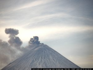
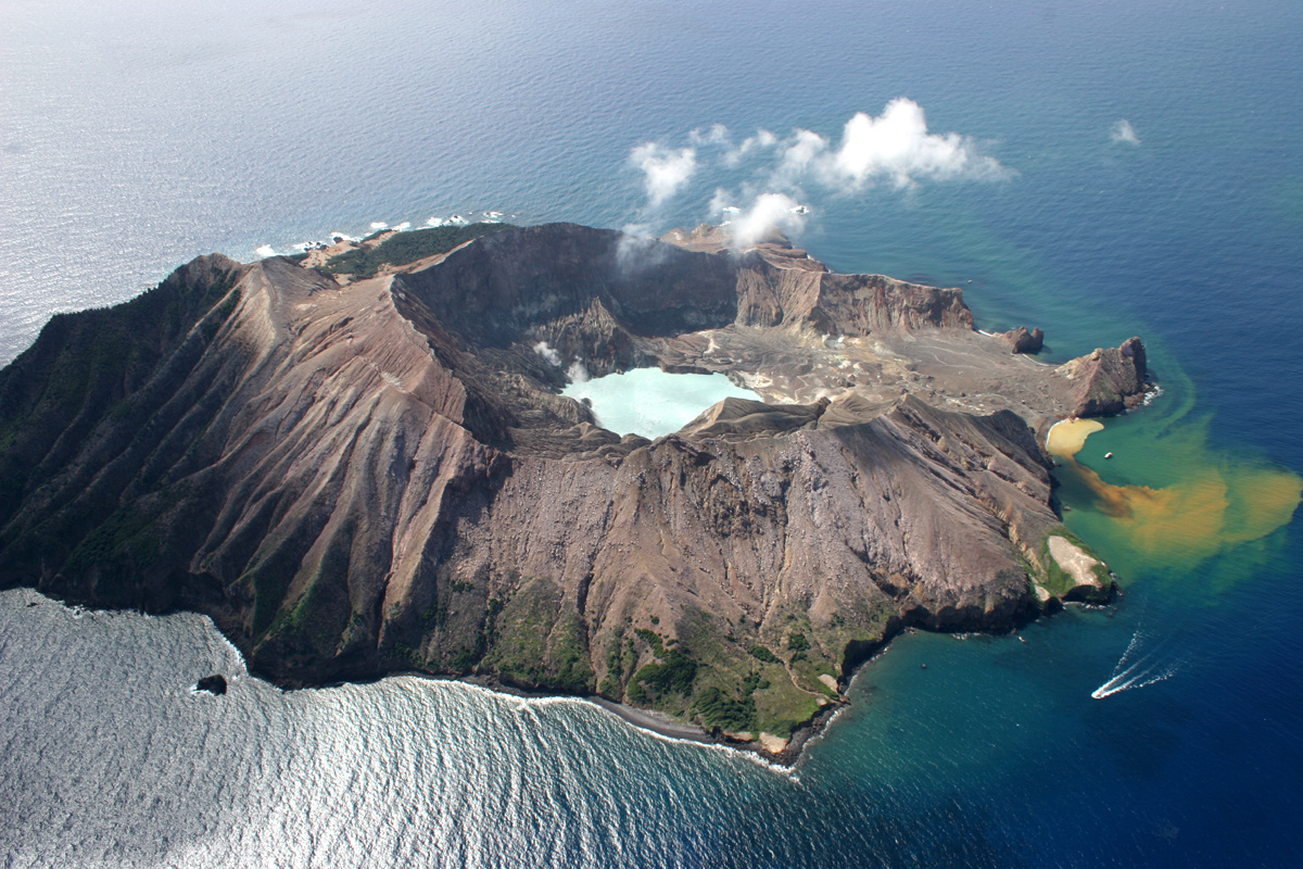
New Zealand , White Island :
Minor-weak ash emission has been occurring at Whakaari/White Island since early this morning. The Volcanic Alert Level remains at 2.
Since 6:50 AM this morning, minor ash emission has been observed from the active vent area at Whakaari/White Island by the web camera. It has not been clearly visible in camera images from Whakatane, until recently when images became hazy. Satellite images indicate a weak ash plume has now reached the area above the Bay of Plenty Coast. Any impact on the ground is unlikely, but traces of ash could be detected on surfaces.
This weak ashing phase is a continuation of the short episodes observed over the past few weeks at Whakaari. Today’s is more sustained through time, and due to the northerly wind direction, traces of ash are being transported toward the Bay of Plenty.

The seismic activity at the volcano has been minor with low level of tremor. There is no relationship between the ash emission and the seismic activity.
Webcam images continue to show night glow, suggesting that temperatures in the active vent area probably remain around 500-600°C, consistent with recent observations.
Satellite images from MetService show the volcanic ash going toward the Bay of Plenty coast and reaching the area above it at 1 PM. This ash plume is unlikely to create any ashfall on the ground.
Equipment that provides real-time monitoring on the island is currently degraded and we are continuing to work on restoration options.
The current level of activity is consistent with moderate levels of unrest. As such the Volcanic Alert Level remains at 2 and the Aviation Colour Code remains at Yellow.
The Volcanic Alert Level reflects the current level of volcanic unrest or activity and is not a forecast of future activity. While Volcanic Alert Level 2 is mostly associated with volcanic unrest hazards (including discharge of steam and hot volcanic gases, earthquakes, landslides and hydrothermal activity), potential for eruption hazards also exists and eruptions can still occur with little or no warning.
GNS Science and the National Geohazards Monitoring Centre continue to monitor Whakaari/White Island for further changes in unrest.
Source : Geonet / Agnès Mazot / Duty Volcanologist
Photos : Geonet . R. Fleming.
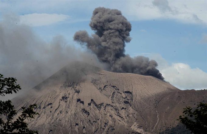
Indonesia , Semeru :
VOLCANO OBSERVATORY NOTICE FOR AVIATION – VONA.
Issued : September 01 , 2021
Volcano : Semeru (263300)
Current Aviation Colour Code : ORANGE
Previous Aviation Colour Code : orange
Source : Semeru Volcano Observatory
Notice Number : 2021SMR51
Volcano Location : S 08 deg 06 min 29 sec E 112 deg 55 min 12 sec
Area : East java, Indonesia
Summit Elevation : 11763 FT (3676 M)
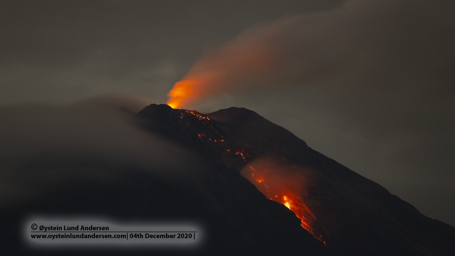
Volcanic Activity Summary :
Eruption with volcanic ash cloud at 22h44 UTC (05h44 local)
Volcanic Cloud Height :
Best estimate of ash-cloud top is around 12403 FT (3876 M) above sea level, may be higher than what can be observed clearly. Source of height data: ground observer.
Other Volcanic Cloud Information :
Ash-cloud moving to southwest
PVMBG reported that at 0718 on 26 August an ash plume from Semeru rose 500 m above the summit and drifted SW. The Alert Level remained at 2 (on a scale of 1-4), with a general exclusion zone of 1 km and extensions to 5 km in the SSE sector.
Source : Magma Indonésie , GVP.
Photo : Oystein lund Andersen .
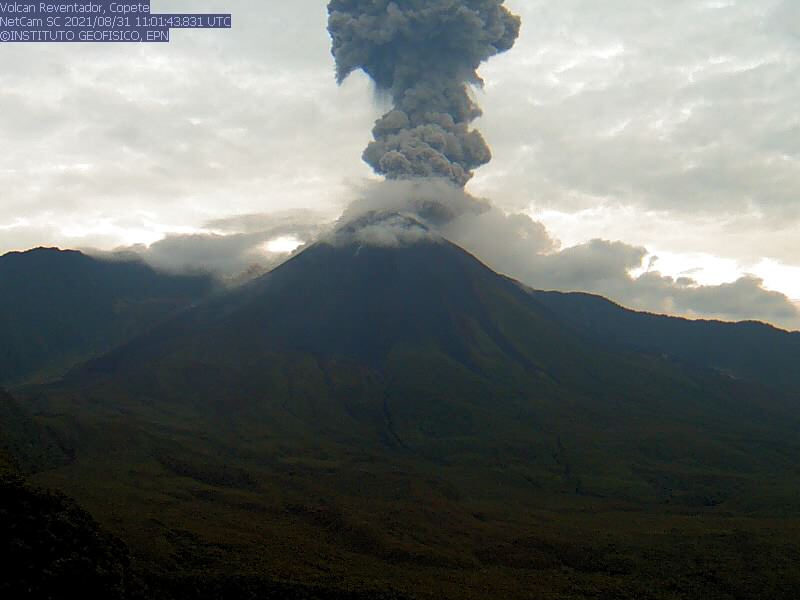
Ecuador , Reventador :
DAILY REPORT OF THE STATE OF THE REVENTADOR VOLCANO, Wednesday September 01, 2021.
Information Geophysical Institute – EPN.
Surface activity level: High, Surface trend: No change.
Internal activity level: Moderate, Internal trend: No change.
Seismicity: From August 31, 2021, 11: 00h to September 01, 2021, 11: 00h:
Explosions (EXP): 79 events
Long period type events (LP): 78
Tremors of emissions (TREMI): 16
Harmonic Tremors (TRARM): 7.
Rains / lahars: Rains were recorded in the area which did not generate lahars.
Emission / ash column: Today in the morning several gas and ash emissions were observed with altitudes between 100 and 1200 meters above the level of the crater and in a north-west direction. The Washington VAAC reported 2 alerts of emissions observed by satellites, their direction was maintained in the Northwest and the heights did not exceed 1000 meters above the level of the crater.
Other monitoring parameters: MIROVA has recorded 1 moderate thermal alert on the Reventador in the last 24 hours.
Observations: Incandescence was occasionally observed last night. Today, the volcano remained clear for most of the morning, making it possible to observe the emissions described above.
Alert level: Orange.
Source et photo : IG-EPN.
Guatemala , Fuego :
DESCENT OF LAHAR in the CENIZA ravine.
The heavy rainfall that persists on the Fuego volcano is currently generating a moderate lahar descent into the Ceniza ravine, a tributary of the Achiguate river, on the southern flank of the volcano. This lahar carries a pasty mixture of water, boulders up to 2 meters in diameter and finer sediment, as well as tree trunks and branches.
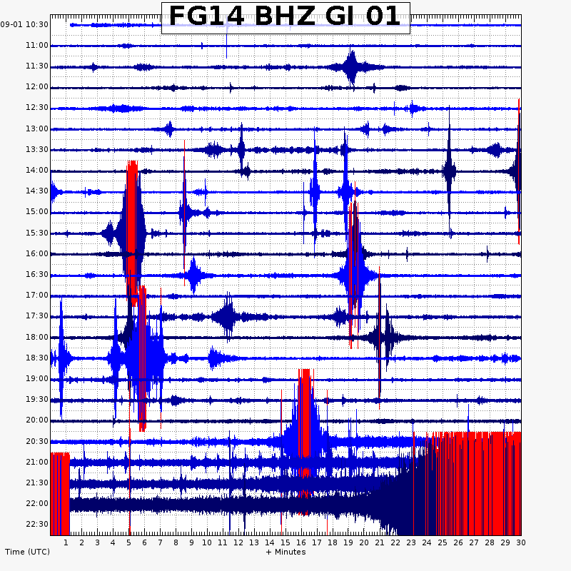
The lahars during their passage produce vibrations in the ground which are recorded in the seismic stations close to the ravines, in this case the FG14 station and the attached seismogram. If these rainy conditions persist in the region, it is not excluded that this lahar will increase in intensity in the coming minutes. There is the possibility that other lahars descend into one of the ravines of this volcano.
INSIVUMEH maintains visual and instrumental monitoring of volcanic activity through seismic stations, volcanoes observers and the web camera.
Source et photo : Insivumeh .