February 14 , 2022 .
Philippines , Taal :
TAAL VOLCANO BULLETIN 14 February 2022 8:00 AM
In the past 24-hour period, the Taal Volcano Network recorded thirty-three (33) volcanic earthquakes, including twenty-four (24) volcanic tremor events having durations of two (2) to five (5) minutes, seven (7) low-frequency volcanic earthquakes, one (1) hybrid event, and low-level background tremor that has persisted since July 7, 2021. Activity at the Main Crater was dominated by upwelling of hot volcanic fluids in its lake which generated plumes 1500 meters tall that drifted southwest. Sulfur dioxide (SO2) emission averaged 10,270 tonnes/day on 12 February 2022. Based on ground deformation parameters from electronic tilt, continuous GPS, and InSAR monitoring, Taal Volcano Island and the Taal region has begun deflating in October 2021.
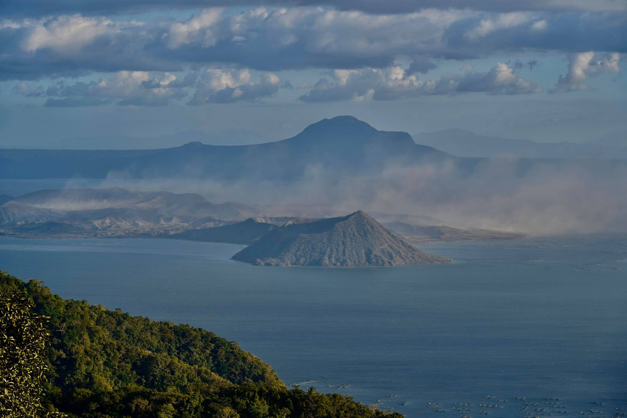
Alert Level 2 (Increased Unrest) prevails over Taal Volcano. DOST-PHIVOLCS reminds the public that at Alert Level 2, sudden steam- or gas-driven explosions, volcanic earthquakes, minor ashfall, and lethal accumulations or expulsions of volcanic gas can occur and threaten areas within and around TVI. DOST-PHIVOLCS strongly recommends that entry into Taal Volcano Island, Taal’s Permanent Danger Zone or PDZ must be strictly prohibited, especially the vicinities of the Main Crater and the Daang Kastila fissure, and extended stays on Taal Lake.
Source : Phivolcs.
Photo : Raffy Tima
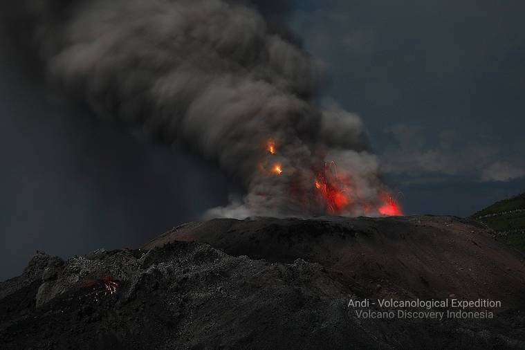
Indonesia , Ibu :
VOLCANO OBSERVATORY NOTICE FOR AVIATION – VONA
Issued : February 14 , 2022.
Volcano : Ibu (268030)
Current Aviation Colour Code : ORANGE
Previous Aviation Colour Code : unassigned
Source : Ibu Volcano Observatory
Notice Number : 2022IBU01
Volcano Location : N 01 deg 29 min 17 sec E 127 deg 37 min 48 sec
Area : North Maluku, Indonesia
Summit Elevation : 4240 FT (1325 M)
Volcanic Activity Summary :
Eruption with volcanic ash cloud at 01h40 UTC (10h40 local).
Volcanic Cloud Height :
Best estimate of ash-cloud top is around 7440 FT (2325 M) above sea level, may be higher than what can be observed clearly. Source of height data: ground observer.
Other Volcanic Cloud Information :
Ash-cloud moving to west
Remarks :
Eruption and ash emission is continuing.
Seismicity related to eruptions, avalanches, smoke emissions from the crater and magma activity. It was recorded:
– 58 earthquakes of eruptions/explosions
– 39 avalanche earthquakes
– 30 emission earthquakes
– 18 shallow volcanic earthquakes.
Source : Magma Indonésie , PVMBG.
Photo : Andi Rosati / Volcanodiscovery.
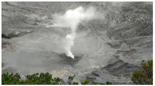
Indonesia , Tangkuban Parahu :
Assessment of the activity level of Mount Tangkuban Parahu, West Java based on visual and instrumental observational data for the period from January 30, 2022 to February 13, 2022 as follows:
I. Visual observation
According to the results of visual observations for the period from January 30, 2022 to February 13, 2022, the smoke from the Ratu crater is white with low to medium intensity, generally not observed at altitude. On February 12, 2022, since 11:43 a.m. WIB, white smoke was observed from the Ecoma crater with low to strong intensity with a height of up to 100 meters above the crater floor, while on February 13, 2022, white smoke was observed. was observed with low to medium intensity and rising 20-60 meters above the crater floor.
II. Instrumental observation
The seismicity of Mount Tangkuban Parahu is dominated by gusts associated with surface activity. Seismographs also record continuous vibrations caused by gas and wind gusts. The estimated seismic energy based on real-time seismic amplitude measurements (RSAM) shows fluctuations but no significant increase has been observed. Based on the estimate of the seismic coherence value of the RTU station, February 2022 showed a decrease in the coherence value due to increased pressure on the G. Tangkuban Parahu massif. This causes changes in the medium such as the formation of fractures so that smoke escapes into the Ecoma crater. This pattern was also observed before the July 2019 eruption, when it was accompanied by a significant increase in volcanic seismicity, but in February 2022, no increase in seismicity was observed. Seismic monitoring data indicates that there is no significant magmatic intrusion, the increase that occurs is still transient (temporary).
The results of strain measurement using the Electronic Distance Measurement (EDM) method show a relatively shortened (deflation) pattern. The results of the deformation measurements using the tiltmeter method fluctuate but are relatively flat, indicating that there has been no significant change in activity. Deformation monitoring data indicates that there is no significant pressure buildup.

The results of temperature measurements on the slopes of Kawah Ratu increased on February 12, 2022 and the results of temperature measurements on February 13, 2022, decreased again. The temperature increase that occurred on February 12, 2022 is still transient (temporary).
The CO2 gas concentration measurement results are relatively stable, while the H2S gas concentration is relatively reduced. The C/S gas ratio on February 12, 2022 has increased. The results of measurements of H2S gas concentrations on February 13, 2022 began to show an increase and the C/S gas ratio decreased compared to the C/S gas ratio on February 12, 2022. Geochemical monitoring data showed an ( temporary) increase in temperature in the underground system of Mount Tangkuban Parahu, but the increase is not continuous. This indicates that the contribution of magmatic fluid in this activity is not yet significant.
III. Evaluation
Visual and instrumental observations indicate that the volcanic activity of Mount Tangkuban Parahu has not experienced a significant increase. The emission that occurred in the Ecoma crater is thought to be due to the dynamics of groundwater or water that seeps below the surface, which is then heated and forms a high vapor buildup. pressure, resulting in a temporary overpressure of the gas exiting in the form of a rather strong burst through the weak zone (fracture). The white emission indicates that this activity is dominated by water vapour.
Referring to the results of visual and instrumental monitoring and the estimation of the latest potential threats, the activity level of Mount Tangkuban Parahu is still at level I (normal).
Source : PVMBG.
Photos : PVMBG , MNC Trijaya ( 2019)
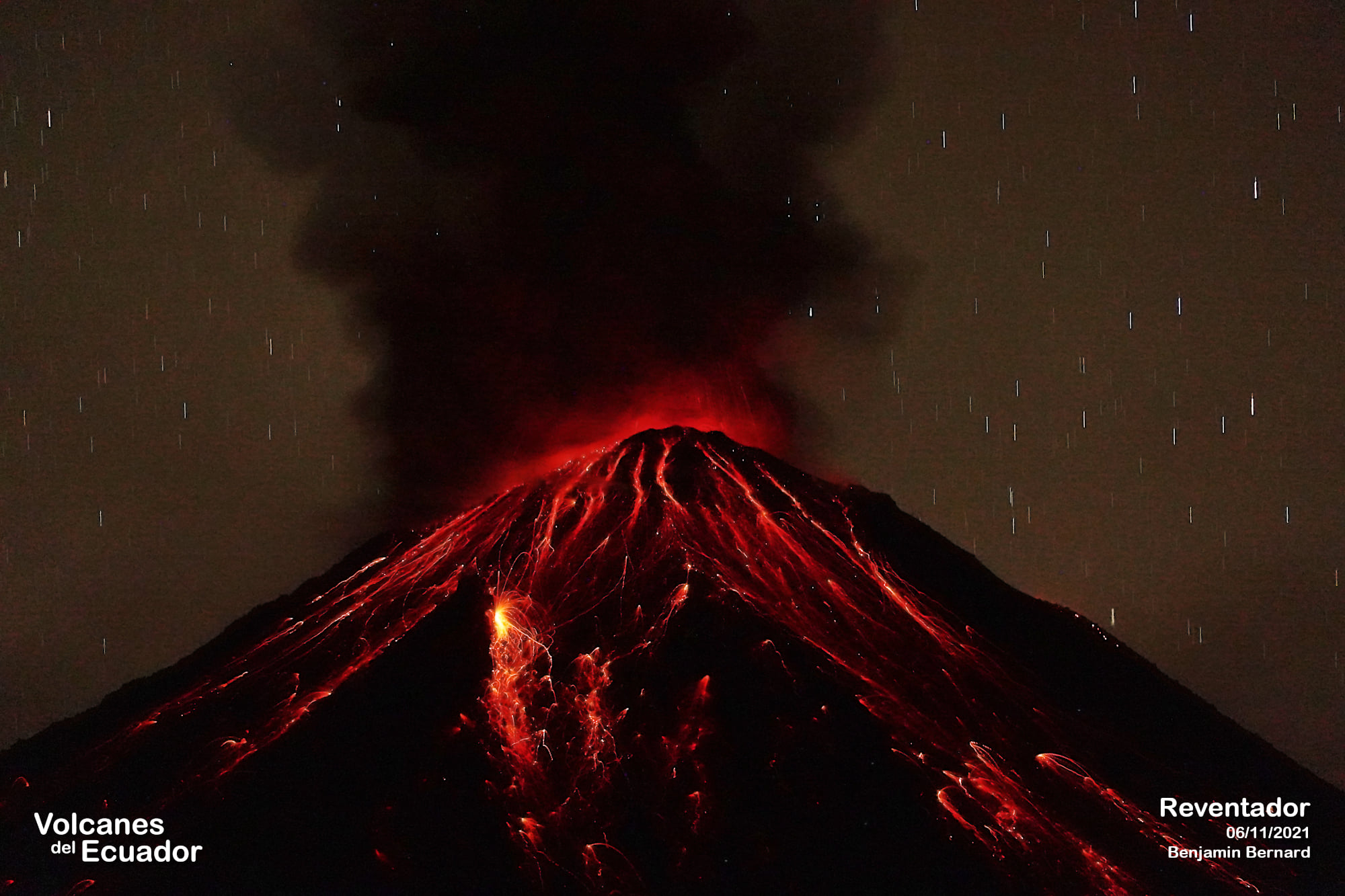
Ecuador , Reventador :
DAILY REPORT OF THE STATE OF THE REVENTADOR VOLCANO, Thursday February 13, 2022.
Information Geophysical Institute – EPN.
Surface Activity Level: High, Surface Trend: No change.
Internal activity level: Moderate, Internal trend: No change.
Seismicity: From February 12, 2022, 11:00 a.m. to February 13, 2022, 11:00 a.m.:
Explosion (EXP) 20
Long Periods (LP) 53
Emission Tremors (TREMI) 6.
Harmonic tremor (TRARM): 2
Rains / Lahars:
No rain was recorded
Emission / ash column:
Yesterday afternoon, steam and ash emissions were observed with a maximum height of 500 meters above crater level and heading west. The Washington VAAC issued 1 ash emission alert with a maximum height of 988 meters above crater level heading west.
Other Monitoring Parameters:
In the past 24 hours, there are no thermal alert records for the Reventador.
Observation:
The volcano was cloudy most of the time. However, during the night, an incandescence was observed between the clouds at the level of the crater. It’s still cloudy at the moment.
Alert level: Orange.
Source : IGEPN.
Photo : Benjamin Bernard.
Japan , Hakoneyama :
Visitors to the scenic resort town of Hakone in Kanagawa Prefecture will soon be allowed to walk along a nature trail in the Owakudani Valley for the first time since minor volcanic eruptions seven years ago.
The trail was closed after the Volcanic Alert Level for Mount Hakone was raised to 2 on a scale of 1-5 in May 2015. The level was later lowered to 1, but the path remained off-limits. security reasons.
A council including prefecture and city officials decided to reopen the path after near-urgent coronavirus restrictions were lifted.
Members say sufficient measures to keep visitors safe are now in place. Stages include new shelters and additional volcanic gas detection devices.
They also say that tour groups will be accompanied by security guides. Group sizes and tour durations will be limited.

Hakoneyama volcano is truncated by two overlapping calderas, the largest of which is 10 x 11 km wide. The calderas were formed as a result of two major explosive eruptions about 180,000 and 49,000-60,000 years ago. Scenic Lake Ashi lies between the SW caldera wall and a half dozen post-caldera lava domes that were constructed along a NW-SE trend cutting through the center of the calderas. Dome growth occurred progressively to the NW, and the largest and youngest of these, Kamiyama, forms the high point. The calderas are breached to the east by the Hayakawa canyon. A phreatic explosion about 3000 years ago was followed by collapse of the NW side of Kamiyama, damming the Hayakawa valley and creating Lake Ashi. The latest magmatic eruptive activity about 2900 years ago produced a pyroclastic flow and a lava dome in the explosion crater, although phreatic eruptions took place as recently as the 12-13th centuries CE. Seismic swarms have occurred during the 20th century. Lake Ashi, along with the thermal areas in the caldera, is a popular resort destination SW of Tokyo.
Sources : 3.nhk.or.jp , GVP .
Photo : GVP