April 4 , 2024
La Réunion , Piton de la Fournaise :
Monthly newsletter. Paris Institute of Globe Physics / Piton de la Fournaise Volcanological Observatory.
Activity of Piton de la Fournaise
Seismicity:
In March 2024, the OVPF-IPGP recorded a total of:
• 179 superficial volcano-tectonic earthquakes (0 to 2.5 km above sea level) under the summit craters;
• 1 deep earthquake (below sea level);
• 24 long-period earthquakes;
• 184 landslides.
The month of March 2024 will have been marked by an increase in seismicity under the summit from March 5, going from 1 superficial volcano-tectonic earthquake per day at the start of the month to 4 to 5 per day in the middle of the month, before falling again. at 1 per day at the end of the month.
Most of these earthquakes, of low magnitude (<1), cannot be localized, but 17 could be located under the Dolomieu crater between -500 and 1200 m above sea level.
Numerous (184) landslides in the Dolomieu Crater, at the Cassé de la Rivière de l’Est and at the level of recent lava flows were also recorded.
Deformation
Peak inflation which stopped at the end of November 2023 resumed in February 2024. This slow inflation (the maximum elongation of the base of the terminal cone was approximately 2.5 cm in 1 month) is linked to a pressurization of the superficial magmatic reservoir located at a depth of 1.5-2 km under the craters. .
Balance sheet
The increase in seismicity in March 2024 follows a resumption of inflation of the volcanic edifice since the second half of February 2024. This inflation – whose source is centered under the summit – is linked to the pressurization of the reservoir superficial, located at approximately 1.5-2 km depth under the Dolomieu crater.
The appearance of seismicity at the roof of the reservoir shows that this pressurization process is intensifying, even if the number of earthquakes decreased at the end of the month and the associated magnitudes remain moderate.
Note that this process of pressurization of the surface reservoir can last several days to several weeks before the roof of the reservoir weakens and ruptures, thus giving rise to an injection of magma towards the surface and an eruption, but can also stop without giving rise – in the short term – to an eruption.
Source et photo : OVPF
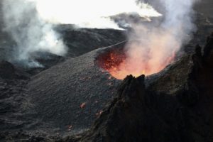
Iceland , Reykjanes Peninsula :
IMO reported that an average lava effusion rate from vents along the fissure within the Reykanes volcanic system was estimated to be 7.8 (plus or minus 0.7) cubic meters per second during 20-27 March, based on a 27 March satellite image. The lava-flow field was about 5.99 square kilometers with an approximate volume of 25.7 (plus or minus 1.9) million cubic meters. Lava flows continued to advance S over older flows emplaced during the beginning of the eruption. Satellite data from 26 March showed that the flow field was expanding to the W in the area S of Hagafell as well as in areas E and S of the active vents.
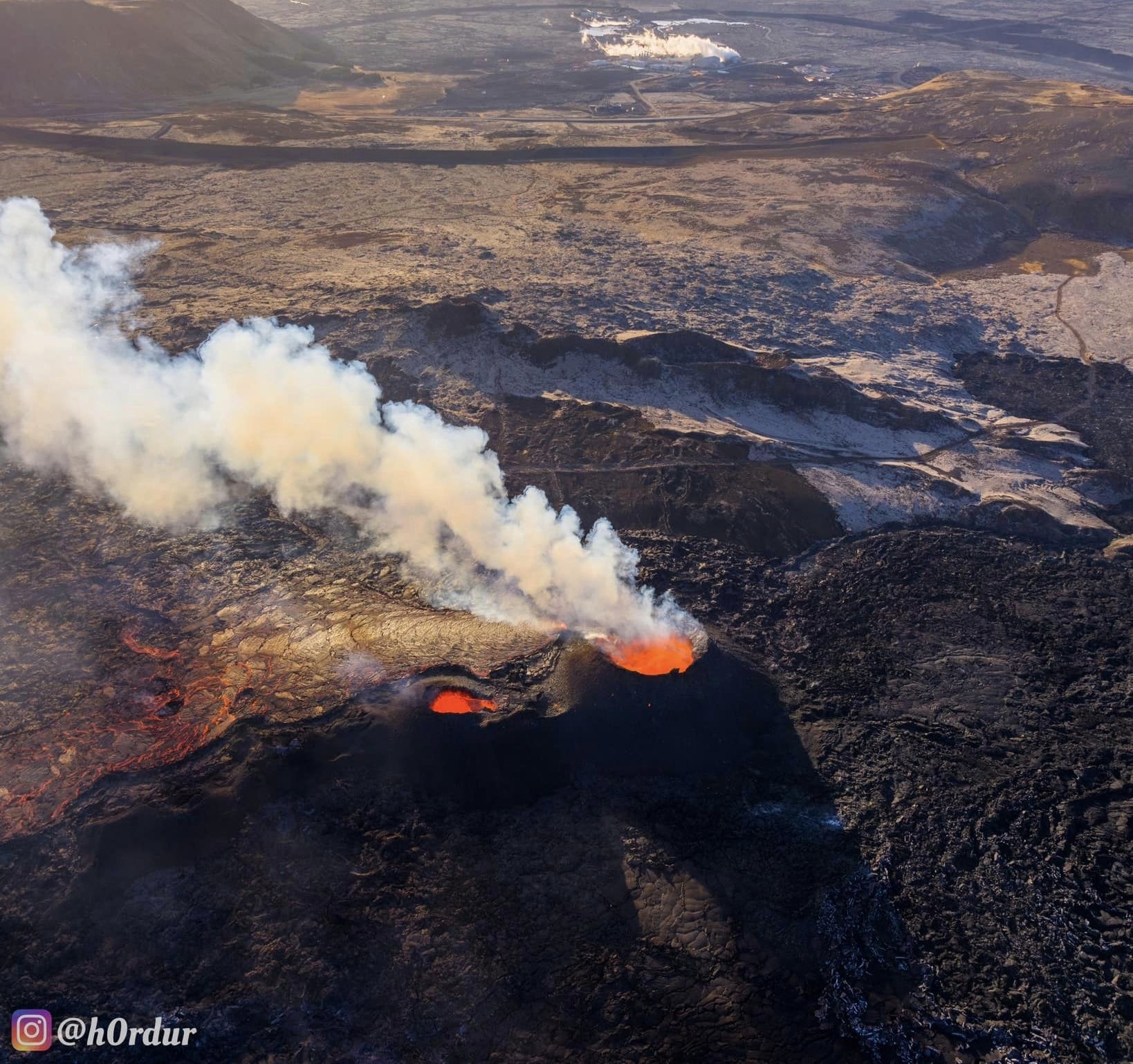
Almost no seismicity was detected. Lava continued to erupt from vents during 27 March-2 April, though by 31 March two of three vents were active and the cones continued to grow. Inflation ceased to be detected during the week. IMO warned that the margins of the lava flows were tall in some places and that sudden breakouts of lava or collapses of material were possible. Wildfires had been noted near the margins of the flow field. The Aviation Color Code remained at Orange (the second highest level on a four-color scale).
Sources: Icelandic Meteorological Office (IMO) , GVP.
Photo : Hörður Kristleifsson
Costa Rica , Poas :
OVSICORI-UNA reported increasing activity at Poás. During 22-25 March sulfur dioxide gas emissions were as high as 277 tons based on satellite data and characterized as significant. Parque Nacional Volcán Poás officials and residents to the W reported health impacts from the emissions including headaches, nausea, nose bleeding, and irritations of eyes, nose, mouth, and skin. On 25 March an infrared camera recorded a fumarolic vent temperature of 302 degrees Celsius and glowing pink-purple-blue flames were visible.
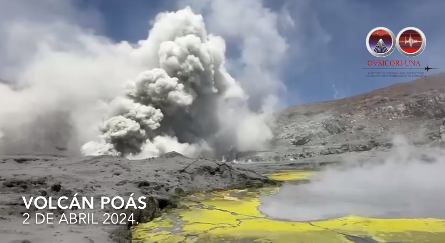
Vigorous emissions of gas, steam, and sediments from fumarolic vents on the nearly dry crater floor persisted during 25-28 March; activity intensified on 29 March and remained elevated through 2 April. Seismic and infrasound signals associated with the loud discharge of the emissions through the vent structures were near-continuous. During 27-30 March numerous small phreatic eruptive events from the central part of the crater floor ejected water and sediment that mostly fell back onto the crater floor. Sulfur odors were reported in areas downwind, including Sucre San Carlos (23 km WNW), Zarcero, Grecia (16 km SW), Sabana Redonda (9 km S), San Pedro de Poás (14 km S), Monte de la Cruz (22 km SE), San Rafael, and San Isidro de Heredia (28 km SE); health impacts continued to be noted. On 29 March a vent on the N part of the crater floor completely dried up and two explosive eruptive events were recorded that same day.
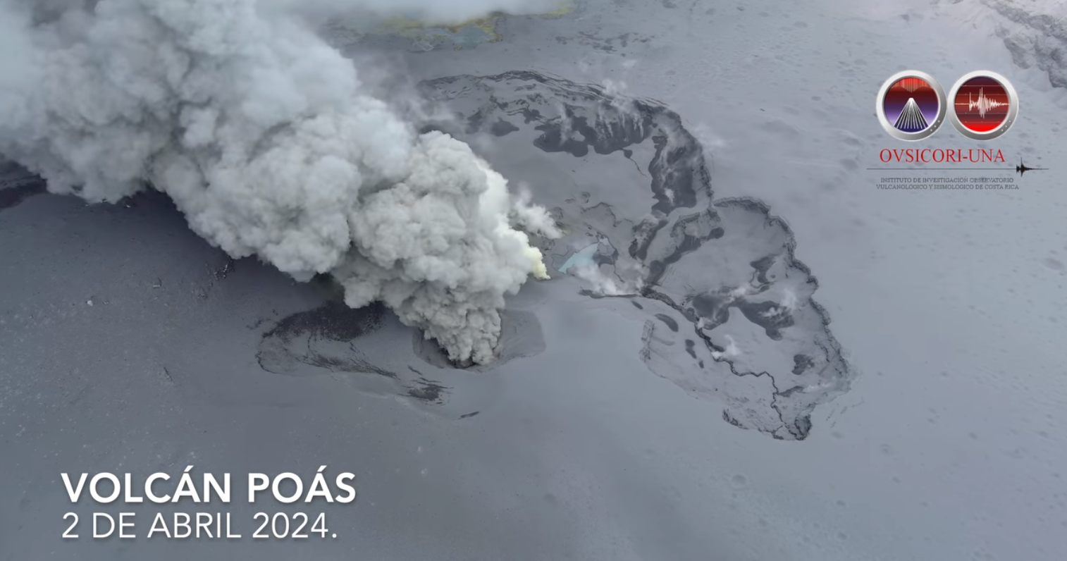
Ash was sporadically emitted from the vents during 29-30 March and fine ash fell in areas to the W including Sarchí (18 km SW), Grecia, Naranjo (17 km WSW), San Ramón de Alajuela (30 km WSW), Palmares (27 km SW), and Atenas. The ash content of the emissions increased on 31 March and sulfur odors were recorded in additional towns to the W, SW, and S, including Ron Ron, Sarchí, Tacares, Naranjo, Palmares, Tacares, Alajuela (20 km S), Guácima (27 km S), Garita (27 km SSW), San Ramón, and Tambor, Turrucares (28 km SSW), Atenas, Carrillo de Poás (19 km S), Santa Rosa de Poás (11 km S), Santa Bárbara (18 km SSE), and San Isidro. The emissions were not dense during 31 March-1 April and the plumes stayed low around the elevation of the volcano (2.4 km a.s.l.). On 1 April satellite data showed that 714 tons of sulfur dioxide gas was detected, representing a significant increase and the highest recorded value since a period of elevated activity during 2017-2019. Residents continued to report sulfur dioxide odors and minor ashfall during 1-2 April.
Sources: Observatorio Vulcanologico y Sismologico de Costa Rica-Universidad Nacional (OVSICORI-UNA) , GVP.
Photos : Capture d’écran Ovsicori
Japan , Kuchinoerabujima :
JMA reported that the number of shallow volcanic earthquakes at Kuchinoerabujima increased during June and July 2023, fluctuated at elevated levels, began to decrease in mid-January 2024, and continued to decrease through March. The epicenters were mainly located near Furudake Crater, with some located near Shindake Crater (just N of Furudake). Sulfur dioxide emissions shared a similar pattern with increases starting in July 2023, peaks of 200-400 tons per day (t/d) during August-September, and a gradual decrease to less than 100 t/d by 18 March 2024 . A geothermal area near Furudake Crater expanded and temperatures increased during October-December 2023 but beginning in January 2024 both the temperatures and the size decreased. No changes to the geothermal area near the fissure on the W side of Shindake Crater were observed during March. At 1400 on 27 March the Alert Level was lowered to 2 (on a scale of 1-5) with restrictions to access encompassing only the crater area. JMA noted that seismic activity continued to be recorded near the crater, and that the sulfur dioxide emissions and the level of activity at the geothermal areas remained at higher levels than before activity increased in June 2023.
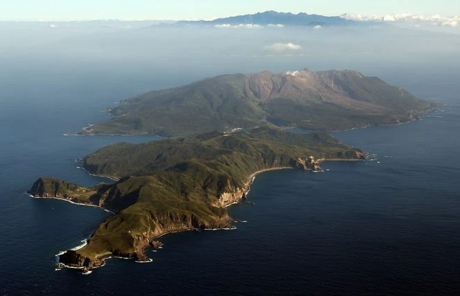
A group of young stratovolcanoes forms the eastern end of the irregularly shaped island of Kuchinoerabujima in the northern Ryukyu Islands, 15 km W of Yakushima. The Furudake, Shindake, and Noikeyama cones were erupted from south to north, respectively, forming a composite cone with multiple craters. All historical eruptions have occurred from Shindake, although a lava flow from the S flank of Furudake that reached the coast has a very fresh morphology. Frequent explosive eruptions have taken place from Shindake since 1840; the largest of these was in December 1933. Several villages on the 4 x 12 km island are located within a few kilometers of the active crater and have suffered damage from eruptions.
Source: Japan Meteorological Agency (JMA), GVP.
Photo : Asahi Shimbun
Colombia , Chiles / Cerro Negro :
Weekly Activity Bulletin: Chiles Volcanic Complex and Cerro Negro (CVCCN)
Regarding the monitoring of the activity of the CHILES AND CERRO NEGRO VOLCANOES, the MINISTRY OF MINES AND ENERGY, through the COLOMBIAN GEOLOGICAL SERVICE (SGC), reports that:
Between March 26 and April 1, 2024 and compared to the previous week, a decrease in the frequency of earthquakes and their energy released was recorded. The predominant seismicity continued to be linked to the fracture of rocks in the volcanic edifice, although the presence of earthquakes associated with the movement of fluids inside these volcanoes continued, some of them with very low frequency content.
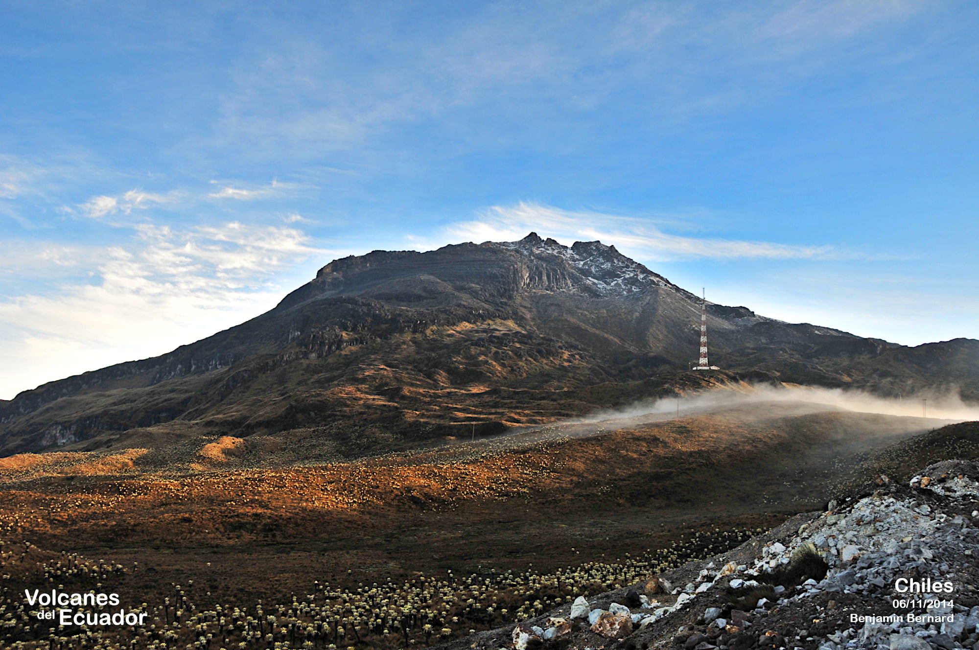
The fracture earthquakes were located in two groups: the first in the South-Southeast quadrant of the Chiles volcano, at distances less than 7 km, with depths between 2 and 9 km from its summit (4,700 m altitude) and a maximum magnitude of 1.5. The other group of earthquakes was located at the summit of Chiles Volcano, with depths less than 6 km from its summit (4,700 m above sea level) and magnitudes less than 1.3.
Volcanic deformation processes recorded by sensors installed on the ground and by remote satellite sensors continue. The evolution of activity in the CVCCN is the result of internal processes derived from the complex interaction between the magmatic system, the hydrothermal system and the geological faults of the area. Thus, the probability of the occurrence of energetic earthquakes that can be felt by residents of the CVCCN zone of influence continues.
Volcanic activity remains in a YELLOW ALERT state: Active volcano with changes in the behavior of the base level of monitored parameters and other manifestations.
Source : SGC.
Photo : Benjamin Bernard.