July 24 , 2021.
Indonesia , Merapi :
Report on the activity of Mount Merapi, July 16-22, 2021
OBSERVATION RESULTS
Visual
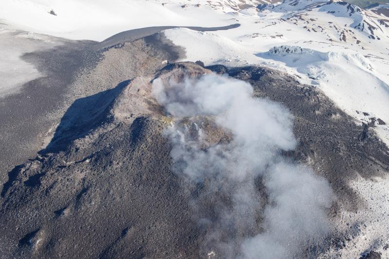
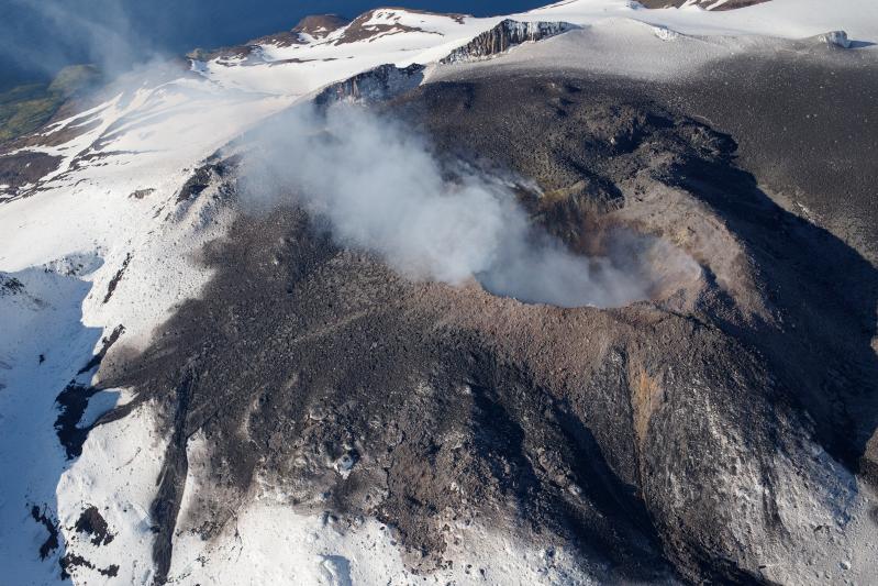
The weather around Mount Merapi is generally sunny in the morning and evening, while it is foggy in the afternoon. White, weak to thick, low pressure, 600m high smoke was observed from the Mount Merapi de Selo observation post on July 21, 2021 at 5:50 p.m. WIB.
This week, lava avalanches were observed 62 times southeast with a maximum slide distance of 1,200 m, 101 times southwest with a maximum slide distance of 1,800 m, 2 times toward the ‘West with a maximum sliding distance of 1,500 m, and once towards the North-West with a distance of 1,500 m. The avalanches observed on the west side are old lavas from 1992 and 1998, as well as the avalanches on the northwest side are old lavas from 1948.
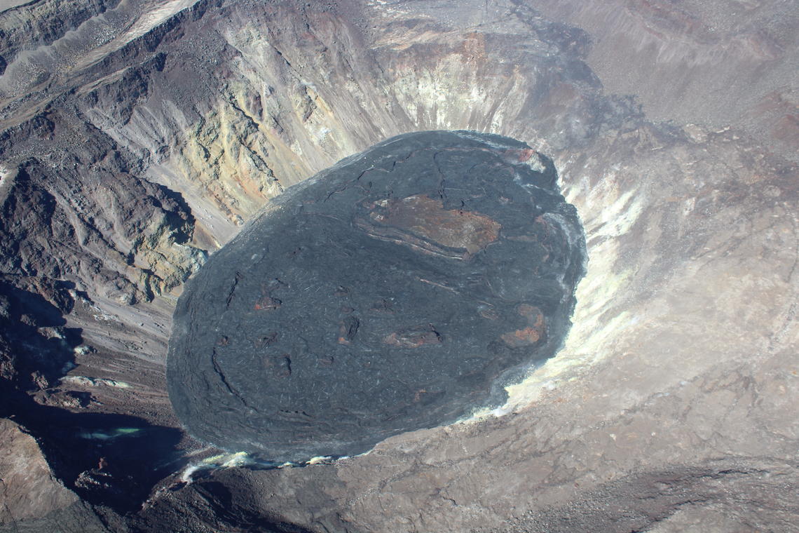
The morphological analysis of the camera of the Tunggularum Station shows a volume of the dome in the southwest sector of 1,880,000 m3, while the analysis of the camera of the Deles3 Station shows the volume of the central dome of 2 808,000 m.

Seismicity
This week, the seismicity of Mount Merapi showed:
273 shallow volcanic earthquakes (VTB),
7 low frequency earthquakes (LF),
1,067 multi-phase earthquakes (MP),
1,476 avalanche earthquakes (RF),
145 emission earthquakes (DG),
6 tectonic earthquakes (TT).
The intensity of this week’s seismicity is still quite high.
Deformation
The deformation of Mount Merapi, which was monitored using EDM this week, showed a distance shortening rate of 7cm / day.
Rain and lahars
This week, there have been no reports of rain, lahars or additional flow in the rivers that originate on Mount Merapi.
Conclusion
Based on the results of visual and instrumental observations, it is concluded that:
The volcanic activity of Mount Merapi is still quite high in the form of effusive eruption activity. The status of the activity is defined in the “SIAGA” level.
Source : BPPTKG.
Photo : Andi Volcano .
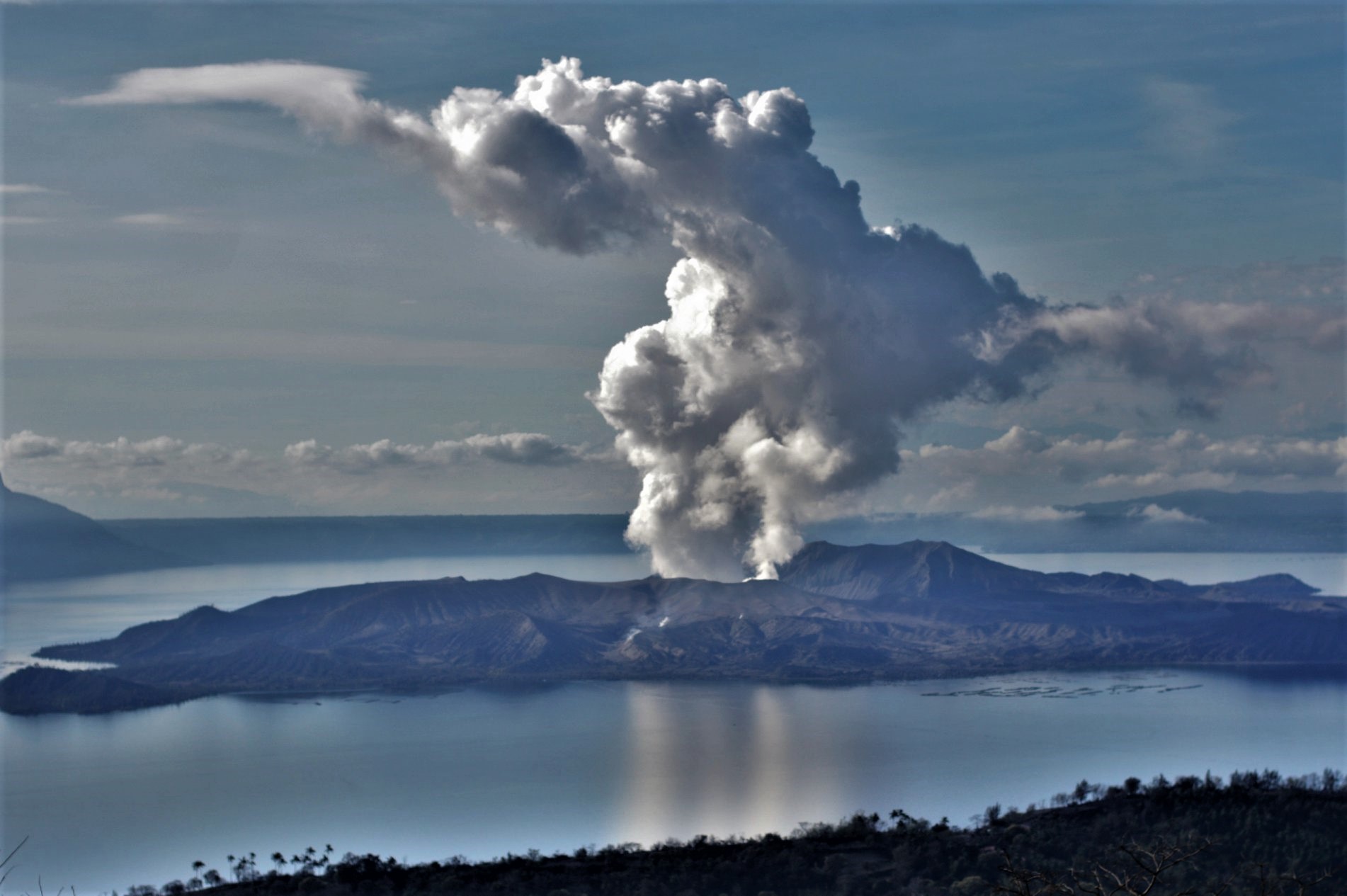
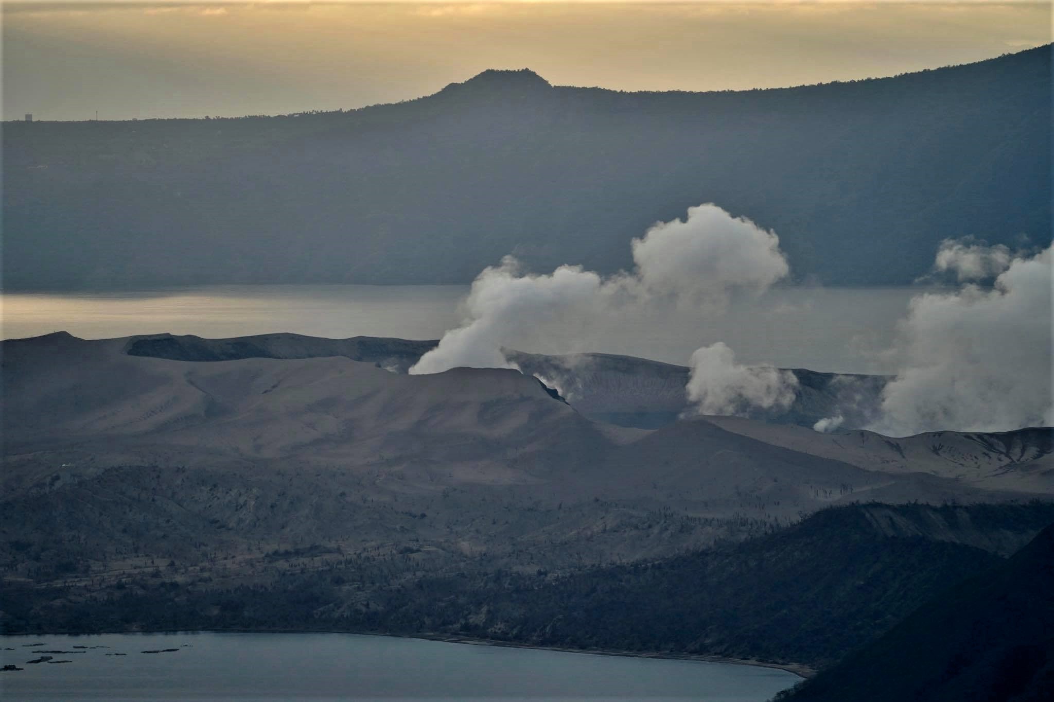
Philippines , Taal :
TAAL VOLCANO BULLETIN 23 July 2021 07:30 PM
This serves as a notice for the lowering of Taal Volcano’s status from Alert Level 3 (Magmatic Unrest) to Alert Level 2 (Decreased Unrest).
Following the phreatomagmatic eruption of the Main Crater on 1 July 2021 and nineteen (19) weak phreatomagmatic bursts until 9 July 2021, there has been a cessation of eruptive activity at Taal Volcano. Unrest since then has been characterized by renewed seismic activity, generally declining volcanic gas emission, very slight ground deformation and positive microgravity anomalies. These observations are supported by the following monitoring parameters:
Since 1 July 2021, volcanic earthquakes recorded by the Taal Volcano Network (TVN) totaled 1,201 events and ranged in strength from M1.8 to M4.6. Of these, 789 volcanic tremor, 365 low-frequency, 27 hybrid and 8 volcano-tectonic earthquakes were generated by activity in the shallow magma and hydrothermal region beneath the Taal Volcano Island or TVI edifice. Most earthquakes occurred beneath the Main Crater and the northeastern sector of TVI, indicating migration of shallow degassed magma, volcanic gas and/or hydrothermal fluids beneath these areas.
Sulfur dioxide or SO2 flux based on campaign Flyspec data averaged 12,161 tonnes/day in the first week of July 2021, with the highest emission of 22,628 tonnes/day recorded on 4 July 2021. Average SO2 has declined to 4,763 tonnes/day between 8 and 22 July. The decrease in degassing activity reflects the diminishing volumes of accumulated volcanic gas beneath TVI as well as the “scrubbing” effects of rainfall-fed water recharge into Taal’s hydrothermal system.
Ground deformation parameters for March to June 2021 from electronic tilt monitoring on TVI and continuous Global Positioning System (GPS) and InSAR analysis of Sentinel-1 satellite data over Taal Caldera generally indicated deflation of the caldera centered on the southeastern TVI and caldera extension at the southwest Taal Fracture Zone where fissuring occurred in 2020. GPS and InSAR data further showed that these changes were respectively caused by a shallow depressurization source beneath southeast TVI and a shallow pressurization source beneath the western Pansipit River Valley. In addition, microgravity campaigns around Taal Caldera since February 2021 yielded positive microgravity increases with ground deflation, which can be caused by magma degassing, densification and migration. These parameters are all broadly consistent with hydrothermal activity beneath the Taal Fracture Zone and magma migration from the southeast flank to other sectors beneath TVI.
Activity in the Main Crater has been more often characterized by the generation of moderate steam-laden plumes and periodic but generally less vigorous lake upwelling, consistent with decreased magmatic degassing.
In view of the above observations, DOST-PHIVOLCS is lowering the alert status of Taal Volcano from Alert Level 3 to Alert Level 2 to reflect the overall decreasing trend in the level of monitoring parameters. Alert Level 2 means that there is decreased unrest but should not be interpreted that unrest has ceased or that the threat of an eruption has disappeared. Should an uptrend or pronounced change in monitored parameters forewarn a potential eruption, the Alert Level may be raised back to Alert Level 3. At such time, people residing within areas at high risk to base surges who have returned after the step-down to Alert Level 2 must therefore be prepared for a quick and organized evacuation. Conversely, should there be a persistent downtrend in monitored parameters after a sufficient observation period, the Alert Level will be further lowered to Alert Level 1.
DOST-PHIVOLCS reminds the public that at Alert Level 2, sudden steam-driven or phreatic explosions, volcanic earthquakes, ashfall and lethal accumulations or expulsions of volcanic gas can occur and threaten areas within TVI and along its coast. DOST-PHIVOLCS recommends that entry into TVI, Taal’s Permanent Danger Zone must be strictly prohibited. Local government units are advised to additionally assess previously evacuated areas within the seven-kilometer radius for damages and road accessibilities and to strengthen preparedness, contingency and communication measures in case of renewed unrest. Communities beside active river channels particularly where ash from the 2020 eruption has been thickly deposited should increase vigilance when there is heavy and prolonged rainfall since ash can be washed away and form lahars and sediment-laden streamflows along channels and low-lying areas. Civil aviation authorities must advise pilots to avoid flying close to the volcano as airborne ash and ballistic fragments from sudden explosions and wind-remobilized ash may pose hazards to aircrafts.
DOST-PHIVOLCS is closely monitoring Taal Volcano’s activity and any new significant development will be immediately.
Source : Phivolcs.
Photos : Richard Langford , Raffy Tima .
Alaska / Aléoutiennes , Great Sitkin :
AVO/USGS Volcanic Activity Notice
Current Volcano Alert Level: WATCH
Previous Volcano Alert Level: ADVISORY
Current Aviation Color Code: ORANGE
Previous Aviation Color Code: YELLOW
Issued: Friday, July 23, 2021, 2:25 PM AKDT
Source: Alaska Volcano Observatory
Notice Number: 2021/A553
Location: N 52 deg 4 min W 176 deg 6 min
Elevation: 5709 ft (1740 m)
Area: Aleutians
Volcanic Activity Summary:
A satellite radar image from last night July 22, 9:32 PM local (July 23 05:32 UTC) shows a small ~50 m (~150 ft) diameter area of uplift in the center of the crater at Great Sitkin suggestive of rising magma near the surface. This lava dome-like feature appears to have been emplaced sometime between July 14 and 22. As a result AVO is raising the the Aviation Color Code to ORANGE and the Volcano Alert Level to WATCH. Seismicity has been at relatively low levels this week compared to last week and we suspect that the lava dome-like feature was emplaced last week. Moderately elevated surface temperatures consistent with this feature were observed in satellite data on July 22. Cloudy conditions have obscured views of the volcano by satellite most of the past week. AVO will continue to closely monitor this new uplift feature.
The prognosis for eruptive activity is uncertain. Continued growth of the lava dome feature, additional explosive events, or a return to non-eruptive behaviors are all possible. AVO will report on significant changes and observations in monitoring data should they occur.
Great Sitkin is monitored with a local real-time seismic network, which will typically allow AVO to detect changes in unrest that may lead to an explosive eruption. Rapid detection of an ash-producing eruption would be accomplished using a combination of seismic, infrasound, lightning, and satellite data.
Recent Observations:
[Volcanic cloud height] None
[Other volcanic cloud information] n/a
[Lava flow/dome] New ~50 m (~150 ft) diameter lava dome-like feature present in the summit crater.
Hazard Analysis:
[Lava flow/dome] Continued growth of the lava dome-like feature is possible.
Remarks:
Great Sitkin Volcano is a basaltic andesite volcano that occupies most of the northern half of Great Sitkin Island, a member of the Andreanof Islands group in the central Aleutian Islands. It is located 43 km (26 miles) east of the community of Adak. The volcano is a composite structure consisting of an older dissected volcano and a younger parasitic cone with a 3-km-diameter summit crater. A steep-sided lava dome, emplaced during an eruption in 1974, occupies the center of the crater. Great Sitkin erupted at least three times in the 20th century, most recently in 1974. That eruption produced at least one ash cloud that likely exceeded an altitude of 25,000 ft above sea level. A poorly documented eruption occurred in 1945, also producing a lava dome that was partially destroyed in the 1974 eruption. Within the past 280 years a large explosive eruption produced pyroclastic flows that partially filled the Glacier Creek valley on the southwest flank.
Source : AVO.
Photos : Loewen, Matt / Alaska Volcano Observatory / U.S. Geological Survey.
Hawaii , Kilauea :
19°25’16 » N 155°17’13 » W,
Summit Elevation 4091 ft (1247 m)
Current Volcano Alert Level: ADVISORY
Current Aviation Color Code: YELLOW
Activity Summary:
Kīlauea Volcano is not currently erupting. No surface activity has been observed by field crews or in webcam images since May 23, 2021. Seismicity has slowly increased in recent weeks in the summit region, with continued summit inflation over the past several months. Sulfur dioxide emission rates are close to the low levels associated with the non-eruptive period from late 2018 to late 2020. It is possible that the Halema‘uma‘u vent could resume eruption or that Kīlauea is entering a longer period of quiescence prior to the next eruption.
Summit Observations:
The most recent sulfur dioxide (SO2) emission rate, measured on July 14, 2021, was 60 tonnes per day (t/d). SO2 emission rates have been approaching levels associated with the non-eruptive period from late 2018 to late 2020 (30-35 t/d) and are significantly lower than emission rates that averaged over 800 t/d from mid-February to mid-April, during the recent eruption. Summit tiltmeters recorded one deflation-inflation cycle over the past week, along with continued gradual inflation. Continued inflation was also recorded by summit GPS instruments; however, the pattern of tilt and GPS motions indicates that the inflation center may have shifted slightly to the southern part of the caldera. Seismicity has been slowly increasing in recent weeks, though it has not yet reached the levels detected immediately prior to the December 2020 eruption.
Halemaʻumaʻu Lava Lake Observations:
The lake’s surface is completely covered by solidified lava crust. No surface activity has been observed over the past week. Near-real-time webcam views of the lava lake can be found in the webcam link below.
East Rift Zone Observations:
No unusual activity noted in the region. Geodetic monitors indicate that the summit and upper East Rift Zone—between the summit and Puʻuʻōʻō—is refilling at rates similar to those measured over the past two years and before the December 2020 eruption. SO2 and hydrogen sulfide (H2S) emissions from Puʻuʻōʻō were below instrumental detection levels when last measured on January 7, 2021.
Source: HVO.
Photo : USGS/ M. Zoeller.