January 12 , 2024.
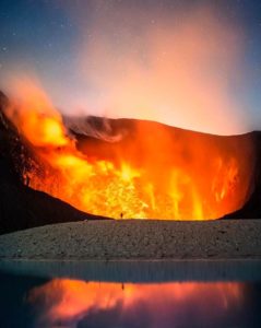
Iceland , Grímsvötn :
uncertainty level due to glacial flood in Grímsvötn
Specialists are expecting an eruption to occur in Grímsvötn in a matter of hours or days.
The National Commissioner of the Icelandic Police has declared an uncertainty level of civil protection due to the glacial flood in Grímsvötn.
This is done in consultation with the police chief in South Iceland, as stated in a notice from the Civil Protection. It states that the Icelandic Met Office estimates that the maximum flow will not exceed 1,000 cubic meters per second, based on the amount of water that has been collected in Grímsvötn.
As mbl.is first reported this morning, a glacial outburst flood has started in Grímsvötn and a volcanic eruption is therefore considered likely.
Magnús Tumi Gudmundsson, professor of geophysics at the University of Iceland, told mbl.is earlier today that a volcanic eruption in Grímsvötn would be an explosive eruption, which would most likely disrupt air traffic.
The Icelandic Civil Protection says that travel routes east of Mt Grímsfjall can be very dangerous due to formation of fissures and craters. Therefore, they ask tourists to be careful in this area.
The flight colour code above Grímsvötn had been raised to yellow due to the glacial outburst flood, meaning that the volcano shows signs of activity beyond normal.
This morning, the largest earthquake since the beginning of the measurements was detected in Grímsfjall, which measured 4.3 in magnitude.
A volcanic eruption is likely to occur within the next few hours or days, if it happens.
Source : https://icelandmonitor.mbl.is/
Photo : Icelandic Coast Guard.
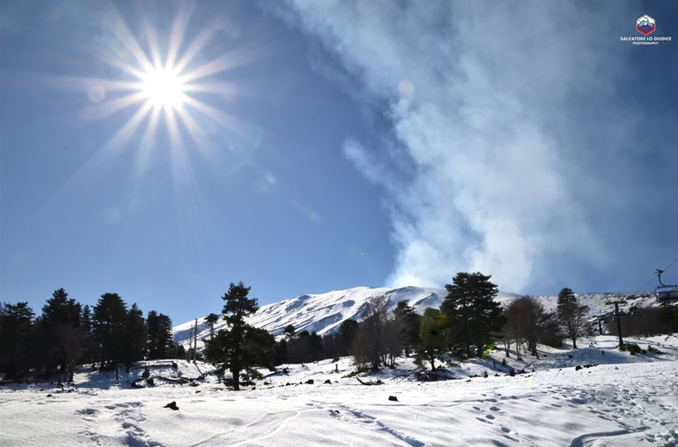
Italy / Sicily , Etna :
WEEKLY BULLETIN, from January 1, 2024 to January 7, 2024. (issue date January 9, 2024)
SUMMARY STATEMENT OF ACTIVITY
In light of the monitoring data, it appears:
1) VOLCANOLOGICAL OBSERVATIONS: Degassing activity at the Bocca Nuova Crater (BN) and the South-East Crater (CSE).
2) SEISMOLOGY: Low seismic activity due to fracturing; stationarity of volcanic tremor parameters.
3) INFRASOUND: Moderate activity, the sources were located in correspondence with the Bocca Nuova crater.
4) GROUND DEFORMATIONS: Over the past week, ground deformation monitoring networks have not recorded any significant changes.
5) GEOCHEMISTRY: The SO2 flux in the plume is at average values
The CO2 fluxes emitted by the ground are at average values.
The partial pressure of CO2 dissolved in groundwater presents values included in seasonal variability.
Helium Isotope Ratio: There are no updates.
6) SATELLITE OBSERVATIONS: Thermal activity observed by satellite was generally weak.
VOLCANOLOGICAL OBSERVATIONS
The monitoring of Etna’s volcanic activity was carried out through the analysis of images from the INGV surveillance camera network, Osservatorio Etneo (INGV-OE). Observations of activity at the summit craters were limited to a few hours, or even impossible throughout the day, due to poor weather conditions.
As already described for the previous week (Rep. N. 1/2024 ETNA), during the period examined, the activity of the summit craters of Etna was characterized by degassing of variable intensity, at the crater of the Bocca Nuova (BN) and the South-East Crater (CSE). The Voragine crater (VOR) and the North-East crater (CNE) remain obstructed and present limited degassing produced by small fumaroles.
Source : INGV.
Photo : Salvatore Lo Giudice
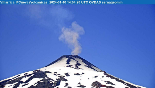
Chile , Villarica :
Special Report on Volcanic Activity (REAV), La Araucanía and Los Ríos regions, Villarrica volcano, January 10, 2024, 12:38 p.m. local time (mainland Chile)
The National Geology and Mining Service of Chile (Sernageomin) announces the following PRELIMINARY information, obtained through the monitoring equipment of the National Volcanic Monitoring Network (RNVV), processed and analyzed at the Southern Andean Volcano Observatory (Ovdas):
On Wednesday January 10, 2024, at 11:03 a.m. local time (2:03 p.m. UTC), monitoring stations installed near the Villarrica volcano recorded a sustained earthquake associated with fluid dynamics inside the volcanic system (long period type), which was accompanied by a pulse of fine ashes.
The characteristics of the earthquake after its analysis are as follows:
ORIGINAL TIME: 11:03 a.m. local time (2:03 a.m. UTC)
REDUCED DISPLACEMENT: 16.9 (cm*cm)
ACOUSTIC SIGNAL: 6.1 Pascals (Pa) reduced to 1 km
DURATION: 240 seconds
The characteristics of the associated surface activity are as follows:
MAXIMUM HEIGHT OF THE COLUMN: 400 meters above the point of emission
DIRECTION OF SPREAD: Northeast (NE)
Observation :
This emission of particulate materials is characterized by having a fine ash content, which quickly disperses in the degassing column.
After this event, no changes were recorded in the seismic behavior of the volcano.
The technical volcanic alert is maintained at YELLOW level.
Source et photo : Sernageomin.
Colombia , Chiles / Cerro Negro :
Weekly activity bulletin of the Chiles and Cerro Negro Volcanic Complex (CVCCN)
Regarding the monitoring of the activity of the CHILES AND CERRO NEGRO VOLCANOES, the MINISTRY OF MINES AND ENERGY, through the COLOMBIAN GEOLOGICAL SERVICE (SGC), reports that:
In the week from January 2 to 8, 2024 and compared to the previous one, there was an increase in the number of earthquakes and the seismic energy released, maintaining the levels of occurrence important. The predominance of earthquakes associated with the fracturing of rocks within the volcanic edifice continued, followed by seismicity linked to fluid movement.
The earthquakes were located mainly to the south of the Chiles volcano, at distances of up to 4 km, with depths less than 6 km from its summit (4,700 m above sea level). The maximum magnitude recorded was 3.6 corresponding to an earthquake that occurred on January 3 at 9:47 a.m., felt by some residents of the Chiles indigenous reserve (municipality of Cumbal). The event recorded on January 7 at 5:23 a.m., with a magnitude of 3.1, was also reported as felt.
Surface deformation processes persist in the volcanic zone according to sensors installed on the ground and thanks to the processing of information from remote satellite sensors.
The evolution of activity in the CVCCN continues, due to internal processes derived from the complex interaction between the magmatic, hydrothermal system and the geological faults of the area, such that the probability of occurrence of energetic earthquakes which may be felt by the inhabitants of the zone of influence of the CVCCN is maintained.
Volcanic activity remains on YELLOW ALERT Status: Active volcano with changes in baseline behavior of monitored parameters and other manifestations
Source et photo : SGC
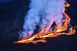
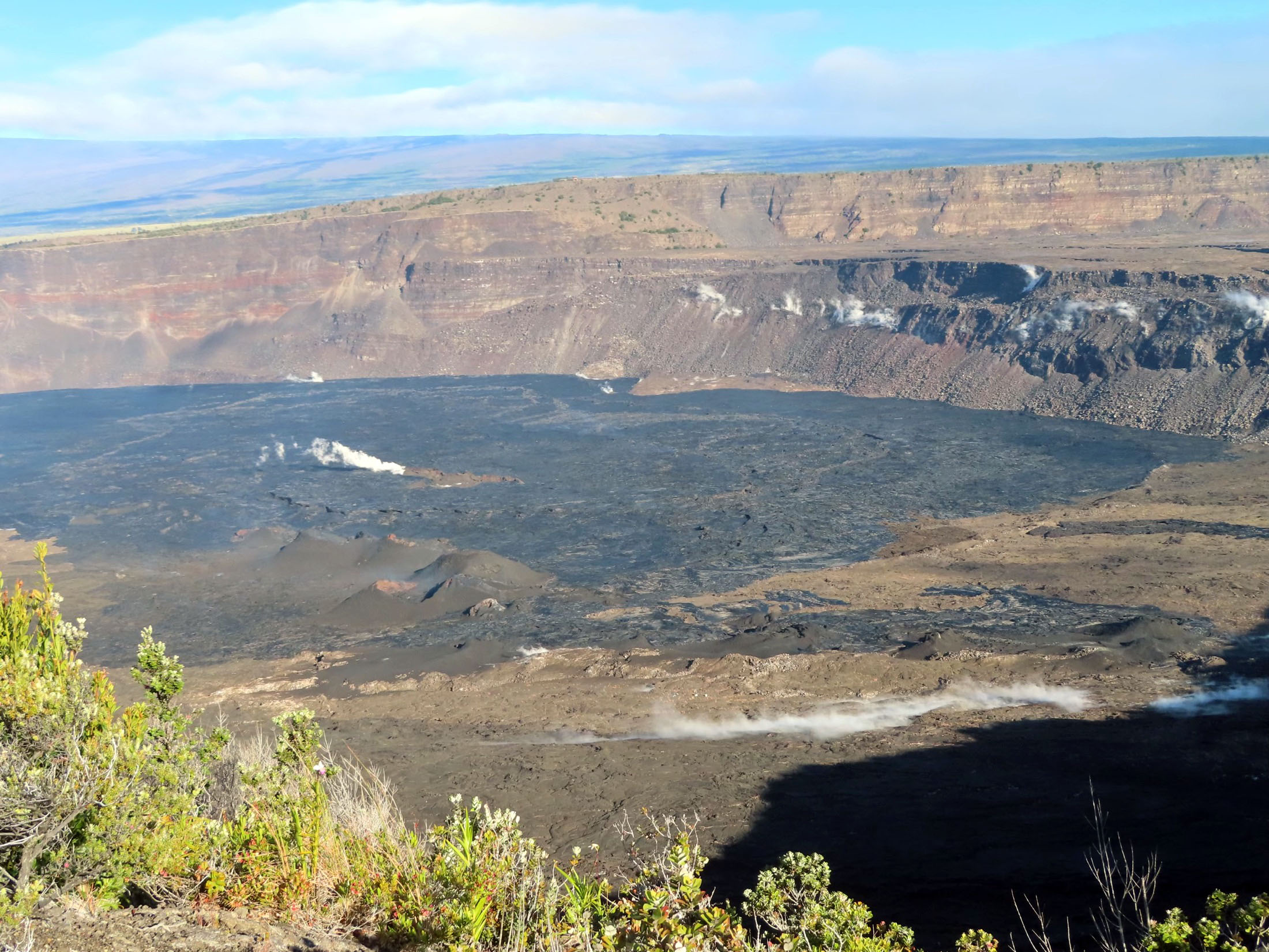
Hawaii , Kilauea :
Thursday, January 11, 2024, 9:15 AM HST (Thursday, January 11, 2024, 19:15 UTC)
19°25’16 » N 155°17’13 » W,
Summit Elevation 4091 ft (1247 m)
Current Volcano Alert Level: ADVISORY
Current Aviation Color Code: YELLOW
Activity Summary:
Kīlauea volcano is not erupting. Over the past day seismicity has been low in the summit region, upper East Rift Zone, and Southwest Rift Zone. Unrest may continue to wax and wane with fluctuating input of magma to the area, and eruptive activity could occur in the near future with little or no warning. No unusual activity has been noted along the middle and lower sections of Kīlauea’s East Rift Zone.
Summit Observations:
Over the past 24 hours, seismicity in Kīlauea’s summit region slightly increased, with approximately 20 small-magnitude earthquakes (less than M2) recorded beneath the caldera. The region south and southwest of the caldera remains quiet. Periods of increased shallow seismicity can be expected to continue during repressurization of the summit magma reservoir, which has been ongoing since the end of the September 2023 eruption. Seismicity has not reached the levels that immediately preceded recent summit eruptions at Kīlauea.
Kīlauea’s summit region remains at a high level of inflation; relative tilt is above the level reached prior to the most recent eruption in September 2023, and it is higher than at any time since the 2018 eruption. Summit tilt showed mild inflation over the past 24 hours (about a couple microradians).
Sulfur dioxide (SO2) gas emission rates remain low. Field measurements indicated an SO2 emission rate of approximately 80 tonnes per day on December 28, which was similar to measurements in October, November, and early December
Source : HVO
Photo : USGS / J. Chang.