Mach 9 , 2021.
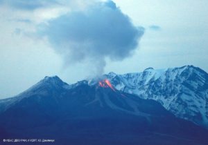
Philippines , Taal :
TAAL VOLCANO BULLETIN 9 March 2021 8:00 AM
This serves as notice for the raising of the alert status of Taal from Alert Level 1 (low level of unrest) to Alert Level 2 (increasing unrest).
Since 13 February 2021, Taal Volcano has been exhibiting increased unrest based on the following monitoring parameters:
Volcanic Earthquakes.
The Taal Volcano Network (TVN) recorded a total of twenty-eight (28) volcanic tremor episodes, four (4) low frequency volcanic earthquakes (LFVQs), and one (1) hybrid earthquake at shallow depths of less than one and a half (1.5) kilometers beneath Taal Volcano Island or TVI in the past 24 hours. Volcanic tremors have increased seismic energy compared to previously recorded episodes and ranged between three (3) to seventeen (17) minutes in duration. The total number of volcanic tremor events has risen to 866 since the onset of increased activity on 13 February. In addition to these, a total of 141 LFVQs have occurred within one (1) kilometer depths beneath TVI and immediate vicinities. Overall, seismic activity in the past month indicates increased magmatic and hydrothermal activity at shallow depths beneath TVI.
Changes in the Main Crater Lake (MCL).
Survey observations in mid-February 2021 recorded a temperature high of 74.6ºC and continuing increase in acidity to pH 1.59 from a pH of 2.79 in January 2020 of the MCL. Increasing acidity is caused by sustained volcanic gas input into the shallow hydrothermal system that feeds into the lake, signifying degassing of magma intruded at depth during the January 2020 eruption.
Ground Deformation.
Integrated real-time ground tilt and continuous GPS and daily Electronic Distance Measurement (EDM) monitoring and Interferometric SAR (InSAR) data analysis indicate ongoing slight deformation of TVI centered on a pressure source on its southeast sector. Continuous GPS and InSAR data further yield a very slow but steady inflation and/or expansion of the Taal region since the end of the 2020 eruption, at very much slower and stabilized rates compared to deformation before and right after the eruption.
Microgravity Changes.
Campaign surveys have measured positive microgravity changes across Taal Caldera after the 2020 eruption consistent with density changes caused by magma migration, magma degassing and hydrothermal activity.
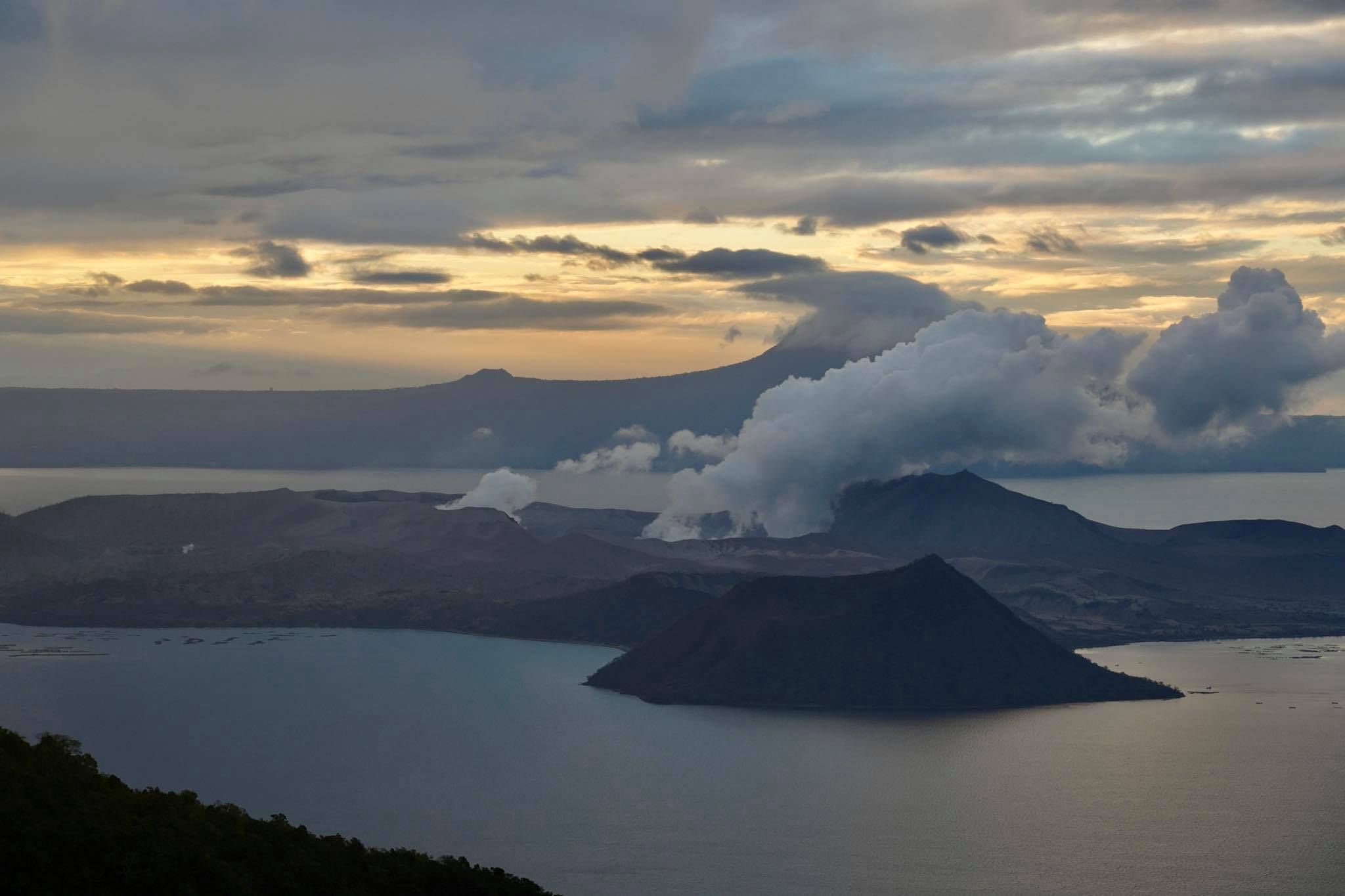
In view of the above, DOST-PHIVOLCS is now raising the alert status of Taal from Alert Level 1 to Alert Level 2. This means that there is probable magmatic activity that may or may not lead to an eruption. At Alert Level 2, evacuation is not yet recommended. However, the public is reminded that Taal Volcano Island is a Permanent Danger Zone (PDZ) and that entry into TVI, especially the vicinities of the Main Crater and the Daang Kastila fissure, must remain strictly prohibited. Local government units are advised to continuously assess previously evacuated barangays around Taal Lake for damages and road accessibilities and to strengthen preparedness, contingency, and communication measures in case of renewed unrest. Residents of these barangays are advised to be always prepared, to keep calm and listen to information only from trusted or verified sources. Civil aviation authorities must advise pilots to avoid flying close to the volcano as airborne ash and ballistic fragments from sudden explosions and wind-remobilized ash may pose hazards to aircraft. DOST-PHIVOLCS is closely monitoring Taal Volcano’s activity and any new significant development will be immediately communicated to all stakeholders.
Source : Phivolcs .
Photos : Quezon Trending News , Raffy Tima .
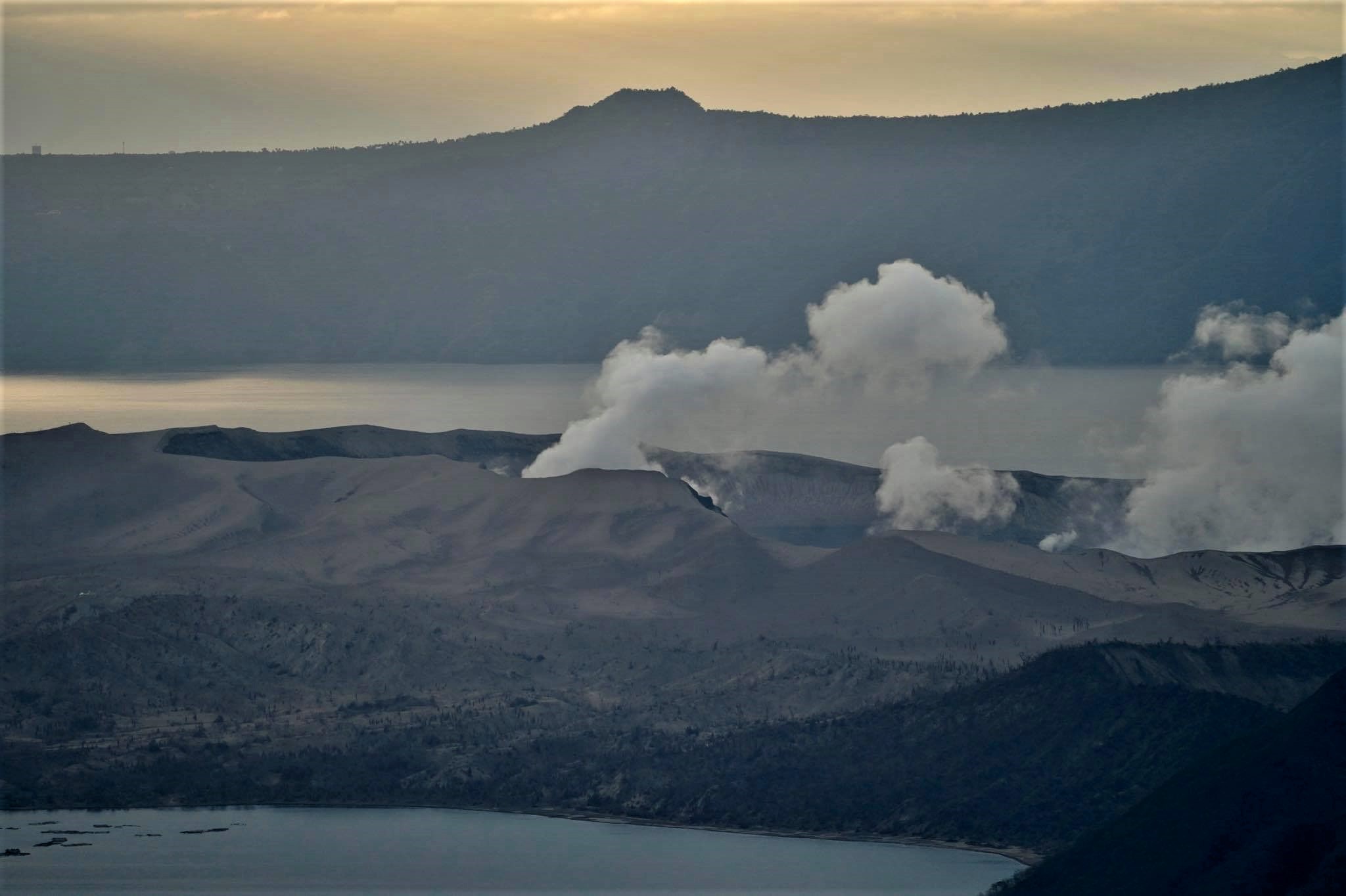
Italy / Sicily , Etna :
Press release on ETNA activity, 08 March 2021, 11:54 (10:54 UTC).
The National Institute of Geophysics and Volcanology, Osservatorio Etneo, announces that it is observed that the lava flows set up in the Valle del Bove during the eruptive activity of March 7, are no longer fed and their fronts are cooling. Thanks to the analysis of the images of the surveillance cameras INGV-OE, it was observed that the lava field developed by branching into three different arms, the most extensive lava flow affected the western sector of the Valle dei Bove extending up to approximately ~ 1800 meters. above sea level. Eruptive activity continues at the level of the other summit craters.
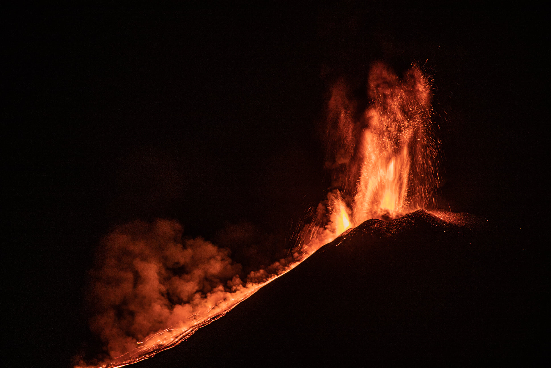
At present, the amplitude of the volcanic tremor corresponds to average values. The source of the tremor is near the Bocca Nuova crater, the number of infrasound events is high and their location is near the Bocca Nuova crater.
GNSS and inclinometric monitoring networks do not record significant distortion signals.
Other updates will be announced soon.
Source : INGV .
Photo : Guide Alpine Vulcanologiche Etna
Guatemala , Pacaya :
SPECIAL VOLCANOLOGICAL BULLETIN, March 8, 2021, 6:24 p.m. local time.
UPDATE ON ERUPTIVE ACTIVITY
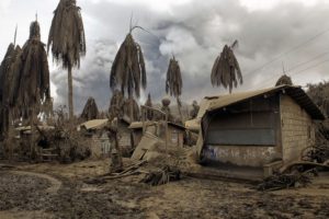
As has been reported, the Pacaya volcano maintains pulses of increased Strombolian activity, observing constant moderate explosions and a few strong explosions, expelling ballistic and volcanic material at an altitude of about 3000 to 3500 meters above the level of the sea (9,842 to 11,483 feet). This is accompanied by columns of ash that move in southwest, south and southeast directions for a distance of 25 to 30 kilometers, sometimes further.
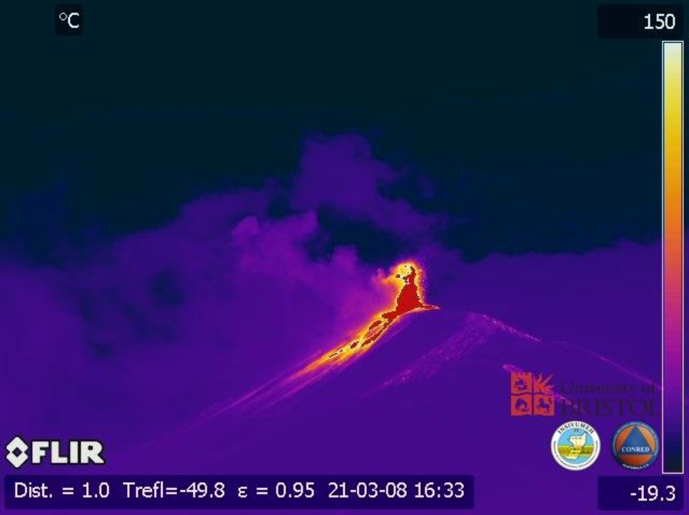
Ash falls are reported in the village of Pacaya, Finca El Chupadero, Finca La Laguna and others in this region. The described activity generates rumblings and vibrations in the houses around the volcanic building. The OVPAC reports that the ballistic projections reach 500 to 600 meters above the Mackenney crater. Effusive activity has increased and a lava flow of about 1,300 meters in length is observed, with the probability of generating others on other sides of the volcano.
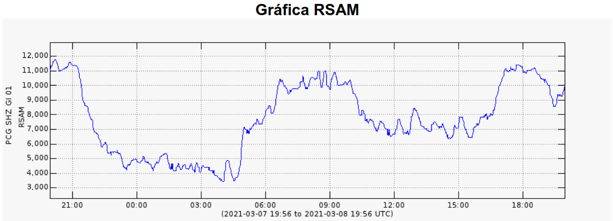
INSIVUMEH provides surveillance through PCG and PCG5 seismic stations, OVPAC, CONRED web cameras, as well as with instrumental and visual monitoring of activity due to any sudden changes.
Source : Insivumeh .
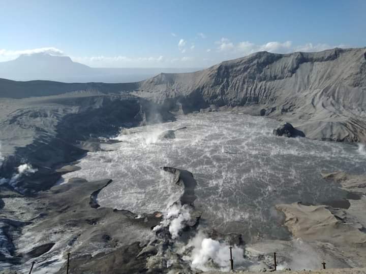
Hawaii , Kilauea :
19°25’16 » N 155°17’13 » W,
Summit Elevation 4091 ft (1247 m)
Current Volcano Alert Level: WATCH
Current Aviation Color Code: ORANGE
Activity Summary:
Kīlauea Volcano is erupting. Lava activity is confined to Halemaʻumaʻu, with lava erupting from a vent on the northwest side of the crater and flowing into a growing lava lake. Laser rangefinder measurements this morning, March 8, indicate that the total depth of the lava lake is 220 m (722 ft). SO2 emission rates remain elevated; a measurement on March 7 was 800 t/day.
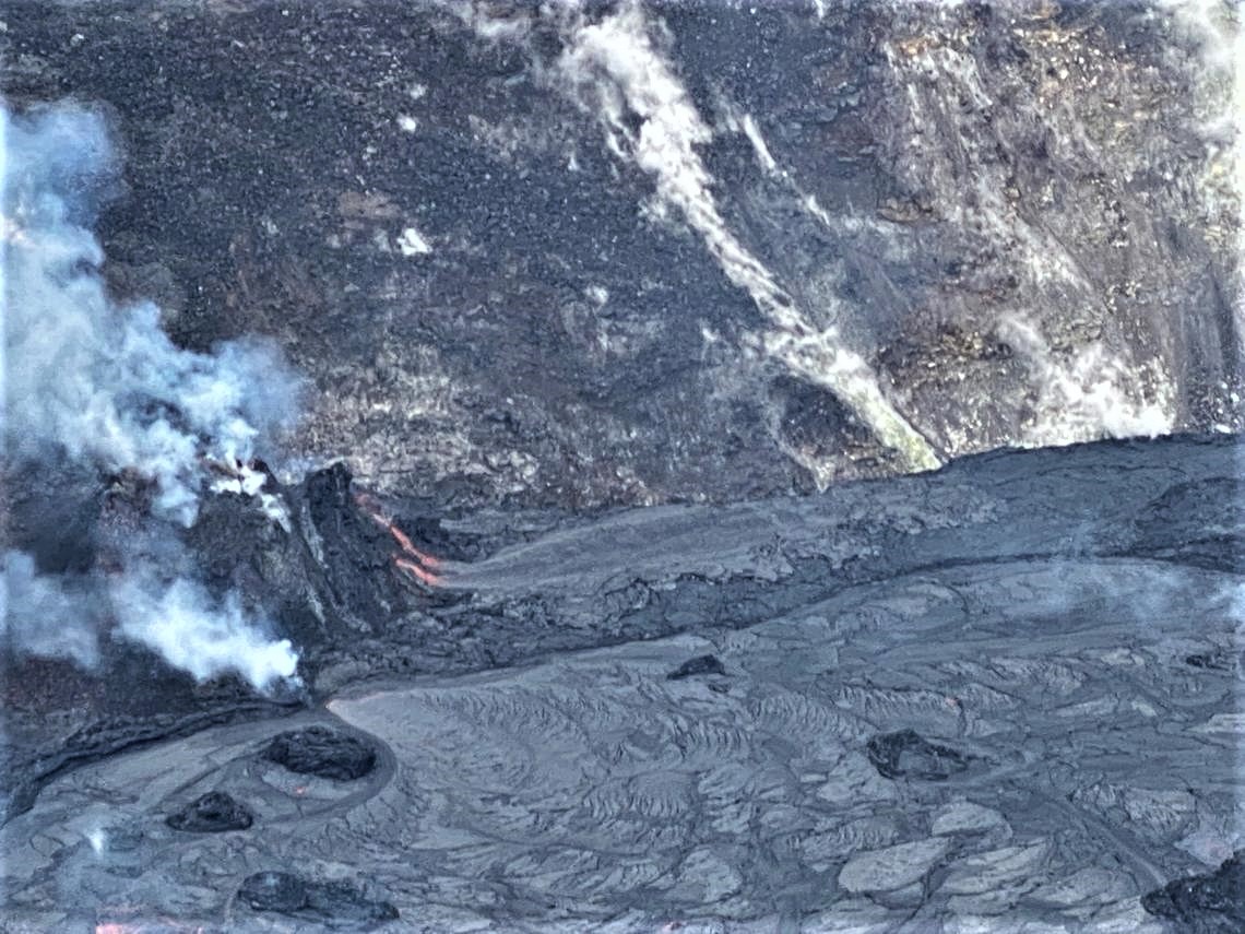
A zoomed-in photo of the west vent (left) in Halema‘uma‘u crater, Kīlauea summit, about a half hour after the observed lava flow started on the north side of the vent. The activity began with weak incandescent spatter being thrown from the top of the cone at 11:45 a.m. HST, gradually increasing in vigor for about 30 minutes. The molten spatter fed two small lava channels down the northeast side of the cone (center-left). The flows merged at the base of the cone and continued to flow along the northern stagnant lava lake margin
Summit Observations:
The most recent sulfur dioxide emission rate, measured on March 7, is 800 t/d; this is elevated compared to rates in the months before the eruption started on December 20 (less than 100 t/day), but lower than rates from the pre-2018 lava lake (around 5,000 t/day). Summit tiltmeters have been flat since yesterday afternoon, after tracking a deflation-inflation (DI) event over the preceding two days. Seismicity remains stable, with elevated tremor compared to observations before the eruption.
Halemaʻumaʻu lava lake Observations:
Lava effusion from the west vent continues to supply the lava lake within Halema‘uma‘u crater. The main section of the west vent is consistently effusing lava through a crusted-over channel and submerged inlet to the lake.
The northeast section of the west vent, just several meters (yards) away, has been feeding another lava flow near the lake since March 5. By midday yesterday this flow had built a perched lava pond on the northwest lake margin within 50 m (164 ft) of the vent, but it abruptly collapsed into the main lava lake just after 1:00 PM. Since then, the flow from the northeast section of the vent has stabilized into a second semi-steady inlet to the lava lake.
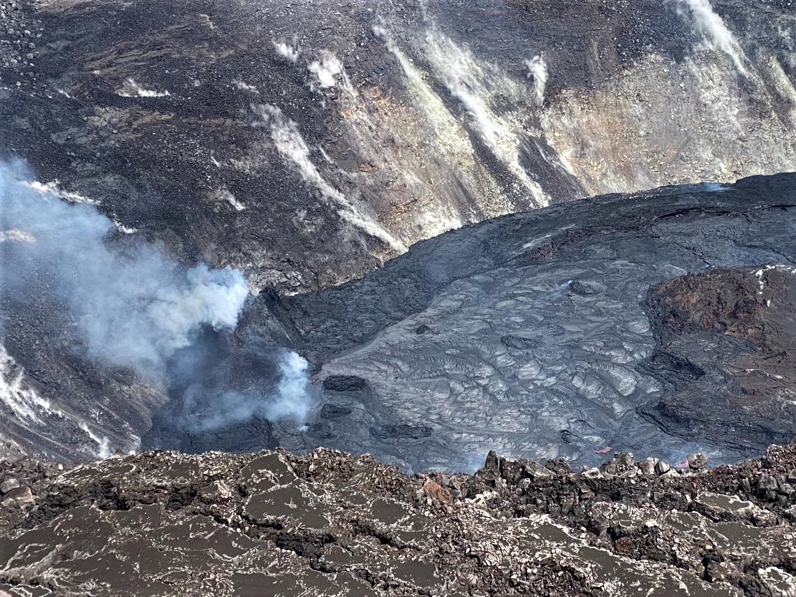
On Friday, HVO geologists observed a breakout from the west vent within Halema‘uma‘u crater at the summit of Kīlauea Volcano. This photo shows the vent about an hour before the breakout occurred on the northern side of the cone. Note that no glow or spatter can be seen from the cone (center-left), but loud hissing noises from the vent area were audible to field crews.
Lava circulation and intermittent foundering of thin crust continue in the active western portion of the lava lake. The total depth of the lake is approximately 220 m (722 ft) as measured by a continuous laser rangefinder this morning; this represents a slight rise from levels the past couple days, following the trend of summit inflation at the end of the most recent DI event.
Stagnant and solidified lava crust covers the eastern portion of the lava lake and is slowly growing westward around the main island, apparently preventing any lateral movement of this island or any of the smaller enclosed islands. Rangefinder measurements and visual observations indicate that the crust in the eastern portion of the lava lake is still rising at a rate similar to the active western portion of the lake, suggesting continued accumulation of liquid lava below the crust.
Source : HVO.
Photos : USGS/J. Schmith on March 5, 2021 ,